Browse Listings in Europe
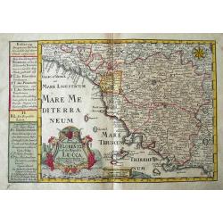
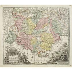
Das Groshertzogthum Florentz und die Republic Lucca...
Fine map of Tuscany. Extends from Genoa until Civitavecchia, and inland until Cervia. With Elba and Isola del Giglio. Filled with place names, such as Florence, Siena, Lu...
Date: Leipzig, 1749
Selling price: ????
Please login to see price!
Sold in 2018
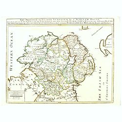
The Province of Ulster Surveyed by Sir William Petty. . .
This map of Ulster (present-day Northern Ireland), published in London by T.Jefferys is based on the Down Survey of Ireland undertaken in 1656–1658. As indicated in the...
Date: London, ca. 1749
Selling price: ????
Please login to see price!
Sold in 2016
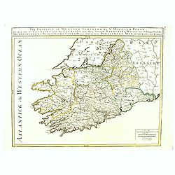
The Province of Munster Surveyed By Sr. William Petty : Divided into its Counties and the Counties into their serevall Barronies, Wherein are distinghished the . . .
This map of Ulster (present-day Northern Ireland), published in London by T.Jefferys is based on the Down Survey of Ireland undertaken in 1656–1658. As indicated in the...
Date: London, ca. 1749
Selling price: ????
Please login to see price!
Sold in 2016
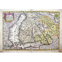
Das Gros=Hertzogthum Finland...
Very detailed map of southern Finland until Oulo, extending to include parts of Sweden with Stockholm, Revel (today Tallinn), St. Petersburg, and a part of the White Sea ...
Date: Leipzig, 1749
Selling price: ????
Please login to see price!
Sold in 2017
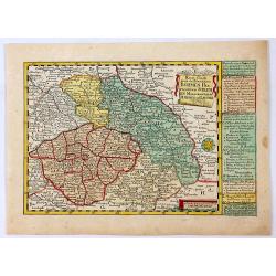
Reise Charte durch das Konigreich Bohmen Hertzogthum Schlesien.
A hand colored map showing the region which is now southern Poland and the Czech Republic with the cities of Prague, Olmutz (Olomouc), and Breslaw (Wroclaw). Includes exp...
Date: Leipzeg, 1749
Selling price: ????
Please login to see price!
Sold in 2018
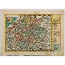
Reise Charte Durch Deutschland.
A pleasing map of Germany by George Schriebern, published in the 'Atlas Selectus' with explanatory text and directory on the right of map With decorative title cartouche ...
Date: Leipzeg, 1749
Selling price: ????
Please login to see price!
Sold in 2018
Partie Meridionale du Comte de Bourgogne ou Franche-Comte...
A striking map of the Burgundy (Bourgogne) and southern Franche-Comte region of eastern France by Robert de Vaugondy, published in 1749.It covers part of the southern Fra...
Date: Paris, 1749
Selling price: ????
Please login to see price!
Sold in 2018
Partie Septentrionale du Comte de Bourgogne ou Franche Comte...
A striking, detailed map of the Burgundy and northern Franche-Comte region of eastern France by Robert de Vaugondy. It covers the modern day departments of Doubs, Haute-S...
Date: Paris, 1749
Selling price: ????
Please login to see price!
Sold in 2018
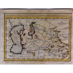
Carte de Karasm, Turkestan et Grand Bukarie...
The Timurids. A Central Asian Sunni Muslim dynasty, of Turko-Mongol descent, whose empire included the whole of Iran, modern Afghanistan, and modern Uzbekistan, as well a...
Date: Paris, 1749
Selling price: ????
Please login to see price!
Sold in 2021
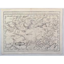
Carte de la Tartarie Occidentale. . .
A detailed copper engraved map of northeast Asia and Siberia, from Lake Baykal. Partie du Siberie in the north, Pays des Kalkas at the centre as well as Desert de Sable, ...
Date: Paris, 1749
Selling price: ????
Please login to see price!
Sold in 2019
![To Martin Folkes Esq[ui]r[e] President of the Royal Society: This Plan of the Cities of London with the Contiguous Buildings. . .](/uploads/cache/83535-250x250.jpg)
To Martin Folkes Esq[ui]r[e] President of the Royal Society: This Plan of the Cities of London with the Contiguous Buildings. . .
A plan of London, Westminster and Southwark published in London in 1749. The text below the plan states that the map was taken from Rocque’s great survey of the city, t...
Date: London, 1749
Selling price: ????
Please login to see price!
Sold in 2020
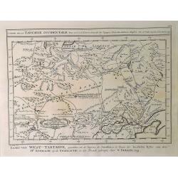
Carte de la Tartarie Occidentale pour Servir a L'Histooire General des Voyages.
A detailed map of Western Tartary, including Siberia, the Sable Desert, Mongolia and part of Northern China. Showing roads, towns, rivers, lakes, mountains, etc. In the c...
Date: Paris, 1749
Selling price: ????
Please login to see price!
Sold in 2021
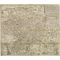
Circuli Westphaliae. . .
Johann Baptist Homann's well-engraved map has a large decorative cartouche. Detailed map of the south-western part of Poland covering the towns of Legnica, Wroclaw, Opole...
Date: Nuremberg 1749
Selling price: ????
Please login to see price!
Sold in 2022
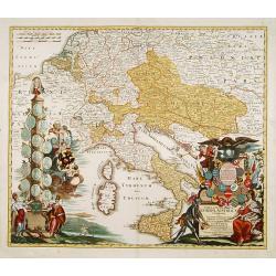
Tabula Geographica Europae Austriacae generalis..
Johann Baptist Homann's well-engraved map has a large decorative cartouche at bottom right and left showing a throned ruler, showing the Austrian possessions in Europe.
Date: Nuremberg 1750
Selling price: ????
Please login to see price!
Sold
Royaume d'Irlande divisé en ses quatre Provinces
Fine map of Ireland, engraved by the master Delahaye. Fine title cartouche.
Date: Paris 1750
Selling price: ????
Please login to see price!
Sold
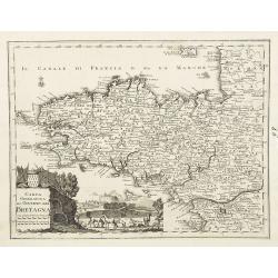
Carta geografica del governo della Bretagna. . .
From Volume II of Albrizzi's "Atlante Novissimo" after Guillaume de L'Isle. Showing Brittany divided into its Bishoprics and with all towns and cities marked, w...
Date: Venise, 1750
Selling price: ????
Please login to see price!
Sold
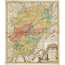
Comitatus Burgundiae tam in primarias ejus ..
A good map of Burgundy orientated with north at the top. Decorative title cartouche with three figures, scale cartouche, coat of arms and putti holding grapes.Lower part ...
Date: Augsburg 1750
Selling price: ????
Please login to see price!
Sold
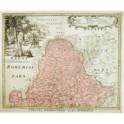
Circuli Olomucensis pars Borealis.
Beautiful decorative cartouche upper right with the legend and very beautiful figurative scene upper left corner.
Date: Nurimberg, c.1750
Selling price: ????
Please login to see price!
Sold
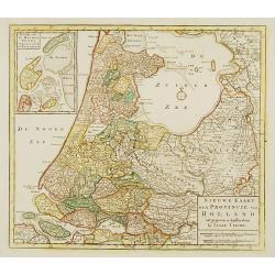
Nieuwe kaart der Provincie van Holland.
In upper left hand corner inset map of Kaartje van de Helder Texel Vlieland en Wieringen . Including the province of Utrecht and the Veluwe.
Date: Amsterdam 1750
Selling price: ????
Please login to see price!
Sold
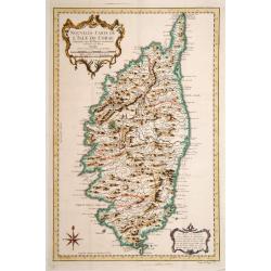
Nouvelle Carte de L'Isle de Corse..
Fine map of Corsica.
Date: Paris 1750
Selling price: ????
Please login to see price!
Sold
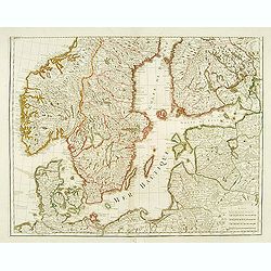
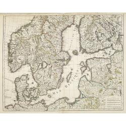
(Map of Scandinavia).
Engraved by "Liébaux, le fils".
Date: Paris, 1750
Selling price: ????
Please login to see price!
Sold in 2008
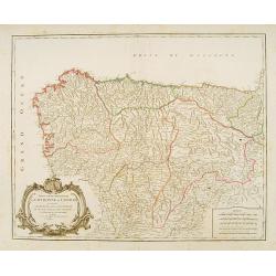
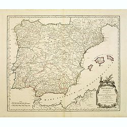
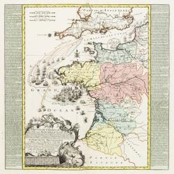
Partie septentrionale de la Couronne de Castille
Detailed map of the north-western part of Spain. Also depicting a small part of southern France.
Date: Paris 1750
Selling price: ????
Please login to see price!
Sold
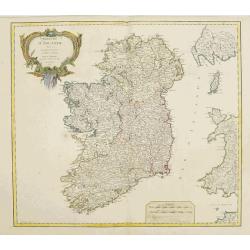
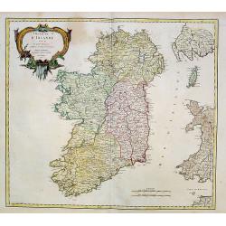
Royaume d'Irlande.
Nice large map of the kingdom of Ireland,divided in the 4 provinces and subdivided in counties,also showing a part of England and of Scotland, fully colored by hand. From...
Date: Paris, 1750
Selling price: ????
Please login to see price!
Sold
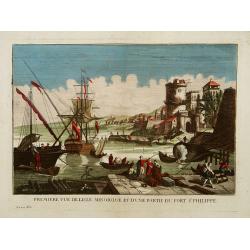
Première vue de l'Isle minorque et d'une partie du Fort St Philippe.
A so-called optical print of the harbour of Majorcal.In the eighteenth and nineteenth centuries there were many popular speciality establishments in Paris, Augsburg and L...
Date: Paris 1750
Selling price: ????
Please login to see price!
Sold
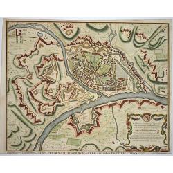
The city of Namur..
Nice fortification plan of the city Namur, with houses churches and even the gardens are visible. A decorative cartouche in the corner. Engraved by J. Basire.
Date: London ca. 1750
Selling price: ????
Please login to see price!
Sold
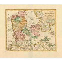
Nieuwe Kaart van het Koninkryk van Deenemarken. 1734.
Izaak Tirion (d. 1769) Amsterdam publisher. His ' Nieuwe en beknopte handatlas' saw 6 editions between before 1740 and after 1784. Also ' Tegenwoordige staat van alle vol...
Date: Amsterdam, c. 1750
Selling price: ????
Please login to see price!
Sold
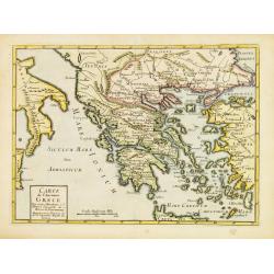
Carte de l'Ancienne Grece ..
Uncommon map of ancient Greece. For Introduction à l'Histoire Universelle du Baron de Puffendorf.
Date: Paris c.1750
Selling price: ????
Please login to see price!
Sold
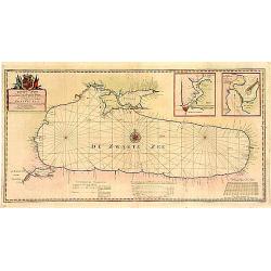
Aan zyne .. Paskaart van de Zwarte Zee..
A very fine and rare chart of the Black Sea with inset plans of Bosporus and Istanbul and another inset of Kerchensky Strait. Prepared by J.van Woensel.Embellished with a...
Date: Amsterdam 1750
Selling price: ????
Please login to see price!
Sold
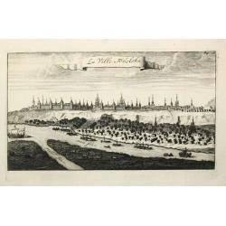
La Ville Tobolska.
A view of the town of Tobolska on the Irtis and Tobol rivers.
Date: Amsterdam, c. 1750
Selling price: ????
Please login to see price!
Sold
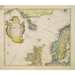
Tabula Geographica Europae..
Interesting map centered on the Faroe Islands. It extends from the eastern coast of Greenland as far as Sweden, showing Iceland and the British Isles.Engraved by N.F. Sau...
Date: Berlin c.1750
Selling price: ????
Please login to see price!
Sold
Hispania Antiqua.
Map of ancient Spain and Portugal. Engraved by G. Delahaye.
Date: Paris, 1750
Selling price: ????
Please login to see price!
Sold
Ducatus Westphalia novâ mappâ Geographicâ..
Map centered on eastern Germany.
Date: Augsburg 1750
Selling price: ????
Please login to see price!
Sold
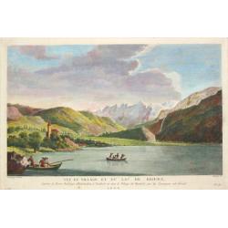
Three very fine views of Switzerland
A view of the village and lake of Brienz. - A view of the village and lake of Lucerne.. - A view of Interlachen. After le Barbier. Together three views in Switzerland.
Date: France, ca. 1750
Selling price: ????
Please login to see price!
Sold in 2019
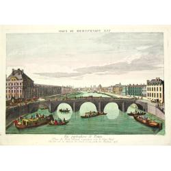
Vue particulierie de Paris. Prise du Pont Royal regardant vers le Pont Neuf. Ou l''on voit les Galeries du Louvre et une partie des Thuilleries cs.
A beautiful optical view of Pont Neuf with the Louvre in Paris.
Date: Paris, c. 1750
Selling price: ????
Please login to see price!
Sold in 2008
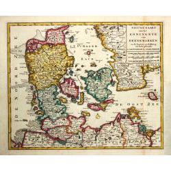
Nieuwe Kaart van het Koninkryk van Deenemarken. 1734
Izaak Tirion (d. 1769) Amsterdam publisher. His ' Nieuwe en beknopte handatlas' saw 6 editions between before 1740 and after 1784. Also ' Tegenwoordige staat van alle vol...
Date: Amsterdam, c. 1750
Selling price: ????
Please login to see price!
Sold

Vue perspective de la Cathedrale de Milan.
An optical view of the Dome of Milan.
Date: Paris, c. 1750
Selling price: ????
Please login to see price!
Sold
Brittische Übermacht Zur See wieder Franckreich..
Fascinating and finely engraved map engraved by M.A.Lotter and sold by his father, T.Lotter.It describes naval skirmishes between the British and French during the Seven ...
Date: Paris 1750
Selling price: ????
Please login to see price!
Sold in 2010
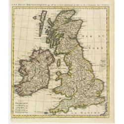
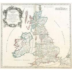
Les Isles Britanniques par Mr. De L'Isle. Geographe du Roy &c.
Uncommon map of the British Isles, after de L'Isle. In lower left bottom : cette carte doit etre placée au commencement des Tomes 2.3.4. & suivans.
Date: Paris ca 1750
Selling price: ????
Please login to see price!
Sold
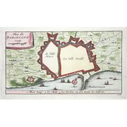
Barcelone
Nice small city plan of Barcelona with the fortification walls. With a few ships in the sea.
Date: ca. 1750
Selling price: ????
Please login to see price!
Sold
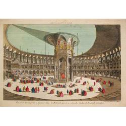
Vue de la Compagnie a déjeuner dans la Rotonde qui est au milieu des Jardins de Renelagh a Londres.
An optical view of a meal held in the Rotonde in Renelagh park in London.
Date: Paris, c. 1750
Selling price: ????
Please login to see price!
Sold in 2020

Vue de l'Interieur de l Église Cathedrale de notre Dame de Paris.
An optical view of the interior of the Notre Dame in Paris.
Date: Paris, c. 1750
Selling price: ????
Please login to see price!
Sold
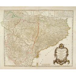
Etats de la Couronne d'Aragon?
Detailed map of a province of Spain. Numerous place-names of counties, cities, towns, physical features.
Date: Paris, c.1750
Selling price: ????
Please login to see price!
Sold
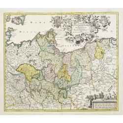
Marchionatus Brandenburgensis Ducatus Pomeraniae et Ducatus Mecklenburgicus..
Seutter's well-engraved map has a large decorative cartouche. Including the towns of Wismar, Stettin, Berlin, etc.
Date: Nuremberg, 1750
Selling price: ????
Please login to see price!
Sold in 2008
Provincia Gallis la Provence dicta..
Seutter's well-engraved map has two large decorative cartouche. Including the towns of Marseille, Toulouse, St.Tropez, Cannes, Antibes, etc.
Date: Nuremberg 1750
Selling price: ????
Please login to see price!
Sold
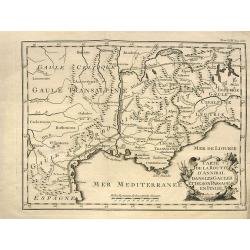
Carte de la route d'Annibal dans les Gaules et de son passage en Italie.
Interesting map showing the route of Hannibal. With south France and Liguria. After a map by Liebaux, a later edition probably from "Histoire Universelle".
Date: Paris, c1750
Selling price: ????
Please login to see price!
Sold in 2013
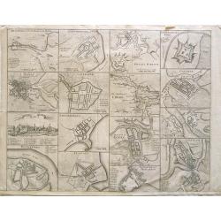
Cities of Ireland (no title).
Sixteen town- plans on one sheet (not numbered): 1:Drogheda, with the battle at the Boyne 2: Londonderry 3:Kinsaile Harbour 4: Chaliamount Fort 5: The city of Dubli...
Date: ca. 1750
Selling price: ????
Please login to see price!
Sold in 2013
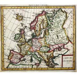
Carte de l'' Europe.
A small map of the European continent.
Date: paris, c. 1750
Selling price: ????
Please login to see price!
Sold in 2008
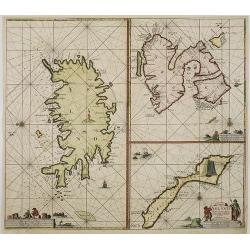
Paskaart van Ysland Spitsberge en Jan Mayen Eyland. . .
Three charts on one sheet. In the left hand part of the page a chart of Iceland. To the upper right "Spitsbergen" and lower right "Jan Mayen Island".P...
Date: Amsterdam, ca.1750
Selling price: ????
Please login to see price!
Sold in 2016
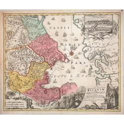
Provinciarum Persicarum Kilaniae nempe Chirvaniae Dagestaniae.
Very decorative map of the southern part of the Caspian Sea, Caucasus and Turkmenistan, by J B. Homann. A nice view of the city of Baku (the former Tereki) in a decorativ...
Date: Nuremberg, 1750
Selling price: ????
Please login to see price!
Sold in 2013
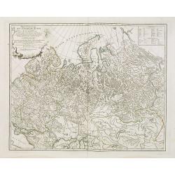
Partie Occidentale de l'Empire de Russie . . .
Map of the western part of the Russian Empire, north of the Black Sea and the Caspian Sea, Nova Zembla, including most of Finland.
Date: Paris, ca. 1750
Selling price: ????
Please login to see price!
Sold in 2009
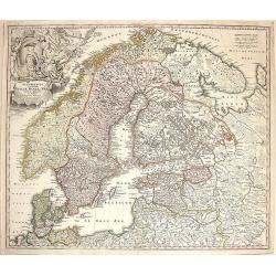
Scandinavia complectens Sueciae, Danaie & Norvegiae Regna.
Map of Scandinavia centerd on Sweden, Norway and Denmark.
Date: Nuremberg, 1750
Selling price: ????
Please login to see price!
Sold in 2009
Mer Baltique - Golfe de Bothnie.
The map is centered on the Baltic Sea, including Denmark, Finland, a part of Poland, and southern parts of Norway and Sweden. Engraved by Liébaux le fils.
Date: Paris, 1750
Selling price: ????
Please login to see price!
Sold in 2009
Britannicae, Insulae in quibus Albion sen Britannia Major, ...
British Isles by de Vaugondy.
Date: Paris, 1750
Selling price: ????
Please login to see price!
Sold in 2009
Florence. Florence Ville d'Tialie, capitale de Toscane. . .
A very decorative and extremely rare town-view of Florence, in Tuscany. Including a 4-line text in lower part. Published by Jacques Chéreau, (1688 - 1776). Engraved by A...
Date: Paris, ca.1750
Selling price: ????
Please login to see price!
Sold in 2016
Genes. Ville Capitale de la Republique de meme nom seituée sur la mer méditerranée en Italie.
A very decorative and extremely rare of Genoa, including a numbered key ( 1-30 ) in lower part. Published by Jacques Chéreau, (1688 - 1776). Engraved by Aveline and fir...
Date: Paris, ca.1750
Selling price: ????
Please login to see price!
Sold in 2012
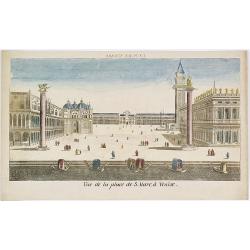
Vue de la Place de S.Marc à Venise.
Showing the St.Marco Square in Venice. Mondhard was a well-known publisher of optical prints, established in rue St.Martin in Paris. In the eighteenth and nineteenth cent...
Date: Paris, ca. 1750
Selling price: ????
Please login to see price!
Sold in 2009
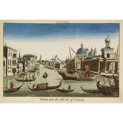
Venise vue du côté du g(rann)d canal.
Showing the Grand Canal in Venice. Likely published by Mondhard, a well-known publisher of optical prints, established in rue St.Martin in Paris. In the eighteenth and ni...
Date: Paris, ca. 1750
Selling price: ????
Please login to see price!
Sold in 2009
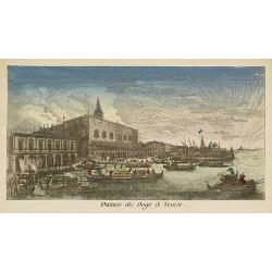
Palais du Doge à Venise.
Showing the Doge's Palace in Venice. Likely published by Mondhard, who was a well-known publisher of optical prints, established in rue St.Martin in Paris. In the eightee...
Date: Paris, ca. 1750
Selling price: ????
Please login to see price!
Sold in 2012
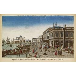
Eglise S.Théodore et entrée du grand canal de Venise.
Showing the entrance of the Grand Canal in Venice. Likely published by Mondhard, who was a well-known publisher of optical prints, established in rue St.Martin in Paris. ...
Date: Paris, ca. 1750
Selling price: ????
Please login to see price!
Sold in 2013
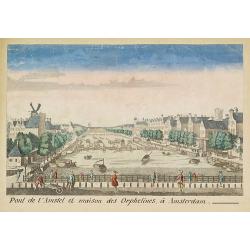
Pont de l'Amstel et maison des orphelines à Amsterdam.
Showing the Amstel bridge in Amsterdam. Likely published by Mondhard, who was a well-known publisher of optical prints, established in rue St.Martin in Paris. In the eigh...
Date: Paris, ca. 1750
Selling price: ????
Please login to see price!
Sold in 2011
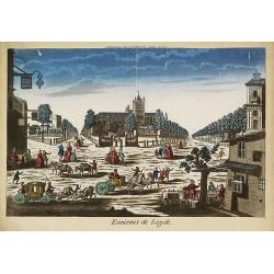
Environs de Leijde. (Vue des environs de Leyden)
Showing the market square in Leiden. J. Chereau was a publisher of optical prints, established in Paris, rue St.Jacques.In the eighteenth and nineteenth centuries there w...
Date: Paris, ca. 1750
Selling price: ????
Please login to see price!
Sold in 2012
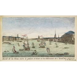
Bords de la Neva entre le palais d'hiver et les bâtiments de l'Acad.ie des Sciences à S.Pétersbourg.
Showing the Neva with the Winter Palace in St. Peterburg. J. Chereau was a publisher of optical prints, established in Paris, rue St.Jacques.In the eighteenth and ninetee...
Date: Paris, ca. 1750
Selling price: ????
Please login to see price!
Sold in 2012
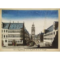
Vue d'Augsbourg vers la porte de la St. Vierge.
Showing a lively scene in 18th century Augsburg. J. Chereau was a publisher of optical prints, established in Paris, rue St.Jacques.In the eighteenth and nineteenth centu...
Date: Paris, ca. 1750
Selling price: ????
Please login to see price!
Sold in 2015

Intérieur de l'Eglise St.Marc à Venise.
Showing the interior of Saint Mark's Basilica in Venice. J. Chereau was a publisher of optical prints, established in Paris, rue St.Jacques.In the eighteenth and nineteen...
Date: Paris, ca. 1750
Selling price: ????
Please login to see price!
Sold in 2013
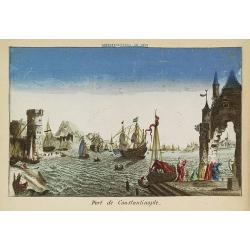
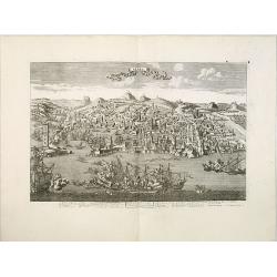
Port de Constantinople.
Showing a fanciful presentation of the harbor of Constantinople (Istanbul). J. Chereau was a publisher of optical prints, established in Paris, rue St.Jacques.In the eigh...
Date: Paris, ca. 1750
Selling price: ????
Please login to see price!
Sold in 2009
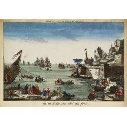
Ile de Malte, du côté du fort.
Showing to the right part of Fort St. Elmo at Valletta, with a lively foreground and a sea battle in the bay. The mirror-image title reads "Vue de Malthe du côté d...
Date: Paris, ca. 1750
Selling price: ????
Please login to see price!
Sold in 2009
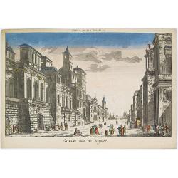
Grande rue de Naples.
Showing a street scene in Naples. J. Chereau was a publisher of optical prints, established in Paris, rue St.Jacques.In the eighteenth and nineteenth centuries there were...
Date: Paris, ca. 1750
Selling price: ????
Please login to see price!
Sold in 2016

Péristijle d'un palais de S. Pétersbourg.
Showing an arcade at the Royal Palace of Saint Petersburg. J. Chereau was a publisher of optical prints, established in Paris, rue St.Jacques.In the eighteenth and ninete...
Date: Paris, ca. 1750
Selling price: ????
Please login to see price!
Sold in 2018
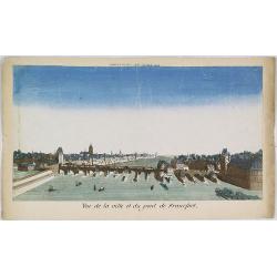
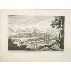
Vue de la ville et du pont de Francfort.
Showing the Medieval bridge over the river Main at Frankfurt am Main. J. Chereau was a publisher of optical prints, established in Paris, rue St.Jacques.In the eighteenth...
Date: Paris, ca. 1750
Selling price: ????
Please login to see price!
Sold in 2010
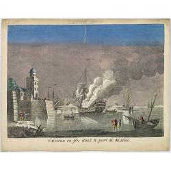
Vaisseau en feu dans le port de Messine.
Showing a fanciful depiction of the harbor of Messina on the island of Sicily and a burning vessel. J. Chereau was a publisher of optical prints, established in Paris, ru...
Date: Paris, ca. 1750
Selling price: ????
Please login to see price!
Sold in 2010

Intérieur de la Basilique de Saint Pierre.
Showing the Papal Basilica of Saint Peter, officially known in Italian as the Basilica Papale di San Pietro in Vaticano in Rome. J. Chereau was a publisher of optical pri...
Date: Paris, ca. 1750
Selling price: ????
Please login to see price!
Sold in 2013
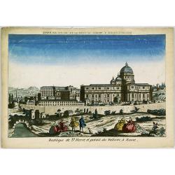
Basilique de St.Pierre et Palais du Vatican à Rome.
Showing the Papal Basilica of Saint Peter, and the Papal Palace in Vatican in Rome. J. Chereau was a publisher of optical prints, established in Paris, rue St.Jacques.In ...
Date: Paris, ca. 1750
Selling price: ????
Please login to see price!
Sold in 2013
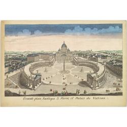
Grande place, Basilique S. Pierre et Palais du Vatican.
Showing the Papal Basilica of Saint Peter, and its square in the Vatican in Rome. J. Chereau was a publisher of optical prints, established in Paris, rue St.Jacques.In th...
Date: Paris, ca. 1750
Selling price: ????
Please login to see price!
Sold in 2013
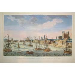
Vue Perspective...Ville de Londres prise de la Temise
A "vue optique" view of London on the River Thames. Major monuments are depicted, including the Tower of London, St. James and Westminster Bridge. Numerous mari...
Date: Paris, ca. 1750
Selling price: ????
Please login to see price!
Sold in 2010
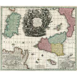
Siciliae Regnum cum adjacente Insula Sardinia et maxima parte Regni Neapolitani.
Map of Sicily, Sardinia, Malta and parts of Corsica, South Italy and North Africa. Inset map of Messina and Cartana.
Date: Augsburg, 1750
Selling price: ????
Please login to see price!
Sold in 2010
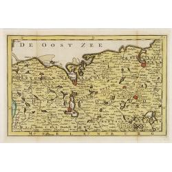
Hertogdom Meklenburg aan de Oostzee.
Uncommon and detailed map of Mecklenburg, including the towns of Rostock, Wismar Swerin and Gustrow. Included in "Zak en reis Atlas van Duitsland". Engraved by ...
Date: Amsterdam, N.T. Gravius, 1750
Selling price: ????
Please login to see price!
Sold in 2017
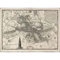
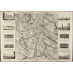
A Plan of the City of Coventry Surveyed in MDCCXLVIII & IX by Samuel Bradford and Engraved by Thos. Jefferys
Rare and important plan of Coventry by T. Jefferys.A large and detailed plan of Coventry, engraved and published by Thomas Jefferys in 1750 after a survey of Samuel Bradf...
Date: London, 1750
Selling price: ????
Please login to see price!
Sold in 2010
A Plan of the City of York Survey'd By Peter Chassereau / Plan de la Ville et foubourgs de York. Capitale de le Comté du meme Nom levé par le Sr. P: Chassereau & Publié par Rocque a Charing Cross 1750
Rare plan of York by J. RocqueA large and detailed copper engraved plan of York, published by John Rocque in 1750 after a survey of Peter Chassereau. Surrounded by 10 ins...
Date: London, 1750
Selling price: ????
Please login to see price!
Sold in 2010
A Survey of the City and Suburbs of Bristol Survey'd by John Rocque Land Surveyor at Charing Cross, 1750 / Plan de la Ville et Faubourgs de Bristol Leve par Jean Rocque a Charing Cross a Londres 1750
Rare map of Bristol by J. RocqueA large and detailed copper engraved map of the city and suburbs of Bristol, draw, serveyed and published by John Rocque in 1750. Surround...
Date: London, 1750
Selling price: ????
Please login to see price!
Sold in 2010
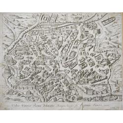
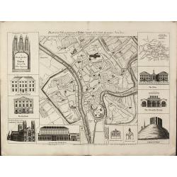
URBIS VETERIS ROMAE DELINEATIO...
Nice engraved bird's-eye plan view of ancient Rome with great detail of the buildings, streets, and monuments... Very decorative engraving by P. Philip. Rare to appear o...
Date: ca. 1750
Selling price: ????
Please login to see price!
Sold in 2010