Browse Listings in Asia
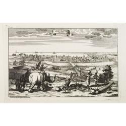
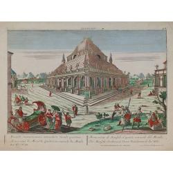
Prospect der Stadt Masulipatam in Ost=Indien.
A rare view of the town of Masulipatam in India. Many locals and elephants in the foreground.
Date: Nurnberg 1770
Selling price: ????
Please login to see price!
Sold
![[2 maps] Carte des Nouvelles découvertes.. / Extrait d'une Carte Japonaise de l'Univers..](/uploads/cache/23658-250x250.jpg)
[2 maps] Carte des Nouvelles découvertes.. / Extrait d'une Carte Japonaise de l'Univers..
Two maps on one sheet. In both maps there are texts a.o. by Kaempfer who refers to voyages made by Japanese seafarers in that region. The map is from Diderot's Encycloped...
Date: Paris, 1770
Selling price: ????
Please login to see price!
Sold
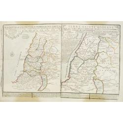
Descriptio Acurata Terrae Promissae Per Sortes XII.. & Terre Sainte Moderne.
2 maps on 1 sheet. To the left a very attractive map of Palestine divided among the 12 Tribes on both sides of the Jordan, after Philippe de La Rue. At the right hand sid...
Date: Paris, 1770
Selling price: ????
Please login to see price!
Sold in 2013
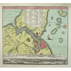
Plan von Constantinopel, mit der umliegenden Gegend, und des Canals vom Schwarzen Meer.
Engraved plan of Constantinople and environs with a extensive key to 75 of the most important buildings in town.A decorative handcolored map of Constantinople, Bosporus, ...
Date: Augsburg, 1770
Selling price: ????
Please login to see price!
Sold in 2009
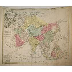
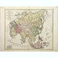
Asia Concinnata Secundum Observationes Academiae Regalis ...
Map of Asia.
Date: Augsburg, c.1770
Selling price: ????
Please login to see price!
Sold in 2009
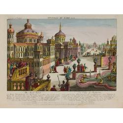
Mausolée.
In the eighteenth and nineteenth centuries there were many popular speciality establishments in Paris, Augsburg and London which produced optical viewing devices and spec...
Date: Augsburg 1770
Selling price: ????
Please login to see price!
Sold in 2010
La ville de Babylone.
In the eighteenth and nineteenth centuries there were many popular speciality establishments in Paris, Augsburg and London which produced optical viewing devices and spec...
Date: Augsburg 1770
Selling price: ????
Please login to see price!
Sold in 2010
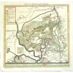
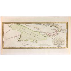
Carte du District de Tranquebar.
A detailed map of Tharangambadi,(Tranquebar & vicinity) an early trading colony controlled by Denmark. It is in the current Indian state of Tamil Nadu on the Coromand...
Date: Amsterdam, 1770
Selling price: ????
Please login to see price!
Sold in 2015
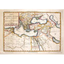
Carte de L'Empire Ottoman Dans Son Etat Actuel.
Fine detailed copper engraved map of the Ottoman Empire in its actual state surrounding the area that is Turkey today. Block cartouche. Louis Brion de la Tour (1756-1823...
Date: Paris, 1770
Selling price: ????
Please login to see price!
Sold in 2015
Carte de la Partie Superieure de l' Inde en deça du Gange.
Rigobert Bonne (1727-1795), French cartographer. His maps are found in a.o. Atlas Moderne (1762), Raynal's Histoire Philos. du Commerce des Indes (1774) and Atlas Encyclo...
Date: Paris, c. 1770
Selling price: ????
Please login to see price!
Sold in 2020
![La Destruction de la flotte ottomanne par l'escadre russe sous les ordres de S.E. Mr le comte Orlow. Dans le port de Chisme la nuit du 7m juillet 1770 [together with] (Map of Bay between Cesme and Cios)](/uploads/cache/35506-250x250.jpg)
La Destruction de la flotte ottomanne par l'escadre russe sous les ordres de S.E. Mr le comte Orlow. Dans le port de Chisme la nuit du 7m juillet 1770 [together with] (Map of Bay between Cesme and Cios)
Very rare separately published print showing the siege of Cesme on 7th July 1770. The battle took place during the Russian Turkish war of 1768-1774 at Cesme, near Izmir i...
Date: Paris, after 1770
Selling price: ????
Please login to see price!
Sold in 2015
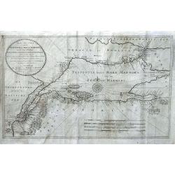
Nieuwe Zee-Caart van de Propontis of Zee van Marmora, met de Twee Straaten Hellespont en t Naauw van Constantinopolen... P.D. Bohn 1770...
Very rare chart depicting the Sea of Marmora and the surrounding regions, including Constantinopel, Hellespont, the Dardeanelle Strait, part of Turkey and Greece. chart i...
Date: Amsterdam, 1770
Selling price: ????
Please login to see price!
Sold in 2016
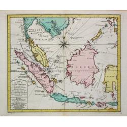
Insularum Indicaru & Terrae Australis necdum fatis derectae Repraesentatio Geographica.
The map shows whole South-East Asia with partial Australia which only on the north-west coast was discovered.Read more Early maps of South East Asia [+]
Date: 1770
Selling price: ????
Please login to see price!
Sold in 2021
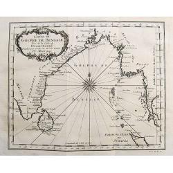
Carte du Golphe de Bengale...
Nice chart of the Bay of Bengal. The map extends from Malabar to Sumatra and today Phuket area in Thailand. Including Pegu, Ceylon, and the Andaman and Nicobar Islands. N...
Date: Paris, ca. 1770
Selling price: ????
Please login to see price!
Sold in 2017
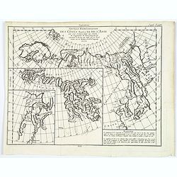
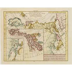
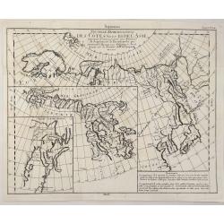
Nouvelle representation des cotes nord et est de l'Asie. . .
Three maps on one sheet. Depicting three maps centered on mainland China, Hokkaido and Kamtschadka in three different visions.Korea and Quelpaerts indicated, but no town....
Date: Paris, 1770
Selling price: ????
Please login to see price!
Sold in 2017
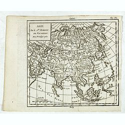
Asie.
Map of Asia. The map is of interest for the use of East Sea, the sea between Korea and Japan, here called "M. de Coree".
Date: Paris, 1770
Selling price: ????
Please login to see price!
Sold in 2017
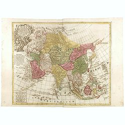
Asia Concinnata Secundum Observationes Academiae Regalis . . .
A version of De L'Isle's map. T.C. Lotter married M. Seutter's daughter in 1740 and succeeded him in 1756. Lotter used the copperplate of Seutter, he only changed the nam...
Date: Augsburg, ca. 1770
Selling price: ????
Please login to see price!
Sold in 2025
![Carte des Isles du Japon et la Presqu Isle de Coree ... [Schley]](/uploads/cache/84450-250x250.jpg)
Carte des Isles du Japon et la Presqu Isle de Coree ... [Schley]
Map of Japan and Korea, with Taiwan and Chinese cities: Pekin, Canton and Nankin. From the rarer dutch edition by Schley "Origin: Histoire Générale des voyages, ou...
Date: Amsterdam, ca. 1770
Selling price: ????
Please login to see price!
Sold in 2021
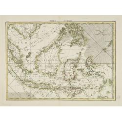
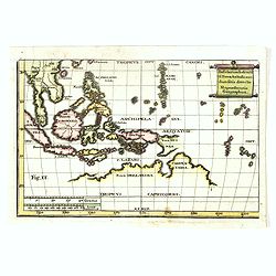
Indes IVe Feulle
A detailed map showing Indonesia, Philippines and New Guinea.
Date: Paris, 1771
Selling price: ????
Please login to see price!
Sold in 2019
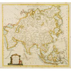
Asia drawn and engraved from the best maps & chart.
Fine map of the continent of Asia.
Date: London 1771
Selling price: ????
Please login to see price!
Sold
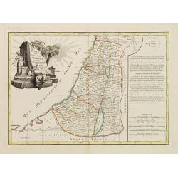
Carte des douze tribus d'Israel..
A finely engraved map depicting the division of the Holy Land into twelve tribes after Bonne.
Date: Paris, 1771
Selling price: ????
Please login to see price!
Sold in 2014
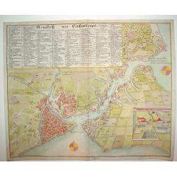
Grundrik Von Constantinopel
An uncommon and superbly engraved plan of Constantinople. There is a charming inset of the Sultan's Palace in the lower right section of the plate. In the upper portion o...
Date: Hamburg, ca. 1771
Selling price: ????
Please login to see price!
Sold
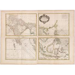
Carte Hydro-geo-graphique des Indes Orientales.. (Set of Four Maps)
A detailed map with a large, and very decorative title cartouche, showing the coast of southern China, Taiwan and the northern Philippines region with particular detail i...
Date: Paris 1771
Selling price: ????
Please login to see price!
Sold in 2014
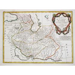
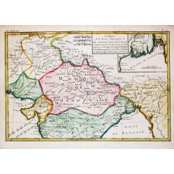
Carte de l\' Empire de Perse.
Jean Lattré, Paris-based engraver and publisher. Worked with Robert de Vaugondy, J. Janvier and R. Bonne. " Atlas Monderne', 1771, 1783 , 1793. Rigobert Bonne, Fren...
Date: Paris, 1771
Selling price: ????
Please login to see price!
Sold in 2010
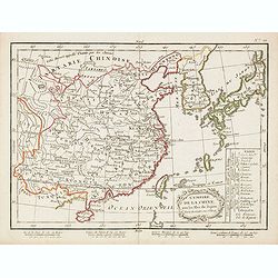
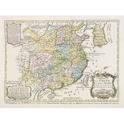
L'Empire de la Chine avec les isles du Japon.
Uncommon map of China, Japan, Korea and Taiwan. In lower right division of Chinese provinces. In bottom 4 scales.
Date: Paris / Bordeaux, 1771
Selling price: ????
Please login to see price!
Sold in 2015
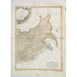
Partie Orientale de l 'Empire de Russie. . .
A striking map of western Russia. Includes Tartarian Russia with Siberia and the Bering Strait, and from the Arctic Ocean to the Caspian Sea, Sakhalin and Kamchatka. The ...
Date: Paris, 1771
Selling price: ????
Please login to see price!
Sold in 2021
![[4 sheet map] Carte Hydro-geo-graphique des Indes Orientales . . .](/uploads/cache/41388-250x250.jpg)
[4 sheet map] Carte Hydro-geo-graphique des Indes Orientales . . .
A detailed map with a large, decorative title cartouche, showing from India east to the Philippines, Borneo, Java, the Celebes, and Timor and Formosa. Marked across areas...
Date: Paris, 1771
Selling price: ????
Please login to see price!
Sold in 2020
![Turcia Asiatica exhibens Natoliam Modernam [shows Cyprus].](/uploads/cache/83655-250x250.jpg)
Turcia Asiatica exhibens Natoliam Modernam [shows Cyprus].
A beautifully colored, regional map, extending from Cyprus and Greece in the west to the Caspian Sea in the East and centered on Asia Minor, Aremenia, Iraq and Turkey. A ...
Date: Nuremberg, 1771
Selling price: ????
Please login to see price!
Sold in 2020
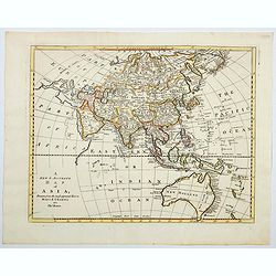
A new & accurate map of Asia, drawn from the most approved Modern Maps & Charts.
An excellent engraving of Asia. The map renders the entire continent in excellent detail with mountains, rivers, lake and forests. The map is of interest for the use of S...
Date: London, ca 1771
Selling price: ????
Please login to see price!
Sold in 2023
Des Côtes Nord et Est de L'Asie..
Three maps on one sheet, showing the north eastern coast line of China with Kamchatka. Prepared by Robert de Vaugondy. From his Encyclopedia.
Date: Paris, 1772
Selling price: ????
Please login to see price!
Sold in 2012
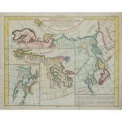
Nouvelle Représentation Des Côtes Nord Et Est De L'Asie ...
Three maps on one sheet, showing the north eastern coast line of China with Kamtschatka. From Diderot's Encyclopedie.
Date: Paris, 1772
Selling price: ????
Please login to see price!
Sold in 2011
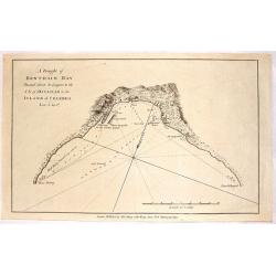
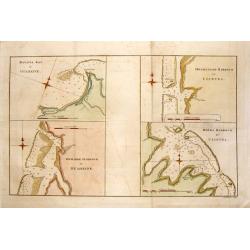
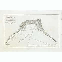
A Draught of Bonthain Bay Situated About 30 Leagues to the S.E. of Macassar in the Island of Celebes.
Interesting copper engraved nautical chart featuring the Bantaeng Region of Indonesia.< Relief shown pictorially and by hachures with depths by soundings.
Date: London, 1772
Selling price: ????
Please login to see price!
Sold in 2016
A Draught of Bonthain Bay.
A fine map of Bonthian Bay on the Island of Sulawesi, in Indonesia. The bay is about 30 leagues to the southeast of Macassar.
Date: Paris, 1772
Selling price: ????
Please login to see price!
Sold in 2015
Asia secundum novas celeberrimi de l'Isle Projectiones aliorumque. . .
A pleasant map of the continent of Asia, with each country displayed in a different color. Plain oval title cartouche. A set of 5 different mileage scales lower left corn...
Date: Augsburg, 1772
Selling price: ????
Please login to see price!
Sold in 2017
Nouvelle Representation des Cotes Nord et Est de l'Asia.
A map of the north and east coast of Asia, showing an oddly shaped Japan and inset maps of Kamchatka. It originates from: 'The Encyclopédie ou Dictionnaire Raisonné des...
Date: Paris, 1772
Selling price: ????
Please login to see price!
Sold in 2023
L'Empire de La Chine pour servir a l'histoire des etablissemens europees ..
Attractive map of China with Canton, Nanking and Taiwan, called Isle Tay-wan, ou de Formosa.The map is of interest for the use of East Sea, the sea between Korea and Japa...
Date: The Hague, 1773
Selling price: ????
Please login to see price!
Sold
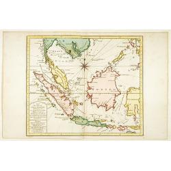
Carte des Isles de Java Sumatra et Borneo..
A very fine map centered on the islands of Java, Sumatra, Borneo and Malay Peninsular.With French text in title cartouche and an additional title in Dutch below.
Date: Amsterdam 1773
Selling price: ????
Please login to see price!
Sold
Nouvelle carte de l'Isle de Java.
A very nice map centered on the island of Java.With French text in title cartouche and an additional title in Dutch underneath the map.
Date: Amsterdam 1773
Selling price: ????
Please login to see price!
Sold
Carte des Isles du Japon.. Coree, Avec .. De la Chine..
Uncommon map of Japan, Korea, Taiwan and the south east coast of China from Peking till Macao. After J.N.Bellin, with title in Dutch in lower margin, engraved by J.van Sc...
Date: Amsterdam 1773
Selling price: ????
Please login to see price!
Sold
Carte de la Tartarie Occidentale.
Jaques Nicolas Bellin (1702-720) was the most important French hydrographer of the 18th century. Sea-atlas 'Hydrographique Français' , 1756-65, atlas to accompany Prévo...
Date: Amsterdam, 1773
Selling price: ????
Please login to see price!
Sold in 2009
Carte de l' Indoustan...
Nicolas Bellin's map of Pakistan and northern India. Uncommon Dutch issue, with text in French and Dutch. Engraved by J.van Schley. From "Atlas Portatif pour servir ...
Date: The Hague, 1773
Selling price: ????
Please login to see price!
Sold in 2020
Carte des Isles de Java, Sumatra Borneo & Les Détroits de la Sonde Malaca et Banca Golphe de Siam.
Jaques Nicolas Bellin (1702-720) was the most important French hydrographer of the 18th century. Sea-atlas 'Hydrographique Français' , 1756-65, atlas to accompany Prévo...
Date: Amsterdam, 1773
Selling price: ????
Please login to see price!
Sold in 2016
Carte de la Tartarie Occidentale.
Jaques Nicolas Bellin (1702-720) was the most important French hydrographer of the 18th century. Sea-atlas 'Hydrographique Français' , 1756-65, atlas to accompany Prévo...
Date: Amsterdam, 1773
Selling price: ????
Please login to see price!
Sold in 2009
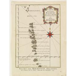
Carte des isles Maldives.
Jaques Nicolas Bellin (1702-720) was the most important French hydrographer of the 18th century. Sea-atlas 'Hydrographique Français' , 1756-65, atlas to accompany Prévo...
Date: Amsterdam, 1773
Selling price: ????
Please login to see price!
Sold
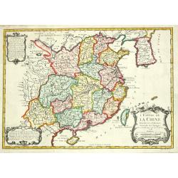
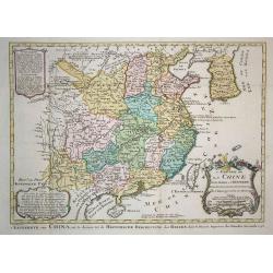
L' Empire de la Chine, 1748.
Jaques Nicolas Bellin (1702-720) was the most important French hydrographer of the 18th century. Sea-atlas 'Hydrographique Français' , 1756-65, atlas to accompany Prévo...
Date: Amsterdam, 1773
Selling price: ????
Please login to see price!
Sold
L'Empire de La Chine../ 't Keizerryk van China..
Attractive map of China with Korea and Taiwan (I.Tay-wan, ou Formosa). Decorative title cartouches in three corners.From Atlas Portatif pour servir a l'intelligence de l'...
Date: Amsterdam 1773
Selling price: ????
Please login to see price!
Sold
Carte des Costes de Perse, Guzarat et Malabar.
Jaques Nicolas Bellin (1702-720) was the most important French hydrographer of the 18th century. Sea-atlas 'Hydrographique Français' , 1756-65, atlas to accompany Prévo...
Date: Amsterdam, 1773
Selling price: ????
Please login to see price!
Sold in 2018
Carte de L'Indoustan. . .
Uncommon edition of this fine map of the northern part of India. In lower right engraved "4a"From Atlas Portatif pour servir a l'intelligence de l'Histoire Phil...
Date: Amsterdam, 1773
Selling price: ????
Please login to see price!
Sold in 2013
Carte de L'Isle de Ceylan. Pour servir à l'histoire. . .
Uncommon edition of this fine map of Shri Lanka. In lower right engraved "6."From Atlas Portatif pour servir a l'intelligence de l'Histoire Philosophique et Pol...
Date: Amsterdam, 1773
Selling price: ????
Please login to see price!
Sold in 2020
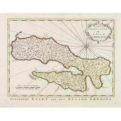
Carte Particuliére de L'Isle d'Amboine.
Uncommon edition of this detailed close-up of this Indonesian island Ambon, only infrequently encountered in this manner.With a pleasing title cartouche and 10. engraved ...
Date: Amsterdam, 1773
Selling price: ????
Please login to see price!
Sold in 2013
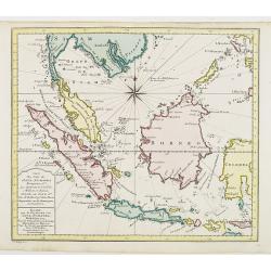
Carte des Isles de Java Sumatra et Borneo..
A very fine map centered on the islands of Java, Sumatra, Borneo and Malay Peninsular.From Atlas Portatif pour servir a l'intelligence de l'Histoire Philosophique et Poli...
Date: Amsterdam, 1773
Selling price: ????
Please login to see price!
Sold in 2012
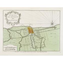
Carte Des Environs de Batavia.
Uncommon edition of this fine plan of Batavia, head quarters of the V.O.C. In lower right engraved 13.From Atlas Portatif pour servir a l'intelligence de l'Histoire Philo...
Date: Amsterdam, 1773
Selling price: ????
Please login to see price!
Sold in 2013
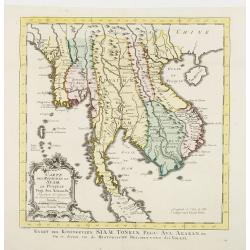
Carte Des Royaumes de Siam, de Runquin, Pegu. Ava..
Uncommon edition of this fine map incorporating information provided by French Jesuits, of Indochina, Malayan peninsular, Thailand, etc.From Atlas Portatif pour servir a ...
Date: Amsterdam, 1773
Selling price: ????
Please login to see price!
Sold
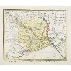
Nouvelle carte du Royaume de Bengale.
Uncommon issue of this detailed map of Bangladesh with the Ganges delta, including Calcutta. Giving great detail with trade routes, European trade settlements, etc.Prepar...
Date: Amsterdam, 1773
Selling price: ????
Please login to see price!
Sold
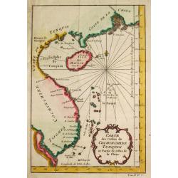
Carte des Costes de Cochin Chine, Tunquin et Partie de celles de la Chine.
Jaques Nicolas Bellin (1702-720) was the most important French hydrographer of the 18th century. Sea-atlas 'Hydrographique Français' , 1756-65, atlas to accompany Prévo...
Date: Amsterdam, 1773
Selling price: ????
Please login to see price!
Sold
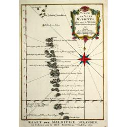
Carte des isles Maldives.
A map of the Maldive Islands. Jacques Nicolas Bellin (1702-720) was the most important French hydrographer of the 18th century. He published a sea-atlas "Hydrographi...
Date: Amsterdam, 1773
Selling price: ????
Please login to see price!
Sold in 2017
L'Empire de la Chine Pour Servir a l'Histoire des Etablissemens Europeens. Orbis terrarum
Attractive and detailed map of China and Korea, with Canton, Nanking and Taiwan. Taiwan is called Isle Tay-wan, ou de Formosa. The Sea of Japan is labeled Mer de Coree. T...
Date: Amsterdam, 1773
Selling price: ????
Please login to see price!
Sold in 2009
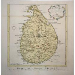
Carte de l'Isle de Ceylan
Detailed copper engraved map of the island with good detail inland of mountains, rivers, towns and villages. Rococo-style cartouche and a simple compass rose accent the m...
Date: Amsterdam, 1773
Selling price: ????
Please login to see price!
Sold in 2009
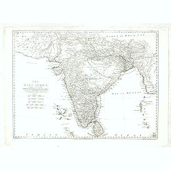
The East Indies including more particularly the British Dominions on the Continent of India...
Very detailed map of India with Ceylon. Extends to include the Maledives, Andaman Islands, Tibet, Pegu, and a tiny part of Sumatra. Engraved by Thomas Kitchin.
Date: London, 1773
Selling price: ????
Please login to see price!
Sold in 2013
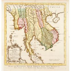
Carte Des Royaumes de Siam, de Runquin, Pegu. Ava. . .
Uncommon edition of this fine map incorporating information provided by French Jesuits, of Indochina, Malayan peninsular, Thailand, etc.From Atlas Portatif pour servir a ...
Date: Amsterdam, 1773
Selling price: ????
Please login to see price!
Sold in 2021
4 Nautical Charts in One - Matavia Bay in Otaheite etc.
This striking map is made up of four nautical charts including: - Matavia Bay in Otaheite, - Ohamaneno Harbour in Ulietea, - Owharre Harbour in Houheine & - Oopoah Ha...
Date: London, 1773
Selling price: ????
Please login to see price!
Sold in 2020
A Draught of Bonthain Bay situated about 30 Leagues to the S E of Macassar in the Island of Celebes. . .
Bonthain Bay at the island of Sulawesi [i.e. Celebes]. The bay is about 30 leagues to the southeast of Macassar. Large amount of detail in the bay including the location ...
Date: London, W. Strahan and T. Cadell, 1773
Selling price: ????
Please login to see price!
Sold in 2022
A Chart of Captain Carteret's Discoveries at New Britain, with Part of Captain Cook's Passage Thro Endeavour Streights, & of Captain Dampier's Tract & Discoveries in 1699, & 1700, at New Guinea & New Britain
This fine chart of Papua New Guinea shows the new discoveries of Captains Cook, Carteret, and Dampier along New Guinea, New Britain, and New Ireland. The chart details th...
Date: London, 1773
Selling price: ????
Please login to see price!
Sold in 2018
The East Indies . . .
Highly detailed map of India and Sri Lanka, drawn by Thomas Kitchin and published in the London Magazine. Cities, towns and geographical features are all shown.
Date: London, 1773
Selling price: ????
Please login to see price!
Sold in 2018
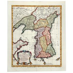
CARTE DE LA PROVINCE de Quan-tong ou Lyau-tong et du ROYAUME DE KAU-LI ou COREE (Korea).
An uncommon issue of this fine map of Korea. The map is of interest for the use of East Sea, the sea between Korea and Japan, here called "Mer de Corée". With ...
Date: Paris, 1749-1773
Selling price: ????
Please login to see price!
Sold in 2019
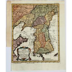
Carte de la Province de Quantong ou Lyau tong et du Royaume de KAU-LI ou COREE
Uncommon issue of this fine map of Korea. The map is of interest for the use of East Sea, the sea between Korea and Japan, here called "Mer de Corée.Decorative titl...
Date: Paris, 1749-1773
Selling price: ????
Please login to see price!
Sold in 2019
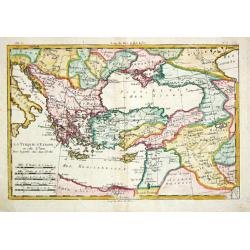
La Turquie d? Europe et celle d?Asie.
Rigobert Bonne (1727-1795), French cartographer. His maps are found in a.o. Atlas Moderne (1762), Raynal's Histoire Philos. du Commerce des Indes (1774) and Atlas Encyclo...
Date: Paris, 1774
Selling price: ????
Please login to see price!
Sold
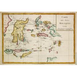
Carte des Isles Moluques.
Rigobert Bonne (1727-1795), French cartographer. His maps are found in a.o. Atlas Moderne (1762), Raynal's Histoire Philos. du Commerce des Indes (1774) and Atlas Encyclo...
Date: Paris, 1774
Selling price: ????
Please login to see price!
Sold in 2009
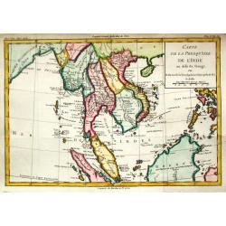
Carte de la Presque' Isle de l' Inde.
Louis Brion de la Tour (1756-1823), ' Atlas Géneral, Civil et Ecclésiastique', 1766, ' Atlas Général', 1790-98. Louis Charles Desnos (fl.1750-70), Le Rouge's 'Atlas N...
Date: Paris, 1774
Selling price: ????
Please login to see price!
Sold
Carte de la Presque' Isle de l' Inde.
A map of Indochina, Thailand, Malaysia, the Philippines and the island of Hainan. Published by Louis Brion de la Tour (1756-1823), and included in his Histoire Universel.
Date: Paris, 1774
Selling price: ????
Please login to see price!
Sold in 2015
![Banc de Sable dangereux / Isles de Jofeph Freewill / L'Extrémité Méridionale de Mindanao. [Tome I. Pl. 15.]](/uploads/cache/25899-250x250.jpg)
Banc de Sable dangereux / Isles de Jofeph Freewill / L'Extrémité Méridionale de Mindanao. [Tome I. Pl. 15.]
Three charts on one page showing the southern tip of Mindanao. This map is taken from the first French edition of James Cook's first voyage entitled Relation des voyages ...
Date: Paris, 1774
Selling price: ????
Please login to see price!
Sold in 2015
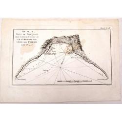
Vue de la Baye de Bonthain . . .dans l\'Isle des Celebes. Tome I Pl. 16.
Chart of Bonthain Bay on the Island of Celebes. This map is taken from the first French edition of James Cook\'s first voyage entitled Relation des voyages entrepris par ...
Date: Paris, 1774
Selling price: ????
Please login to see price!
Sold in 2008
Nieuwe en Naukeurige Kaart van het Keizerryk Japan
A rare, fine decorative map of Japan, with the cartouche on the upper left. In a very good state.The map is of interest for the use of East Sea, the sea between Korea and...
Date: Amsterdam, 1774
Selling price: ????
Please login to see price!
Sold in 2014
Nouvelle carte des mers comprises entre le détroit de Banca et P°. Timon avec la partie orientale du détroit de Malacca.
Important French of the tip of Malaysia with Singapore.Latitude and longitude scales, compass rose and system of rhumb lines, soundings near coast and in bay areas.Engra...
Date: Paris, Jean-François Robustel, 1774
Selling price: ????
Please login to see price!
Sold in 2013
A map of Chinese Tartary with Corea.
The map is of interest for the use of Coreen Sea, the sea between Korea and Japan.Detailed map of China and Korea with Jeso Gasima in the east. Including The Gobi Desert,...
Date: London, 1774
Selling price: ????
Please login to see price!
Sold in 2015
Carte des Isles Nicobar... (with) Plan particulier du Port compris entre les Isles Nacaveri, Souri, et Tricutte.
French chart of Isles of Nicobar in Gulf of Bengal near Birmanie and Sumatra. Prepared by Jacques-François L'Abbé Dicquemare (1733-1789). Latitude and longitude scales,...
Date: Paris, Brest, chez Demonville, 1775
Carte d'une partie des Côtes de la Chine et des Isles adjacentes depuis l'Isle nommée la Pierre Blanche, jusqu'à celle de l'Artimon.
Most important milestone chart based upon the surveys made from navigational surveys and soundings in 1754, 1759, and 1760 by Alexander Dalrymple. This edition of Dalrymp...
Date: Paris, ca 1775
Selling price: ????
Please login to see price!
Sold
Kaart ter opheldering der geschiedenis.. koophandel..
Attractive and uncommon map covering Asia and Australia, also the east coast of Africa. Engraved by Pieter Mol. The map is copied after Bonne, who is given credit in the ...
Date: Amsterdam 1775
Selling price: ????
Please login to see price!
Sold
Kaart van 't Eyland Amboine.
An uncommon map of the island of Ambon.
Date: Almelo, 1775
Selling price: ????
Please login to see price!
Sold in 2009

Vue du Port de la Ville de Lamekk dans Larabie heureuse à 5 lieues de la Mer Rouge.
Imaginary optic vue of Mecca's harbor.
Date: Paris 1730-1775
Selling price: ????
Please login to see price!
Sold in 2008