Browse Listings in Asia
![[Lot of 4 maps] Afbeeldinge der Oostersche Landen. / van ' T Land Kanaan.](/uploads/cache/100146-250x250.jpg)
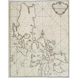
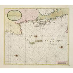
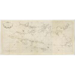
[Lot of 4 maps] Afbeeldinge der Oostersche Landen. / van ' T Land Kanaan.
Willem Albert Bachiene (1712-1783), Dutch geographer in Maastricht. Most important work ' Heilige Geographie', a work on the Holy Land. A map of the Near East and a map o...
Date: Amsterdam, c. 1750
Selling price: ????
Please login to see price!
Sold in 2022
![[Lot of 10 maps and prints of Birma, Thailand and Malaysia.]](/uploads/cache/20085-(4)-250x250.jpg)
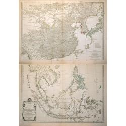
[Lot of 10 maps and prints of Birma, Thailand and Malaysia.]
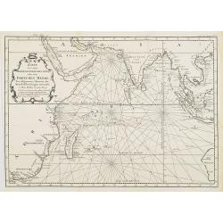
A map of the Gulf of Bengal with the adjacent coasts of India and Sri Lanka, Bangla Desh, Birma, Thailand and Malaysia. Ref.: Gole, India within the Ganges, 62.11.1Jaques...
Date: Paris, Amsterdam, c. 1750
Selling price: ????
Please login to see price!
Sold in 2022
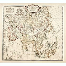
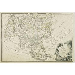
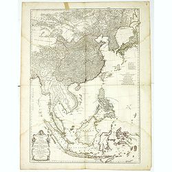
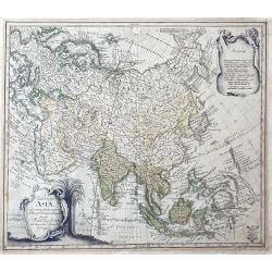
Carte de l'Asie dressé sur les relations les plus..
Standard map of Asia, with good detail.
Date: Paris, 1751
Selling price: ????
Please login to see price!
Sold
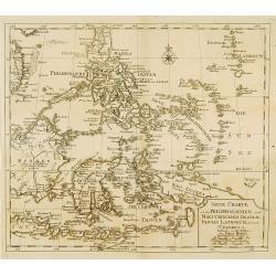
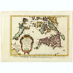
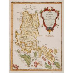
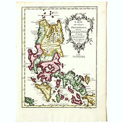
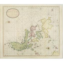
Neue Charte von dem Philippinischen und Moluckischen Insuln..
Very rare map of South East Asia including the Philippines, Moluccas, New Guinea, parts of Borneo, and Java. The map is a faithful copy of Isaac Tirion's map of a few yea...
Date: Altona, 1751
Selling price: ????
Please login to see price!
Sold
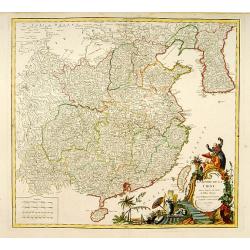
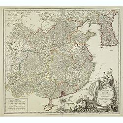
L'Empire de la Chine..
Detailed map of China, Korea and Taiwan. Decorative cartouche lower right.
Date: Paris 1751
Selling price: ????
Please login to see price!
Sold
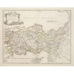
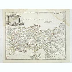
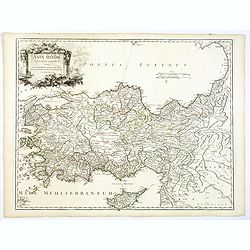
Asia Minor in suas partes seu provincias divisa..
Detailed map of Cyprus, Asia Minor and contiguous Islands and the Black Sea region.
Date: Paris 1751
Selling price: ????
Please login to see price!
Sold
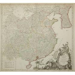
L'Empire de la Chine ...
Detailed map of China, Korea and Taiwan. Decorative cartouche lower right.
Date: Paris, 1751
Selling price: ????
Please login to see price!
Sold in 2011
Carte du Canal des Iles Philippines. . . Page 88.
Important large-scale map of the northern Philippines, from Luzon to Negros, featuring the track of the Manila Galleon on its yearly treasure voyage from Manila to Mexico...
Date: Amsterdam, 1751
Selling price: ????
Please login to see price!
Sold in 2008
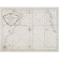
Carte de l'Ocean Meridional. . .
Map of the southern Atlantic Ocean including South America and South African coastlines. From "Voyage Autour du Monde, Fait dans les Années MDCCXL, I, II, III, IV. ...
Date: Amsterdam, 1751
Selling price: ????
Please login to see price!
Sold in 2008
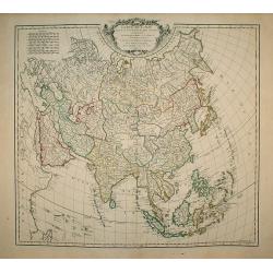
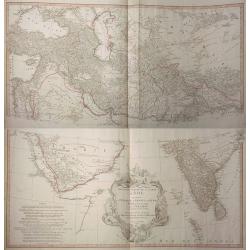
Carte de L\'Asie dressée sur les Relations les plus nouvelles principalement..
Detailed map of Asia from the Atlas Universel , first published in 1755. The map is detailed, precisely engraved and not given to the fanciful cartography being promoted ...
Date: Paris, 1751
Selling price: ????
Please login to see price!
Sold in 2010
L'ASIE divisée en ses principaux ETATS par le Sr. Janvier, G
This fine map presents a fairly accurate and modern outline of Asia. The Bering Straits are identified as Detroit du Nord ou d'Anian.The map is of interest for the use of...
Date: Paris, 1751
Selling price: ????
Please login to see price!
Sold in 2010
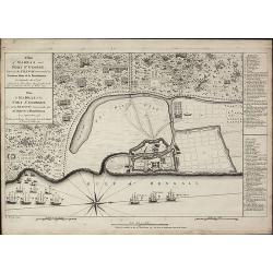
A Plan of Madras and Fort St. George, Taken by the French, Commanded by Monsieur Martre de la Bourdonnais. / Plan de Madras et du Fort St. Georges, pris parles Francois, Commandes par Mr. Matre de la Bourdonnais
A very rare plan of Madras during the Carnatic WarsThis copper engraved plan of Madra in India was published by John Rocque in 1751 and engraved by one of his employees R...
Date: London, 1751
Selling price: ????
Please login to see price!
Sold in 2010
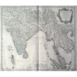
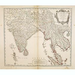
Les Indes Orientales ou sont distingues les Empires et Royaumes quelles contiennent, tirees du Neptune Oriental.
An early edition of Robert de Vaugondy's map from his Atlas Universel. Reaches from Pakistan (with Candahar and Caboul) to Sumatra and Singapore. Includes India, the Male...
Date: Paris, 1751
Selling price: ????
Please login to see price!
Sold in 2011
Asia Minor in suas partes seu provincias divisa. . .
Detailed map of Ancient Turkey with Cyprus from his "Atlas Universel".Gilles Robert de Vaugondy (1688–1766), also known as Le Sieur or Monsieur Robert, and hi...
Date: Paris, 1751
Selling price: ????
Please login to see price!
Sold in 2012
L'Empire de la Chine..
Detailed map of China, Korea and Taiwan. Decorative cartouche lower right showing natives.
Date: Paris, 1751
Selling price: ????
Please login to see price!
Sold in 2012
Les Indes Orientales, ou sount distingues les Empires et Royaumes..
Interesting regional map extending from India, the Ganges and the Maldive Islands to Hai-nan, Cochinchina, Malacca and Sumatra. Includes islands, "Sinca poura" ...
Date: Paris, 1751
Selling price: ????
Please login to see price!
Sold
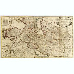
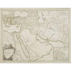
Regnum Persicum Imperium Turcicum in In Asia Russorum Provinciae ad Mare Caspium . . .
Striking map of the region bounded by Cyprus and the Eastern Mediterranean, the Nile, Medina, the Persian Gulf and the Indus River in the south and the Black Sea, Circass...
Date: Amsterdam, 1751
Selling price: ????
Please login to see price!
Sold in 2015
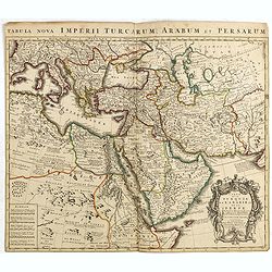
Carte de la Turquie de L'Arabie et de la Perse.
Rare early state of De L'Isle's map of the Turkish Empire and Arabian Peninsula. Includes the Turkish Empire, Mediterranean, Central Asia and parts of the Ukraine, Egypt,...
Date: Amsterdam, 1751
Selling price: ????
Please login to see price!
Sold in 2015
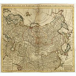
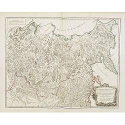
Kaert van Het geheele Russische Keizerryk...
Map of the whole Russian empire. Together with Major and Minor Tartary now enlarged with new discoveries in the year 1739 by captain Span(g)berg. Map extends from Scandin...
Date: Amsterdam, 1751
Selling price: ????
Please login to see price!
Sold in 2015
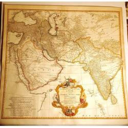
Premiere Partie de la Carte d'Asie Contenant la Turquie, l'Arabie, la Perse, l'Inde en deca du Gange et de la Tartarie
Magnificent 2-sheet map of the western half of Asia by D’Anville. Includes from Turkey through the Black and Caspian Seas to Tibet, and south to include the Arabian pen...
Date: Paris, 1751
Selling price: ????
Please login to see price!
Sold in 2015
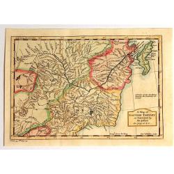
A Map of Eastern Tartary as Surveyed by the Jesuits in 1709, 1710 & 1711.
A fine map of Eastern Tartary that shows parts of present-day Russia, Mongolia, and China, and was based on the work of Jesuit cartographer Jean-Baptiste Regis.In the bot...
Date: London, 1751
Selling price: ????
Please login to see price!
Sold in 2015
Premiere Partie de la Carte d´Asie Contenant la Turquie, l´Arabie, la Perse, l´Inde en deca du Gange et de la Tartarie.
A magnificent 2-sheet map of the western half of Asia by D’Anville. Includes from Turkey through the Black and Caspian Seas to Tibet, and south to include the Arabian p...
Date: Paris, 1751
Selling price: ????
Please login to see price!
Sold in 2017
Asia Minor in suas partes seu provincias divisa. . .
A detailed map of Ancient Turkey with Cyprus from his "Atlas Universel". With s decorative title cartouche.Gilles Robert de Vaugondy (1688–1766), also known a...
Date: Paris 1751
Selling price: ????
Please login to see price!
Sold in 2019
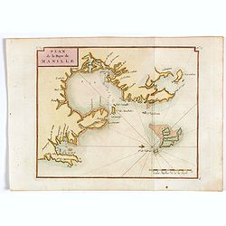
Plan de la Baye de Manille.
Detailed plan of Manila Bay after George Anson's key plan of the Bay of Manila. Several places are named along the coast, including Bataan, Metro Manila, and Cavite. With...
Date: Paris, 1751
Selling price: ????
Please login to see price!
Sold in 2018
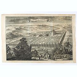
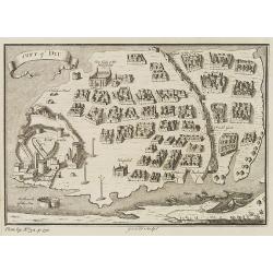
La ville de Babylone.
Eye bird view of the city of Babylone. Engraved by J.Punt. From "L'Histoire Universelle Depuis la Commencement du Monde, Jusqu'a Present, Traduit de L'Anglois D'Une ...
Date: Amsterdam, Arkstée et Merkus, 1751
Selling price: ????
Please login to see price!
Sold in 2021
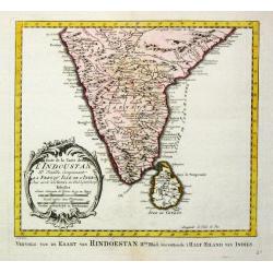
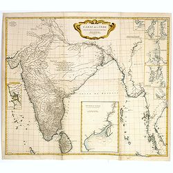
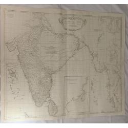
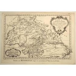
Carte de l' Indoustan IIe Feuille, comprenant la Presqu' Isle de l' Inde. 1752.
Jaques Nicolas Bellin (1702-720) was the most important French hydrographer of the 18th century. Sea-atlas 'Hydrographique Français' , 1756-65, atlas to accompany Prévo...
Date: Paris, 1752
Selling price: ????
Please login to see price!
Sold
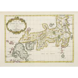
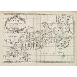
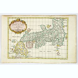
Carte de L'Empire du Japon.
A fine map of the islands of Japan embellished with fine baroque decorations.Bellin influenced other cartographers with his erroneous portrayals of Japan. This is seen in...
Date: Paris 1752
Selling price: ????
Please login to see price!
Sold
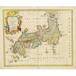
A New and Accurate Map of the Empire of Japan.
An interesting and detailed English map of the lands of Japan closely modeled on Nicolas Bellin's map of 1735.
Date: London, 1752
Selling price: ????
Please login to see price!
Sold in 2008
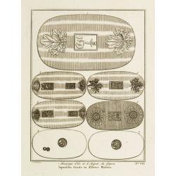
Monnoyes d'Or et d'Argent du Japon. Pl. VII.
Decorative print illustrating Golden and silver coins from Japan. From Histoire générale des voyages..> by Antoine François Prévost.Title in French and Dutch.
Date: Paris, 1752
Selling price: ????
Please login to see price!
Sold
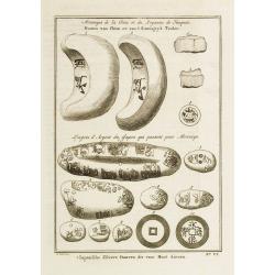
Monnoyes de la Chine et du Royaume de Tunquin. - Lingots d\'Argent du Japon qui passent pour Monnoye. Pl. VI.
Decorative print illustrating coins and silver ingots from China and Japan. From Histoire générale des voyages.. by Antoine François Prévost.Titles in French and Dutc...
Date: Paris, 1752
Selling price: ????
Please login to see price!
Sold in 2008
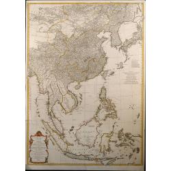
Seconde partie de la carte d'Asie contenant la Chine et partie de la Tartarie, l'Inde ... Sumatra, Java, Borneo, Moluques, Philippines et du Japon
Attractive large map of Asia from G. de la Haye by J.B.B. d'Anville. Showing southeast Asia with Japan and Korea. Printed on two plates, joined.
Date: Paris, 1752
Selling price: ????
Please login to see price!
Sold in 2009
Partie Orientale de l'Empire de Russie en Asie.
Detailed map of the north-eastern part of Russia, including Siberia.
Date: Paris, 1752
Selling price: ????
Please login to see price!
Sold in 2009
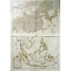
Seconde partie de la carte d\'Asie contenant la Chine et partie de la Tratarie, l\'Inde ... Sumatra, Java, Borneo, Moluques, Philippines et du Japon
Attractive large map of Asia from G. de la Haye by J.B.B. d\'Anville. Showing south east Asia with Japan and Korea. Printed on two plates
Date: Paris, 1752
Selling price: ????
Please login to see price!
Sold in 2008
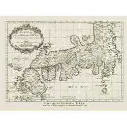
Carte de L'Empire du Japon.
A fine map of the islands of Japan embellished with fine baroque decorations.Bellin influenced other cartographers with his erroneous portrayals of Japan. This is seen in...
Date: Amsterdam, 1752
Selling price: ????
Please login to see price!
Sold in 2008
Carte de L'Empire du Japon.
A fine map of the islands of Japan embellished with fine baroque decorations. Bellin influenced other cartographers with his erroneous portrayals of Japan. This is seen i...
Date: Paris, 1752
Selling price: ????
Please login to see price!
Sold in 2008
Seconde partie de la carte d'Asie contenant la Chine et partie de la Tratarie, l'Inde . . . Sumatra, Java, Borneo, Moluques, Philippines et du Japon.
An attractive large map of Asia from G. de la Haye by J.B.B. d'Anville. Showing south east Asia with Japan and Korea. Printed on two plates.
Date: Paris, 1752
Selling price: ????
Please login to see price!
Sold in 2010
The Seraglio & Gardens of the Grand Seignior.
Rare plan of the Topkapi Palace in IstanbulThis rare plan of the Topkapi Palace in Istanbul was published by John Rocque, an English engraver, active in London from 1734....
Date: London, 1752
Selling price: ????
Please login to see price!
Sold in 2010
The Seraglio & Gardens of the Grand Seignior. / Serrail & Jardins du Grand Seigneur.
This rare plan of the Topkapi Palace in Istanbul was published by John Rocque, an English engraver, active in London from 1734. The title is printed in English and French...
Date: London, 1752
Selling price: ????
Please login to see price!
Sold
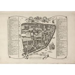
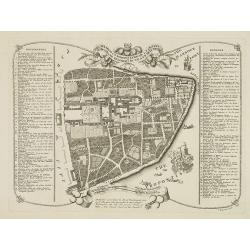
Plan de Goa. Grondtekening van Goa.
A beautifully detailed and engraved town-plan of the Portuguese colony of Goa in India, with a number key (1-29) to the city's major monuments and sites, enclosed in a de...
Date: Amsterdam, 1752
Selling price: ????
Please login to see price!
Sold in 2017
Carte Particuliere de L'Isle d'Amboine.
Fine hand-colored,copper engraved map of Ambon in the Moluccas Islands (Spice Islands)off the coast of Indonesia. After N. Bellin and engraved by Van Schley.
Date: Paris, 1752
Selling price: ????
Please login to see price!
Sold in 2018
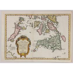
Carte des isles Philippines, dressée sur la carte espagnole du R.P. Murillo de Velarde. Ire feuille. . . 1752.
Fine map of the northern islands of the Philippines.Jacques Nicolas Bellin (1703-1772) was one of the most important and proficient French cartographers of the mid-eighte...
Date: Paris, 1752
Selling price: ????
Please login to see price!
Sold in 2021
Carte des isles Philippines, dressée sur la carte espagnole du R.P. Murillo de Velarde. Ire feuille. . .
Fine map of the northern islands of the Philippines.Jacques Nicolas Bellin (1703-1772) was one of the most important and proficient French cartographers of the mid-eighte...
Date: Paris, 1752
Selling price: ????
Please login to see price!
Sold in 2016
Carte Des Isles Philippines.. 2e. Feuille. . . / Kaart der Philippines Eilanden. . .
Detailed edition of this fine map of the southern portion of the Philippines, extending from Masbate and Oetablas Islands to Jolo Island and centered on Mindanao and Leyt...
Date: Paris, 1752
Selling price: ????
Please login to see price!
Sold in 2016
Carte de l'Inde Dressee pour la Compagnie des Indes par le Sr. d'Anville Secretaire de S.A.S.Mgr. le Duc d'Orleans Novembre 1752.
A decorative large scale map printed on four joined sheets by the renowned and influential French map maker Jean-Baptiste D'Anville. D'Anville based his cartography on Je...
Date: Paris, 1752
Selling price: ????
Please login to see price!
Sold
Carte de l' Indoustan Ie Feuille, 1752.
Jaques Nicolas Bellin (1702-720) was the most important French hydrographer of the 18th century. Sea-atlas 'Hydrographique Français', 1756-65, an atlas to accompany Pré...
Date: Paris, 1752
Selling price: ????
Please login to see price!
Sold in 2017
Cartes des Isles Philippines...
A striking map of southern part of the Philippines, based upon Pedro Murillo Velarde’s map, by the mapmaker, Nicolas Bellin in 1752 and published in Prevost’s “D' E...
Date: Paris, 1752
Selling price: ????
Please login to see price!
Sold in 2017
Carte des Isles Philippines. . .
Detailed map of the northern part of the Philippines, including Manilla.Jacques Nicolas Bellin (1703-1772) was one of the most important and proficient French cartographe...
Date: Paris, 1752
Selling price: ????
Please login to see price!
Sold in 2016
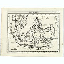
Les Indes.
A scarce small map of South East Asia with Indonesia, Thailand, Philippines and including New Guinee.
Date: Paris, ca. 1752
Selling price: ????
Please login to see price!
Sold in 2017
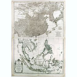
Seconde partie de la carte d'Asie contenant la Chine et partie de la Tartarie, l'Inde au-delà du Gange, les Isles Sumatra, Java, Borneo, Molusques, Philippines et du Japon.
Two-sheet map of South East Asia with very good detail of Philippines. Containing China and part of Tartary, India beyond the Ganges, Sumatra Isles, Java, Borneo, Molucca...
Date: Paris, 1752
Selling price: ????
Please login to see price!
Sold in 2023
Carte de L'Inde Dressee pour la Compagnie des Indes.
The TOP HALF ONLY of the large format map of 18th century India, published by D'Anville. This map draws from numerous sources, including Ptolemy, Turkish and Indian geogr...
Date: Paris, 1752
Selling price: ????
Please login to see price!
Sold in 2018
Seconde partie de la carte d'Asie contenant la Chine et partie de la Tartarie, l'Inde au-delà du Gange, les Isles Sumatra, Java, Borneo, Molusques, Philippines et du Japon.
A wall map size map of South East Asia with very good detail of Philippines. Containing China and part of Tartary, India beyond the Ganges, Sumatra Isles, Java, Borneo, M...
Date: Paris, 1752
Selling price: ????
Please login to see price!
Sold in 2018
Carte des Isles Philippines . . . (1ere feuille)
The northern part of the Philippines, including the town of Manila.Jacques Nicolas Bellin (1703-1772) was one of the most important and proficient French cartographers of...
Date: Paris, 1752
Selling price: ????
Please login to see price!
Sold in 2018
Carte de L'inde Dresse pour la Compagni des Indes. . .
A large map of 18th century India, published by D'Anville in 1752. It reflects the state of knowledge of this area mid-century. The map shows excellent detail of Southern...
Date: Paris, 1752
Selling price: ????
Please login to see price!
Sold in 2019
Carte de L'Empire du Japon.
A fine map of the islands of Japan embellished with fine baroque decorations.Bellin influenced other cartographers with his erroneous portrayals of Japan. This is seen in...
Date: Paris, 1752
Selling price: ????
Please login to see price!
Sold in 2020
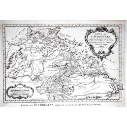
Carte de L'Indoustan Suivant les Cartes les Plus Recentes...
This pleasing map depicts the northern section of the Indian subcontinent and includes present-day Pakistan, Afghanistan, Nepal, and Tibet, in addition to northern India....
Date: Paris, 1752
Selling price: ????
Please login to see price!
Sold in 2021
Tab. Geogr. Asiae ad emendatiora,...
Scarce map of Asia also parts of Africa and Europe. With good detail and interesting names throughout. Curious shapes and some notes. Unfinished New Guinea. A banner held...
Date: Berlin, ca. 1752
Selling price: ????
Please login to see price!
Sold in 2022
Vlakke hoek van Sumatra.
Showing the part of the west coast of Sumatra with the island of Enggano. Very rare: included in 6th volume, so-called secret atlas of the V.O.C. of Van Keulen. Latitude ...
Date: Amsterdam 1753
Selling price: ????
Please login to see price!
Sold
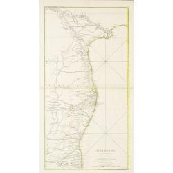
COROMANDEL.
A large map showing the east coast of the Indian peninsular.
Date: Paris, 1753
Selling price: ????
Please login to see price!
Sold in 2022
Afteekening van een gedeelte van de kust van Arracam, Pegu en Siam van de rivier Arracam, tot aan de Noordhoek van 't Eyland Sumatra.
Very rare chart of the Andaman Sea and Strait of Malacca. East to the top. In the top the town of Pegu in Miyanmar is shown, than the chart follows the coast of Thailand ...
Date: Amsterdam 1753
Selling price: ????
Please login to see price!
Sold
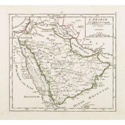
L'Arabie Par le Sr. Robert de Vaugondy.
Covering the Arabian Peninsula here called Arabie Heureuse . With title in upper left corner, the date 1748 erased. From his Atlas Portatif .
Date: Paris 1753
Selling price: ????
Please login to see price!
Sold
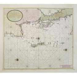
![Nieuwe Caart [..] van Banca langs [..] Malacca, Siam, Cambodia, Conchinchina](/uploads/cache/23814-250x250.jpg)
Nieuwe Caart [..] van Banca langs [..] Malacca, Siam, Cambodia, Conchinchina
A finely engraved and detailed chart of Malacca, with Singapore, Cambodia, Thailand and part of Borneo, Philippines, and many other islands in the South China Sea.Very ra...
Date: Amsterdam, 1753
Selling price: ????
Please login to see price!
Sold in 2008
![Pas=Kaart van de Vaarweg van Straat BANCA [?] en SINCAPOERA ..](/uploads/cache/23815-250x250.jpg)
Pas=Kaart van de Vaarweg van Straat BANCA [?] en SINCAPOERA ..
A finely engraved and detailed chart of southern tip of Malacca, with Singapore.Very rare: only included in 6th volume (so-called secret atlas) of Van Keulen's. Latitude ...
Date: Amsterdam 1753
Selling price: ????
Please login to see price!
Sold
Nieuwe Afteekening van de PHILIPPYNSE EYLANDEN geleegen in de Oost-Indische Zee tusschen Formosa en Borneo.
A finely engraved and detailed chart of the Philippines.Very rare: only included in 6th volume (so-called secret atlas) of Van Keulen's. Latitude scale, compass rose and ...
Date: Amsterdam, 1753
Selling price: ????
Please login to see price!
Sold in 2008
![[2 charts] Nieuwe aftekening van de Baay MANILLA in de Oostindische Zee.. / Kaart van de baay van Bongo onder 't Eilandt MINDANO..](/uploads/cache/23817-250x250.jpg)
[2 charts] Nieuwe aftekening van de Baay MANILLA in de Oostindische Zee.. / Kaart van de baay van Bongo onder 't Eilandt MINDANO..
Two finely engraved and detailed charts of the Bay of Manila and the coast of Mindanao with the island Bongo.Very rare: only included in 6th volume (so-called secret atla...
Date: Amsterdam 1753
Selling price: ????
Please login to see price!
Sold in 2009
![Nieuwe Pas=Caart strekkende van Pta Cataon tot Pta. Lamtoan, langs de kusten van Cochinchina, Tonquin, Quangsi en Quantung [?] van Macao.](/uploads/cache/23818-250x250.jpg)
Nieuwe Pas=Caart strekkende van Pta Cataon tot Pta. Lamtoan, langs de kusten van Cochinchina, Tonquin, Quangsi en Quantung [?] van Macao.
A finely engraved and detailed chart of Vietnam reaching till Macao and present-day Hong Kong..Very rare: only included in 6th volume (so-called secret atlas) of Van Keul...
Date: Amsterdam 1753
Selling price: ????
Please login to see price!
Sold
![[2 charts] Kaart van Pulo Condor, of het Eiland Condor.. / Paskaart van de Baay van Padaran op de Kust van Tsiompa..](/uploads/cache/23819-250x250.jpg)
[2 charts] Kaart van Pulo Condor, of het Eiland Condor.. / Paskaart van de Baay van Padaran op de Kust van Tsiompa..
Two finely engraved and detailed charts of Condor Island and the Bay of Pandaran.Very rare: only included in 6th volume (so-called secret atlas) of Van Keulen's. Latitude...
Date: Amsterdam, 1753
Selling price: ????
Please login to see price!
Sold in 2013
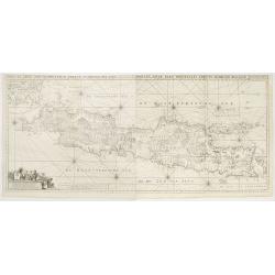
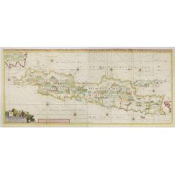
Insulae Iava Pars Occidentalis Edente Hadriano Relando..
Rare first state of this finely engraved and detailed map of Java important for its Dutch trading connections - annotated panels, clearly indicated rice fields, mountains...
Date: Amsterdam 1753
Selling price: ????
Please login to see price!
Sold
Zee-Caart van het Eyland Sumatra Met de Straaten Malacca, Sincapoera, Banca en Sunda..
A rare and finely engraved and detailed chart of Sumatra important for its Dutch trading connections. In upper right corner a detailed depiction of southern tip of Malays...
Date: Amsterdam 1753
Selling price: ????
Please login to see price!
Sold
Antiquor? Imperiorum.. Marcedonium seu Alexandri..
Including the Arabian Peninsula here called Arabia Deserta. Good detail in Turkey and Egypt.Large inset shows northern India from the Indus River and the region of the As...
Date: Paris, 1753
Selling price: ????
Please login to see price!
Sold
Insulae Java Pars Occidentalis Edente Hadriano Relando. . .
Very rare first state of this finely engraved and detailed map of Java important for its Dutch trading connections - annotated panels, clearly indicated rice fields, moun...
Date: Amsterdam, 1753
Selling price: ????
Please login to see price!
Sold in 2009
City of DIU.
Decorative town plan of Diu, after Joan Nieuhof. Engraved by G.Child for 'The Universal Traveller', by Thomas Salmon.
Date: London, Th. Salmon, 1729-1753
Selling price: ????
Please login to see price!
Sold in 2010
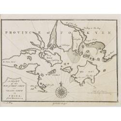
PROVINCE OF FOKYEN A chart of the Bay of Chin-Chew or Chang-Chew in China.
A small but very early and interesting map, engraved by G.Child for \'The Universal Traveller\', by Thomas Salmon.Covers that part of the coastline from Pu-tay Point, dow...
Date: London, Th. Salmon, 1729-1753
Selling price: ????
Please login to see price!
Sold in 2008
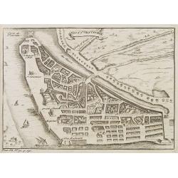
Plan of ye City of Cochin.
A small but very early and interesting town plan of Cochin, engraved by G.Child for 'The Universal Traveler', by Thomas Salmon.
Date: London, Th. Salmon, 1729-1753
Selling price: ????
Please login to see price!
Sold in 2012
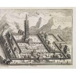
Temple of Paulin near Nankin.
A small but very early and interesting engraving by J. Basire for 'The Universal Traveller', by Thomas Salmon. A pleasing and uncommon mid-18th century birds-eye view (li...
Date: London, Th. Salmon, 1729-1753
Selling price: ????
Please login to see price!
Sold in 2008
Partie Méridionale de la Russie Européenne . . .
Detailed map of Ukraine, the Crimea and the northern part of the Caspian Sea.
Date: Paris, 1753
Selling price: ????
Please login to see price!
Sold in 2009
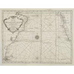
Karte von dem mittaeglichen Meere, zu der allgemeinen Historie der Reise beschreibungen entworfen von Hrn Bellin..
Detailed map of the Indian Ocean depicting incomplete coastline for Western Australia marked with "See hunden Bay" and "I.des Filles". Reaching in the...
Date: Leipzig, 1753
Selling price: ????
Please login to see price!
Sold in 2008
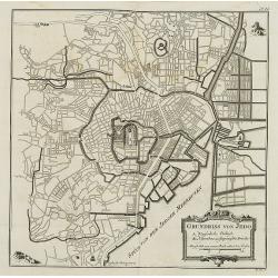
Grundriss von Jedo. . . N°24
City plan of the Emperor\'s Palace and the town of Jedo, Tokyo, Japan with a key to important buildings and bridges. In: Allgemeine Historie der Reisen zur Wasser und zu ...
Date: Leipzig, 1753
Selling price: ????
Please login to see price!
Sold in 2008
Karte von dem Mittaeglichen Meere zu der allgeinen Historie der Reis-beschreibungen. . .
Atlantic Ocean with coastlines of South America and Africa. In: Allgemeine Historie der Reisen zur Wasser und zu Lande: oder Sammlung aller Reisebeschreibungen.. in Engli...
Date: Leipzig, 1753
Selling price: ????
Please login to see price!
Sold in 2008
KARTE von KAMTSCHATKA . . XX. Band N°8.
Detailed map of Kamtschtka. In: Allgemeine Historie der Reisen zur Wasser und zu Lande: oder Sammlung aller Reisebeschreibungen.. in Englischen zusammen getragen, und aus...
Date: Leipzig, 1753
Selling price: ????
Please login to see price!
Sold in 2009
Afteekening van een gedeelte van de kust van Arracam, Pegu en Siam van de rivier Arracam, tot aan de Noordhoek van 't Eyland Sumatra.
Very rare chart of the Andaman Sea and Strait of Malacca. East to the top. In the top the town of Pegu in Myanmar is shown, than the chart follows the coast of Thailand t...
Date: Amsterdam, 1753
Selling price: ????
Please login to see price!
Sold in 2017