Browse Listings in Asia
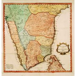
..Karte von der halb=Insil Indiens diesseits dem Ganges.
Fine map of India and northern part of Sri-Lanka. Text is in German. The map is decorated with small elephants, Lions, trees, etc.RARE. Engraved by Christian Liebe, engra...
Date: Halle c. 1750
Selling price: ????
Please login to see price!
Sold
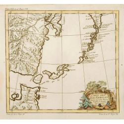
Carte des Isles Kouriles.
A good impression of a detailed, finely engraved map of the north of Honshu. Derived from Russian maps resulting from the expeditions of Bering, Cherikov and others, one ...
Date: Paris 1750
Selling price: ????
Please login to see price!
Sold
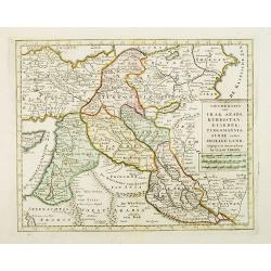
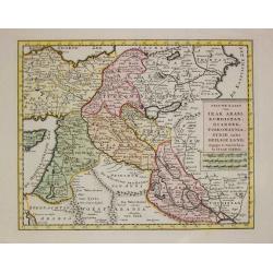
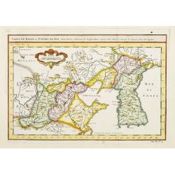
Nieuwe kaart van Irak Arabi, Kurdistan, Diarbek. . .
Detailed map including the northern part of the Arabian peninsular, Palestine, Iraq, Iran and the eastern part of Cyprus.
Date: Amsterdam, 1750
Selling price: ????
Please login to see price!
Sold in 2017
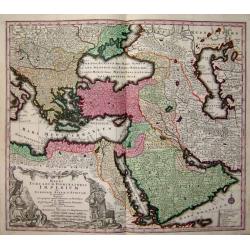
Magni Turcarum dominatoris Imperium
A fine decorative map of the Turkish Empire by Seutter.
Date: Germany, c. 1750
Selling price: ????
Please login to see price!
Sold
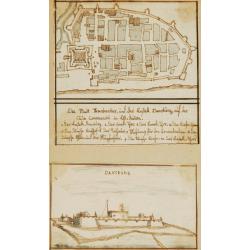
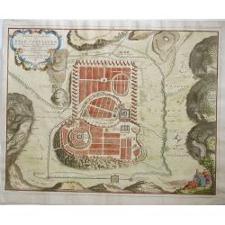
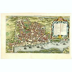
Die Stadt Frankenbar and fort Dansburg.
Charming 18th water color on paper depicting the fortification and town plan of the Danish East India Company Trading post Dansburg on the Indian west coast.In top the ci...
Date: c.1750
Selling price: ????
Please login to see price!
Sold
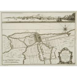
Carte des environs de Batavia avec la vuë de cette ville.
Map of Jakarta and surroundings with a separate view on top.From Prévost's important Collection of Voyages.
Date: Paris, 1750
Selling price: ????
Please login to see price!
Sold
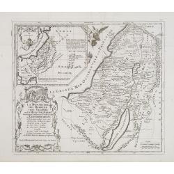
La monarchie des hébreux sous Salomon, ou le royaume d'Israël distingué en douze préfectures ou gouvernements / par le Sr. Moullart-Sanson. . .
Scarce map of Kingdom of Israel. Published by Pierre Moullart-Sanson, who was the grandson of Nicolas the elder.Very decorative title cartouche. On the upper left corner,...
Date: Paris, ca. 1750
Selling price: ????
Please login to see price!
Sold in 2015
Les Voiages de notre Seigneur Jesus Christ et des ..
Scarce map of the travels of Jesus, St Peter and St Paul. Published by Pierre Moullart-Sanson, who was the grandson of Nicolas the elder. Engraved by De la Haye.Very deco...
Date: Paris, ca. 1750
Selling price: ????
Please login to see price!
Sold in 2019
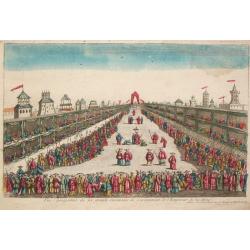
Vue perspective de la grande Ceremonie du couronnement de l'Empereur de la Chine.
An optical view of the coronation ceremony of the Chinese emperor.
Date: Paris, c. 1750
Selling price: ????
Please login to see price!
Sold
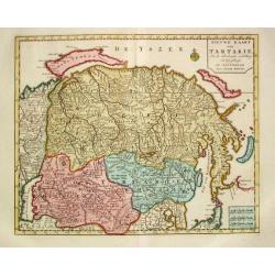
Nieuwe Kaart van Tartarie
Izaak Tirion (d. 1769) Amsterdam publisher. His ' Nieuwe en beknopte handatlas' saw 6 editions between before 1740 and after 1784. Also ' Tegenwoordige staat van alle vol...
Date: Amsterdam, c. 1750
Selling price: ????
Please login to see price!
Sold
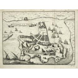
Ile d' Ormus ou de Jerun
A bird's-eye view of the island of Ormus in the Persian Gulf.
Date: Paris, c. 1750
Selling price: ????
Please login to see price!
Sold in 2020
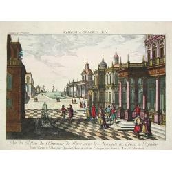
Vue du Pallais du l'Empereur de Perse avec la Mosquée, ou Eglise a Ispahan.
An optical print of the court of the Persian Emperor.
Date: Augsburg, c. 1750
Selling price: ????
Please login to see price!
Sold in 2018

Vue de la Cour du l'Empereur de Perse...
An optical print of the court of the Persian Emperor.
Date: Augsburg, c. 1750
Selling price: ????
Please login to see price!
Sold in 2018
Irak Arabi, Kurdistan, Diarbek, Turkomania, Syrie en het Heilige Land.
Izaak Tirion (d. 1769) Amsterdam publisher. His ' Nieuwe en beknopte handatlas' saw 6 editions between before 1740 and after 1784. Also ' Tegenwoordige staat van alle vol...
Date: Amsterdam, c. 1750
Selling price: ????
Please login to see price!
Sold
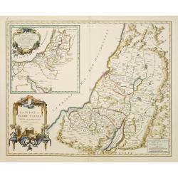
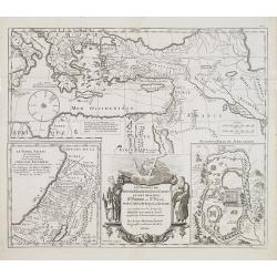
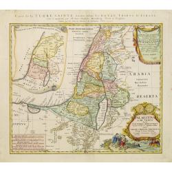
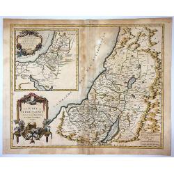
La Judée ou Terre Sainte divisée en ses douze tribes.
A finely engraved and uncommon map depicting the division of the Holy Land into twelve tribes. In upper left hand corner inset map of land of Canaan. Decorative title car...
Date: Paris, 1750
Selling price: ????
Please login to see price!
Sold
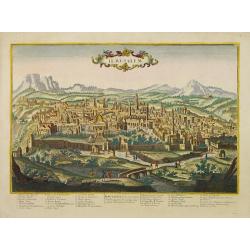
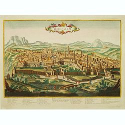
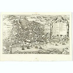
Ierusalem.
A rare and beautifully engraved and richly detailed panoramic view of Jerusalem. With in lower part numbered key (1-36) with description of most important buildings of Je...
Date: France, ca. 1750
Selling price: ????
Please login to see price!
Sold in 2008
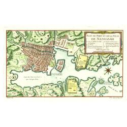
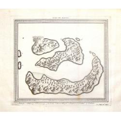
Plan du Port et de la Ville de Nangasaki.
This plan originates from Charlevoix's work Histoire et description Générele du Japon . His first in 1715 published work was the Histoire de l'etablissement du christia...
Date: Paris 1750
Selling price: ????
Please login to see price!
Sold in 2021
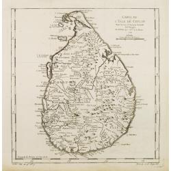
Carte de L'Isle de Ceylan..
A good engraved map of Ceylon. From l'Histoire générale des voyages .
Date: Paris 1750
Selling price: ????
Please login to see price!
Sold
Palaestina in XII. Tribus divisa. . .
Uncommon map of the Holy Land, colored according to the lands of the 12 tribes.Including northern part of Egypt. Prepared by Johannes Christoph Harenberg. With two very l...
Date: Nuremberg, 1750
Selling price: ????
Please login to see price!
Sold in 2023
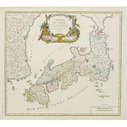
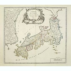
L' Empire Du Japon, divise en sept principales ..
Large map of Japan with a distinctively French style title cartouche containing two small landscapes.The map draws heavily on the previous work of Bellin, but includes a ...
Date: Paris 1750
Selling price: ????
Please login to see price!
Sold
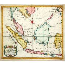
Carte des Isles de Java, Sumatra Borneo & Les Détroits de la Sonde Malaca et Banca Golphe de Siam.
Bellin's map of the Indonesian archipelago, also depicting Malaysia. Jacques Nicolas Bellin (1702-720) was the most important French hydrographer of the 18th century. He ...
Date: Paris, c. 1750
Selling price: ????
Please login to see price!
Sold in 2019
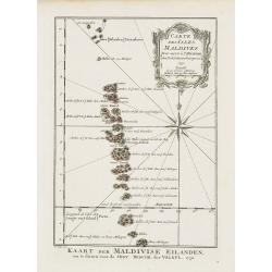
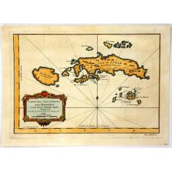
Carte des Isles Maldives.
A very nice map of the Maldives Islands from Atlas Portatif pour servir a l'intelligence de l'Histoire Philosophique et Politique des etablissements et du commerce des Eu...
Date: Amsterdam, 1750
Selling price: ????
Please login to see price!
Sold in 2018
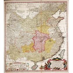
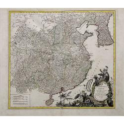
Regni Sinae vel Sinae Propriae Mappa et Descriptio Geographica.
China with the islands of Formosa and Hainan. Copper engraved map in contemporary color after du Halde and d'Anville by John Matth. Hase, published by the heirs of J.-B. ...
Date: Nuremberg, c. 1750
Selling price: ????
Please login to see price!
Sold in 2013
Afbeeldinge der stad Jerusalem..
Great bird's eye plan of the holy city.
Date: Gorinchem, 1750
Selling price: ????
Please login to see price!
Sold in 2008
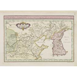
Carte du Katay ou Empire de Kin. . .
The map is of interest for the use of Mer de Corée, for the sea between Korea and Japan .Fine map of Korea and China's Yellow Sea. Complete title in top: Carte du Katay ...
Date: Paris, 1750
Selling price: ????
Please login to see price!
Sold in 2016
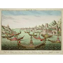
Vue de Siam avec diverses Sortes des Ballons, ou Vaisseaux Chinoise a Rame.
Optical print with view of Thailand.A so-called optical print. In the eighteenth and nineteenth centuries there were many popular speciality establishments in Paris, Augs...
Date: Augsburg, 1750
Selling price: ????
Please login to see price!
Sold in 2008
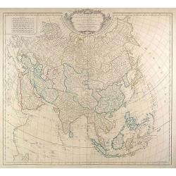
Carte de L'Asie dressée sur les Relations les plus . . .
Large map of Asia from Robert de Vaugondy\'s Atlas Universel. We see major political divisions and the state of European knowledge of the continent in the mid-18th centu...
Date: Paris, 1750
Selling price: ????
Please login to see price!
Sold in 2009
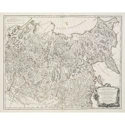
Partie Orientale de l'Empire de Russie en Asie . . . la Tartarie Chinoise . . .
Map of the Asian part of the Russian Empire and the Tartary region, including Sakhalin and Kamchatka..Tartary was a name used by Europeans from the Middle Ages until the ...
Date: Paris, 1750
Selling price: ????
Please login to see price!
Sold in 2013
Afbeelding van 'T Joodsche Land..
This attractive map from a large Dutch Bible shows the land of Israel with all the places, rivers, mountains, and seas mentioned in the Holy Scriptures. It covers all of ...
Date: Gorinchem, 1750
Selling price: ????
Please login to see price!
Sold in 2009
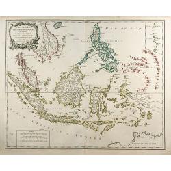
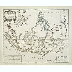
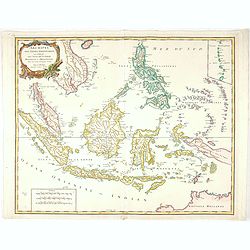
Archipel Des Indes Orientales, qui comprend Les Isles De La Sonde ... Philippines ...
An attractive and detailed view of the Indonesian islands in large format. Decorative title cartouche.
Date: Paris, 1750
Selling price: ????
Please login to see price!
Sold in 2009
Jerusalem comme elle est a present.
A very decorative and extremely rare of Jerusalem, including a numbered (1-36) key in lower part. Published by Jacques Chéreau, (1688 - 1776). Engraved by Aveline and f...
Date: Paris, ca.1750
Selling price: ????
Please login to see price!
Sold in 2013
La Judée ou Terre Sainte divisé en ses douze Tribus, ...
A finely engraved and uncommon map depicting the division of the Holy Land into twelve tribes. In upper left hand corner inset map of land of Canaan. Decorative title car...
Date: Paris, 1750
Selling price: ????
Please login to see price!
Sold in 2011
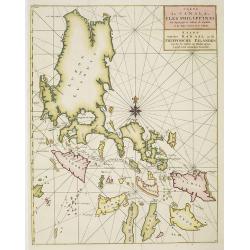
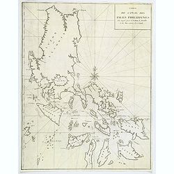
Carte du Canal des Iles Philippines. . . / Kaart van het kanaal in de Filippynsche eilanden waar door het galjoen van Manilla passeert te gelyk met de naastgelegen eilanden.
Splendid chart of the Philippines illustrating the track of the Manila galleon route. The coasts of the islands are fairly accurately charted but there are no details inl...
Date: Amsterdam, ca. 1750
Selling price: ????
Please login to see price!
Sold in 2015
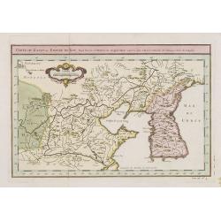
Carte du Katay ou Empire de Kin, Pour servir a l'histoire de Jenghiz Khan. raportée dans l'histoire generale des voyages. Tirée de l'Anglois.
Fine map of Korea and China's Yellow Sea. Complete title in top: Carte du Katay ou Empire de Kin, pour servir de l'Histoire de Jenghiz Khan. Raportée dans histoire Gén�...
Date: Paris, 1750
Selling price: ????
Please login to see price!
Sold in 2011
Carte du Katay ou Empire de Kin. . .
Fine map of Korea and China's Yellow Sea. Complete title in top: Carte du Katay ou Empire de Kin, pour servir de l'Histoire de Jenghiz Khan. Raportée dans histoire Gén�...
Date: Paris, 1750
Selling price: ????
Please login to see price!
Sold
Archipel Des Indes Orientales, qui comprend Les Isles De La Sonde.. Philippines..
An attractive and detailed view of the Indonesian islands in large format. Decorative title cartouche.
Date: Paris, 1750
Selling price: ????
Please login to see price!
Sold in 2011
L'Empire du Japon divisé en sept principales parties. . .
Large map of Japan with a distinctively French style title cartouche containing two small landscapes.The map draws heavily on the previous work of Bellin, but includes a ...
Date: Paris, 1750
Selling price: ????
Please login to see price!
Sold in 2011
![[SET OF 7 MAPS OF CHINA, ca. 1750]](/uploads/cache/91735-250x250.jpg)
[SET OF 7 MAPS OF CHINA, ca. 1750]
Interesting set of seven regional copper-engraved maps and plans of China by or after Bellin, dating to around 1750. List of the maps: 1: Carte des isles qui sont a l'en...
Date: Paris, 1750
Selling price: ????
Please login to see price!
Sold in 2011
Ierusalem.
A rare, beautifully engraved and richly detailed panoramic view of Jerusalem. Numbered key (1-36) on the lower part with description of most important buildings of Jerusa...
Date: France, c.1750
Selling price: ????
Please login to see price!
Sold in 2011
Archipel Des Indes Orientales, qui comprend Les Isles De La Sonde.. Philippines..
An attractive and detailed view of the Indonesian islands in large format and Malacca and Southern China to the Philippines, New Guinea and Northern Australia. Includes a...
Date: Paris, 1750
Selling price: ????
Please login to see price!
Sold in 2013
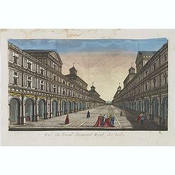
Vue du serail du grand Mogol, des Indes.
Optical print of a Mogul Palace in India. Published by Jacques Chereau, who was a well-known publisher of optical prints, established in rue St. Jacques in Paris. In the ...
Date: Paris, ca. 1750
Selling price: ????
Please login to see price!
Sold in 2019
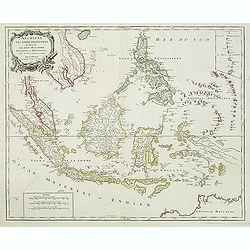
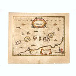
ISLES MOLUQUES.
Highly detailed map of the famous Spice Islands (Maluku Islands or the Moluccas). Includes also Sulawesi, Bali, Timor, part of Borneo, New-Guinea with unfinished coast li...
Date: Paris, c1750
Selling price: ????
Please login to see price!
Sold in 2013
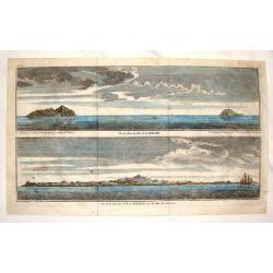
Vue de Deux des Iles des Larrons & Vue de la Cote du N.O. Saypan, une des Iles des Larons.
Views of several of the Mariana Islands in the Philippines Sea in the South Pacific. From George Anson's "Voyage Aurout du Monde". George Anson, 1st Baron Anson...
Date: Paris, 1750
Selling price: ????
Please login to see price!
Sold in 2015
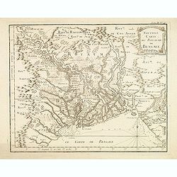
Nouvelle carte du Royaume de Bengale.
Detailed regional map of the Gulf of Bengal and the lower Ganges River.
Date: Paris, c.1750
Selling price: ????
Please login to see price!
Sold in 2015
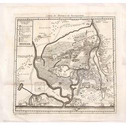
Carte du District de Tranquebar.
Decorative, detailed plan of Tharangambadi India, on the Coromandel Coast. It was founded by the Danish East India Company in 1620 and was sold to England in 1845. The ma...
Date: Paris, 1750
Selling price: ????
Please login to see price!
Sold in 2015
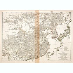
(Map of China, Korea and Japan)
A large detailed map of China, Korea and Japan prepared and published by Jean Baptiste Bourguignon d’Anville. This is the upper part of his two-sheet map of the Far Eas...
Date: Paris, c. 1750
Selling price: ????
Please login to see price!
Sold in 2014

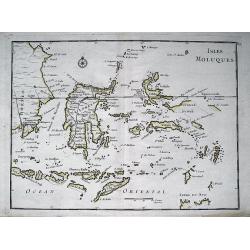
Carte des Isles Voisines des Moluques.
Map of the province of Moluccas, Indonesia including Ceram, Bouro, Amboine and Neyra. Published by Pierre de Hondt for Prevost's "L'HISTOIRE GENERALE DES VOYAGES&quo...
Date: Paris, ca.1750
Selling price: ????
Please login to see price!
Sold in 2016
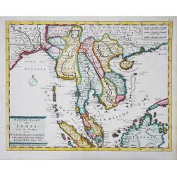
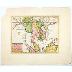
Nieuwe kaart van India over de Ganges, of van Malakka, Siam, Cambodia, Chiampa, Kochinchina, Laos, Pegu, Ava, enz.
Isaac Tirion's attractive map of Indochina, the Malaysian Peninsula and the northern parts of Sumatra and Borneo. The mythical Lac Chaamay is still shown in Acham. Isaak ...
Date: Amsterdam, c. 1750
Selling price: ????
Please login to see price!
Sold in 2016
Isles de Banda.
Striking map of the Indonesian Islands of Banda including Pulorin, Puloway, Gunnanapi, Labetak, Nera etc. It was engraved by Didot in Paris in 1750.
Date: Paris, 1750
Selling price: ????
Please login to see price!
Sold in 2014
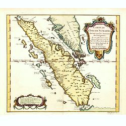
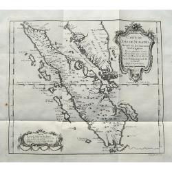
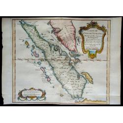
Carte de L'Isle de Sumatra Dressee sur les Journaux des Navigateurs . . .
Detailed map of Sumatra and Malacca, centered on Singapore and including the southern portion of the Malaysian peninsula. With "Detroit de Sincapour" and severa...
Date: Paris, ca. 1750
Selling price: ????
Please login to see price!
Sold in 2014
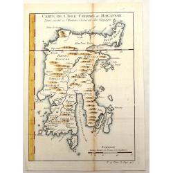
Carte de L'Isle Celebes ou Macassar.
Fine little copper engraved map of Celebes Island, Makassar (Buginese-Makassar language:– sometimes spelled Macassar, Mangkasara) – It is the provincial capital of So...
Date: Paris, 1750
Selling price: ????
Please login to see price!
Sold in 2015
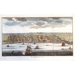
Samboupo.
Detailed view of Samboupo on the island of Celebes (Sulawesi) Indonesia. Over one dozen ships are sailing in the harbour and river. By Jacob van der Schley in 1750.
Date: Paris, 1750
Selling price: ????
Please login to see price!
Sold in 2019

Carte de la Baye de Chin-Chew ou Chang-Chew avec les Isles d'Emowi et de Quimowi
A copper engraved chart of the estuary of the Chiu-lung River at present-day Hsia-men, on the mainland coast, adjacent to Taiwan. Chart shows the location of a few villag...
Date: Paris, c1750
Selling price: ????
Please login to see price!
Sold in 2016
L'Empire de la Chine dressé d'après les cartes de l'Atlas Chinois...
A detailed, large map of China, Korea and Taiwan. The large and spectacular title cartouche is in the typical French style, with musicians, a dancer, and various details ...
Date: Paris, ca 1750
Selling price: ????
Please login to see price!
Sold in 2016
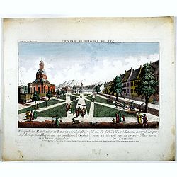
Prospect des Rathhauses in Batavia wie dasselbige auf dem grossen Platz nebst der um liegende Gegend (von fornen anzusehen).
A view of present-day Fatahillah Square in Jakarta. In the middle of the print the Raadhuis , headquarters of the VOC -nowadays the Jakarta museum-is clearly visible.
Date: Augsburg, 1750
Selling price: ????
Please login to see price!
Sold in 2016
Carte des Isles Voisines Des Moluques
An old antique cartographic map of the Molucas Isles in Indonesia, including Ceram - Bouro Amboine - Banda – Neyra, by Bellin from Abbe A.F. Prévost’s, “Histoire G...
Date: Paris, 1750
Selling price: ????
Please login to see price!
Sold in 2016
Carte de L'Isle de Sumatra...
A detailed map of Sumatra and parts of the Malay Peninsula with the Straits of Singapore. Many towns, islands, and rivers are named.Decorated with a large title cartouche...
Date: Paris, ca 1750
Selling price: ????
Please login to see price!
Sold in 2017
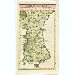
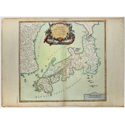
Carte de la Corée.
A rare map of Korea after d'Anville and engraved by Dheulan.
Date: Paris, ca. 1750
Selling price: ????
Please login to see price!
Sold in 2021
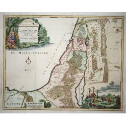
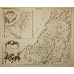
La Judee ou Terre Sainte Divisee en ses Douze Tribus.
Beautiful 1750 map of Israel, Palestine or the Holy Land by Robert de Vaugondy. It extends from Sidon to Gaza and Covers the region as it existed in Biblical times with d...
Date: Paris , 1750
Selling price: ????
Please login to see price!
Sold in 2017
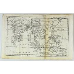
East Indies.
A fine map of the East Indies, bounded by China in the northeast, the Timors and New Guinea in the Southeast, India and the Maldives in the Southwest and Tibet and the Mo...
Date: London, ca. 1750
Selling price: ????
Please login to see price!
Sold in 2017
Plan de Goa.
A beautifully detailed and engraved town-plan of the Portuguese colony of Goa in India, with a number key (1-29) to the city's major monuments and sites, enclosed in a de...
Date: Paris, 1750
Selling price: ????
Please login to see price!
Sold in 2017
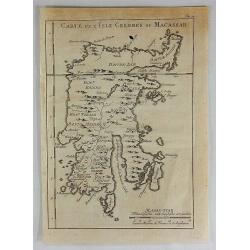
Carte de L'Isle Celebes ou Macassar.
A fine copper engraved map of Celebes Island. It is the provincial capital of South Sulawesi, Indonesia. It is the largest city on Sulawesi Island in terms of population ...
Date: Paris, 1750
Selling price: ????
Please login to see price!
Sold in 2018
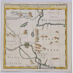
Carte du Pays ou Probablement a Ete le Paradis Terrestre, la Plaine de Scinhar et la Montagne sur Laquelle L'Arche...
A pleasant map detailing the region of present day Iraq and Armenia. It locates the Garden of Eden on the Euphrates River, by Bellin in Paris, published in 1750.Jacques N...
Date: Paris, 1750
Selling price: ????
Please login to see price!
Sold in 2018
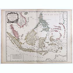
Archipel Des Indes Orientales, qui comprend Les Isles De La Sonde.. Philippines..
An attractive and detailed view of the Indonesian islands in large format and Malacca and Southern China to the Philippines, New Guinea and Northern Australia. Includes a...
Date: Paris, 1750
Selling price: ????
Please login to see price!
Sold in 2018
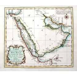
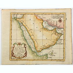
Carte de la coste d'Arabie Mer Rouge et Golfe de Perse. . .
A fine map of the Arabian Peninsula with the Persian Gulf, and the Red Sea. With many place names along the coasts. Decorated with the large title cartouche and some attr...
Date: Paris, ca. 1750
Selling price: ????
Please login to see price!
Sold in 2018
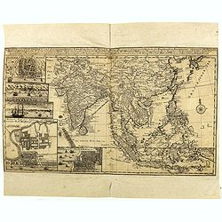
Charte von Ost-Indien und den Angraentzenden Laendern'... 'Geographi Mr. Herman Moll ... Durch M. Georg. Christian Bohnstedt Rector an der Dom-Schule zu Halberst. . .1737
Rare German map showing the area from India to Japan, and south to include the East Indies. The map is filled with information on political divisions, towns, and roads. T...
Date: Lepzig, ca. 1750
Selling price: ????
Please login to see price!
Sold in 2020
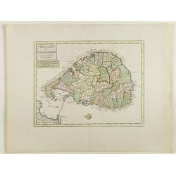
Nieuwe kaart van 't eiland Ceilon.
Fine map of present-day Sri Lanka with north oriented to the left. The legendary Adams Brug (Adam's Bridge or Rama's Bridge) is clearly shown linking Mannar island off Sr...
Date: Amsterdam, 1750
Selling price: ????
Please login to see price!
Sold in 2020
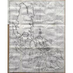
Carte du Canal des Philippines. . .
Large detailed chart of the Islands of the Philippines from the French edition of Anson's Voyages. Anson's voyages were one of the last great buccaneering voyages, and it...
Date: Paris, ca 1750
Selling price: ????
Please login to see price!
Sold in 2018
Plan de Goa.
A beautifully detailed and engraved town-plan of the Portuguese colony of Goa in India, with a number key (1-29) to the city's major monuments and sites, enclosed in a de...
Date: Paris, 1750
Selling price: ????
Please login to see price!
Sold in 2020
Carte de l'Isle de Sumatra....
Map of Sumatra, also showing the tip of the Malay Peninsula and the Straits of Singapore. An unusually detailed map of the area, showing many coastal features, shoals, ba...
Date: Paris, 1750
Selling price: ????
Please login to see price!
Sold in 2018
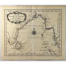
Carte du Golphe de Bengale.
A fine copper engraved map of the Gulf of Bengal including the island of Celon. It features a decorative title cartouche and a large fancy compass rose. Bellin prepared t...
Date: Paris, 1750
Selling price: ????
Please login to see price!
Sold in 2021
Carte du Canal des Iles Philippines par lequel Passe le Galion de Manille. . .
A detailed copper-engraved sea-chart, the first obtainable large format map, and one of the best maps of the Philippines from the 18th century.It provides excellent detai...
Date: Paris, 1750
Selling price: ????
Please login to see price!
Sold in 2019
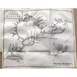
Plan de la Baye de Manille.
One of the earliest obtainable plans of Manila published in 1750. The detailed chart of the Manila Bay includes anchorages, soundings, rocks, and several places are named...
Date: Paris, 1750
Selling price: ????
Please login to see price!
Sold in 2019
L'EMPIRE DU JAPON
Large map of Japan with a distinctively French style title cartouche containing two small landscapes.The map draws heavily on the previous work of Bellin, but includes a ...
Date: Paris 1750
Selling price: ????
Please login to see price!
Sold in 2019
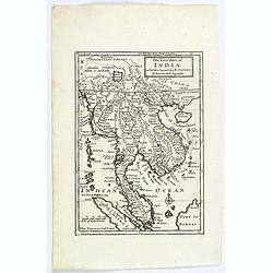
The East Part of India, or India beyond the R. Ganges.
Herman Moll's map of those Asian countries.
Date: London, ca 1750
Selling price: ????
Please login to see price!
Sold in 2020
Carte de la Coste d'Arabie, Mer Rouge, et Golfe de Perse. . .
A pleasant map of the Arabian Peninsula, the Red Sea and the Gulf region, published in Paris during the mid 18th century. Published in the "Histoire générale des V...
Date: Paris, ca 1750
Selling price: ????
Please login to see price!
Sold in 2021
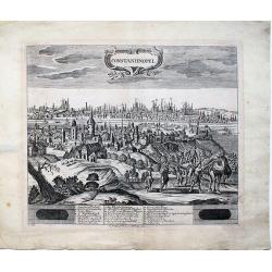
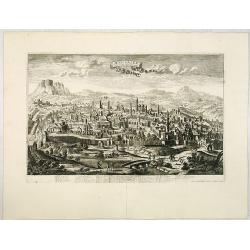
Constantinopel.
A very rare, extremely detailed view of IstanbuI that depicts the city from Galata with realistic scenes of every-day life. Both sides of the Golden Horn are delineated i...
Date: Dresden ca. 1750
Selling price: ????
Please login to see price!
Sold in 2023
Archipel Des Indes Orientales, qui comprend Les Isles De La Sonde.. Philippines..
An attractive and detailed view of the Indonesian islands in large format. Decorative title cartouche.
Date: Paris, 1750
Selling price: ????
Please login to see price!
Sold in 2021
Insularum Moluccarum ..
Exquisite map of the famous Spice Islands based on the islands described by Jan Huyghen van Linschoten. This map was the first large scale map of the region and depicts t...
Date: Amsterdam, 1750
Selling price: ????
Please login to see price!
Sold in 2020
Nieuwe kaart van India over de Ganges, Malakka, Siam..
A nice detailed map, incorporating information provided by French Jesuits, of Indochina, the Malayan peninsular and the northern parts of Sumatra and Borneo. The mythical...
Date: Amsterdam, 1750
Selling price: ????
Please login to see price!
Sold in 2020