Browse Listings in America > South America
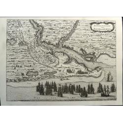
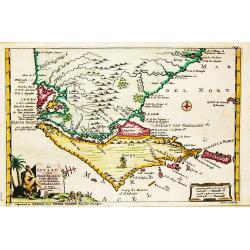
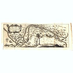
Afbeeldinghe van Pariba ende Forten.
This bird's-eye map shows the region of Paraiba and Portuguese fortifications at the mouth of the River Paraiba. A very early view of this region with highly detailed and...
Date: Amsterdam, 1690
Selling price: ????
Please login to see price!
Sold in 2021
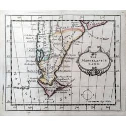
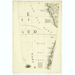
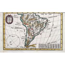
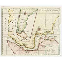
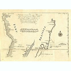
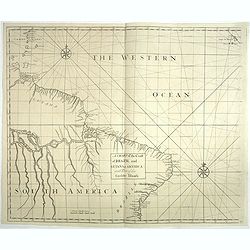
The Magellanick Land.
A rare miniature map of Patagonia from John Seller's 'A New Systeme of Geography'. With a compass and decorative title cartouche.
Date: London, 1690
Selling price: ????
Please login to see price!
Sold in 2020
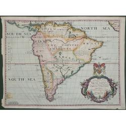
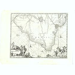
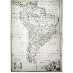
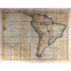
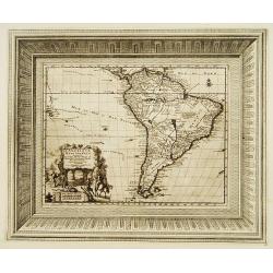
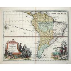
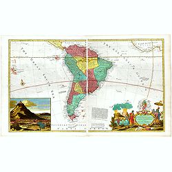
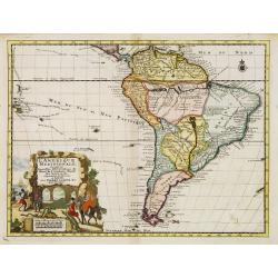
A New Map of South America Showing its General Divisions Chief Cities & Towns: Rivers, Mountains dedicated to his highness William Duke of Gloucester
Striking map of South America showing mainly large rivers and lakes but with notes about discovery, has A very large elaborate title cartouche and colored by regions. Thi...
Date: Oxford, 1690
Selling price: ????
Please login to see price!
Sold in 2011
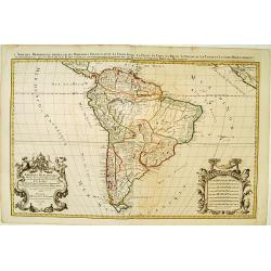
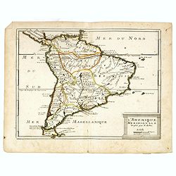
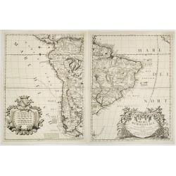
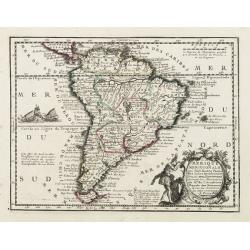
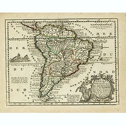
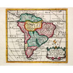
Amerique Meridionale..
From Jaillot's Atlas Nouveau. A very impressive large scale map: the large decorative title cartouche is balanced by an equally large cartouche around the scale bars, sur...
Date: Paris 1691
Selling price: ????
Please login to see price!
Sold
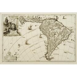
L'Amérique Méridionale.
An interesting small map of South America by Nicolas de Fer. From his rare "Petit et Nouveau Atlas". The first edition was published in 1697 and was republished...
Date: Paris, 1692
Selling price: ????
Please login to see price!
Sold in 2018
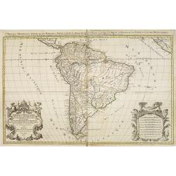
L'Amerique meridionale divisée en ses principales parties ou sont distingués les vns des autres les estats suivant qu'ils appartiennent présentement aux François, Castillans, Portugais, Hollandois, &c
Very good impression of Jaillot's large map of South America. With additional title in top. The map include lines of latitude and longitude, some topographical details, l...
Date: Amsterdam, c.1692
Selling price: ????
Please login to see price!
Sold
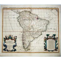
L'Amerique Meridionale Divisee en ses Principales Parties. . .
A handsome large-format map of South America by Jaillot, based upon the earlier maps of Nicholas Sanson. From: 'Atlas Royal', Amsterdam, 1694.Jaillot’s map is well-framed...
Date: Amsterdam, 1694
Selling price: ????
Please login to see price!
Sold in 2021
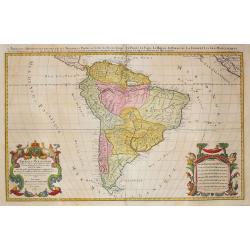
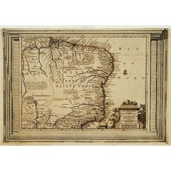
Amerique meridionale divisee en ses principales.
An attractive large-format map of the South American continent, embellished with two large cartouches. Newly engraved for the counterfeited edition of the 'Atlas Nouveau'...
Date: Amsterdam, 1696
Selling price: ????
Please login to see price!
Sold in 2022
America meridionale Auttore Il P.M. Coronelli M.C. Cosmografo della Serenissima Repub. Di Venetia..
Matching set of 2 attractive large folio maps depicting all of South America in the grand Coronelli style. Splendid large ornate cartouche with Coronelli's normal flouris...
Date: Venice 1696
Selling price: ????
Please login to see price!
Sold
(Globe gore) Della citta di Chiloe. . .
Globe segment published in 1696 as part of the atlas entitled "Libri dei Globi". The page contains part of the west coast of Chili and Peru. This atlas containe...
Date: Venice, 1696
Selling price: ????
Please login to see price!
Sold in 2012
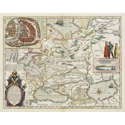
Terre Ferme et Nouv. Royaume de Grenade et Popaian.
Charming and uncommon map of today territory of Colombia. Decorated with a compass rose and title cartouche.
Date: Amsterdam, 1700
Selling price: ????
Please login to see price!
Sold in 2015
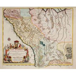
Peru ou Perou.
Charming map of Peru. Including some of the territory of today Equador on the north and extending southwards as far as the Atacama desert in Chile. Decorated with a large...
Date: Amsterdam 1700
Selling price: ????
Please login to see price!
Sold
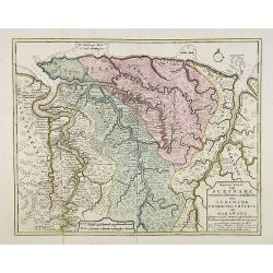
Nieuwe kaart van Suriname vertonende de stromen en land-streken van Suriname, Comowini, Cottica en Marawini, gelegen in Zuid America op de kusten van Caribana. . .
Decorative full color example of Ottens map of Suriname. Detailed map of the northeast part of Suriname between Paramaribo, with fort Zeelandia, and Mana. Along the Surin...
Date: Amsterdam, ca. 1700
Selling price: ????
Please login to see price!
Sold
Terre Ferme, Nouveau Royaume de Grenade ?
Fine map of Colombia, Venezuela and the islands of Curaçua, Aruba, Bonaire, etc ... Prepared by N. Sanson. Engraved by A. de Winter.
Date: Amsterdam, 1700
Selling price: ????
Please login to see price!
Sold in 2009
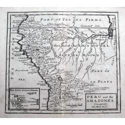
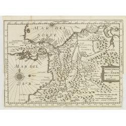
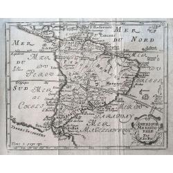
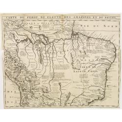
Peru and the Amazones Country.
Detailed copper engraved map showing parts of todays Peru, Ecuador, Bolivia, Brazil, Columbia, Chile and Argentina. From Quito until the mouth of the Amazonas. Includes a...
Date: London, ca. 1701
Selling price: ????
Please login to see price!
Sold in 2018
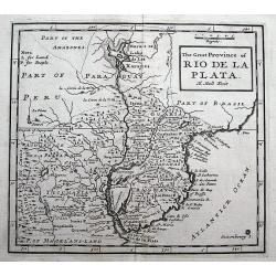
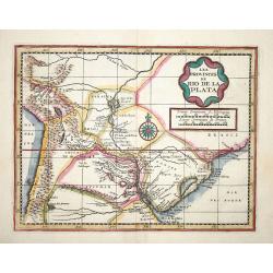
The Great Province of Rio de la Plata.
A detailed copper engraved map of parts of Brazil, Paraguay and Uruguay until Buenos Aires. Includes a curious Lake of Xarayes and the fictional Saxemberg Island.
Date: London, ca 1701
Selling price: ????
Please login to see price!
Sold in 2018
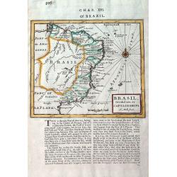
Brasil, divided into its Captainships.
Important map of Brazil when it was a Portuguese colony. It depicts the various captainships including Para, Maragnan, Siara, Rio Grande, Paraiba, Tamaraca, Pernambuco, S...
Date: London, 1701
Selling price: ????
Please login to see price!
Sold in 2019
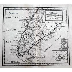
Chili Magellans-Land, and Terra del Fuego &c.
A detailed copper engraved map south of Paraguay with Chile, Argentina, Tierra del Fuego, Le Maire Strait, and a small tip of the Falkland Islands. Includes a curious 'Da...
Date: London, ca 1701
Selling price: ????
Please login to see price!
Sold in 2018
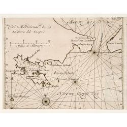
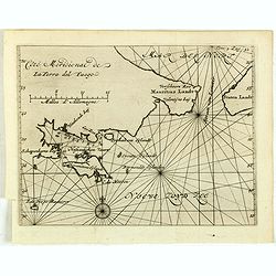
Mauritius.
Uncommom map of the southern most tip of Tiera del Fuego. From "Recueil des voiages qui ont servi a l'etablissement et aux progres de la Compagnie des Indes Oriental...
Date: Amsterdam, 1702
Selling price: ????
Please login to see price!
Sold
America australis dei parae Multas Sacras Aedes..
A map from the series of maps by the Jesuit mathematician. A general map of south America, produced by Scherer to show the spread of Catholicism in the continent. This de...
Date: Munich c.1702
Selling price: ????
Please login to see price!
Sold
America Ausralis.
A charming and boldly engraved map of South America. This is the bottom part of a map of the Americas by Scherer. With major lakes, rivers and mountains shown, as well as...
Date: Munich, 1702
Selling price: ????
Please login to see price!
Sold in 2017
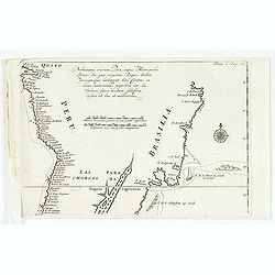
Pelineatis anarium Peru cujus Metropolis Lima : In qua vicarus Regis, Archie piscopusque . . . .
Uncommon map of the central part of South America with Peru, Brasil. Only coastal names.From a travel book describing the early Dutch voyages by René Augustin Constantin ...
Date: Amsterdam, E. Rogers, 1702
Selling price: ????
Please login to see price!
Sold in 2016
Carte de la Terre Ferme du Perou, du Bresil.
A scarce state of the very detailed map includes Brazil, Peru and the Amazonian part. Very decorative title cartouche on the upper right corner. Very decorative title car...
Date: Paris, 1703
Selling price: ????
Please login to see price!
Sold in 2025
Fretum Magellanicum in quod Olivier a Noord Generalis navium. . .
Map of the southern tip of South America including parts of Chile, Argentina, and Tierra del Fuego. Cartographic elements include scales of German and Spanish miles, comp...
Date: Amsterdam, E. Roger, 1703
Selling price: ????
Please login to see price!
Sold in 2012
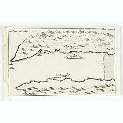
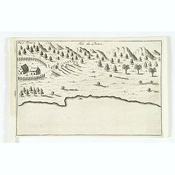
Porto il Desire.
Simplified bird's-eye view of Port Desire or Puerto Deseado in present-day Argentina.From volume two of the French reissue of the account of early Dutch voyages. The Fren...
Date: Amsterdam, E. Rogers, 1703
Selling price: ????
Please login to see price!
Sold in 2013
Rio Janeiro.
Scarce map of the Guanabara Bay with Rio de Janeiro, from Constantin Renneville's "Recueil des voyages qui ont servi a l'etablissement et aux progres de la Compagnie...
Date: Amsterdam, 1703
Selling price: ????
Please login to see price!
Sold in 2015
Brasilia.
A very fine and decorative map of Brazil. From the book "A Collection of Voyages and Travels" by Churchill, the map came from the section containing a descripti...
Date: London, Printed for A. and J. Churchill, 1703
Selling price: ????
Please login to see price!
Sold in 2017
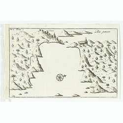
Rio Janeiro.
Simplified bird's-eye view of São Sebastião do Rio de Janeiro and Guanabara Bay, Brazil. Includes compass rose, church, and settlement.From volume two of the French reiss...
Date: Amsterdam, E. Roger, 1703
Selling price: ????
Please login to see price!
Sold in 2012
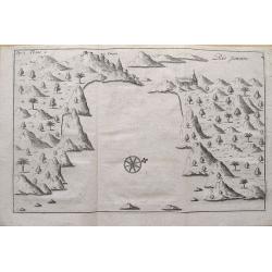
Isle du Prince.
Simplified bird's-eye view of "Isle du Prince" in present-day Argentina.From volume two of the French reissue of the account of early Dutch voyages. The French ...
Date: Amsterdam, E. Roger, 1703
Selling price: ????
Please login to see price!
Sold in 2013

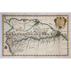
Nieuwe gelyk Graadige Paskaart van de Kust van Guiana in West-Indien.
Detailed chart of Guiana in South America. Two scales are given in both maps: Dutch, French and English nautical miles.The inset chart provide detailed view of the Camopi...
Date: Amsterdam, 1684 - 1704
Selling price: ????
Please login to see price!
Sold in 2026
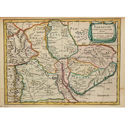
Paraguay.
Nicolas Sanson (1600-67), ' father of the French cartography' and founder of the Sanson firm. Atlas ' Cartes générales de toutes les parties du Monde', 1658-70 and a pock...
Date: Amsterdam, F. Halma, 1705
Selling price: ????
Please login to see price!
Sold
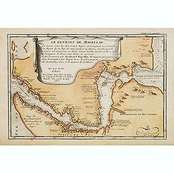
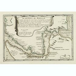
Le Detroit De Magellan Se trouve . . . Il fut decouvert par Ferdinand Magellan. . .
Somewhat uncommon map of the Straits of Magellan, showing soundings, place names and other details in the passage through the Strait. Engraved by the master engraver Inse...
Date: Paris, 1705
Selling price: ????
Please login to see price!
Sold in 2012
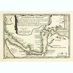
Le Detroit De Magellan . . . Se trouve . . . Il fut decouvert par Ferdinand . . .
Somewhat uncommon map of the Straits of Magellan, showing soundings, place names and other details in the passage through the Strait. Engraved by the master engraver Inse...
Date: Paris, 1705
Selling price: ????
Please login to see price!
Sold in 2017
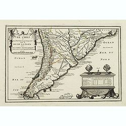
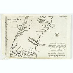
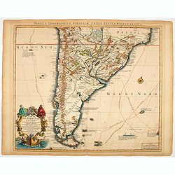
Le Chili et Les Provinces qui Composent Celle de Rio De La Plata avec Les Terres Magellanique. . .
Somewhat uncommon map of the southern part of South America, showing excellent detail along the River Plate and the Pacific Coast to the Andes mountains. Two globes and a...
Date: Paris, 1705
Selling price: ????
Please login to see price!
Sold in 2011
Le Detroit De Magellan . . . Se trouve . . . Il fut decouvert par Ferdinand . . .
Somewhat uncommon map of the Straits of Magellan, showing soundings, place names and other details in the passage through the Strait. Engraved by the master engraver Inse...
Date: Paris, 1705
Selling price: ????
Please login to see price!
Sold in 2011
![[Lot of 10 (2x maps / 8x views of Guyana)] d' Engleze Volksplanting in' t Amerikaans Gewest Gujana en Rio de Las Amazones. Door de Scheeps-Togt van Charles Leig Begonnen.](/uploads/cache/IMG_2322-250x250.jpg)
[Lot of 10 (2x maps / 8x views of Guyana)] d' Engleze Volksplanting in' t Amerikaans Gewest Gujana en Rio de Las Amazones. Door de Scheeps-Togt van Charles Leig Begonnen.
[Lot of 10 (2x maps / 8x views of Guyana]- d'Engelze Volkplanting in't Amerikaans gewest Gujana en Rio de las Amazones. circa 1700 - Land-Kaart van het Eiland en de Volk...
Date: Leiden, 1706-1707
Selling price: ????
Please login to see price!
Sold in 2023
d' Engleze Volksplanting in' t Amerikaans Gewest Gujana en Rio de Las Amazones. Door de Scheeps-Togt van Charles Leig Begonnen.
Pieter van der Aa was a prolific publisher. He published a.o. ' Naaukeurige versameling der gedenkwaardigste zee- en land-reysen', a series of accounts of voyages (1706-0...
Date: Leiden, 1707
Selling price: ????
Please login to see price!
Sold
Brasilaanze Scheepvaard door Johan Lerius Gedaan uit Vrankryk in' t Jaar 1556.
Pieter van der Aa was a prolific publisher. He published a.o. ' Naaukeurige versameling der gedenkwaardigste zee- en land-reysen', a series of accounts of voyages (1706-0...
Date: Leiden, 1707
Selling price: ????
Please login to see price!
Sold
De Straat van Magellaen Sedert deszelfgs eerste ondekker, F. Magellaen Ao 1520 meermaal bevaren.
Pieter van der Aa was a prolific publisher. He published a.o. ' Naaukeurige versameling der gedenkwaardigste zee- en land-reysen', a series of accounts of voyages (1706-0...
Date: Leiden, 1707
Selling price: ????
Please login to see price!
Sold in 2008
SOUTH AMERICA. Corrected from the Observations comunicated to the Royal Societys of London & Paris.
A lovely extra large map of South America, dedicated by Senex to the famous Astronomer and Mnathematician Edmund Halley LLD Savilian Professor of Geometery in Oxford and ...
Date: London, 1710
Selling price: ????
Please login to see price!
Sold in 2022
Amerique meridionale.
A small map of South America with an interestingly shaped of coast line. It shows a few dates and fictional islands. A large "Terres Inconnues" is shown in the ...
Date: Paris, ca 1710
Selling price: ????
Please login to see price!
Sold in 2019
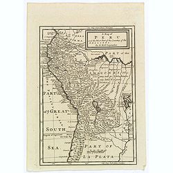
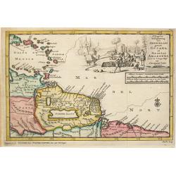
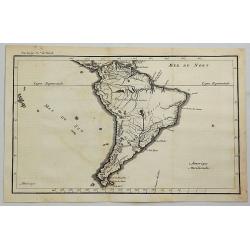
A Map of Peru and the West Part of the Country of the Amazones.
A map showing a good proportion of the west coast of South America, covering Peru, Chile, Western Brazil and Quito (Equador). Many coastal settlements and towns are engra...
Date: London, 1711
Selling price: ????
Please login to see price!
Sold in 2019
Nouvelle Carte de Geographie de la Partie Meridionale de l'Amerique Suivant les Plus Nouvelles Observations
A striking large map of South America, with information about various discoveries, expeditions, and colonies. In the Pacific, the routes of Magellan, Schouten & Le Ma...
Date: Paris, 1713
Selling price: ????
Please login to see price!
Sold in 2016
Les Provinces de Rio de la Plata.
Extremely rare map of the region including the Paraguay River basin and the Peru-Chilean coast with Lake Titicaca. The Rio de la Plata is boldly shown with many large isl...
Date: Leiden 1714
Selling price: ????
Please login to see price!
Sold
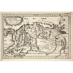
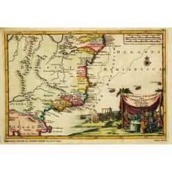
Cours du Fleuve Maragon Autrement du de Amazones. . .
This was the first close to correct chart of the Maranon territory. The map shows all of northern South America, and locates Lima and Cusco. With a decorative title carto...
Date: London, 1717
Selling price: ????
Please login to see price!
Sold in 2018
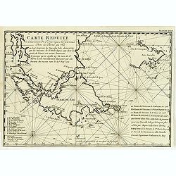
Carte réduite de l'extrémité de l'Amérique méridionale dans la partie du Sud . . .
Map of the southern extremities prepared by the French military engineer, mathematician, spy, and explorer Amédée-François Frezier (1682-1773).He is best remembered for b...
Date: Amsterdam, Pierre Humbert, 1717
Selling price: ????
Please login to see price!
Sold in 2012
L' Amerique Meridionale qui fait l' autre Partie des Indes Occidentales, Dressée tres Exactement Suivant les Observations..
Charming small map of the South American continent with good detail. Decorated with a title cartouche with two natives in the Atlantic and a sea battle being waged in the...
Date: Paris 1719
Selling price: ????
Please login to see price!
Sold
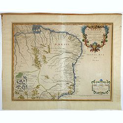
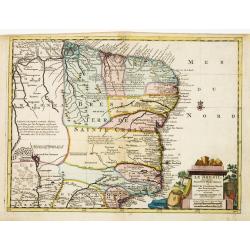
Le Bresil, dont les côtes sont divisées en capitaineries Dressé sur les dernières rélation. . .
Uncommon issue of this fine map of Brazil prepared by Nicolas de Fer, issued by Guillaume Danet.Originally published in atlas Atlas Curieux by N. de Fer in 1700-05, at hi...
Date: Paris, 1719
Selling price: ????
Please login to see price!
Sold in 2017
LE PEROU Dans l'Amérique Méridionale ?
Map of Peru including parts of present-day Ecuador, Bolivia, and Brazil. Cartographic elements include location of native American settlements, rivers, lakes, and wetland...
Date: Paris, 1719
Selling price: ????
Please login to see price!
Sold in 2009
L' Amerique Meridionale qui fait l' autre Partie des Indes Occidentales, Dressée tres Exactement Suivant les Observations..
Charming small map of the South American continent with good detail. Decorated with a title cartouche with two natives in the Atlantic and a sea battle being waged in the...
Date: Paris, 1719
Selling price: ????
Please login to see price!
Sold
L'Amérique Méridionale..
Fine and uncommon map of south America. Very decorative title cartouche on the lower left corner. The map is printed within a large, elaborately engraved mock-frame borde...
Date: Leiden 1720
Selling price: ????
Please login to see price!
Sold
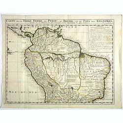
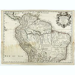
Carte de la Terre Ferme, du Perou, du Bresil, et du Pays des Amazones. . .
Handsome map of the northern part of South America based on the cartography of Guillaume Delisle.It is filled with place names and notations speculating about the Indian ...
Date: Amsterdam, 1720
Selling price: ????
Please login to see price!
Sold in 2017
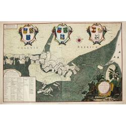
Platte Grond van Rio de Berbice.
Jan Daniel Knapp?s large-scale map of the Dutch plantations along the river Berbice in present day Guyana. The map shows the division of property and plantations and the ...
Date: Amsterdam, 1720
Selling price: ????
Please login to see price!
Sold
Carte du Paraguay, du Chili, du Detroit de Magellan &c.
A finely engraved, detailed map of the southern half of South America. Prepared by de l'Isle.
Date: Amsterdam, 1720
Selling price: ????
Please login to see price!
Sold in 2014
Amerique Meridionale.
A nice small map of South America.
Date: Amsterdam, 1721
Selling price: ????
Please login to see price!
Sold in 2008
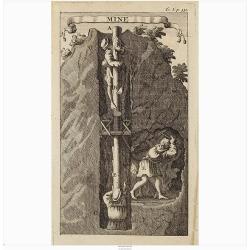
Mine.
Interesting print illustrating the entrance of a mine and part of a tunnel. It was mend to describe the hard labour to which the native Peruvian were forced.From "Vo...
Date: Amsterdam, 1722
Selling price: ????
Please login to see price!
Sold in 2020
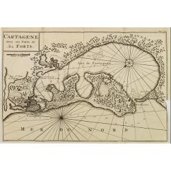
CARTAGENE Avec ses Ports et ses FORTS.
Decorative map of Cartagena, fortified colonial harbour in Colombia.
Date: Amsterdam 1722
Selling price: ????
Please login to see price!
Sold
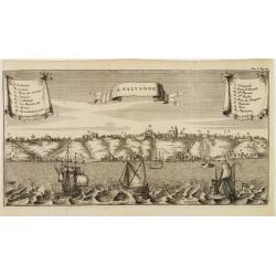
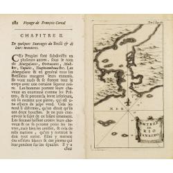
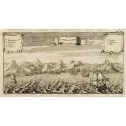
S. SALVADOR.
Charming view of Salvador de Bahia, in Brazil, seen from the ocean. With ribbon style title cartouche and 2 cartouches containing a key list. Decorated with 4 European ve...
Date: Amsterdam 1722
Selling price: ????
Please login to see price!
Sold
Entrée de Rio Janeiro.
Fine view of the entrance of Baía de Guanabara, in Rio de Janeiro.From Voyages de François Coreal aux Indes Occidentales, Contenant ce qu'il y a vû de plus remarquable pe...
Date: Amsterdam 1722
Selling price: ????
Please login to see price!
Sold
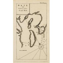
BAIE de Tous Les SAINS.
Fine view of Baía de Todos os Santos, in Bahia. With the town of Salvador outlined at the entrance of the bay.From Voyages de François Coreal aux Indes Occidentales, Cont...
Date: Amsterdam 1722
Selling price: ????
Please login to see price!
Sold
S. SEBASTIEN.
Charming view of São Sebastião de Rio de Janeiro, taken from the ocean. With ribbon style title cartouche and 2 cartouches containing a lettered key list (A-G). Decorated...
Date: Amsterdam 1722
Selling price: ????
Please login to see price!
Sold
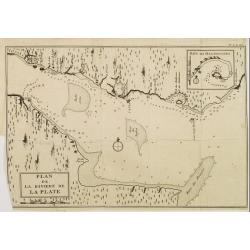
PLAN de la Riviere de la PLATE.
Appealing map focusing on the River de la Plata. With inset plan of "Baye des Maldonades", in Uruguay.From Voyages de François Coreal aux Indes Occidentales, Co...
Date: Amsterdam 1722
Selling price: ????
Please login to see price!
Sold
Carte du Dêtroit de Magellan.
Detailed map of Strait Magellan. With a key lower right stating the different smaller islands in the strait.Relief shown pictorially. Decorated with 2 large compass roses...
Date: Amsterdam 1722
Selling price: ????
Please login to see price!
Sold
Carte du Perou, du Fleuve des Amazones et du Bresil.
Appealing map focusing on the Amazon Basin, therefore including large part of the Brazilian Peruvian and Bolivian territories. Relief shown pictorially.From "Voyages...
Date: Amsterdam, 1722
Selling price: ????
Please login to see price!
Sold in 2010
AMERICA MERIDIONALIS.
Very attractive map of the continent of South America with typical 18th century cartography, much of it fanciful. The large pictorial title cartouche features the peoples...
Date: Nuremberg, 1724
Selling price: ????
Please login to see price!
Sold in 2012
...this map of South America...
Map of South America including part of Central America. Cartographic elements include lines of latitude and longitude, compass rose, indication of wind directions, locati...
Date: London 1725
Selling price: ????
Please login to see price!
Sold in 2021
Typus freti Magellanici quod . . .
Striking dark impression of De Renneville's edition of the Van Spilbergen map of the Straits of Magellan. The map includes a remarkable topographical treatment of the Str...
Date: Amsterdam, F. Bernard, 1725
Selling price: ????
Please login to see price!
Sold in 2017
Pelineatis anarium Peru cujus Metropolis Lima : In qua vicarus Regis, Archie piscopusque . . . . ( Tome 2 Page 48)
Uncommon map of the central part of South America with Peru, Brasil. Only coastal names.From the French reissue of the account of early Dutch voyages first published in 1...
Date: Amsterdam, F. Bernard, 1725
Selling price: ????
Please login to see price!
Sold in 2017
Côté méridional de la Terre Del Fuego.
Uncommon map of the southern most tip of Tiera del Fuego. From the French reissue of the account of early Dutch voyages first published in 1608 by Commelin. The French tr...
Date: Amsterdam, F. Bernard, 1725
Selling price: ????
Please login to see price!
Sold in 2017
Le Bresil, suivant les nouvelles observations. . .
Striking copper engraved map surrounded in a large picture-frame style border and title cartouche depicting mining. Great coastal detail with numerous notations concernin...
Date: Leyden, 1728
Selling price: ????
Please login to see price!
Sold in 2023
A chart of the coast of Brazil and Guiana in America with part of the Caribbe Islands.
This fine English chart of Brazil, Suriname and a few Caribbean Islands has two large compass roses in the Atlantic Ocean. From "Atlas Maritimus & Commercialis, ...
Date: London, 1728
Selling price: ????
Please login to see price!
Sold in 2017
L'Amerique Meridionale. Suivant les nouvelles observations?
Detailed map of South America. Decorative cartouche lower left.Although not renowned for the originality of his work, Pieter van der Aa is highly thought of for the desig...
Date: Amsterdam 1728
Selling price: ????
Please login to see price!
Sold
Le Bresil. Suivant les nouvelles observations?
Detailed map of Brazil. Decorative cartouche lower right.Although not renowned for the originality of his work, Pieter van der Aa is highly thought of for the design and ...
Date: Amsterdam 1728
Selling price: ????
Please login to see price!
Sold
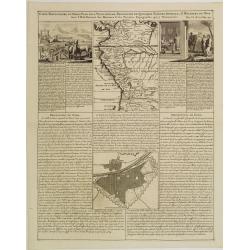
Carte Particuliere du Perou, Plan de la Ville de Lima, Description de Quelques Plantes, Animaux, &..
An interesting folio sheet containing two maps and two engravings with panels of French text. The top map covers the Northwest coast of South America from Panama to north...
Date: Amsterdam 1728
Selling price: ????
Please login to see price!
Sold
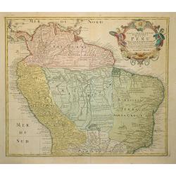
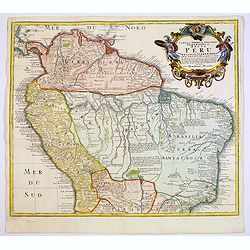
Tabula Americae Specialis Geographica Regni Peru . . .
A good and clean copy of Homann's map of the northern part of South America. Imposing title cartouche.
Date: Nuremberg 1728
Selling price: ????
Please login to see price!
Sold in 2011
Amerique Meridionale.
A striking map of South America from the “METHODE POUR ETUDIER L’HISTOIRE” by L’Abbe Lenglet du Fresnoy, published in Paris in 1729. The map is quite rare, and is not now...
Date: Paris, 1729
Selling price: ????
Please login to see price!
Sold in 2020
Descripcion de la provincia de Chile.
Map of the Chile. Cartographic elements include topographical details and location of some rivers and settlements. The map was copied from the manuscript map of Juan Lópe...
Date: Madrid, 1730
Selling price: ????
Please login to see price!
Sold in 2012
![[JESUIT PARAGUAY], - PARAQUARIA in qua R.R. P.P Soc. Jesu suas Missiones promovere, 1733](/uploads/cache/98366-250x250.jpg)
[JESUIT PARAGUAY], - PARAQUARIA in qua R.R. P.P Soc. Jesu suas Missiones promovere, 1733
This map depicts the Jesuit missions in Paraguay and Uruguay with parts of Brazil, Bolivia, Argentina and Chile. The Parana and Paraguay Rivers are well defined, with the...
Date: Vienna, 1733
Selling price: ????
Please login to see price!
Sold in 2022
Tabula Americae Specialis Geographica Regni Peru, Brasiliae, Terra Firmae & Reg: Amazonum, Secundum relationes de Herrera. . .
A good and clean copy of the top half of Homann's map of the northern part of South America. The map is on the Valley of the Amazon and delineates the Amazon and its laby...
Date: Nuremberg, 1733
Selling price: ????
Please login to see price!
Sold in 2017
![Tabula Americae Specialis Geographica Regni Peru, Brasiliae, Terra Firmae & Reg: Amazonum, Secundum relationes de Herrera . . . [together with]](/uploads/cache/37397-250x250.jpg)
Tabula Americae Specialis Geographica Regni Peru, Brasiliae, Terra Firmae & Reg: Amazonum, Secundum relationes de Herrera . . . [together with]
A good and clean copy of Homann's map of the northern part of South America. The map is on the Valley of the Amazon and delineates the Amazon and its labyrinth of tributa...
Date: Nuremberg, 1733
Selling price: ????
Please login to see price!
Sold in 2016
