Browse Listings in America > South America > Colombia
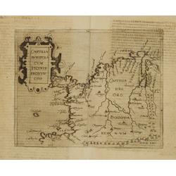
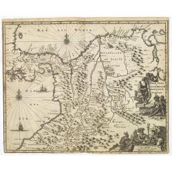
Castilia Aurifera cum vicinis Provinciis.
Very rare sixteenth century map of Colombia.Published in the German edition of José de Acosta's De Natura Nova Orbis, first published in Salamanca, 1588. Acosta was a Sp...
Date: Cologne 1598
Selling price: ????
Please login to see price!
Sold
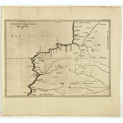
Descripcion Del Audiencia Del Quito. (Colombia & Ecuador)
Rare early map of now Ecuador and Quito. From Antonio de Herrera y Tordesillas Description des Indes Occidentales Qu'on appelle aujourdhuy Le Nouveau Monde. .. This map i...
Date: Amsterdam, Michel Colin, 1622
Selling price: ????
Please login to see price!
Sold in 2017
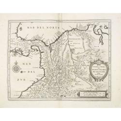
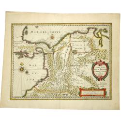
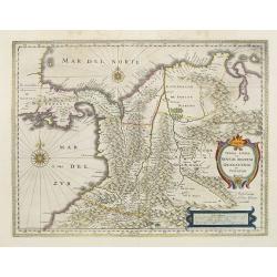
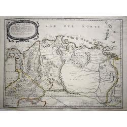
Terra Firma item Nuevo Reyno De Granada atque Popayan.
Important map showing the northern and northwestern area of South America, including Colombia, with extensive development of the interior areas. In the left part of the m...
Date: Leiden, Elzevier, 1625
Selling price: ????
Please login to see price!
Sold in 2013
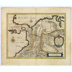
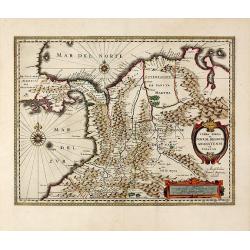
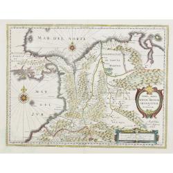
Terra Firma et Novum regnum Granatense et Propayan.
Good copy, with wide margins of this handsome map of the Isthmus of Panama and northwestern South America, including most of present day Columbia and part of Venezuela.Te...
Date: Amsterdam, ca. 1631
Selling price: ????
Please login to see price!
Sold in 2017
![[Vespucci lands on Colombian shores.]](/uploads/cache/40077-250x250.jpg)
[Vespucci lands on Colombian shores.]
Perhaps the first Europeans ever to reach Colombian shores where Alonso de Ojeda and his crew during their voyage in 1499-1500. Amerigo Vespucci was reputed to be among t...
Date: Frankfurt, M.Merian, 1633
Selling price: ????
Please login to see price!
Sold
TERRA FIRMA et NOVUM REGNUM GRANATENSE et POPAYAN.
A fine example of this handsome map of modern-day Panama and Colombia. Decorated with a cartouche, a distance memorandum and two rose compasses. Very fine and rare. Frenc...
Date: Amsterdam, 1635
Selling price: ????
Please login to see price!
Sold in 2019
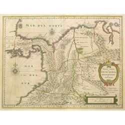
Terra Firma et Novum Regnum Granatense et Popayan.
Decorative, old colored copper engraved map of Colombia by J. Janssonius. Shows parts of Ecuador with Esmeraldas in the south-west, up to Venezuela in the East. With the ...
Date: Amsterdam, 1637
Selling price: ????
Please login to see price!
Sold in 2015
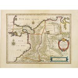
Terra Firma et Novum regnum Granatense et Propayan.
Fine copy, with wide margins of this handsome map of the Isthmus of Panama and northwestern South America including most of present day Columbia and part of Venezuela. Te...
Date: Amsterdam, 1638
Selling price: ????
Please login to see price!
Sold in 2010
Terra Firma et Novum regnum Granatense et Propayan.
Fine copy, with wide margins of this handsome map of the Isthmus of Panama and northwestern South America including most of present day Columbia and part of Venezuela. Te...
Date: Amsterdam, 1640
Selling price: ????
Please login to see price!
Sold
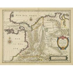
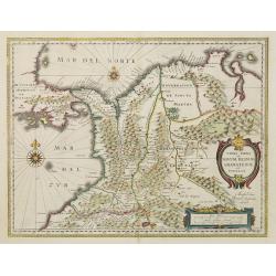
Terra Firma et Novum Regnum Granatense et Popayan
The northwest corner of South America including present day Panama and Columbia. Shows Panama City, Cartagena and Cali. Graphically depicts the rugged terrain of the uppe...
Date: Amsterdam, 1640
Selling price: ????
Please login to see price!
Sold in 2009
Terra Firma et Novum regnum Granatense et Propayan.
Fine copy, with wide margins of this handsome map of the Isthmus of Panama and northwestern South America including most of present day Columbia and part of Venezuela. Te...
Date: Amsterdam, 1645
Selling price: ????
Please login to see price!
Sold in 2008
Terra Firma et Novum regnum Granatense et Propayan.
Fine copy, with wide margins of this handsome map of the Isthmus of Panama and northwestern South America including most of present day Columbia and part of Venezuela. Te...
Date: Amsterdam, 1647
Selling price: ????
Please login to see price!
Sold in 2008
Terra Firma et Novum regnum Granatense et Propayan.
Fine copy, with wide margins of this handsome map of the Isthmus of Panama and northwestern South America including most of present day Columbia and part of Venezuela. Te...
Date: Amsterdam, 1650
Selling price: ????
Please login to see price!
Sold
![[ Lot of 3 maps] Terra Firma et Novum Regnum.](/uploads/cache/19390-(1)-250x250.jpg)
[ Lot of 3 maps] Terra Firma et Novum Regnum.
Willem Blaeu’s map of Columbia with the Isthmus of Panama. Embellished with two cartouches and two compass-roses. Willem Blaeu, the father of Johan and Cornelis Blaeu, ...
Date: Amsterdam, 1655
Selling price: ????
Please login to see price!
Sold in 2022
Terre Ferme ou sont les Governations, ou Gouvernemens de Terre Ferme, Cartagene, St. Marthe, Rio De la Hache, Venezuela, Nouvelle Andaluise, Popyan
A beautiful early map of the northern coast of South America, Venezuela and Columbia, showing the course of the Rio de Paria or Yuyapari or Orinaque River, Venezuela's Ca...
Date: Paris, 1656
Selling price: ????
Please login to see price!
Sold in 2020
Terra Firma et Novum Regnum Granatense et Popayan.
Fine copy with wide margins of this handsome map of modern-day Panama and Colombia.First edition of the last part of the Latin "Atlas maior" dedicated to Americ...
Date: Amsterdam, 1662
Selling price: ????
Please login to see price!
Sold in 2009
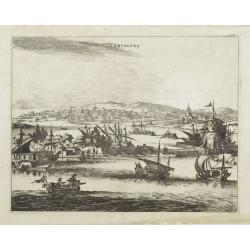
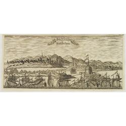
Cartagena.
A richly colored view of what was at the time one of the most important and largest cities in Spanish America. As a result, Cartagena was heavily defended, as is evidence...
Date: London, ca 1671
Selling price: ????
Please login to see price!
Sold in 2022
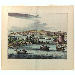
Cartagena.
Attractive view of the treasure port of Cartagena in what is now Colombia.A variety of boats and ships dominate the foreground with the town and its surroundings depicted...
Date: Amsterdam, 1671
Selling price: ????
Please login to see price!
Sold
Terra Firma et Novum Regnum Granatense et Popayan.
Detailed map of Panama and northwestern South America derived from the Blaeu/Jansson map of the regionFeaturing ships at sea, two compass roses, and two cartouches depict...
Date: Amsterdam, 1673
Selling price: ????
Please login to see price!
Sold in 2025
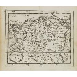
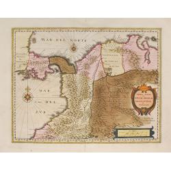
Castille d\'Or.
Uncommon miniature map of Columbia from Pierre Duval\'s La Geographie Universeille dated 1676. Following his Cartes de géographie in 1657, Pierre Duval published this sm...
Date: Paris, 1676
Selling price: ????
Please login to see price!
Sold in 2008
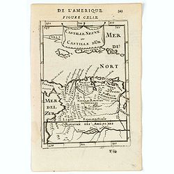
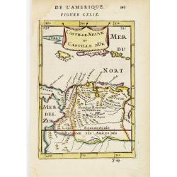
Castille Neuve ou Catille d'Or.
A charming map of Venezuela and Colombia. Includes also Jamaica and Puerto Rico. etc. Title in curtain draped at top. French text on verso.From the original 1683 text edi...
Date: Paris, 1683
Selling price: ????
Please login to see price!
Sold in 2022
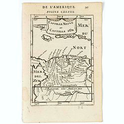
Castille Neuve ou Catille d'Or.
A charming map of Venezuela and Colombia. Includes also Jamaica and Puerto Rico. etc. Title in curtain draped at top. French text on verso.From the original 1683 text edi...
Date: Paris, 1683
Selling price: ????
Please login to see price!
Sold in 2020
Castille Neuve ou Castille d' Or.
Copperplate engraved map showing Venezuela, partly Columbia, Jamaica, Hispaniola and Puerto Rico.From the French text edition of Description d'Univers, 1683. by Allain Ma...
Date: Paris, 1683
Selling price: ????
Please login to see price!
Sold
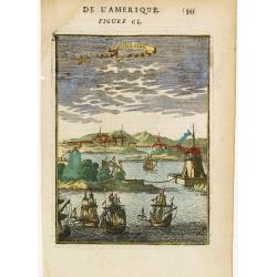
Carthagene.
Charming view of Cartagena in the Bolivar region, Colombia. Depicted with many vessels entering the harbour.From the French text edition of Description d'Univers, 1683. b...
Date: Paris 1683
Selling price: ????
Please login to see price!
Sold
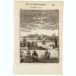
Carthagene.
A charming panoramic view of Cartagena in Colombia. Ships in the fore ground. Title in curtain draped at top. French text on verso.From the original 1683 text edition of ...
Date: Paris, 1683
Selling price: ????
Please login to see price!
Sold
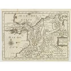
Terre Ferme et Nouv. Royaume de Grenade et Popaian.
Charming and uncommon map of today territory of Colombia. Decorated with a compass rose and title cartouche.
Date: Amsterdam, 1700
Selling price: ????
Please login to see price!
Sold in 2015
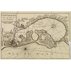
CARTAGENE Avec ses Ports et ses FORTS.
Decorative map of Cartagena, fortified colonial harbour in Colombia.
Date: Amsterdam 1722
Selling price: ????
Please login to see price!
Sold
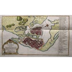
Plan de la Ville de Carthagene des Indes.
Nice map of the city of Cartegena and Magna Island in Columbia. It has a decorative title cartouche and the key places are identified in the index to the right.
Date: Paris, 1735
Selling price: ????
Please login to see price!
Sold in 2015
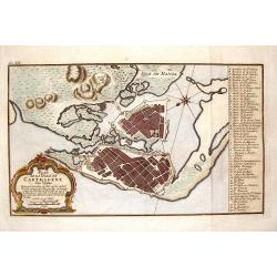
Plan de la Ville de Carthagene des Indes.
Striking and highly detailed Bellin's copper engraved areal plan of Cartagena and Cartagena Bay, mapped by Antonio de Ulloa en 1735.The full color map presents a key list...
Date: Paris, 1735
Selling price: ????
Please login to see price!
Sold in 2015
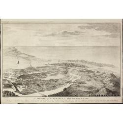
A Prospect of Carthagena, Taken from Madre de la Popa.
Very rare view of Cartagena de IndiasThis English copper engraved view of Cartagena in Colombia was drawn by an unidentified J. Norden and engraved by William Henry Toms,...
Date: London, 1743
Selling price: ????
Please login to see price!
Sold in 2010
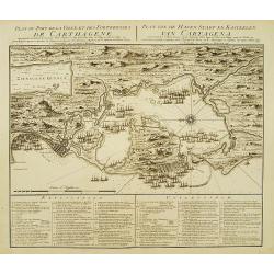
Plan du Port de la Ville et des Forteresses de Carthagène..
Highly decorative plan of the bay and fortifications of Cartagena in Colombia during the siege by the British fleet. Table of explanations in French and Dutch below. Nort...
Date: Amsterdam c. 1745
Selling price: ????
Please login to see price!
Sold
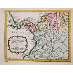
Carte des Provinces de Tierra Firme, Darien, Cartagene et Nouvelle Grenade.
Jaques Nicolas Bellin (1702-720) was the most important French hydrographer of the 18th century. Sea-atlas 'Hydrographique Français' , 1756-65, atlas to accompany Prévo...
Date: Paris, 1756
Selling price: ????
Please login to see price!
Sold in 2008
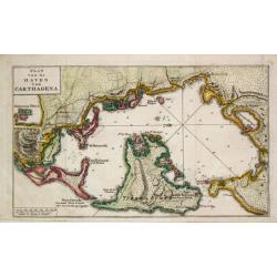
Plan van de Haven van Carthagena.
Izaak Tirion (d. 1769) Amsterdam publisher. His ' Nieuwe en beknopte handatlas' saw 6 editions between before 1740 and after 1784. Also ' Tegenwoordige staat van alle vol...
Date: Amsterdam, 1765
Selling price: ????
Please login to see price!
Sold
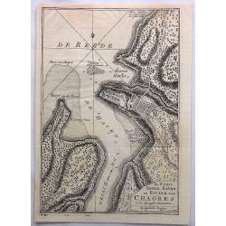
De Stad, Reede, Haven en Rivier van Chagres in de Spaansche Westindien.
A map of the town of Chagres and its direct vicinity. The Chagres River in central Panama is the largest in the Panama Canal's watershed.It was published in “Tegenwoord...
Date: Amsterdam, 1765
Selling price: ????
Please login to see price!
Sold in 2017
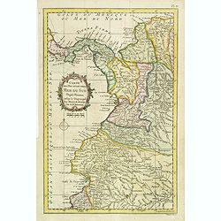
Carte des Pays situés sur la Mer du Sud. . .
Detailed map of Panama, Colombia and Ecuador. The map was prepared by William Roberts (1721-1793) in 1777 for the English edition, in 1778 the first French edition follow...
Date: Paris, Panckoucke, 1778
Selling price: ????
Please login to see price!
Sold in 2011
Map of the Countries of the South Sea from Panama to Guayquil.
A striking map of Central America, including Columbia, Ecuador, Panama, the New Kingdom of Granada and Quito. From Dr. Robertson's 'History of America'.Thomas Kitchin (17...
Date: London, 1795
Selling price: ????
Please login to see price!
Sold in 2018
Die Stadt Carthagena in West Indien.
Panoramic view of the town of Cartagena in present-day Colombia, with a variety of boats and ships who dominate the foreground with the town and its surroundings depicted...
Date: Zittau, 1798 - 1800
Selling price: ????
Please login to see price!
Sold in 2013
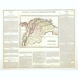
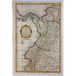
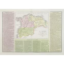
Geographical, Statistical, and Historical Map of Colombia.
One of the first separate maps of the newly independent Colombia and Venezuela, which was still steeped in Revolution under the irrepressible work of Simon Bolivar. The m...
Date: Philadelphia, 1822
Selling price: ????
Please login to see price!
Sold in 2020
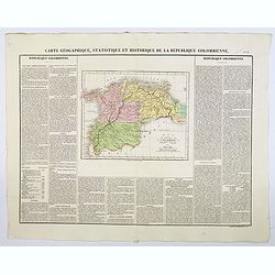
Carte Geographique, Statistique et Historique de la Republique Colombienne.
A nice detailed map of Columbia from Buchon's Atlas Gégraphique Statistique, historique et chronologique des deux Ameriques et des isles adjacentes traduit de l'atlas ex...
Date: Paris, 1825
Selling price: ????
Please login to see price!
Sold in 2019
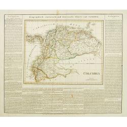
Columbia.
This is the map of Columbia is from a plano edition of the very scarce German edition of Carey & Lea's "A Complete Historical, Chronological, and Geographical Am...
Date: Weimar, 1822-1825
Selling price: ????
Please login to see price!
Sold
![[ Air volcanoes of Turbaco in Colombia ].](/uploads/cache/27272-250x250.jpg)
[ Air volcanoes of Turbaco in Colombia ].
Aquatint depicting air volcanoes of Turbaco near Cartagena in Colombia.Engraved by Fumagalli.From Giulio Ferrario's work Le Costume Ancien et Moderne ou Histoire du gouve...
Date: Milan, 1827
Selling price: ????
Please login to see price!
Sold in 2009
![[ Tequendama Falls in Colombia ].](/uploads/cache/27269-250x250.jpg)
[ Tequendama Falls in Colombia ].
Aquatint depicting the Tequendama Falls in Colombia. The Tequendama Falls is a high waterfall on the Bogotá River, southwest of Bogotá. Engraved by Fumagalli. From Giul...
Date: Milan, 1827
Selling price: ????
Please login to see price!
Sold in 2009
![[ Two natural bridges in Colombia ].](/uploads/cache/27268-250x250.jpg)
[ Two natural bridges in Colombia ].
Aquatint depicting two natural bridges in Colombia. Engraved by Fumagalli.From Giulio Ferrario's work Le Costume Ancien et Moderne ou Histoire du gouvernement, de la mili...
Date: Milan, 1827
Selling price: ????
Please login to see price!
Sold in 2009
![[ River Vinagre Waterfall, near the Puraci Volcano].](/uploads/cache/27267-250x250.jpg)
[ River Vinagre Waterfall, near the Puraci Volcano].
Aquatint depicting Rio Vinagre (Sour River) Waterfall. Engraved by Fumagalli.From Giulio Ferrario's work Le Costume Ancien et Moderne ou Histoire du gouvernement, de la m...
Date: Milan, 1827
Selling price: ????
Please login to see price!
Sold in 2009
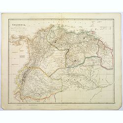
Colombia.
A large, detailed steel engraved map of the South American state of Colombia. This map of Colombia extends into modern day Venezuela to the east, and Ecuador to the south...
Date: London, 1839
Selling price: ????
Please login to see price!
Sold in 2020
La Colombia . . .
A rare and detailed double-page map of Colombia, Bolivia and Venezuela. The map is surrounded by an explanatory historical text about the countries in pink, yellow and gr...
Date: Venice, 1840
Selling price: ????
Please login to see price!
Sold in 2011
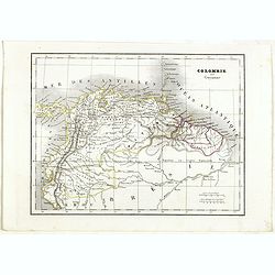
Colombie et Guyanne.
Detailed map of Colombia and Guyana / Surinam, prepared by Charles V. Monin (fl.1830-1880) a French cartographer of Caen and Paris. Published in Atlas Universel de Géogr...
Date: Paris, 1845
Selling price: ????
Please login to see price!
Sold in 2019
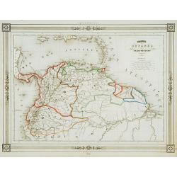
Colombie et Guyanes..
Decorative map of Colombia, Venezuela, Surinam, prepared by J.G.Barbié du Bocage.Engraved by Ch.Smith, published by Basset who was established in Paris, rue de Seine 33....
Date: Paris 1846
Selling price: ????
Please login to see price!
Sold
