Browse Listings in America > South America > Argentina
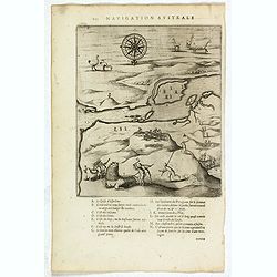
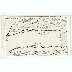
Untitled map of Port Desire (today's Puerto Deseado, Argentina)
Scarce untitled map of Port Desire (today’s Puerto Deseado, Argentina). From a description of the voyage of Le Maire and Schouten included in the first French text editi...
Date: Amsterdam, 1622
Selling price: ????
Please login to see price!
Sold in 2018
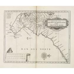
Provincia Sitæ Ad Fretum Magallanis itemque Fretum Le Maire.
Detailed map of the southern tip of South America, with coastline and Strait of Magellan from Tierra del Fuego to southern Argentina.Scarce map prepared by Hessel Gerrits...
Date: Leiden, Elzevier, 1625
Selling price: ????
Please login to see price!
Sold in 2013
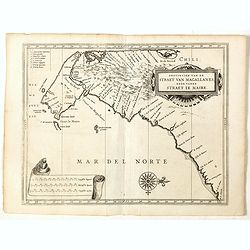
Provinciae sitae ad Fretum Magallanis itemque Fretum Le..
Detailed map of the southern tip of South America, prepared by Hessel Gerritsz, the official map maker for the Dutch West India Company. Gerritsz enjoys a very high reput...
Date: Leiden 1630
Selling price: ????
Please login to see price!
Sold in 2011
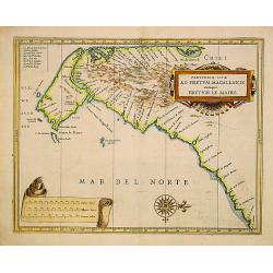
Provincia Sitæ Ad Fretum Magallanis itemque Fretum Le Maire.
Detailed map of the southern tip of South America, with coastline and Strait of Magellan from Tierra del Fuego to southern Argentina.Scarce map prepared by Hessel Gerrits...
Date: Leiden, Elzevier, 1630
Selling price: ????
Please login to see price!
Sold in 2019
![[Cavendish reaches Deseado.]](/uploads/cache/39906-250x250.jpg)
[Cavendish reaches Deseado.]
Scarce print with a German text sheet. In December, 1586, during his round-the-world voyage, Cavendish’s fleet landed on the Atlantic coast of Patagonia, near some island...
Date: Frankfurt, M.Merian, 1633
Selling price: ????
Please login to see price!
Sold in 2017
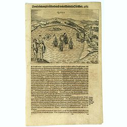
Quintero.
Scarce print with a German text sheet. On 13th June, 1615, Spilbergen’s fleet entered the beautiful Bay of Quintero (A), and anchored there (C). Again the Dutch went asho...
Date: Frankfurt, M.Merian, 1633
Selling price: ????
Please login to see price!
Sold in 2017
![[Drake reaches the Rio de la Plata].](/uploads/cache/39915-250x250.jpg)
[Drake reaches the Rio de la Plata].
Scarce print with a German text sheet showing Drake’s fleet of five ships reaching the Rio de la Plata in April, 1578. One of the ships in poor repair had been slowing th...
Date: Frankfurt, M.Merian, 1633
Selling price: ????
Please login to see price!
Sold in 2017
![[First Spanisn colony at Buenos Aires.]](/uploads/cache/40084-250x250.jpg)
[First Spanisn colony at Buenos Aires.]
In 1534 Pedro de Mendoza was sent to colonise the Rio de la Plata. The following year, several hundred men began to colonise the present day site of Buenos Aires. At firs...
Date: Frankfurt, M.Merian, 1633
Selling price: ????
Please login to see price!
Sold in 2017
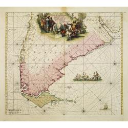
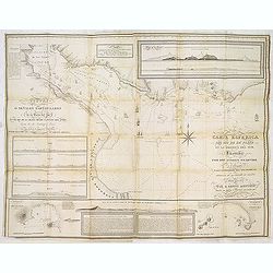
(The coast of Argentina from Cape S. Andreas to Golfo San Jorge.)
A chart from Robert Dudley's sea-atlas Arcano del Mare. It depicts the coast of Argentina from Cape S. Andreas in lattitude 39 o S. to Golfo San Jorge.Robert Dudley (1574...
Date: Florence, 1661
Selling price: ????
Please login to see price!
Sold in 2019
Carta particolare d'Argentina che comincia con il capo S. Andrea e¨ finisce con il capo Matas d'America.
Robert Dudley (1574-1649). English cartographer. The Arcano del Mare (Mystery of the Sea) is "ONE OF THE GREATEST ATLASES OF THE WORLD": it is the first sea-atl...
Date: Florence, 1661
Selling price: ????
Please login to see price!
Sold in 2019
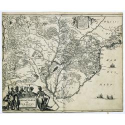
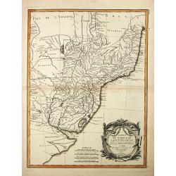
Paraquaria vulgo Paraguay cum adjacentibus.
Detailed map extending from Rio de Janeiro to the Rio de la Plata basin in what is today Argentina.The title cartouche of this highly decorative map features Indians and ...
Date: Amsterdam, 1673
Selling price: ????
Please login to see price!
Sold in 2022
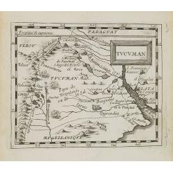
Tucuman.
Uncommon miniature map of part of Argentina, centered on Buenos Aires and Rio La Plata, from Pierre Duval's La Geographie Universeille dated 1676. Following his Cartes de...
Date: Paris, 1676
Selling price: ????
Please login to see price!
Sold in 2008
Tractus Australior Americae Meridionalis a Rio de la Plata per Fretum Magellanicaum ad Toraltum . . .
A decorative chart of the southern coast of Chile and Argentina from Toral to Rio del Plata. A large vignette battle scene occupies the South Atlantic and the title is se...
Date: Amsterdam, 1680
Selling price: ????
Please login to see price!
Sold in 2009
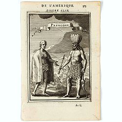
Patagons.
A charming print of a Patagonian couple. Title in curtain draped at top. French text on verso.From the original 1683 text edition of "Description d'Univers. . ."...
Date: Paris, 1683
Selling price: ????
Please login to see price!
Sold in 2022

Patagons.
Copperplate engraved image of two very different natives from the region of Patagonia.From the French text edition of Description d'Univers, 1683. by Allain Manneson Mall...
Date: Paris 1683
Selling price: ????
Please login to see price!
Sold
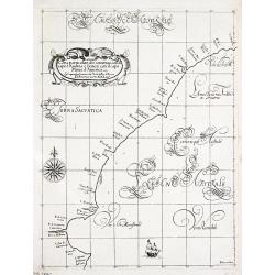
Isle du Prince.
Simplified bird's-eye view of "Isle du Prince" in present-day Argentina.From volume two of the French reissue of the account of early Dutch voyages. The French ...
Date: Amsterdam, E. Roger, 1703
Selling price: ????
Please login to see price!
Sold in 2013
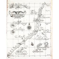
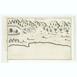
Porto il Desire.
Simplified bird's-eye view of Port Desire or Puerto Deseado in present-day Argentina.From volume two of the French reissue of the account of early Dutch voyages. The Fren...
Date: Amsterdam, E. Rogers, 1703
Selling price: ????
Please login to see price!
Sold in 2013
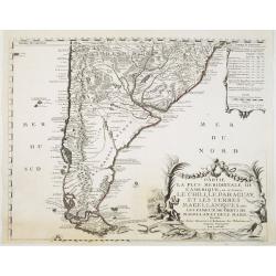
Partie la plus Meridionale de L'Amerique..
Striking map of the southern tip of South America: Prepared by Nicolas de Fer and published by Danet. Engraved by De Rochefort (signed lower right). The map shows the maj...
Date: Paris, Danet, 1737
Selling price: ????
Please login to see price!
Sold in 2022
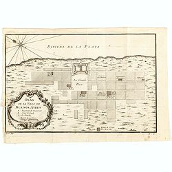
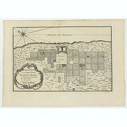
Plan de la Ville de Buenos Ayres.
The early layout of the town of Buenos Aires is shown in blocks, with a few of the important buildings named. Rococo title cartouche at lower left.Jacques Nicolaas Bellin...
Date: Paris, 1749
Selling price: ????
Please login to see price!
Sold in 2016
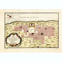
Plan de la Ville de Buenos Ayres.
The early layout of the town of Buenos Aires is shown in blocks, with a few of the important buildings named. Rococo title cartouche at lower left.Jacques Nicolaas Bellin...
Date: Paris, 1750
Selling price: ????
Please login to see price!
Sold in 2014
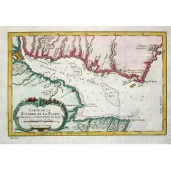
Carte de la Riviere de la Plata.
Jaques Nicolas Bellin (1702-720) was the most important French hydrographer of the 18th century. Sea-atlas 'Hydrographique Français' , 1756-65, atlas to accompany Prévost...
Date: Paris, c. 1755
Selling price: ????
Please login to see price!
Sold

Carte de la Riviere de la Plata.
Jaques Nicolas Bellin (1702-720) was the most important French hydrographer of the 18th century. Sea-atlas 'Hydrographique Français' , 1756-65, atlas to accompany Prévost...
Date: Paris, c. 1755
Selling price: ????
Please login to see price!
Sold
Grundriss von der Stadt Buenos-Ayres.
The early layout of the town of Buenos Aires is shown in block formation, with a few of the important buildings named, these include: the Governor's Residence, the City H...
Date: Leipzig, 1758
Selling price: ????
Please login to see price!
Sold in 2023
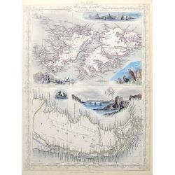
![[Lot of 11 maps and views of the Falkland islands and the Argentinian part of Terra del Fuega. ]](/uploads/cache/20422-(2)-250x250.jpg)
[Lot of 11 maps and views of the Falkland islands and the Argentinian part of Terra del Fuega. ]
Rigobert Bonne (1727-1795), French cartographer. His maps are found in a.o. Atlas Moderne (1762), Raynal's Histoire Philos. du Commerce des Indes (1774) and Atlas Encyclo...
Date: Paris, 1762
Selling price: ????
Please login to see price!
Sold in 2022
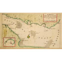
De Ingang van Rio de la Plata, Waar aan de Stad Buenos Ayres ligt, in Zuid-Amerika.
A map showing the Rio de la Plata estuary with the town of Buenos Aires. With an inset depicting the Bay of Maldonado.
Date: Amsterdam, 1765
Selling price: ????
Please login to see price!
Sold
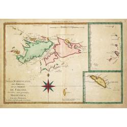
Isles Maidenland, de Hawkins et le Détroit de Falkland. / Isle de Géorgie. / Terre de Sandwich.
Rigobert Bonne (1727-1795), French cartographer. His maps are found in a.o. Atlas Moderne (1762), Raynal's Histoire Philos. du Commerce des Indes (1774) and Atlas Encyclo...
Date: Paris, 1774
Selling price: ????
Please login to see price!
Sold
![Carte de Maidenland ou de la Virginie de Hawkins, Découverte par Sir Richard Hawkins en 1574, et du Canal Falkland . . . [Tome I Pl.7.]](/uploads/cache/25892-250x250.jpg)
Carte de Maidenland ou de la Virginie de Hawkins, Découverte par Sir Richard Hawkins en 1574, et du Canal Falkland . . . [Tome I Pl.7.]
Chart shows the Falkland Islands and the Falkland Straits discovered by Sir Richard Hawkins in 1574. Shows many harbors, channels, capes, bays, shoals, islands, rocks, so...
Date: Paris, 1774
Selling price: ????
Please login to see price!
Sold in 2021
Carte du Paraguay et partie des Pays adjacants.
Jean Lattré, Paris-based engraver and publisher. Worked with Robert de Vaugondy, J. Janvier and R. Bonne. " Atlas Monderne', 1771, 1783 , 1793. Rigobert Bonne (1727-...
Date: Paris, 1783
Selling price: ????
Please login to see price!
Sold
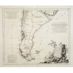
Carte du Chili Méridional, du Rio de la Plata, des Patagons, et du Détroit de Magellan. . .
Finely and crisply engraved map representing the southern tip of South America. It extends northwards as far as the river de la Plata estuary.Venetian edition of d\'Anvil...
Date: Venice, 1776 - 1784
Selling price: ????
Please login to see price!
Sold in 2008
![[Lot of 11 maps of the Strait of Magellan] Carte du detroit de Magellan avec les Routes de la Bodeuse et de l'Etoile.](/uploads/cache/19991-(3)-250x250.jpg)
[Lot of 11 maps of the Strait of Magellan] Carte du detroit de Magellan avec les Routes de la Bodeuse et de l'Etoile.
Carte du Detroit de Magellan avec les Routes de la Bodeuse et de l'Etoile taken by the French discoverer Comte de Bougainvile, L.A. With in addition 10 maps / prints of ...
Date: Paris, c. 1790
Selling price: ????
Please login to see price!
Sold in 2022
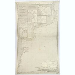
Carta esférica del Rio de la Plata en la América del Sur, Levantada por Don Andres Oyarvide. . .
Stunning chart of the Rio de la Plata with Buenos Aires, Montevideo, Maldonado, etc. prepared by Benito Aizpurúa. The map has several insets including "Puerto de Mon...
Date: Buenos Aires, ca.1823
Selling price: ????
Please login to see price!
Sold in 2013
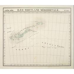
Iles Shetland Méridionale. No.43.
PLANO sheet map covering The South Sandwich Islands. From his famous Atlas Universel. This atlas was one of the most remarkable world atlases ever produced, anticipating ...
Date: Brussels, 1825-1827
Selling price: ????
Please login to see price!
Sold
![Partie de la Patagonie. No.39. [With text on Chili]](/uploads/cache/09074-250x250.jpg)
Partie de la Patagonie. No.39. [With text on Chili]
PLANO sheet map covering a tip of the southern part of Argentina, mainly showing Valdés Peninsula. With a text block dealing with Chile. From his famous Atlas Universel. ...
Date: Brussels, 1825-1827
Selling price: ????
Please login to see price!
Sold
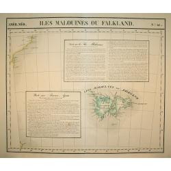
Isles Malouines ou Falkland. No.41.
PLANO sheet map covering The Falkland Islands, including small tip of Argentina's coast. With a text block dealing with the area and one with Buenos Ayres. From his famou...
Date: Brussels, 1825-1827
Selling price: ????
Please login to see price!
Sold in 2009
![[ View of Buenos Aires ].](/uploads/cache/27301-250x250.jpg)
[ View of Buenos Aires ].
Aquatint depicting a view of Buenos Aires from the seashore.Engraved by Fumagalli.From Giulio Ferrario's work Le Costume Ancien et Moderne ou Histoire du gouvernement, de...
Date: Milan, 1827
Selling price: ????
Please login to see price!
Sold in 2009
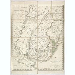
Carta geographica que comprende los rios de la plata, parana, uruguay y grande. . .
Rare separately issued map of parts of Uruguay, with parts of Brazil, Argentina and Paraguay. This map focuses on the extensive river system in southeastern South America...
Date: London, 1827
Selling price: ????
Please login to see price!
Sold in 2013
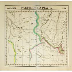
Partie de la Plata. No.34
PLANO sheet map covering Buenos Ayres. From his famous Atlas Universel . This atlas was one of the most remarkable world atlases ever produced, anticipating the Internati...
Date: Brussels, 1825-1827
Selling price: ????
Please login to see price!
Sold in 2009
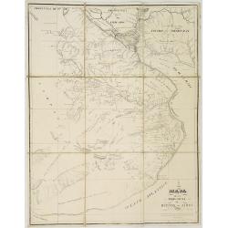
Mapa de la Provincia de Buenos-Aires.
Folding-map of the city of Buenos Aires in Argentina. Cesár Hipólito Bacle, Swiss engraver and litographer, established the first lithographic shop in Buenos Aires.
Date: Buenos-Aires, 1833
Selling price: ????
Please login to see price!
Sold in 2008
Carta esférica del Rio de la Plata...
Large nautical chart.
Date: Madrid 1812-1838
Selling price: ????
Please login to see price!
Sold
Falkland Islands and Patagonia.
Two very decorative steel-engraved maps on one sheet. Both maps are very detailed with place names, rivers, hills, islands, bays, etc.Attractively illustrated with vignet...
Date: London, ca. 1850
Selling price: ????
Please login to see price!
Sold in 2020
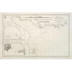
Carte d'une partie des Cotes Orientales de L'Amerique Meridionales. . .
A large marine chart of the eastern coast of Argentina, from the mouth of the River Plate, south to the Gulf of St. George. Filled with nautical information depth levels,...
Date: Paris, 1851
Selling price: ????
Please login to see price!
Sold in 2019
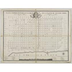
Plano Topografico de las Calles de la Ciudade de Buenos-Aires. . .
Folding-map of Buenos Aires Inset of the city sky line with a key map.
Date: ca. 1870
Selling price: ????
Please login to see price!
Sold in 2008
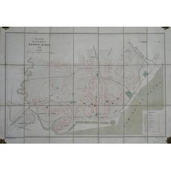
Plano de la Ciudad de Buenos-Aires.
Folding plan of Buenos Aires orientated with north towards the right edge, scale c. 1½ inches to 1 kilometre. Original color to water and parks, street names printed in r...
Date: (Offered by the Pintureria of Monserrat, Buenos Aires). 1890
Selling price: ????
Please login to see price!
Sold in 2012
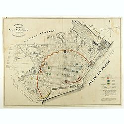
Plano de la capital para el trafico general de conformidad con la ordenanza 3 Agosto 1897.
City plan of Buenos Ayres in August 1897. With a color key in lower right corner.
Date: Italy, 1897
Selling price: ????
Please login to see price!
Sold in 2018
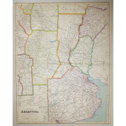
Central Argentina.
A large scale map of Argentina by George Philip & Son The map shows provincial boundaries, and is very high in contemporary detail.Published in London for The London ...
Date: London, 1900
Selling price: ????
Please login to see price!
Sold in 2016
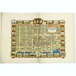
Buenos Aires Capital de La Republica Argentina. Una Nacion Socialmente Justa Economicamente Libre. . .
A beautiful pictorial town plan of the Argentinian Capital Buenos Aires, as published in 1950. The downtown area of side streets and attractive wide avenues are covered w...
Date: Buenos Aires, ca 1950
Selling price: ????
Please login to see price!
Sold in 2019
