Browse Listings in America > South America
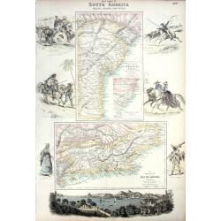
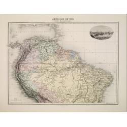
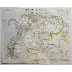
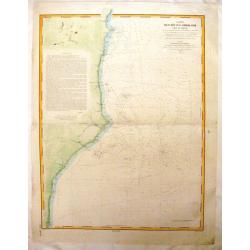
EAST COAST OF SOUTH AMERICA; BRAZIL, MIDDLE PROVINCES
Excellent lithograph published by Fullarton. Shows two maps of Brazil: "East Coast of Brazil" & "Province of Rio de Janeiro" both by H.Mahlmann a...
Date: London, Edinburgh, Dublin, c.1861
Selling price: ????
Please login to see price!
Sold
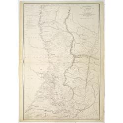
Carte de la République du Paraguay (cours du Parana et du Paraquay) . . .
Large, detailed and rare map of Paraguay prepared by Ernest Amédée Barthélemy Mouchez. According to the title the information was gathered during his voyages in 1857 - 18...
Date: Paris, Logerot, 1862
Selling price: ????
Please login to see price!
Sold
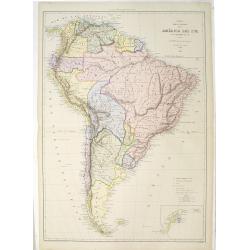
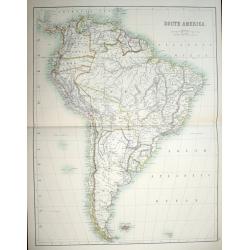
Mapa fisica y politica de la América del Sur. . .
Large and uncommon lithographed map of South America prepared by A.Vuillemin and A.Logerot and printed by Gratia. Most names in Spanish. In lower right corner an inset ma...
Date: Paris, A.Logerot / F.Brachet, 1867
Selling price: ????
Please login to see price!
Sold in 2011
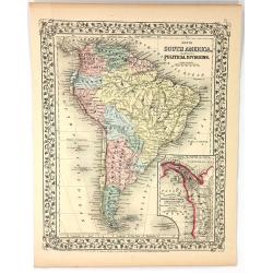
Map of South America Showing its Political Divisions
A pleasing map of South America, with attention to both political and geographical elements. Complete with inset of the Atrato-Inter-Oceanic Canal Routes. The map is sur...
Date: Philadelphia, 1867
Selling price: ????
Please login to see price!
Sold in 2016
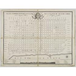
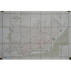
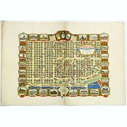
Plano Topografico de las Calles de la Ciudade de Buenos-Aires. . .
Folding-map of Buenos Aires Inset of the city sky line with a key map.
Date: ca. 1870
Selling price: ????
Please login to see price!
Sold in 2008
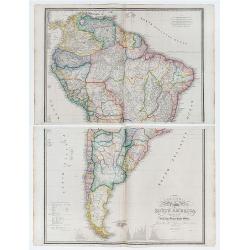
Colombia Prima or South America drawn from the large map in eight sheets by Louis Stanislav D'Arcy Delarochette.
2 large double page engraved maps (each 53 x 76 cm overall sheet 56 x 86 and if joined combining to make an overall sheet size of c.110 x 86 cm) with original outline col...
Date: London: James Wyld. Geographer toHer Majesty Charing Cross East. 1870
Selling price: ????
Please login to see price!
Sold in 2020
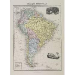
Amérique Méridionale.
Decorative map of South America from Géographie Universelle, Atlas Migeon. With an inset map of the Galapagos Islands. Published by J. Migeon. Engraved by Sengteller.From...
Date: Paris, 1874
Selling price: ????
Please login to see price!
Sold in 2022
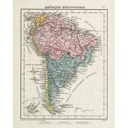
Amérique Méridionale.
Attractive 19th century map of the South American continent. Small inset of the Galapagos Islands in the lower left corner.
Date: Brussel, ca. 1875
Selling price: ????
Please login to see price!
Sold in 2011
Amérique du Sud (Partie Septentrionale)
Map showing the northern part of South America, from the state of Panama as far as Bolivia and the Minas Gerais state in Brazil.It presents the Lesser Antilles on top as...
Date: Paris, 1875
Selling price: ????
Please login to see price!
Sold in 2008
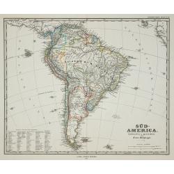
Süd-America.
Map of South-America, published in Stieler's Hand Atlas .
Date: Gotha, 1875
Selling price: ????
Please login to see price!
Sold in 2011
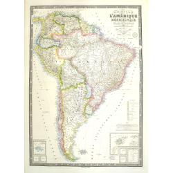
Nouvelle carte de l'Amérique Méridionale et des iles qui en dépendent Dédié à l'Academie Imp.le des Sciences de l'Institut de Franc. . . . 1876
Very large, highly detailed and scarce issue of the map of South America prepared by A. Vuillemin after Adrien Hubert Brué (1786-1832). The map has shipping lines added a...
Date: Paris, 1875
Selling price: ????
Please login to see price!
Sold in 2018
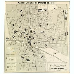
Plano de la Ciudad de Santiago de Chile.
A nice sized plan of the Chilean capital of Santiago towards the end of the nineteenth century. This orderly plan lays out the cities divisions and sub divisions, churche...
Date: Santiago, ca 1878
Selling price: ????
Please login to see price!
Sold in 2016
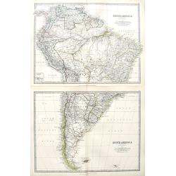
South America (Northern Sheet + Southern Sheet).
A large map on two sheets of all of South America. A small inset map shows the Galapagos Islands. Excellent maps with fantastic detail.
Date: Edinburgh, 1878
Selling price: ????
Please login to see price!
Sold in 2018
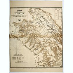
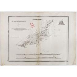
Carta de la Hoya del Lago Titicaca...Oceano Pacifico.
Map of the region surrounding Lake Titicaca in Peru. Map shows roads, railways, major, and minor towns, mineral mines, and the physical geography of the region. Map has a...
Date: Santiago, 1879
Selling price: ????
Please login to see price!
Sold in 2016
Carte .. De la Patagonie et de la Terre de Feu..
Very detailed map of Strait of Magellan, prepared by J.Grange.Engraved by Jacobs. With a color key to soil conditions.
Date: Paris c.1880
Selling price: ????
Please login to see price!
Sold
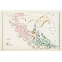
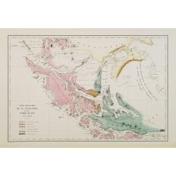
Carte géologique de la Patagonie et de la Terre de Feu.
Very detailed geological map of Strait of Magellan, prepared by J.Grange.Engraved by Jacobs. With a color key to soil conditions.From "Voyage au Pôle Sud et dans l'O...
Date: Paris c.1880
Selling price: ????
Please login to see price!
Sold in 2010
![[Lot of 12 maps and prints relating to Surinam and South America and map of The Netherlands]](/uploads/cache/48306-250x250.jpg)
[Lot of 12 maps and prints relating to Surinam and South America and map of The Netherlands]
A lot of 12 maps and prints of Surinam, South America and one of the Netherlands. Including Bellin's maps of "Carte de l'Isle de Cayenne et de ses Environs (205x285m...
Date: Netherlands, Paris, ca. 1700-1880
Selling price: ????
Please login to see price!
Sold in 2022
Set of 6 maps South America.
A set of 6 highly detailed colored maps of the different countries that go to make up the whole of South America.Each map with a color key to British Consulates and Briti...
Date: London, 1881
Selling price: ????
Please login to see price!
Sold in 2020
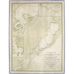
Carta das Lagoas dos Patos, Mirim e dos Canaes que as ligao a Barra do Rio Grande do Sul..
Large lithography illustrating the coastal area of the Brazilian state "Rio Grande do Sul", namely the 2 large lagoons Merin and dos Patos.With 3 inset maps sup...
Date: Rio de Janeiro, 1882
Selling price: ????
Please login to see price!
Sold in 2013
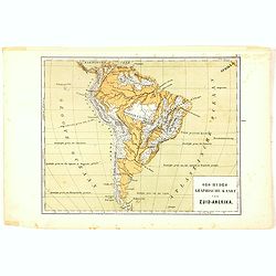
Oro-Hydrographische Kaart van Zuid-Amerika.
One of the earliest thematic maps of South America published in the Netherlands from "Atlas der natuurkundige aardrijkskunde. . .". prepared by Nicolaas Wilhelm...
Date: Amsterdam, C.L. Brinkman, 1883
Selling price: ????
Please login to see price!
Sold in 2020
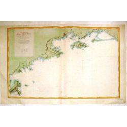
Carte Particuliere de la Cote du Bresil.
Large detailed map of the coast of Brazil from The Bay of Sapetiba to the Island of Sao Sebastia. It was priced at two francs when produced. Depot de la Marine (1720 - ...
Date: Paris, 1884
Selling price: ????
Please login to see price!
Sold in 2013
Carte des rcifs Arbrohos (Cote du Bresil).
Large detailed marine chart of the coast of Brazil from San Mateo to the Itacolomis. The cost of the chart was printed on the map and was two francs. Depot de la Marine...
Date: Paris, 1887
Selling price: ????
Please login to see price!
Sold in 2015
(A set of six maps of Central & South America)
This beautiful set of maps were made by Adam and Charles Black in 1889 for the library edition of "The Scribner-Black Atlas of the World" And also for "Bla...
Date: Edinburgh, 1889
Selling price: ????
Please login to see price!
Sold in 2014
Plano de la Ciudad de Buenos-Aires.
Folding plan of Buenos Aires orientated with north towards the right edge, scale c. 1½ inches to 1 kilometre. Original color to water and parks, street names printed in r...
Date: (Offered by the Pintureria of Monserrat, Buenos Aires). 1890
Selling price: ????
Please login to see price!
Sold in 2012
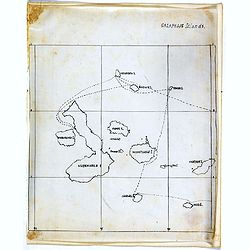
Galapagos Islands.
An unusual small, and basic manuscript map of the Galapagos Islands in the Pacific Ocean, off the coast of South America. It looks as though the map depicts an explorers ...
Date: London, ca. 1890
Selling price: ????
Please login to see price!
Sold in 2017
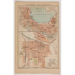
Valparaiso und Santiago.
Eye-bird view of Valparaiso bay, together with a city plan of Santiago. The print has been printed by F.A.Brockhaus Geogr. - artist. Anstalt, Germany in 1895.
Date: Germany, 1895
Selling price: ????
Please login to see price!
Sold in 2020
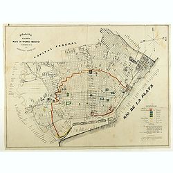
Plano de la capital para el trafico general de conformidad con la ordenanza 3 Agosto 1897.
City plan of Buenos Ayres in August 1897. With a color key in lower right corner.
Date: Italy, 1897
Selling price: ????
Please login to see price!
Sold in 2018
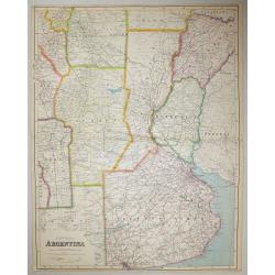
Central Argentina.
A large scale map of Argentina by George Philip & Son The map shows provincial boundaries, and is very high in contemporary detail.Published in London for The London ...
Date: London, 1900
Selling price: ????
Please login to see price!
Sold in 2016
![[Detailed folding map of Nickerie River, Nickerie, Coronie in Suriname]](/uploads/cache/47218-250x250.jpg)
[Detailed folding map of Nickerie River, Nickerie, Coronie in Suriname]
Detailed folding map of Nickerie River, Nickerie, Coronie in Suriname. The Nickerie is a river in the northwestern part of Suriname. The river originates in the Bakhuis M...
Date: Surinam, or Netherlands, ca. 1900
Selling price: ????
Please login to see price!
Sold in 2022
Mensura de las minas.
Pen and ink drawing of mines in South America by Belisaeio Vergara and other sources of the mines "Porvenir", "Defensa" and "Amparo" in Chil...
Date: Chile, 1906
Selling price: ????
Please login to see price!
Sold in 2014
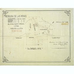
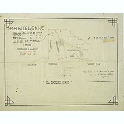
Mensura de las minas. . . Choquelimpie. (manuscript map)
Pen and ink drawing of the mines "Porvenir", "Defensa" and "Amparo" in Choquelimpe region in Chili by Belisaeio Vergara and E.Basadre Forero...
Date: Chile, Choquelimpie, 19 December 1906
Selling price: ????
Please login to see price!
Sold in 2015
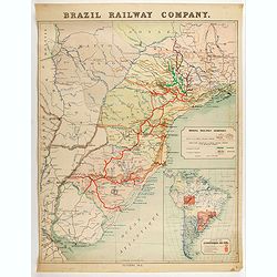
Brazil Railway Company.
Map of Brazil railway structure, from Rio de Janeiro to Rio de la Plata. Including a map of general South America. The map also shows part of Paraguay and Argentina.
Date: London, 1912
Selling price: ????
Please login to see price!
Sold in 2020
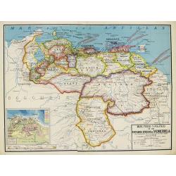
Mapa Fisico y Politico de los Estados Unidos de Venezuela..
Very large fold-out map of Venezuela, including part of Colombia, Brazil and Guyana. With inset front view of the tallest mountains from the Sierra Nevada to Mount Roraim...
Date: Paris, 1934
Selling price: ????
Please login to see price!
Sold in 2019
Ocean glacial Antartique - Mers du Cap Horn . . .
Large chart representing the Cap Horn sea, part of Patagonia, Falkland Islands and Palmer Archipelago. A couple of places are highlighted in red.
Date: Paris, 1916 updated to 1934
Selling price: ????
Please login to see price!
Sold in 2022
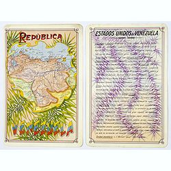
Republica de Venezuela.
A beautiful hand colored, hand drawn map of Venezuela, prepared for the Buenos Aires 1939 Philatelic Exhibition, with separate text with details of the country in Spanish...
Date: Buenos Aires, 1939
Selling price: ????
Please login to see price!
Sold in 2019
Océan Atlantique Sud, ile de Fernando-Noronha.
Striking and highly detailed chart of Fernando de Noronha, an archipelago of 21 islands and islets in the Atlantic Ocean.Fernando de Noronha is a volcanic archipelago abo...
Date: Paris, 1929, corrected to 1939
Selling price: ????
Please login to see price!
Sold in 2020
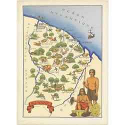
Guyane.
Very decorative, informative map of French Guyne. The map is filled with buildings, animals, figures and two locals in their typical dress.In lower left corner "Impr...
Date: France, 1943
Selling price: ????
Please login to see price!
Sold in 2014
Buenos Aires Capital de La Republica Argentina. Una Nacion Socialmente Justa Economicamente Libre. . .
A beautiful pictorial town plan of the Argentinian Capital Buenos Aires, as published in 1950. The downtown area of side streets and attractive wide avenues are covered w...
Date: Buenos Aires, ca 1950
Selling price: ????
Please login to see price!
Sold in 2019

Air France Amérique du Sud.
Very decorative lithographed advertising poster of South America, for Air France, by Lucien Boucher. The poster has always occupied a special place in Air France's commun...
Date: Imprimerie Perceval, Paris, 1950
Selling price: ????
Please login to see price!
Sold in 2020
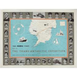
The Times Map Of The Trans-Antarctic Expedition Antarctica South Pole Vivian Fuchs Edmund Hillary.
Original vintage advertising poster - The Times Map of the Trans-Antarctic Expedition 1957-1958 Feature articles by Dr Vivian Fuchs and Sir Edmund Hillary on the Trans-An...
Date: England, 1960
Selling price: ????
Please login to see price!
Sold in 2023
