Sign In or Sign Up
Subscribe to be notified if similar examples become available.
1710 SENEX, J. - North America corrected from the observations communicated to the Royal Society of London, and the Royal Academy at Paris...
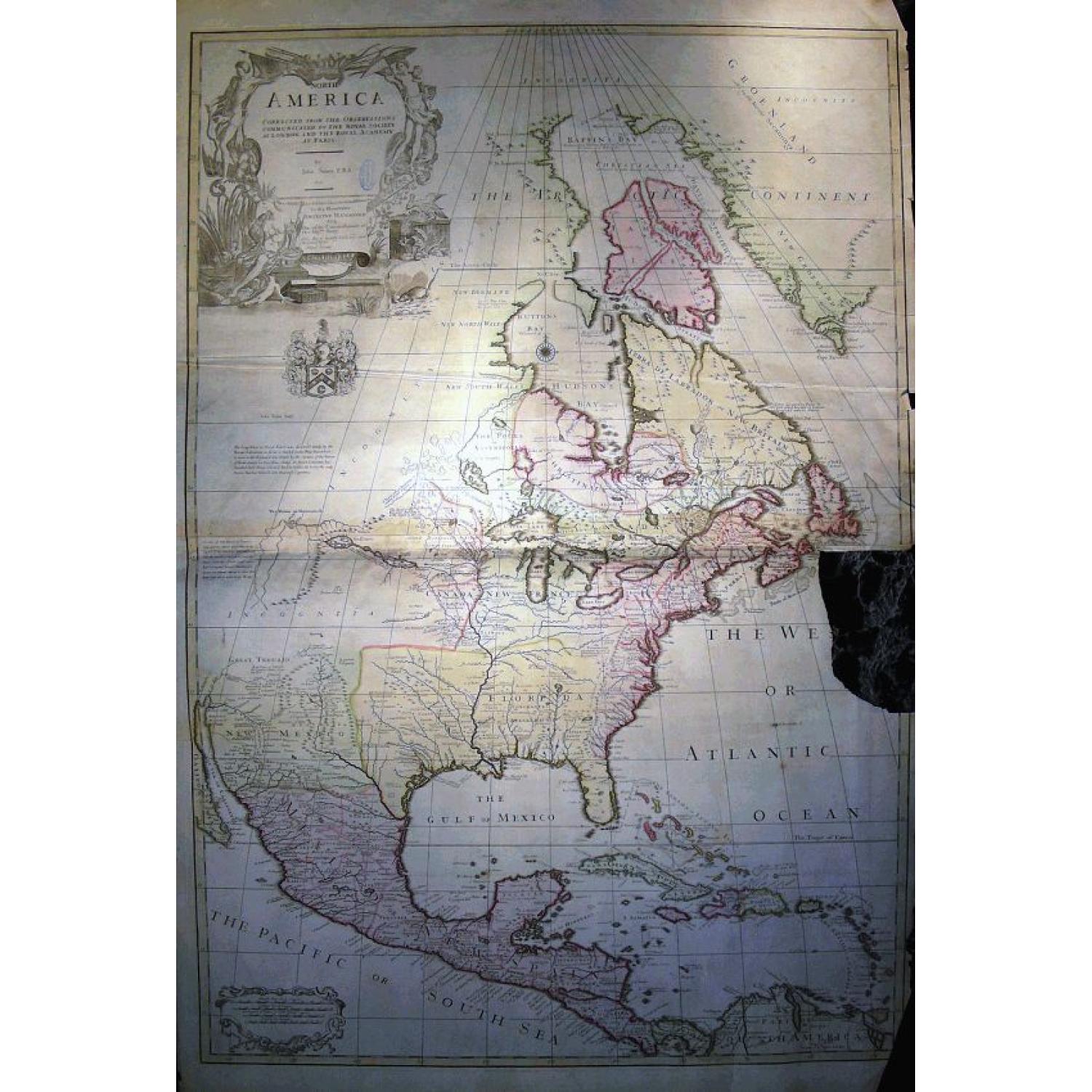
North America corrected from the observations communicated to the Royal Society of London, and the Royal Academy at Paris...
| Maker: | SENEX, J. | |
| Date: | London, c 1710 | |
| Colored: | In original colors. | |
| Size: | 965 x 650 mm / 38 x 25.6 inches | |
| Condition: | Good impression printed on heavy quality paper, with nice original coloring. Torn at right side of map with loss (approx. 15 x 10 cm) mostly to sea area off the coast of Newfoundland. Small library stamp in cartouche. Map with some folds, soiling and toni | |
Selling price: $ Please login to see price!
Sold in 2008
Missed this item !
Add your name to our mailing list and be the first to get notified about our newly added listings.
.
You can choose from more than 30,000 items from our BuyNow Catalog or Archive.
It's free, and you can delete items anytime.
 Add/Remove this item to MyCollection+




Description
Monumental and important large wall map of the Eastern part of North America with the United States, Central America, and the West Indies. Centered on the great lakes.
1st published by John Senex in London in 1710, here probably a later state dedicated to Anthony Hammond.
One of the earliest large-scale English maps of the continent. It represents a British attempt to consolidate new information about the region and borrows data from such recently published sources as Delisle's landmark Carte du Mexique et de la Floride, especially for the lower portion of the map. To this information Senex contributed a fine depiction of the Great Lakes region and the most accurate definition of the lower Mississippi River and its delta by an English cartographer of the period. He also extended the map's coverage to the far reaches of Canada's Northwest Territories and the Terra Incognita above Baffin's Bay. Present-day Oklahoma and Texas are part of 'La Floride,' considered at the time to be a possession of the French. The Red River and the Indian villages of East Texas are portrayed accurately, but Senex, following Delisle, incorrectly placed many Texas rivers, in addition to depicting some strange and unrecognizable names. An exceptional product of its era, the map has a spare, clean, carto-scientific style indicative of that for which Senex was known.
SCARCE & IMPORTANT MAP!
Reference: Stevens&Tree 61a; Lowery 273; Wagner 495; Shirley, BL Atlases SEN-1c
John Senex (1678-
John Senex was a prominent mapmaker, engraver, globemaker and publisher who practiced his trade in early eighteenth-century London. He began his career in 1695 as an apprentice to Robert Clavell of the Stationers’ Company, where he stayed until 1702. His early work primarily consisted of engraving plates for almanacs and scientific books, including Sir William Browne’s Account of Microscopes and Telescopes.In 1706, he turned his talents to cartography and began engraving and selling maps, globes, and astronomical charts. In 1710, he obtained professional premises on Fleet Street in London, and Senex frequently engraved his maps with a description of his shop’s location. As such, many of the maps in this collection have a variation of the inscription, “Engraved by Iohn Senex and sold by him at the Globe against St. Dunstan's Church, Fleet Street, London”.
Between 1710 and his death in 1740, Senex rose to prominence with the publication of his updated version of Ogilby’s Britannia. Senex’s version was in miniature (‘improved, very much corrected, and made portable’) and included updated road maps of England and Wales. As appointed geographer to Queen Anne, Senex frequently published maps and astronomical charts with preeminent eighteenth-century scientists, including astronomer Sir Edmund Halley. Together they published several maps outlining the predicted path of Halley’s namesake comet, as well as star charts and astronomical globes. Their collaboration also included a contentious version of a star catalog that included astronomical data Halley obtained unethically from Astronomer Royal John Flamsteed. This led Flamsteed to purchase and subsequently destroy 300 of the 400 printed charts. Halley nominated Senex for fellowship to the Royal Society of London, which was granted in July of 1728. Senex was also highly respected for producing terrestrial and celestial globes, available in sizes ranging from three to twenty-eight inches.
Following Senex’s death, his wife Mary continued operating the publishing business on Fleet Street until her retirement in 1755. Mary published a broadsheet advertising the continued sale of Senex’s work after his death, which provides descriptions of available globes, and a list of the most popular maps along with prices.
FAQ - Guarantee - Shipping
This item is available for immediate purchase when a "Add to Cart" or "Inquire Now" button is shown.
Items are sold in the EU margin scheme
Payments are accepted in Euros or US Dollars.
Authenticity Guarantee
 We provide professional descriptions, condition report (based on 45 years experience in the map business)
Paulus Swaen warrants the authenticity of our items and a certificate of authenticity is provided for each acquired lot.
Condition and Coloring
We indicate the condition of each item and use our unique HiBCoR grading system in which four key items determine a map's value: Historical Importance, Beauty, Condition/Coloring and Rarity.
Color Key
We offer many maps in their original black and white condition. We do not systematically color-up maps to make them more sellable to the general public or buyer.
Copper engraved or wood block maps are always hand colored. Maps were initially colored for aesthetic reasons and to improve readability. Nowadays, it is becoming a challenge to find maps in their original colors and are therefor more valuable.
We use the following color keys in our catalog:
Original colors; mean that the colors have been applied around the time the map was issued.
Original o/l colors; means the map has only the borders colored at the time of publication.
Colored; If the colors are applied recently or at the end of the 20th century.
Read more about coloring of maps [+]
Shipping fee
A flat shipping fee of $ 30 is added to each shipment by DHL within Europe and North America. This covers : International Priority shipping, Packing and Insurance (up to the invoice amount).
Shipments to Asia are $ 40 and rest of the world $50
We charge only one shipping fee when you have been successful on multiple items or when you want to combine gallery and auction purchases.
Read more about invoicing and shipping
FAQ
Please have a look for more information about buying in the BuyNow gallery
Many answers are likely to find in the general help section.
MyCollection+

With My Collection+ you can collect all your favorite items in one place. It is free, and anyone can create his or her virtual collection.
Unless you are logged in, the item is only saved for this session. You have to be registered and logged-in if you want to save this item permanently to My Collection+. Read More[+]
Register here, it is free and you do not need a credit card.
Add this item to My Collection+ or click the following link to see My Collection+.
|
Digital Image Download Paulus Swaen maintains an archive of most of our high-resolution rare maps, prints, posters and medieval manuscript scans. We make them freely available for download and study. Read more about free image download |
Click the image for a free small image download. |

YOUR RIGHT TO CANCEL THE PURCHASE OF A LOT
In accordance with the EU Consumer Rights Directive and habitually reside in the European Union you have the right to cancel the contract for the purchase of a lot, without giving any reason.
The cancellation period will expire 14 calendar days from the day after the date on which you or a third party (other than the carrier and indicated by you) acquires, physical possession of the lot. To exercise the right to cancel you must inform Paulus Swaen Inc, of your decision to cancel this contract by a clear statement (e.g. a letter sent by post, or e-mail.
To meet the cancellation deadline, it is sufficient for you to send your communication concerning your exercise of the right to cancel before the cancellation period has expired.
