Browse Listings in America
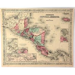
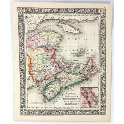
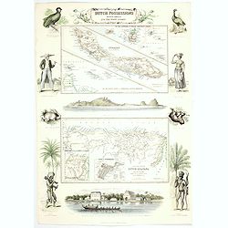
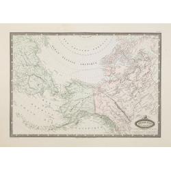
Johnson's Central America
A very pleasing map of Central America and Jamaica. Original hand colors surrounded by the usual fretwork border. From "Johnson's Atlas" by Johnson & Ward.
Date: New York, 1856
Selling price: ????
Please login to see price!
Sold in 2017
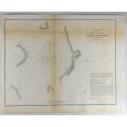
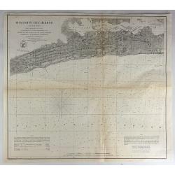
Reconnaissance of Steilacoom Harbor, Washington Ter.
Original lithograph of the U.S. Coast Survey map of Steilacoom Harbor, Washington Territory from 1856. It is from a trigonometrical survey under the direction of A.D. B...
Date: Washington, 1856
Selling price: ????
Please login to see price!
Sold in 2018
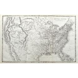
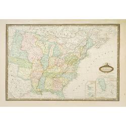
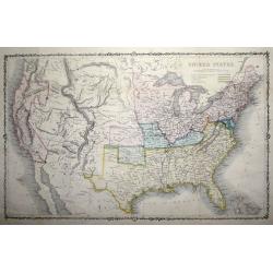
A New Map of the United States of America By J.H. Young.
Uncommon 1856 edition of Charles Desilver's map of the United States, illustrating the evolving American West. Includes explanation and notes. Shows capital of states and...
Date: Philadelphia, 1856
Selling price: ????
Please login to see price!
Sold in 2018
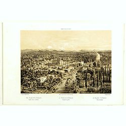
The vilage of Ixtacalco. Taken from a balloon. El pueblo de Ixtacalco Tomado en globo. Le village d'Ixtacalco Pris en ballon.
The village of Ixtacalco, taken from a balloon. The plate has caption title in English, Spanish and French, from the rare publication MEXICO Y SUS ALREDEDORES, the most e...
Date: Mexico, Establecimiento Litografico de Decaen, 1855-1856
Selling price: ????
Please login to see price!
Sold in 2018
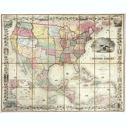
United States of America the British Provinces, Mexico...
Large engraved folding map surrounded by a decorative grapevine border interspersed with twelve insets and a large American eagle in front of a port. The map's coverage ...
Date: New York, 1856
Selling price: ????
Please login to see price!
Sold in 2019
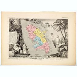
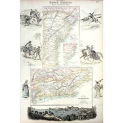
Colonies Francaises - Martinique Amerique du Sud.
A beautiful map from one of the finest decorative atlases of the nineteenth century. The map is surrounded with engravings depicting the countryside with trade goods incl...
Date: Paris, 1856
Selling price: ????
Please login to see price!
Sold in 2020
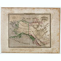
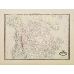
Carta dell' America settentrionale.
Uncommon Italian map with the Republic of Texas, the United States extending into present-day Canada, Russia in control of Alaska. Map is in outlined color.Many Indian na...
Date: Turin 1857
Selling price: ????
Please login to see price!
Sold
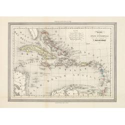
Antille od Indie Occidentali per il geografo T.Duvoteney.
Uncommon Italian map of Caribbean. Map is in outlined color.Many Indian names and settlements.From Geografia Storica and published by Fratelli Doyen in Turin.
Date: Turin, 1857
Selling price: ????
Please login to see price!
Sold in 2023
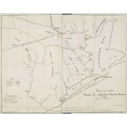
Tracé d'une partie du Chemin de Fer de Galveston à Houston et Henderson. Texas Etats Unis D'Amerique.
Hand colored map of the area between Galveston, Harrisburg, Richmond and Houston, showing "Galveston, Houston & Henderson railroad", also "Buffalo Bayo...
Date: Paris, ca. 1857
Selling price: ????
Please login to see price!
Sold in 2010
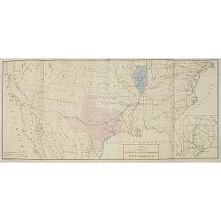
Carte du Chemin de Fer de Galveston Houston & Henderson. Texas Etats Unis D'Amerique.
Hand colored map of the United States showing the "Galveston, Houston & Henderson" railroad system. The state of Texas is colored in pink and Illinois in bl...
Date: Paris, Imp. Kaeppelin, 17 Quai Voltaire, ca 1857
Selling price: ????
Please login to see price!
Sold in 2010
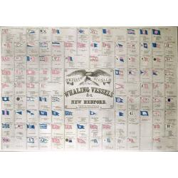
Private Signals of the Whaling Vessels Belonging to the Port of New Bedford.
Smaller (and maybe later?) edition of this important and rare publication, showing numerous flags of shipping companies, with the ships names. Lithograph with color, pub...
Date: New Bedford, c.1857
Selling price: ????
Please login to see price!
Sold in 2011
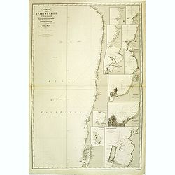
Carte des côtes du Chili et de la Bolivie dressée d'après les Traveux du Cap.e Fitz-Roy par Robiquet . . .
Large chart of the coast of Chili, with 11 detailed insets. Engraved by Louis A. Sengteller.
Date: Paris, 1857
Selling price: ????
Please login to see price!
Sold in 2012
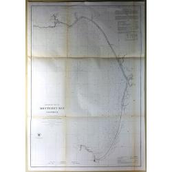
Preliminary Chart of Monterey Bay California.
Antique Electrotype Map, published in 1857 in Washington for the "Report of the Superintendent of the U.S. Coast Survey..." Published under the supervision and ...
Date: Washington, 1857
Selling price: ????
Please login to see price!
Sold in 2016
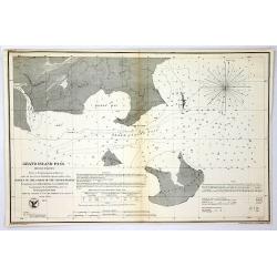
Grand Island Pass, Mississippi.
Antique Electrotype Map Published 1843-65, Washington for "Report of the Superintendent of the U.S. Coast Survey..." Published under the supervision and directi...
Date: Wahsington, 1857
Selling price: ????
Please login to see price!
Sold in 2016
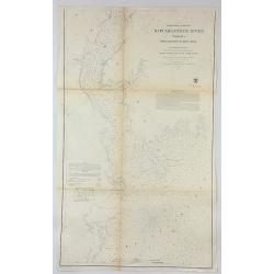
Preliminary Chart of Rappahannock River Virginia From Entrance to Deep Creek.
An informative large U.S. Coast Survey nautical chart of Virginia's Rappahannock River. It covers the course of the Rappahannock River from the Chesapeake Bay to Deep Cre...
Date: Washington, 1857
Selling price: ????
Please login to see price!
Sold in 2018
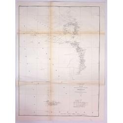
Sketch K Showing the Progress of the Survey in Section No. XI (Upper Sheet) from Tillamook Bay to the Boundary.
A fine 1857 US Costal Survey map, or triangulation chart, of Washington State, from Tillamook Head to Vancouver Island, including Juan De Fuca Strait, the Puget Sound, Ol...
Date: Washington, 1857
Selling price: ????
Please login to see price!
Sold in 2017
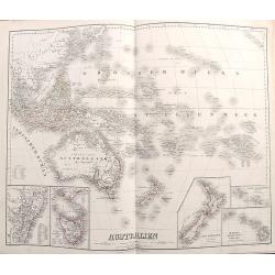
Australien.
Richly detailed map of Australia and the Pacific. Extends from Indonesia until California and names hundreds of islands in the Great Ocean. Australia is called Austral As...
Date: Weimar, 1857
Selling price: ????
Please login to see price!
Sold in 2017
Mississippi Harbor.
Original lithograph of the U.S. Coast Survey map of Mississippi Harbor, Mississippi from 1857. It is from a trigonometrical survey under the direction of A.D. Bache Supe...
Date: Washington, 1857
Selling price: ????
Please login to see price!
Sold in 2018
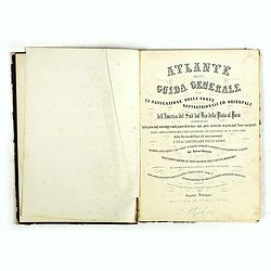
Atlante della Guida generale per la navigazione delle coste settentrionali ed orientali dell' America de Sud dal Rio della Plata al Parà...
A good example of the first edition, extra illustrated. The Atlante is a rare and important collection of lithographed charts, plans, and city views of the Atlantic coast...
Date: Naples, Caro Batelli, 1857
Selling price: ????
Please login to see price!
Sold in 2018
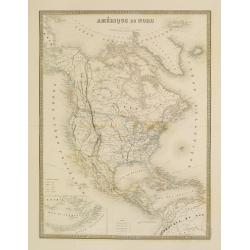
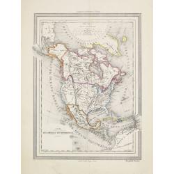
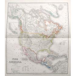
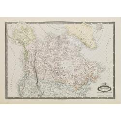
L'Amérique du Nord.
Large map of North America with an inset of the Aleutians in the lower left corner.
Date: Paris, 1858
Selling price: ????
Please login to see price!
Sold in 2022
Map of the City & County of New York.
Detailed lithograph plan in two joined parts. The upper map details lower Manhattan up to 39th Street, and the lower map continuing the chart up to King's Bridge. There a...
Date: New York, 1858
Selling price: ????
Please login to see price!
Sold in 2017
Map of lakes Huron, superior & Michigan, on a smaller scale. / Map of the Buffalo, Brantford & Goderich railway west Canada with its connections
Two maps on one sheets. First map of "Map of lakes Huron, superior & Michigan, on a smaller scale." measuring 227 x 150mm. The map to the right "Map of...
Date: London, after 1858
Selling price: ????
Please login to see price!
Sold in 2020
Die Vereinigten Staaten von Nord America nebst Canada.
A fascinating map of the United States, also parts of Canada and Mexico. Names several Territories and also Indian Territory. One of the most detailed maps of its time.
Date: Weimar, 1858
Selling price: ????
Please login to see price!
Sold in 2017
America.
A large map of the Americas with remarkable detail. Includes many early Territories shortly before statehood such as Utah, Oregon, Washington, Nebraska, etc. Shows Americ...
Date: Weimar, 1858
Selling price: ????
Please login to see price!
Sold in 2017
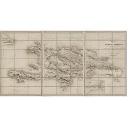
Mapa de la isla de Santo Domingo.
Impressive map of Saint Domingo. Includes indexed inset map of Santo Domingo 'Plan de la ciudad de Santo Domingo y de suyos contornos', distance tables and a coastal prof...
Date: Paris, 1858
Selling price: ????
Please login to see price!
Sold in 2017
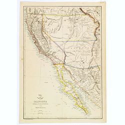
California, Utah, Lower California and New Mexico.
This is a British-produced map of the Southwest of the United States was included in the January 31, 1858 Sunday Supplement to the Weekly Dispatch newspaper. The map cove...
Date: London, 1858
Selling price: ????
Please login to see price!
Sold in 2018
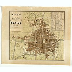
Plano General de la Ciudad de México, año de 1858.
Fine plan of Mexico city in 1858. The plate has a key (A-O, 1 - 92 and I -V) to most important squares, streets and buildings. From the rare publication MEXICO Y SUS ALRE...
Date: Mexico city, 1858
Selling price: ????
Please login to see price!
Sold in 2018
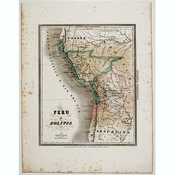
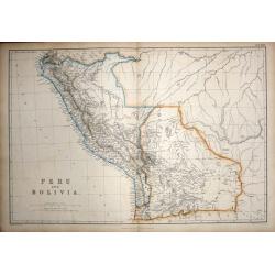
Peru e Bolivia.
Uncommon map of Peru and Bolivia prepared by Francesco Costantino Marmocchi. Above the map "Geografia Commerciale". From "Il Globo Atlante di carte Geograf...
Date: Genova, Paolo Rivara fu Giacomo, 1858
Selling price: ????
Please login to see price!
Sold in 2020
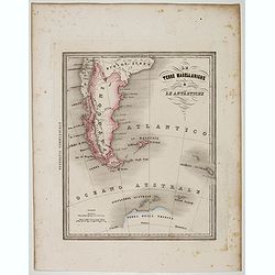
Le Terre Magellanighe e Le Antartiche.
Uncommon map of Patagonia and part of Antarctica, prepared by Francesco Costantino Marmocchi. Above the map "Geografia Commerciale". From "Il Globo Atlante...
Date: Genova, Paolo Rivara fu Giacomo, 1858
Selling price: ????
Please login to see price!
Sold in 2022
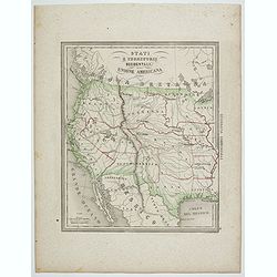
Stati e territorii Occidentali della Unione Americana.
Rare map of the Transmississippi West, with an oversized California, Oregon, Nebraska, Kansas, New Mexico and Utah and a totally eclipsing Washington, Idaho, North & ...
Date: Genova, Paolo Rivara fu Giacomo, 1858
Selling price: ????
Please login to see price!
Sold in 2020
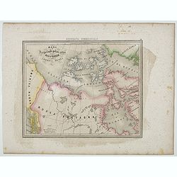
Mari e Arcipelaghi Polari Artici dalla Baia d'Hudson all' America Russa.
Uncommon map of Canada prepared by Francesco Costantino Marmocchi. Above the map "Geografia Commerciale". From "Il Globo Atlante di carte Geografiche compi...
Date: Genova, Paolo Rivara fu Giacomo, 1858
Selling price: ????
Please login to see price!
Sold in 2020
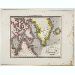
Islanda Groenlandia e Mediterraneo Artico.
Uncommon map of Canada, Greenland and Iceland prepared by Francesco Costantino Marmocchi. Above the map "Geografia Commerciale". From "Il Globo Atlante di ...
Date: Genova, Paolo Rivara fu Giacomo, 1858
Selling price: ????
Please login to see price!
Sold in 2021
America Russa.
Uncommon map of Alaska prepared by Francesco Costantino Marmocchi. Above the map "Geografia Commerciale". From "Il Globo Atlante di carte Geografiche compi...
Date: Genova, Paolo Rivara fu Giacomo, 1858
Selling price: ????
Please login to see price!
Sold in 2020
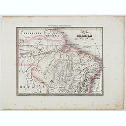
Impero del Brasile Parte Nord.
Uncommon map of Brazil northside prepared by Francesco Costantino Marmocchi. Above the map "Geografia Commerciale". From "Il Globo Atlante di carte Geograf...
Date: Genova, Paolo Rivara fu Giacomo, 1858
Selling price: ????
Please login to see price!
Sold in 2022
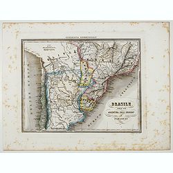
Brasile Parte Sud Argentina, Chili, Uruguay e Paraguay.
Uncommon map of Brasile Southside, Argentina, Chili, Uruguay and Paraguay. northside prepared by Francesco Costantino Marmocchi. Above the map "Geografia Commerciale...
Date: Genova, Paolo Rivara fu Giacomo, 1858
Selling price: ????
Please login to see price!
Sold in 2022
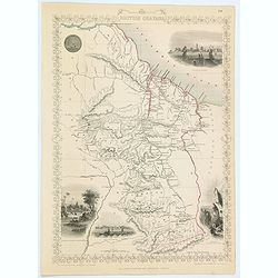
British Guayana.
A decorative steel engraved map of British Guyana. The last Tallis map of the region, published circa 1858 by The London Printing and Publishing Company (the partnership ...
Date: London, 1858
Selling price: ????
Please login to see price!
Sold in 2020
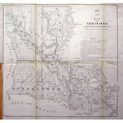
Map of Louisiana Representing the Several Land Districts.
A very uncommon lithograph map of Louisiana. The work is a detailed survey of the State's various land divisions. A 12 point reference table provides letter coding and ic...
Date: Donoldsonville, 1859
Selling price: ????
Please login to see price!
Sold in 2013
Nord America mit Westindien.
A great map with a lot of interesting details: Nebraska extends to Canada and the Rocky Mountains. Kansas includes most of today's Colorado. Large Utah and New Mexico Ter...
Date: Weimar, 1859
Selling price: ????
Please login to see price!
Sold in 2017
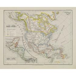
Verein-Staaten von Nord-America, Mexico, Yucatan u. A.
An early edition of this interesting map. Very detailed and with very interesting geography, such as a large New Mexico but no Arizona. Also a large Utah territory, and a...
Date: Gotha, 1859
Selling price: ????
Please login to see price!
Sold in 2018
![North America [Sheet XV] Utah, New Mexico, Texas, California &c. . .](/uploads/cache/42397-250x250.jpg)
North America [Sheet XV] Utah, New Mexico, Texas, California &c. . .
A detailed steel engraved map of the American S.W. showing the states of California, New Mexico, Texas, Indian Territory (Oklahoma), Utah, Kansas and parts of Missouri, N...
Date: London, 1859
Selling price: ????
Please login to see price!
Sold in 2018

Chicago in 1820.
A fascinating steel engraving of early frontier Chicago, adapted from a sketch done by H. R. Schoolcroft. The view depicts indigenous Americans canooing on Lake Michigan ...
Date: Washington DC, ca 1860
Selling price: ????
Please login to see price!
Sold
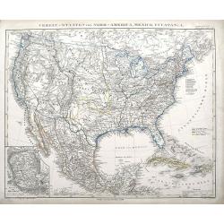
Mexique Antilles, États-Unis..
Very detailed map of the United states. Engraved by Ch.Dyonnet, prepared by A.H.Dufour for his "Atlas Universele".
Date: Paris 1860
Selling price: ????
Please login to see price!
Sold
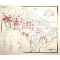
Plan von Washington 1845
A finely engraved plan of pre Civil War Washington D.C., as it was in 1845. There is an inset plan of the Capitol building, which was not yet built at the time. In additi...
Date: Heidelberg, 1860
Selling price: ????
Please login to see price!
Sold
The City of Chicago, Illinois, Where the Republican Convention will Meet on May 16, 1860.
A handsome woodcut pre-great-fire view of Chicago. The work depicts the city as seen in the late 1850s and centers on the Chicago River.Numerous sailing and steam vessels...
Date: New York, 1860
Selling price: ????
Please login to see price!
Sold
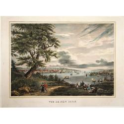
Vue de New York.
A view of New York over the bay with ships and boats as well as some people in the foreground. Probably after D. Fabronius and published by P. Cremetti in Brussels.
Date: Bruxelles 1860
Selling price: ????
Please login to see price!
Sold
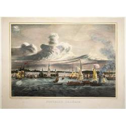
Nouvelle Orléans.
A view of a part of the town of New Orleans, seen from the river with ships and boats in the foreground. After D. Fabronius (in the stone signed) and published by P. Crem...
Date: Bruxelles 1860
Selling price: ????
Please login to see price!
Sold
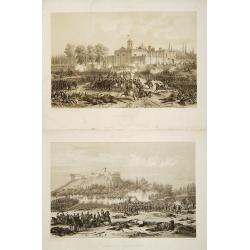
2 historial plates dealing with US/Mexican War (1846-1848).
2 plates sold by the famous Mexican publisher Julio Michaud's shop (estampería) who collaborated with a man known today only as Thomas. He published Álbum Pintoresco de...
Date: Mexico/ Paris c.1860
Selling price: ????
Please login to see price!
Sold
Messico Nuova Spagna.
Uncommon map of Mexico and Baya California. Prepared by T.Duvotenay and published in an Italian version by Calcolitografia Fratelli Doyen, Torino. All nales translated to...
Date: Milan c.1860
Selling price: ????
Please login to see price!
Sold
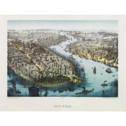
Vue de New York.
This scene includes careful renderings of the buildings in lower Manhattan and Brooklyn. Castle Garden, which was then an entertainment hall, is shown offshore of Battery...
Date: Paris 1860
Selling price: ????
Please login to see price!
Sold
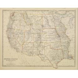
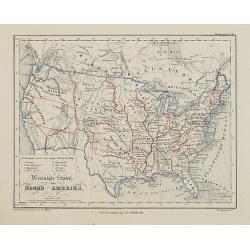
United States of North America. Western States.
Detailed map of western part of North America by Keith Johnston, a well-known publisher of maps who continually updated their regional maps. From his Royal Atlas . With g...
Date: Edinburg 1860
Selling price: ????
Please login to see price!
Sold
Amérique Boréale, Nouv.le Bretagne & Canada.
Very detailed map from Atlas Sphérodïdal & Universel de géographie , Prepared by F.A.Garnier and edited by Jules Renouard, rue de Tournon, Paris.Uncommon map with ...
Date: Paris 1860
Selling price: ????
Please login to see price!
Sold
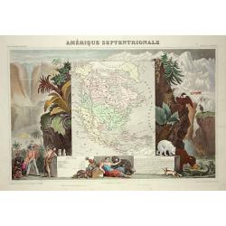
Amerique Septentrionale
Lovely map with an INDEPENDENT TEXAS. The United States extending into present day Canada, Russia in control of Alaska and Mexico's northern border according to the Treat...
Date: Paris 1860
Selling price: ????
Please login to see price!
Sold

Isba, Maison des colonies de l'Amérique Russe.
Early print of a colonial house in Alaska. Engraved by Ch.Ransonette and published by Arthus Bertrand. From: Voyage de M.D. de Mofras .Duflot de Mofras, an attaché of th...
Date: Paris, 1860
Selling price: ????
Please login to see price!
Sold in 2012
Noord-Amerika.
Uncommon map of North America including Canada and Mexico. Inset map of Central America. Lithography by J.H. van Weijer, published in Atlas der geheele Aarde [?] in 24 ka...
Date: Groningen, ca. 1860
Selling price: ????
Please login to see price!
Sold in 2008
Vereenigde Staten van Noord-Amerika.
Uncommon map of the United States of America. Lithography by J.H. van Weijer, published in Atlas der geheele Aarde [?] in 24 kaarten.
Date: Groningen, ca. 1860
Selling price: ????
Please login to see price!
Sold in 2015
Zuid Amerika.
Uncommon map of South America. Lithography by J.H. van Weijer, published in Atlas der geheele Aarde [?] in 24 kaarten. With colored key to English, French, Dutch, Spanish...
Date: Groningen, ca. 1860
Selling price: ????
Please login to see price!
Sold in 2012

2 Papier peints: 'West Point in New York'' and ''Boston Harbor''.
Two panels from one of Zuber's grandest panoramic wallpapers (papier peint) is a set of American landscapes, "Les Vues de L'Amérique du Nord" (Views of North A...
Date: Rixham, ca. 1852 - 1860
Selling price: ????
Please login to see price!
Sold in 2011
Noord Amerika naar de bestebronnen vervaardigd onder toezigt van J. van Wijk Roelandsz. . .
A mid-nineteenth century map of America by the Dutch mapmakers and publishers Roelandsz and Zoon. Showing Alaska still belong to Russia.Engraved by J. Jaeger.
Date: Groningen, c. 1860
Selling price: ????
Please login to see price!
Sold in 2012
Dutch Possessions in South America and the West Indies.
Large sheet with two maps showing Dutch possessions in the Caribbean and South America. The top map shows Curaçao in large scale, also Saba, and St. Martin. The bottom m...
Date: London, c1860
Selling price: ????
Please login to see price!
Sold in 2015
Peru and Bolivia.
Published by Blackie & Son Glasgow Edinburgh & London 1860. This highly detailed map of the area comes from "The Imperial Atlas of Modern Geography". Po...
Date: Glasgow Edinburgh & London, 1860
Selling price: ????
Please login to see price!
Sold in 2015
County Map of Nova Scotia, New Brunswick, Cape Breton Island and Prince Edward Island
A pleasing map of the Canadian Maritime Provinces, with attention to both political and geographical elements. Complete with inset of the city of Halifax. Map is surround...
Date: Philadelphia, 1860
Selling price: ????
Please login to see price!
Sold in 2016
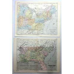
Etats-Unis, Region du Sud & Etats-Unis, Region du Nord (2 Maps).
A pair of chromo-lithograph maps featuring north and south United States. They are by A.H. Dufour and from "ATLAS POPULAIRE" published by Gustave Barba of Paris...
Date: Paris , 1860
Selling price: ????
Please login to see price!
Sold in 2017
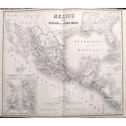
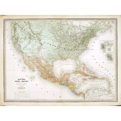
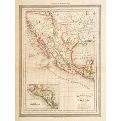
Mexico und die Republiken von Central-America.
Large and detailed map of Central America, Mexico and the contiguous parts of California, New Mexico, Texas and the very southern US. Two inset maps of the Tehuantepec an...
Date: Weimar, ca. 1860
Selling price: ????
Please login to see price!
Sold in 2017
Map of the Great Salt Lake; The Great Salt Lake (Mormon) City;
Two important maps on one sheet showing Salt Lake City in Utah, and its surroundings. Both maps are very detailed, with many place names of rivers, settlements, springs, ...
Date: London, ca. 1860
Selling price: ????
Please login to see price!
Sold in 2018
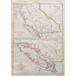
British Columbia (New Caledonia); Vancouver Island;
Two maps on one sheet. Both maps are very detailed, with many place names of rivers, islands, towns, forts, etc. The map of Vancouver shows the island in considerable sca...
Date: London, ca. 1860
Selling price: ????
Please login to see price!
Sold in 2018
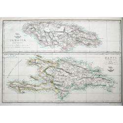
Jamaica; Hayti.
Two maps on one sheet, both very detailed with many place names, roads, hills, etc.The Weekly Dispatch newspaper was published in London between the years 1856 and 1862,...
Date: London, ca 1860
Selling price: ????
Please login to see price!
Sold in 2018
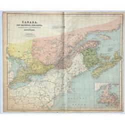
Canada, New Brunswick, Nova Scotia, Cape Breton Island, Prince Edward Island and Newfoundland.
A fine, large, chromolithograph map of the Maritime provinces of Canada. Published by George Philip & Son of London in 1860 – 7 years before Canada was formed. New...
Date: London, 1860
Selling price: ????
Please login to see price!
Sold in 2019
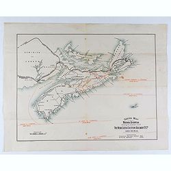
Sketch map of Nova Scotia showing the proposed line of the Nova Scotia eastern railway . . .
Lithograph map of Nova Scotia showing the proposed line of the Nova Scotia Eastern Railway.
Date: London, ca. 1860
Selling price: ????
Please login to see price!
Sold in 2021
United States.
An unusual map of the United States. With excellent detail throughout. With "Indian Territory" north of Texas. Canada is named British America. Shows the Missou...
Date: ca. 1860
Selling price: ????
Please login to see price!
Sold in 2020
Dutch Possessions in South America and the West Indies.
Two maps are shown: one of the island of Curaçao with insets of the Leeward and the Lesser Antilles and a map of the northern part of Dutch Guyana with insets of a plan ...
Date: London, 1860
Selling price: ????
Please login to see price!
Sold in 2020
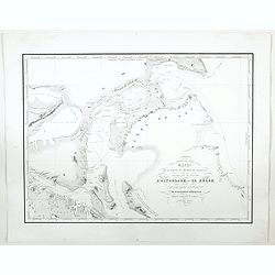
Carte de la partie du Detroit de Magellan reconnue par les Corvettes L'Astrolabe et La Zelee. . .
A detailed map of the Straits of Magellan, prepared by Vincendon Dumoulin after a visit of the ships L'Astrolabe and La Zelee in the year 1841. From Voyage au Pole Sud et...
Date: Paris, 1860
Selling price: ????
Please login to see price!
Sold in 2023
Amerique du Sud Spheroidale.
"Very detailed map from ""Atlas Sphérodïdal & Universel de géographie"", Prepared by F.A.Garnier and edited by Jules Renouard, rue de Tour...
Date: Paris, 1861
Selling price: ????
Please login to see price!
Sold in 2021
Amérique Russe et partie de regions polaires boeales.
Very detailed map from Atlas Sphéroïdal & Universel de géographie , Prepared by F.A.Garnier and edited by Jules Renouard, rue de Tournon, Paris. Uncommon with deco...
Date: Paris, 1861
Selling price: ????
Please login to see price!
Sold in 2012
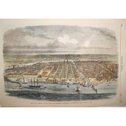
Balloon view of Washington, D. C.
An impressive wood cut balloon view of Washington, D. C. at the start of the American Civil War. The Capitol is seen in the foreground, with its dome under construction. ...
Date: New York, 1861
Selling price: ????
Please login to see price!
Sold

Abraham Lincoln. Président des Ëtats-Unis.
Very fine steel engraving of Abraham Lincoln. Engraved in steel by Carl Mayer.
Date: c. 1861
Selling price: ????
Please login to see price!
Sold
États-Unis de L'Amérique du Nord..
Very detailed map from "Atlas Spherodidal & Universel de geographie", Prepared by F.A.Garnier and edited by Jules Renouard, rue de Tournon, Paris. Uncommon ...
Date: Paris, 1861
Selling price: ????
Please login to see price!
Sold
Amérique Boréale, Nouv.le-Bretagne & Canada.
Very detailed map from Atlas Sphérodoïdal & Universel de géographie , Prepared by F.A.Garnier and edited by Jules Renouard, rue de Tournon, Paris. Uncommon map wit...
Date: Paris, 1861
Selling price: ????
Please login to see price!
Sold in 2016
EAST COAST OF SOUTH AMERICA; BRAZIL, MIDDLE PROVINCES
Excellent lithograph published by Fullarton. Shows two maps of Brazil: "East Coast of Brazil" & "Province of Rio de Janeiro" both by H.Mahlmann a...
Date: London, Edinburgh, Dublin, c.1861
Selling price: ????
Please login to see price!
Sold
United States.
An uncommon pre-Civil War issue that was published by the London Printing and Publishing Company. Circa 1861.A highly detailed map which covers the entire country, issued...
Date: London 1861
Selling price: ????
Please login to see price!
Sold in 2015
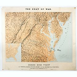
The Seat of War. Birds Eye View of Virginia, Maryland, Delaware and the District of Columbia.
A large and striking example of the seat of the civil war in the mid-Atlantic states in 1861. Extending from the southern reaches of New Jersey and Pennsylvania to northe...
Date: New York, London, Paris, 1861
Selling price: ????
Please login to see price!
Sold in 2020