Browse Listings in America > Central America
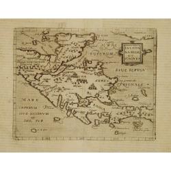
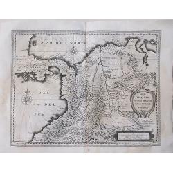
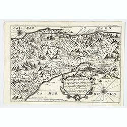
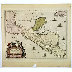
Iucatana Regio et Fondura.
Very rare sixteenth century map of Yucatan and Honduras.Published in the German edition of José de Acosta's De Natura Nova Orbis, first published in Salamanca, 1588. Acos...
Date: Cologne 1598
Selling price: ????
Please login to see price!
Sold
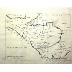
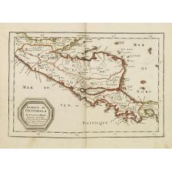
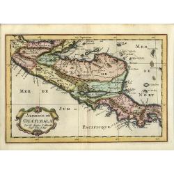
Descripcíon del Audiencía de Guatimala
Rare Spanish map with some place names along the coast, but scant internal detail, reflecting the official policy of protecting Spanish knowledge of the New World. This m...
Date: Amsterdam, 1622
Selling price: ????
Please login to see price!
Sold in 2011
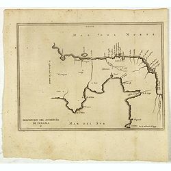
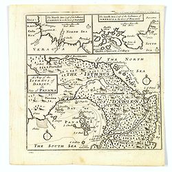
Descripcion del audiencia de Panama.
Rare early map of the Audiencia of Panama. The earliest map to include information from the previously secret manuscript maps of the Spanish cosmographer, Juan López de V...
Date: Amsterdam, 1622
Selling price: ????
Please login to see price!
Sold in 2017
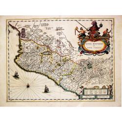
Nova Hispania et Nova Galicia.
Willem Blaeu’s beautiful map of Mexico is decorated with a very large title-cartouche with the coat-of-arms of the king of Spain, another cartouche and two ships and a co...
Date: Amsterdam, ca 1630
Selling price: ????
Please login to see price!
Sold in 2020
![[Pizarro forms a pact with Almagro.]](/uploads/cache/40363-250x250.jpg)
[Pizarro forms a pact with Almagro.]
On his way back from Spain with the royal consent to conquer Peru, Pizarro forms a pact with Almagro in Panama. In order to ensure the pact was binding, they both swore a...
Date: Frankfurt, M.Merian, 1633
Selling price: ????
Please login to see price!
Sold
![[Plans in Panama for the conquest of Peru.]](/uploads/cache/40364-250x250.jpg)
[Plans in Panama for the conquest of Peru.]
Having sworn co-operation and agreement to share between them the riches they hoped to find in Peru, Francisco Pizarro, Diego de Almagro and the priest Hernando de Luque,...
Date: Frankfurt, M.Merian, 1633
Selling price: ????
Please login to see price!
Sold
![[The dogs of Vasco Nunez de Balboa attacking native Indians]](/uploads/cache/40484-250x250.jpg)
[The dogs of Vasco Nunez de Balboa attacking native Indians]
A brutal scene in which the dogs of the Spanish explorer Vasco Nunez de Balboa, ferociously attack native Indians, while the Spanish look on.In 1631 Johann Ludwig Gottfri...
Date: Frankfurt, M.Merian, 1633
Selling price: ????
Please login to see price!
Sold in 2025
![[Inca gold goes to Panama.]](/uploads/cache/40365-250x250.jpg)
[Inca gold goes to Panama.]
Much of the gold stolen from the Incas was taken to the Town of Panama, where it was transported by mules across the Isthmus to Nombre de Dios, on the Caribbean coast, to...
Date: Frankfurt, M.Merian, 1633
Selling price: ????
Please login to see price!
Sold
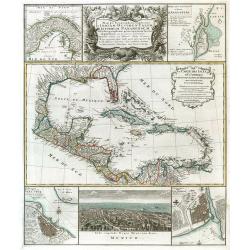
![[Lot of 7 maps and gravure] Nova Hispania et Nova Galicia. [with map of Guatamala]](/uploads/cache/IMG_2235-250x250.jpg)
[Lot of 7 maps and gravure] Nova Hispania et Nova Galicia. [with map of Guatamala]
Willem Blaeu’s beautiful map of Mexico is decorated with a very large title-cartouche with the coat-of-arms of the king of Spain, another cartouche and two ships and a co...
Date: Amsterdam, ca 1636
Selling price: ????
Please login to see price!
Sold in 2023
Terra Firma et Novum Regnum Granatense et Popayan.
A very decorative, large, early map of modern-day Panama and Colombia. With Latin text on verso.
Date: Amsterdam, 1640
Selling price: ????
Please login to see price!
Sold in 2018
![[ Lot of 3 maps] Terra Firma et Novum Regnum.](/uploads/cache/19390-(1)-250x250.jpg)
[ Lot of 3 maps] Terra Firma et Novum Regnum.
Willem Blaeu’s map of Columbia with the Isthmus of Panama. Embellished with two cartouches and two compass-roses. Willem Blaeu, the father of Johan and Cornelis Blaeu, wa...
Date: Amsterdam, 1655
Selling price: ????
Please login to see price!
Sold in 2022
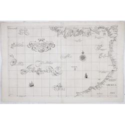
Carta particolare del'mare del Zur che comincia con il capo S. Francesco nel Peru e finisce con il capo S. Lazaro nella nuova Spagnia.
FIRST EDITION Dudley’s magnificent chart of the Pacific Coast of Central and South America, from the coast of Columbia and Ecuador in the north to the Bay of Honduras in ...
Date: Florence 1661
Selling price: ????
Please login to see price!
Sold in 2023
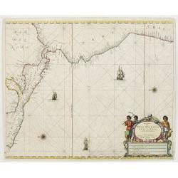
Pascaerte van Nova Hispania Chili Peru en Guatimala..
A scarce chart of southern part of Mexico, Central America, Peru and Chilli. The chart also depicts sailing ships and two compass roses.
Date: Amsterdam 1666
Selling price: ????
Please login to see price!
Sold
Audience de Guatimala. . .
A finely engraved map of Central America, from the Gulf of Panama and Y. de Perlas to the Southern part of the Yucatan, including the Gulf of Guanajos, the Gulf of Hondur...
Date: Paris, P. Marriete, 1667
Selling price: ????
Please login to see price!
Sold in 2011
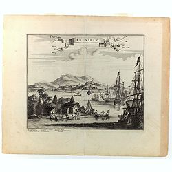
Truxillo.
A lovely copperplate view of Truxillo, situated on the northern coast of Honduras. The engraving shows a number of Spanish ships at anchor in the deep natural harbor, alo...
Date: London, ca 1671
Selling price: ????
Please login to see price!
Sold in 2022
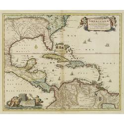
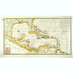
Insulae Americanae in Oceano Septentrionali cum Terris adiacentibus
A fine example of John Ogilby's map of the West Indies, based on Hessel Gerritaz’ chart of 1631 and Blaeu's map of 1635, and Janssons map of 1636. Florida is depicted in...
Date: London, 1671
Selling price: ????
Please login to see price!
Sold in 2023
Insulae Americanae in Oceano ...
A beautiful map that includes the American Southeast, part of Mexico, Central America, and the northern part of South America.
Date: Amsterdam, 1680
Selling price: ????
Please login to see price!
Sold in 2014
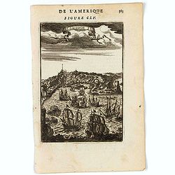
St. Salvador.
A charming view of São Salvador in Brazil, founded by the Portuguese in 1549 as the first capital of Brazil.Title in a curtain draped at the top. French text on verso.Fro...
Date: Paris, 1683
Selling price: ????
Please login to see price!
Sold in 2022
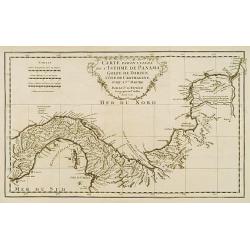
Carte de l'Isthme de Panama. . .
This very attractive map of the Isthmus of Panama was engraved for an early French edition of Alexandre Olivier Exquemelin's History of the Bucaniers of America, an inter...
Date: [Paris], 1686
Selling price: ????
Please login to see price!
Sold in 2019
Audience de Guatimala
Nice map that illustrates the region from the Yucatan to the Gulf of Panama. It is nicely detailed, although much of the topography is still incorrect. Lago de Nicaragua ...
Date: Amsterdam, 1700
Selling price: ????
Please login to see price!
Sold in 2008
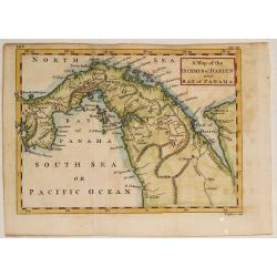
A Map of the Isthmus of Darien, & Bay of Panama.
A map of the Isthmus of Darien and Bay of Panama, with the twin insets of the North Sea Coast & the South Sea Coasts at the top. From A New Voyage around the World', ...
Date: London, ca 1700
Selling price: ????
Please login to see price!
Sold in 2019
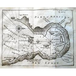
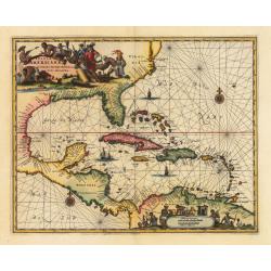
UNTITLED (Gulf of Nicoya)
Scarce chart of the Gulf of Nicoya (Costa Rica), from the account of William Dampier: "A voyage round the world..." The map is probably done by Moll. It shows ...
Date: London, ca. 1704
Selling price: ????
Please login to see price!
Sold in 2013
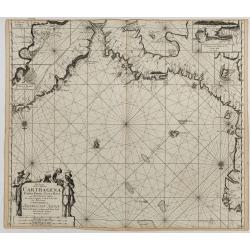
Pas-kaart van de Zee Kusten van Carthagena Tierra Firma, Costa Rica, ende Honduras…
This nautical chart shows the Caribbean coast, with Panama, Northern Colombia, Costa Rica, and Cartagena. Includes four insets: Port of Carthagena; S. Barnardo Islands; ...
Date: Amsterdam, J. van Keulen, 1697-1709
Selling price: ????
Please login to see price!
Sold in 2023
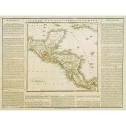
Yucatan conventus. . .Guatimala conventus. . .
A very handsome looking map, first published in 1662 by Blaeu, this later edition bears the imprint of Pierre Mortier. The map encompasses the area from Mexico City in th...
Date: Amsterdam, ca 1720
Selling price: ????
Please login to see price!
Sold in 2018
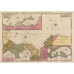
Le Golfe de Panama &cc.Cartagene,..
An impressive large sheet chart of Panama and part of the Colombia coast up to Santa Nevada de Santa Marta. In top left corner, detailed inset map (190x460mm) of Sambalas...
Date: Amsterdam 1720
Selling price: ????
Please login to see price!
Sold
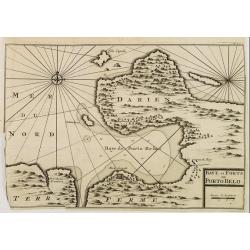
BAYE et FORTS de PORTO BELO.
Decorative map of the Portobelo Bay, in the region of Darien, Panama.From Voyages de François Coreal aux Indes Occidentales, Contenant ce qu'il y a vû de plus remarquable...
Date: Amsterdam 1722
Selling price: ????
Please login to see price!
Sold
Mappa Geographica complectens..
Decorative map depicting the region of Central America. View of Mexico.
Date: Nuremberg, 1740
Selling price: ????
Please login to see price!
Sold in 2009
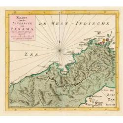
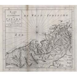
Kaart van de Landengte van Panama.
Izaak Tirion (d. 1769) Amsterdam publisher. His ' Nieuwe en beknopte handatlas' saw 6 editions between before 1740 and after 1784. Also ' Tegenwoordige staat van alle vol...
Date: Amsterdam, c. 1745
Selling price: ????
Please login to see price!
Sold in 2015
KAART van de LANDENGTE van PANAMA.
A detailed hand colored map of Panama, published in Amsterdam by Isaak Tirion. It depicts the City of Panama at the southeast, Chagres at the northwest and Porto-Bello at...
Date: Amsterdam, ca 1745
Selling price: ????
Please login to see price!
Sold in 2019
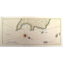
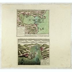
A Plan of the East End of the Island of Quibo.
A map showing the shoreline around Port de Dames indicating soft sand and mud, salt lagoons, fresh water, and fisherman's huts. Also marked are the islands of Quiveta and...
Date: London, 1748
Selling price: ????
Please login to see price!
Sold in 2015
![[Lot of 22 maps / prints] Kaart van Mexico en Nieuw Granada in de Spaansche West-Indien.](/uploads/cache/20690-(3)-250x250.jpg)
[Lot of 22 maps / prints] Kaart van Mexico en Nieuw Granada in de Spaansche West-Indien.
A detailed map showing the Caribbeans, the Gulf of Mexico with its adjacent lands and Central America.. Izaak Tirion (d. 1769) Amsterdam publisher. His ' Nieuwe en beknop...
Date: Amsterdam, c. 1750
Selling price: ????
Please login to see price!
Sold in 2022
Portus Pulchri in Isthmo Panamensi / Scenographia Portus Pulchri
The birds-eye town-plan of Portobelo with title above, and a text panel "Dieser Grund Riss von dem Hafen, der Stadt u. den Forten von Porto belo ..." Below a sc...
Date: Nuremberg, c. 1750
Selling price: ????
Please login to see price!
Sold in 2015
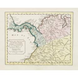
Carte particuliere de L'Isthme de Panama, Golfe de Darien, Côte de Carthagene..
This map provides an accurate picture of Panama.Jean Baptiste Bourguignon d'Anville (1697-1782) engraved his first map at age fifteen and produced many maps of high quali...
Date: Paris 1752
Selling price: ????
Please login to see price!
Sold
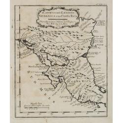
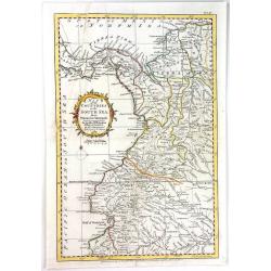
Karte von den Laendern Nicaragua und Coasta Rica. . . . N°18.
An important early map of Nicaragua and Costa Rica. In: Allgemeine Historie der Reisen zur Wasser und zu Lande: oder Sammlung aller Reisebeschreibungen.. in Englischen zu...
Date: Leipzig, 1753
Selling price: ????
Please login to see price!
Sold in 2008
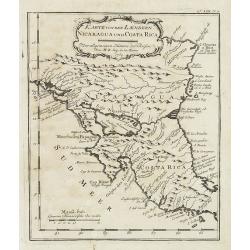
Karte von den Laendern Nicaragua und Coasta Rica. . . . N°18.
Early map of Nicaragua and Costa Rica. Published in: Allgemeine Historie der Reisen zur Wasser und zu Lande: oder Sammlung aller Reisebeschreibungen.. in Englischen zusam...
Date: Leipzig, 1753
Selling price: ????
Please login to see price!
Sold in 2011
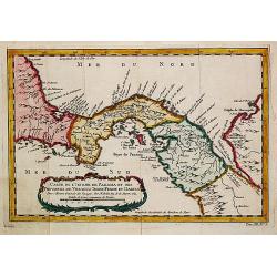
A Map of the Isthmus of Darien and Bay of Panama.
A fine little map featuring the Isthmus of Darien and Bay of Panama. Crrently, the country of Panama and the Panama Canal are located in this Isthmus. Block cartouche. T...
Date: London, 1756
Selling price: ????
Please login to see price!
Sold in 2013
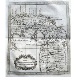
Carte des Provinces de Tierra Firme Darien Cartagene ..
Uncommon edition of this accurate map showing covering Panama and Colombia, the ranges and villages of numerous Indian tribes are shown.FromAtlas Portatif pour servir a l...
Date: Amsterdam, 1756
Selling price: ????
Please login to see price!
Sold in 2008
Carte de Isthme de Panama et des Provinces de Veragua, Terre Ferme, et Darien.
Jaques Nicolas Bellin (1702-720) was the most important French hydrographer of the 18th century. Sea-atlas 'Hydrographique Français' , 1756-65, atlas to accompany Prévost...
Date: Amsterdam, 1759
Selling price: ????
Please login to see price!
Sold in 2018
![[Lot of 10 maps /views of the Caribbeans], Terre Ferme, Isles Antilles et N.lle Espagne.](/uploads/cache/18346-(1)-250x250.jpg)
[Lot of 10 maps /views of the Caribbeans], Terre Ferme, Isles Antilles et N.lle Espagne.
Louis Brion de la Tour (1756-1823), ' Atlas Géneral, Civil et Ecclésiastique', 1766, ' Atlas Général', 1790-98. Louis Charles Desnos (fl.1750-70), Le Rouge's 'Atlas Nouv...
Date: Paris, c. 1760
Selling price: ????
Please login to see price!
Sold in 2022
Carta Rappresentante l'Istmo di Darien o'sia di Panama.
A charming map of Panama from Coltellinis Il Gazzettiere Americano. With several town named such as Porto Bello, Panama, Crux di Juan, and Nuova Edinburg. Includes also ...
Date: Livorno, 1763
Selling price: ????
Please login to see price!
Sold in 2017
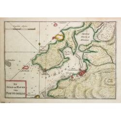
De Stad en Haven van Porto-Bello.
Izaak Tirion (d. 1769) Amsterdam publisher. His ' Nieuwe en beknopte handatlas' saw 6 editions between before 1740 and after 1784. Also ' Tegenwoordige staat van alle vol...
Date: Amsterdam, 1765
Selling price: ????
Please login to see price!
Sold
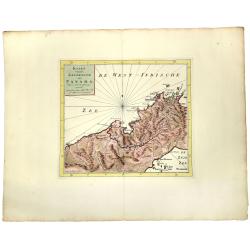
Kaart van de landengte van Panama.
Map of the Isthmus showing towns such as Panama, Chargres and Porto-Bello,&c., roads and villages of the time.
Date: Amsterdam, 1765
Selling price: ????
Please login to see price!
Sold in 2008
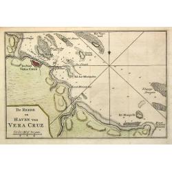
De Reede en Haven van Vera Cruz.
Izaak Tirion (d. 1769) Amsterdam publisher. His ' Nieuwe en beknopte handatlas' saw 6 editions between before 1740 and after 1784. Also ' Tegenwoordige staat van alle vol...
Date: Amsterdam,1765
Selling price: ????
Please login to see price!
Sold in 2020
Map of the Countries of the South Sea from Panama to Guayquil
A copperplate engraved map, published for the Rev. Dr. Robertson's History of America. By Thomas Kitchin, Senior, Hydographer to his Majesty.The map comprises the area no...
Date: London, 1777
Selling price: ????
Please login to see price!
Sold in 2017
Carte du Golphe du Mexique et des Isles Antilles reduite de la grande Carte Anglois de Popple.
A good example of the 1780 Dezauche edition of Buache's most important map of the West Indies. Centered primarily on Cuba, this substantial map covers all of Central Amer...
Date: Paris, 1780
Selling price: ????
Please login to see price!
Sold in 2021
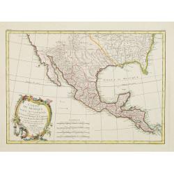
Carte du Mexique ou de la Nlle. Espagne..
Attractive map centered on Mexico, covering the whole Central America and the southern part of the United States.Ornated with a rococo title cartouche. Boundaries outline...
Date: Paris, ca 1783
Selling price: ????
Please login to see price!
Sold in 2008
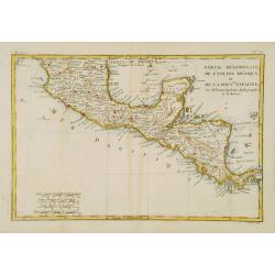
Partie Méridionale, de l'Ancien Méxique ou de la Nouv.le Espagne.
Copper engraved map of southern Mexico and all of Central America. Fine detail including shoals and navigational hazards along the coasts. Prepared by R.Bonne and include...
Date: Paris 1787
Selling price: ????
Please login to see price!
Sold

The Coast of Yucatan from Campeche to Ascension Bay with the West End of Cuba, ...
Double page sea chart showing the Yucatan Peninsula to the lower edge, the western tip of Cuba shown to the right edge. A quartered compass rose shown to lower right corn...
Date: London, Laurie and Whittle. 1794
Selling price: ????
Please login to see price!
Sold in 2020
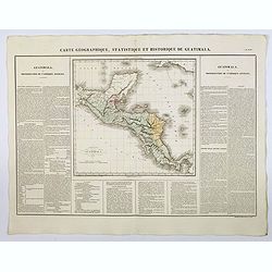
Carte Geographique, Statistique et Historique de Guatimala.
A nice detailed map of Guatemala from Buchon's Atlas Gégraphique Statistique, historique et chronologique des deux Ameriques et des isles adjacentes traduit de l'atlas ex...
Date: Paris, 1825
Selling price: ????
Please login to see price!
Sold in 2025
Guatemala.
This is the map of Guatemala is from a Plano edition of the very scarce German edition of Carey & Lea's "A Complete Historical, Chronological, and Geographical A...
Date: Weimar, 1822-1825
Selling price: ????
Please login to see price!
Sold
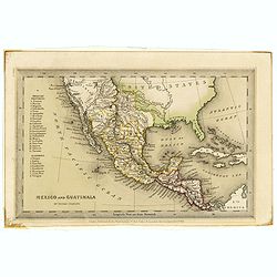
Mexico and Guatimala. By Thomas Starling.
A map that has Central America split into two regions; one outlined in red, the other in yellow. This is when Mexico still had possession of large swathes of California, ...
Date: London, ca. 1835
Selling price: ????
Please login to see price!
Sold in 2019
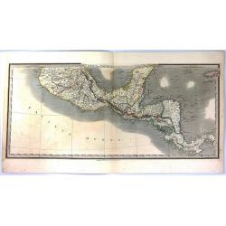
Mexico and Guatemala, Shewing the position of the Mines.
A large map of Central America extending from the southern half of Mexico to Panama, and including the Grand Cayman and Jamaica. This is the separate Central American map...
Date: London, 1841
Selling price: ????
Please login to see price!
Sold in 2016
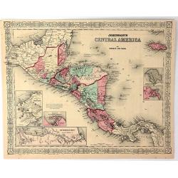
Johnson's Central America
A very pleasing map of Central America and Jamaica. Original hand colors surrounded by the usual fretwork border. From "Johnson's Atlas" by Johnson & Ward.
Date: New York, 1856
Selling price: ????
Please login to see price!
Sold in 2017
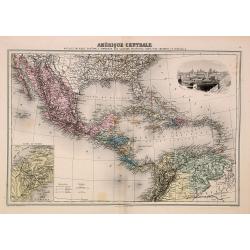
Amérique Centrale.
Decorative map of Central America from "Géographie Universelle, Atlas Migeon." published by J. Migeon. Nice steel engraving at the upper right hand of a view of...
Date: Paris, 1874
Selling price: ????
Please login to see price!
Sold in 2014
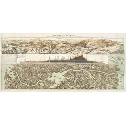
Panama Canal, Topographic, Diagramatic, and Illustrative.
Drawn in 1903, this "Topographic, Diagramatic, and Illustrative Map of the Panama Canal" illustrates the project for U.S. readers. The top panel depicts the exc...
Date: Washington, D. C., 1903
Selling price: ????
Please login to see price!
Sold in 2009
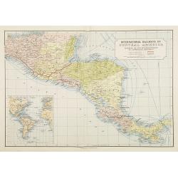
International Railways of Central America (chemins de fer internationaux de l'Amérique centrale).
Two colorful maps, a large one showing the railway systems in Central America by "International Railways of Central America" with a key to the ones unde...
Date: London, ca. 1910
Selling price: ????
Please login to see price!
Sold in 2009
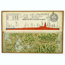
Souvenir Model of the Panama Canal.
A beautiful small profile map, on folding cardboard of the Panama Canal, by Maduro. The map is in raised profile, fully colored, and mounted on to original cardboard. The...
Date: Panama, 1911
Selling price: ????
Please login to see price!
Sold in 2019
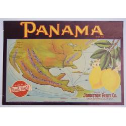
Panama.
A color printed vintage Panama Brand Lemon Crate Label, California Red Ball, Packed by Johnston Fruit Company, Santa Barbara, California.
Date: Sacramento, 1912
Selling price: ????
Please login to see price!
Sold in 2019
