Browse Listings in America
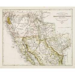
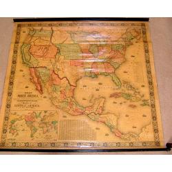
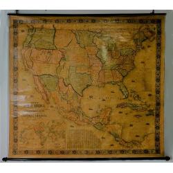
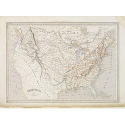
Vereinigte Staaten von Nord-America: Californien, Texas, und die Territorien New Mexico u. Utah.
Gold Regions tinted yellow. Very unusual combination of Texas and New Mexico configuration. California divided into ?Upper California?, which includes the Gold Regions an...
Date: Hildburghausen, 1852
Selling price: ????
Please login to see price!
Sold
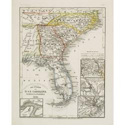
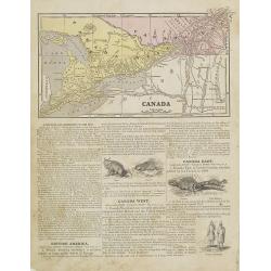
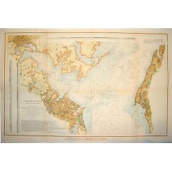
Die Staaten von N. & S. Carolina Georgia & Florida 1850.
Detailed map of Florida, North and South Carolina, with inset maps of St.Augustine, Newberne, Charleston and "Gold region von Nord -Carolina".Major ?roads? show...
Date: Hildburghausen, 1852
Selling price: ????
Please login to see price!
Sold
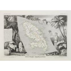
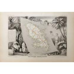
Colonies Françaises Martinique. Amérique du Sud. N°90.
Map of Martinique.A very decorative 19th century map of Martinique Island. The map is surrounded by the products of the island like tobacco, sugar, etc. A decoration of t...
Date: Paris, A. Combette, 1852
Selling price: ????
Please login to see price!
Sold in 2018
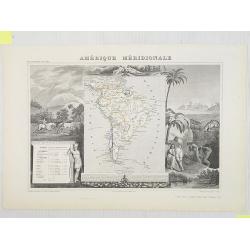
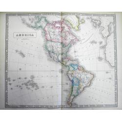
Amérique Méridionale.
Map of South America.Lovely map from one of the last decorative atlases of the nineteenth century.The rather simple map is framed by horses, Indians, jaguars, tapirs, and...
Date: Paris, A. Combette, 1852
Selling price: ????
Please login to see price!
Sold in 2009
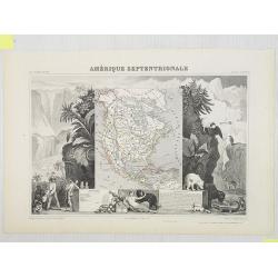
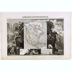
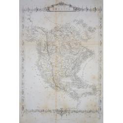
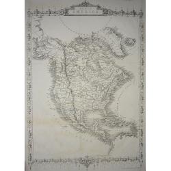
Amérique Septentrionale.
Map of North America showing the Republic of Texas, the United States extends into present-day Canada, Russia is in control of Alaska, and Mexico's northern border is acc...
Date: Paris, A. Combette, 1852
Selling price: ????
Please login to see price!
Sold in 2009
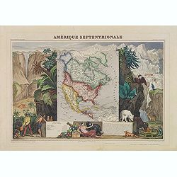
Amérique Septentrionale.
A very decorative map with the Republic of Texas, the United States extending into present-day Canada, Russia in control of Alaska, and Mexico's northern border according...
Date: Paris, A.Combette, ca. 1852
Selling price: ????
Please login to see price!
Sold in 2013
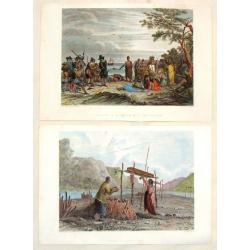
(2 Engravings) Interview of Massacoit with the Pilgrims and Feeding the Dead.
Two steel engravings featuring life among Native Americans in the early times. From "History of the Indian Tribes of the United States", published by Lippincott...
Date: Philadelphia, 1852
Selling price: ????
Please login to see price!
Sold in 2016
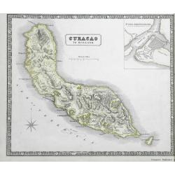
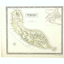
Curacao to Holland.
A detailed map of the island of Curaçao
Date: Liverpool, 1852
Selling price: ????
Please login to see price!
Sold in 2016
![Maury's wind & current chart 3rd edition 1849. no.8 series A. [with] Maury's wind & current chart 3rd edition 1852. no.2 series A. [with] Storm and rain chart of the north Atlantic. . .](/uploads/cache/39424-250x250.jpg)
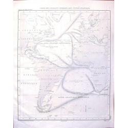
Maury's wind & current chart 3rd edition 1849. no.8 series A. [with] Maury's wind & current chart 3rd edition 1852. no.2 series A. [with] Storm and rain chart of the north Atlantic. . .
Three rare charts with winds and currents in the North Sea and Atlantic Ocean. - Maury's wind & current chart 3rd edition 1849. no.8 series A. - Maury's wind & c...
Date: USA, 1849, 1852
Selling price: ????
Please login to see price!
Sold in 2017
Amerique Septentrionale.
Beautiful map with the United States extending into present day Canada, Russia in control of Alaska and Mexico's northern border according to the Treaty of 1810. Surround...
Date: Paris, A. Combette, 1852
Selling price: ????
Please login to see price!
Sold in 2019
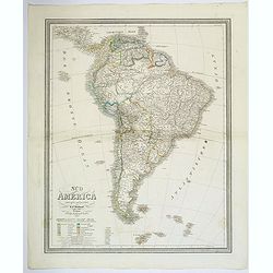
Sud America.
A lovely large map of South America, nicely colored by the newly formed independent countries, with a legend and mileage scales. With good map detail and competently engr...
Date: Weimar, ca 1852
Selling price: ????
Please login to see price!
Sold in 2020
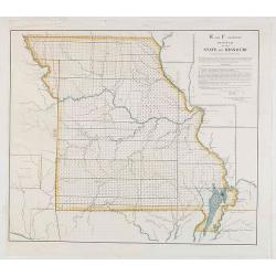
E and F (combined) Diagram of the State of Missouri.
Detailed land map of the state of Missouri, prepared by John G. Clark, William Dunn, William Shields and Aaron Snider and published by the Office of the surveyor general.
Date: Washington, 1852
Selling price: ????
Please login to see price!
Sold in 2021
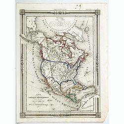
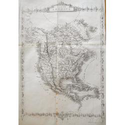
Carte de L'Amerique Septentrionale dresee et dessinee
An uncommon map of North America by J. G. Barbie du Bocage. It shows all of North America from the Arctic Circle to the northern most parts of South America. The US is sh...
Date: PARIS, 1852
Selling price: ????
Please login to see price!
Sold in 2020
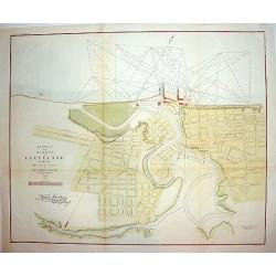
Survey of the Harbor of Cleveland Ohio..
An interesting and finely executed mid 19th century harbour survey and town plan of Cleveland. This lithographic work details the Cuyahoga River and topography of the cit...
Date: New York, ca 1853
Selling price: ????
Please login to see price!
Sold
New Map of that Portion of North America Exhibiting..
Full title: New Map of that Portion of North America Exhibiting the United States and Territories, the Canada's, New Brunswick, Nova Scotia and Mexico, also Central Ameri...
Date: Baltimore 1853
Selling price: ????
Please login to see price!
Sold
Vereinigte Staaten von Nord America und Mexico
Famous German steel-engraved map of the United States and Latin America, published in Stieler's Schul-Atlas. Includes much topographical detail and curiously shaped state...
Date: Gotha, c. 1853
Selling price: ????
Please login to see price!
Sold

United States and Canada 1853
The first Map Hitcheock,s landmark map of 1853 which is unchanged from the first edition of this report.
Date: Boston, 1853
Selling price: ????
Please login to see price!
Sold
America.
Large and detailed map of the Western Hemisphere. With "New California" labeled Russian America (Alaska) La Plata (pre Argentina) Unfinished coasts ...
Date: Liverpool, 1853
Selling price: ????
Please login to see price!
Sold in 2013
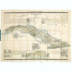
Posesiones de America : Isla de Cuba. . .
Wall size map of land areas showing all of Cuba, part of Florida Keys plus San Adios and Salvador Grande in the Bahamas.Minute topographical, political, and hydrographic ...
Date: Madrid, 1853
Selling price: ????
Please login to see price!
Sold in 2023
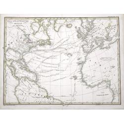
Der Atlantische Ocean
A very interesting map of the Atlantic Ocean, showing several routes (with dates) between Europe and the Americas. Includes the tracks of Columbus' first voyage, Humboldt...
Date: Gotha, 1853
Selling price: ????
Please login to see price!
Sold in 2016
New Map of the Portion of North America, Exhibiting the United States and Territories, The Canadas, New Brunswick, Nova Scotia, and Mexico also Central America, and the West India Islands.
Possibly the most interesting and attractive 19th-century wall map of North America. Published in 1853 by Jacob Monk, this large and beautiful wall map details much of No...
Date: Baltimore, 1853
Selling price: ????
Please login to see price!
Sold in 2018
A detailed map of the island of Curaçao.
A detailed map of the island of Curaçao showing settlements, roads, and the topography. An inset shows Fort Amsterdam with the battery, gallows, and fortifications.
Date: Liverpool, George Philip and Son, 1853
Selling price: ????
Please login to see price!
Sold in 2022
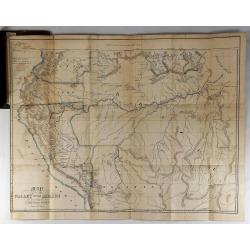
Map of the Valley of the Amazon To Accompany Lt. Herndon's Report.
This is one of three maps that accompanied Herndon's report, “Exploration of the Valley of the Amazon”. In 1851, Lieutenant Herndon was commissioned to lead the first...
Date: Baltimore, 1853
Selling price: ????
Please login to see price!
Sold in 2018
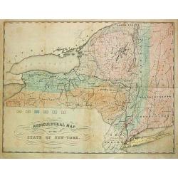
Agricultural Map of the State of New York.
A thematic map of New York State.
Date: New York, c. 1854
Selling price: ????
Please login to see price!
Sold in 2013
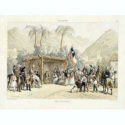
Historia de Chile. No. 20. Una chingana.
From "Historia de Chile." by Claudio Gay, a French naturalist, who was working under contract to the Chilean government between 1830-1833. Upon his return to Fr...
Date: Paris, 1854
Selling price: ????
Please login to see price!
Sold in 2014
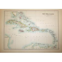
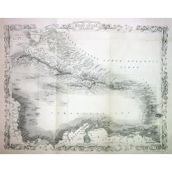
West India Islands
A superb map of the West Indies and the tip of Florida - Venezuela, drawn and engraved by William Hughes – Sidney Hall steel engraved. Published by Adam & Charles B...
Date: Edinburgh, 1854
Selling price: ????
Please login to see price!
Sold in 2016
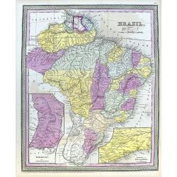
Brazil.
A fine map of Brazil, from Guiana and Venezuela in the north to Uruguay and Buenos Aires in the south. Filled with places names and also some reference to Indians. Two in...
Date: Philadelphia, 1854
Selling price: ????
Please login to see price!
Sold in 2020
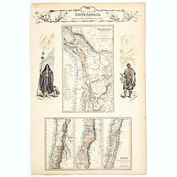
West Coast of South America including Chile & part of Bolivia & Peru.
A decorative regional map of South America, which contains 4 maps. The top map shows Peru and the neighboring Bolivian Table Lands, while and the 3 maps at the bottom dep...
Date: Edinburgh, 1854
Selling price: ????
Please login to see price!
Sold in 2020

Map of the States of California, Washington, Utah, New Mexico, & Oregon Territories
This map by one of the leading U.S. cartographic firms of the period, is an excellent example of American mapping at an important time in the development of the western U...
Date: Philadelphia, 1854
Selling price: ????
Please login to see price!
Sold in 2023
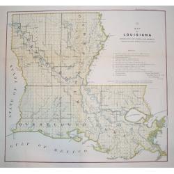
Map of Louisiana Representing the Several Land Districts
A handsome and very uncommon map of Louisiana. The work is a detailed survey of the State's various land divisions. A 12 point reference table provides letter coding and ...
Date: Donoldsonville, Louisiana, dated 1855
Selling price: ????
Please login to see price!
Sold
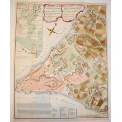
A Plan of the City of New York & its Environs to Greenwich.
A marvelous re-issue of Major John Montresor's famous and exceedingly scarce official plan of New York. This plan was specially commissioned by George Hayward in 1854 fo...
Date: New York, 1855
Selling price: ????
Please login to see price!
Sold
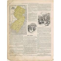
New Jersey.
From: System of Geography for the use of schools , published by Harper and brothers, 329 Pearl Street, New York.Page 37/38 from Sidney E. Morse's: System of Geography for...
Date: New York, 1855
Selling price: ????
Please login to see price!
Sold in 2015
West India Islands.
This is the uncommon and slightly later edition by Rapkin based on Tallis' maps. The vignettes have been removed and the map is issued in black and white. The map extends...
Date: London 1855
Selling price: ????
Please login to see price!
Sold
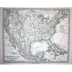
Etats-Unis. . .
Very detailed map of the United States of America, prepared by Auguste Henri Dufour (1798-1865). From La Terre Atlas Historique et Universel de Geographique. Published in...
Date: Paris, 1855
Selling price: ????
Please login to see price!
Sold in 2020
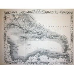
West India Islands
This is the uncommon and slightly later edition by Rapkin based on Tallis' maps. The vignettes have been removed and the map is issued in black and white. The map extends...
Date: London 1855
Selling price: ????
Please login to see price!
Sold
North America.
Important and uncommon later edition by Rapkin based on Tallis' maps. The vignettes have been removed and the map is issued in black and white. With decorative borders an...
Date: London 1855
Selling price: ????
Please login to see price!
Sold
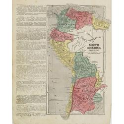
South America western part.
Map of western part of South America. From Sidney E. Morse''s: System of Geography for the use of schools , published by Harper and brothers, 329 Pearl Street, New York.A...
Date: New York, 1855
Selling price: ????
Please login to see price!
Sold in 2009
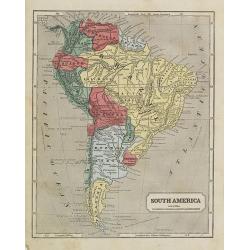
South America.
Map of the South American continent. From Sidney E. Morse''s: System of Geography for the use of schools , published by Harper and brothers, 329 Pearl Street, New York.An...
Date: New York, 1855
Selling price: ????
Please login to see price!
Sold in 2009
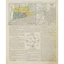
New England Southern Part.
Map of the southern part of New England specifically of Massachusetts, Connecticut and Rhode Island and Boston and its vicinities. On the verso, a world map of North and ...
Date: New York, 1855
Selling price: ????
Please login to see price!
Sold in 2015
Canada.
Map of Canada. On the verso, a world map of North and South America with its northern and southern hemispheres. From Sidney E. Morse''s: System of Geography for the use o...
Date: New York, 1855
Selling price: ????
Please login to see price!
Sold in 2015
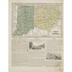
Ohio and Indiana.
Map of Ohio and Indiana. On verso a map of Iowa, Illinois and Missouri. From Sidney E. Morse''s: System of Geography for the use of schools , published by Harper and brot...
Date: New York, 1855
Selling price: ????
Please login to see price!
Sold in 2011
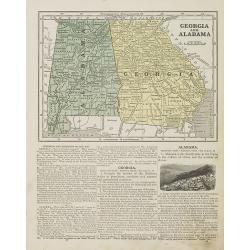
Georgia and Alabama.
Map of Georgia and Alabama. On verso a map of Louisiana, Mississippi and Arkansas. From Sidney E. Morse''s: System of Geography for the use of schools , published by Harp...
Date: New York, 1855
Selling price: ????
Please login to see price!
Sold in 2010
North America.
Important and uncommon later edition of Tallis map. The vignettes have been removed and the map is issued in black and white. Very detailed with numerous place names and ...
Date: London, c.1855
Selling price: ????
Please login to see price!
Sold in 2011
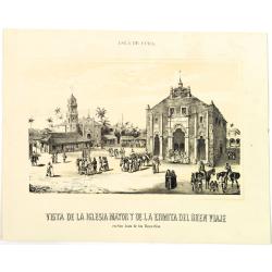
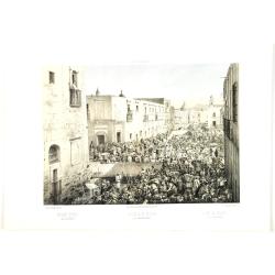
Vista de la iglesia mayor y de la ermita del buenviaje.
Decorative view of the High Church and the Hermitage of Good Voyages at San Juan de los Remedios, by un unknown lithographer after Frederico Mialhe (1810-1881).He is know...
Date: Havana, ca. 1855
Selling price: ????
Please login to see price!
Sold in 2010
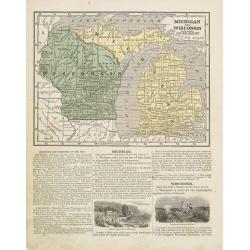
Michigan and Wisconsin
Map of Michigan and Wisconsin. Page 35/36 from Sidney E. Morse's: System of Geography for the use of schools , published by Harper and brothers, 329 Pearl Street, New Yor...
Date: New York 1855
Selling price: ????
Please login to see price!
Sold in 2011

Cavaliere Yuto e Capo Arrapohe & Capo Sioux Yanctons e Capo Ponkas. (2 prints)
Two chromolithograph prints of Native Americans including those from the Arrapoho and Ponka tribes. They are from an unidentified source by an anonymus artist. The publis...
Date: Rome, c.1855
Selling price: ????
Please login to see price!
Sold in 2016
North America.
Very detailed and up-to-date map of North America, from Russian America (Alaska) to Panama, including the West Indies. With numerous place names and Indian tribes! This ...
Date: London, ca. 1855
Selling price: ????
Please login to see price!
Sold in 2013
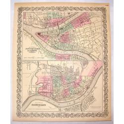
The Cities of Pittsburgh & Allegheny & The City of Cincinnati.
A hand-colored first edition of Colton's interesting two part map of Pittsburgh Pennsylvania and Cincinnati, Ohio. Interestingly, both maps are drawn to the same scale.
Date: New York, 1855
Selling price: ????
Please login to see price!
Sold in 2016
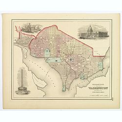
Georgetown and the City of Washington, the Capital of the United States of America.
An excellent 1855 example of Colton's plan of Washington D.C. and Georgetown. It covers the city in detail from Georgetown (Georgetown University, then College, shown) in...
Date: New York, 1855
Selling price: ????
Please login to see price!
Sold in 2018
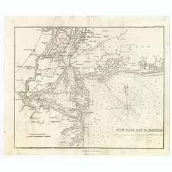
New York Bay & Harbor. . .
The chart provides a fantastically detailed look at the Harbor of New York and environs. The chart includes detailed depth soundings, and has a directional rose.The chart...
Date: London, ca 1855
Selling price: ????
Please login to see price!
Sold in 2018
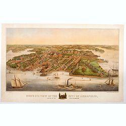
Bird's Eye View of the City of Annapolis, the Capitol of Maryland.
A wonderful large colored lithograph, by E. Sachse & Co., one of two important lithography companies operating in Baltimore during the mid nineteenth century, showing...
Date: Baltimore, ca 1855
Selling price: ????
Please login to see price!
Sold in 2020
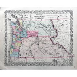
The Territories of Washington and Oregon.
Rare and early map of this region, in nice conditions.
Date: New York, 1855
Selling price: ????
Please login to see price!
Sold in 2022
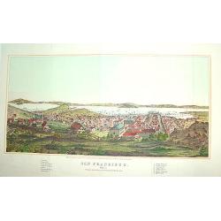
San Francisco
From Henry Bill's History of the World, a justly famous and sought after bird's-eye view of San Francisco published within seven years of the Gold Rush. It contains a leg...
Date: New York, 1856
Selling price: ????
Please login to see price!
Sold
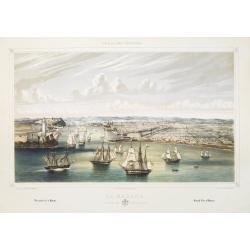
La Habana: vista general tomada desde la entrada del puerto.
A splendid, large lithographed view of the city of Havana as seen from the north, beautifully and subtly colored. The viewer is situated above the sea, looking into the m...
Date: Havana, Sergio Martin, 1856
Selling price: ????
Please login to see price!
Sold
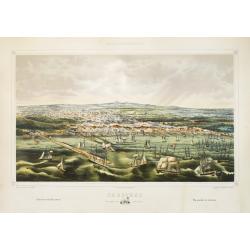
Cardenas Vista general tomada desde la Bahia.
A splendid, large lithographed view of the city of Cardenas, beautifully and subtly colored. The viewer is situated above the sea, looking to the harbour. Dozens of boats...
Date: Havana, Sergio Martin, 1856
Selling price: ????
Please login to see price!
Sold
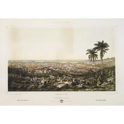
Trinidad Vista general tomada desde la loma de la Vijia.
A splendid, large lithographed view of the city of Trinidad, beautifully and subtly colored. The town is seen from above with in the background the Ocean. People in local...
Date: Havana, Gobierno, 1856
Selling price: ????
Please login to see price!
Sold
PATAPSCO RIVER AND THE APPROACHES
A large and wonderfuly detailed U. S. government chart of the Patapsco River and shoreline areas, including a finely engraved plan of Baltimore. The work contains a wealt...
Date: Washington D. C. , dated 1856
Selling price: ????
Please login to see price!
Sold
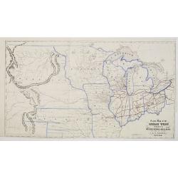
A New Map of the Great West Published by Miller, Orton & Mulligan, New York and Auburn. E. F. Beadle, Buffalo.
This map extends from Ohio to the Rocky Mountains, north of the Ohio River and Indian Territory, taken from "The States and Territories of the Great West", by J...
Date: Buffalo, 1856
Selling price: ????
Please login to see price!
Sold

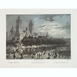
La Glorieta, en el interior del bosque de Chapultepec.
Two-shades plate taken from : México y sus alrededores (Mexico, Decaen, Portal del Coliseo Viejo, 1855-1856). With a key in English, Spanish and French.
Date: Mexico,1855-1856
Selling price: ????
Please login to see price!
Sold in 2011

La villa de Tacubaya, Tomada desde Chapultepec.
Two-shades plate taken from : México y sus alrededores (Mexico, Decaen, Portal del Coliseo Viejo, 1855-1856). With a key in English, Spanish and French.
Date: Mexico,1855-1856
Selling price: ????
Please login to see price!
Sold in 2011

Las Cadenas en una noche de luna.
Two-shades plate taken from : México y sus alrededores (Mexico, Decaen, Portal del Coliseo Viejo, 1855-1856). With a key in English, Spanish and French.
Date: Mexico,1855-1856
Selling price: ????
Please login to see price!
Sold in 2011

Interior de la Catedral de México, . . .
Two-shades plate taken from : México y sus alrededores (Mexico, Decaen, Portal del Coliseo Viejo, 1855-1856). With a key in English, Spanish and French.
Date: Mexico,1855-1856
Selling price: ????
Please login to see price!
Sold in 2011

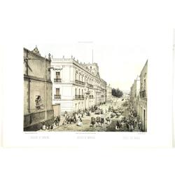
Road from Tacubaya to Chapultepec. Dresses of Mexivan Indians. - Camino de Tacubaya a Chapultepec. Trajes de Indios Mexicanos.
The plate has caption title in English, Spanish and French, from the rare publication MEXICO Y SUS ALREDEDORES, the most elaborate and important Mexican lithographic book...
Date: Mexico, Establecimiento Litografico de Decaen, 1855-1856
Selling price: ????
Please login to see price!
Sold in 2020

Iturbide Market Old St. John square. - El Mercado de Iturbide Antiqua plaza de San Juan.
The plate has caption title in English, Spanish and French, from the rare publication MEXICO Y SUS ALREDEDORES, the most elaborate and important Mexican lithographic book...
Date: Mexico, Establecimiento Litografico de Decaen, 1855-1856
Selling price: ????
Please login to see price!
Sold in 2016
College of miners. - Collegio de mineria.
College of miners. The plate has caption title in English, Spanish and French, from the rare publication MEXICO Y SUS ALREDEDORES, the most elaborate and important Mexica...
Date: Mexico, Establecimiento Litografico de Decaen, 1855-1856
Selling price: ????
Please login to see price!
Sold in 2012
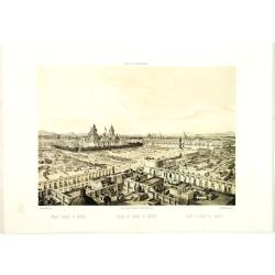
Public square of Mexico. - Plaza de armas de México.
The plate has caption title in English, Spanish and French, from the rare publication MEXICO Y SUS ALREDEDORES, the most elaborate and important Mexican lithographic book...
Date: Mexico, Establecimiento Litografico de Decaen, 1855-1856
Selling price: ????
Please login to see price!
Sold

Square of Ste. Domingo. - Plaza de Santo Dimingo.
The plate has caption title in English, Spanish and French, from the rare publication MEXICO Y SUS ALREDEDORES, the most elaborate and important Mexican lithographic book...
Date: Mexico, Establecimiento Litografico de Decaen, 1855-1856
Selling price: ????
Please login to see price!
Sold in 2020
Public square of Mexico. - Plaza de armas de México.
The plate has caption title in English, Spanish and French, from the rare publication MEXICO Y SUS ALREDEDORES, the most elaborate and important Mexican lithographic book...
Date: Mexico, Establecimiento Litografico de Decaen, 1855-1856
Selling price: ????
Please login to see price!
Sold in 2020
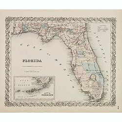
FLORIDA.
First edition. Issue with decorative borders. Fine map of Florida with smaller inset map "Plan of the Florida Keys". Of particular interest is the Arredondo Gra...
Date: New York, c. 1856
Selling price: ????
Please login to see price!
Sold in 2014
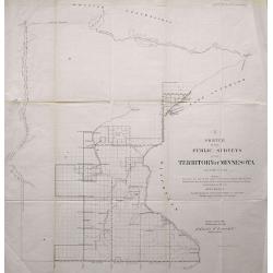
LOT OF 2: SKETCH OF THE PUBLIC SURVEYS IN THE TERRITORY OF MINNESOTA & SKETCH OF THE PUBLIC SURVEYS IN WISCONSIN AND TERRITORY OF MINNESOTA
Pair of lithographed maps of Minnesota and Wisconsin showing the Township boundaries for 1856. Included are rivers and towns.
Date: 1856
Selling price: ????
Please login to see price!
Sold in 2013
Las Cadenas en una noche de luna. - The Chains by Moonlight.
The Chains by Moonlight. The plate has caption title in English, Spanish and French, from the rare publication México y sus alrededores, the most elaborate and important...
Date: Mexico, Establecimiento Litografico de Decaen, 1855-1856
Selling price: ????
Please login to see price!
Sold in 2015
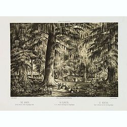
La Glorieta, en el interior del bosque de Chapultepec. - The Bower. In the interior of the Chapultepec Park.
The Bower. In the interior of the Chapultepec Park. The plate has caption title in English, Spanish and French, from the rare publication México y sus alrededores, the m...
Date: Mexico, Establecimiento Litografico de Decaen, 1855-1856
Selling price: ????
Please login to see price!
Sold in 2013
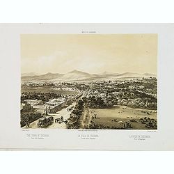
La villa de Tacubaya, Tomada desde Chapultepec. - The town of Tacubaya. Taken from Chapultepec.
The town of Tacubaya, seen from Chapultepec. The plate has caption title in English, Spanish and French, from the rare publication México y sus alrededores, the most ela...
Date: Mexico, Establecimiento Litografico de Decaen, 1855-1856
Selling price: ????
Please login to see price!
Sold in 2013
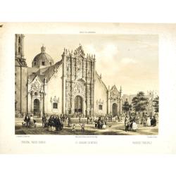
Principal Parish Church - El Sagrario de México. - Paroisse principale.
Fine lithographed plate of the Metropolitan Cathedral of the Assumption of Mary of Mexico City. The plate has caption title in English, Spanish and French, from the rare ...
Date: Mexico, Establecimiento Litografico de Decaen, 1855-1856
Selling price: ????
Please login to see price!
Sold in 2020
Carte des Courants Generaux dans L'Ocean Anlantique.
Fine lithographed sea chart by Depot des Cartes et Plans de la Marine featuring the sea currents in the Atlantic Ocean. It was engraved by Jacobs from drawings by Charles...
Date: Paris, 1856
Selling price: ????
Please login to see price!
Sold in 2016
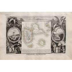
Colonies Françaises. Martinique. Amérique du Sud.
Beautiful map from one of the finest decorative atlases of the nineteenth century. The map is surrounded with engravings depicting the countryside with trade goods includ...
Date: Paris 1856
Selling price: ????
Please login to see price!
Sold in 2016
Colonies Françaises (en Amérique).
Beautiful map from one of the finest decorative atlases of the nineteenth century. A highly decorative 19th century map showing the islands of St Martin, St Pierre et Miq...
Date: Paris 1856
Selling price: ????
Please login to see price!
Sold in 2016
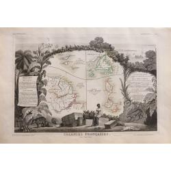
Colonies Francaises en Amérique: Guadeloupe, Marie-Galante, St Martin, La Désirade, Les Saintes, Anguilla.
Beautiful map from one of the finest decorative atlases of the nineteenth century. A highly decorative 19th century map showing the islands of Guadeloupe, Marie-Galante, ...
Date: Paris 1856
Selling price: ????
Please login to see price!
Sold in 2016
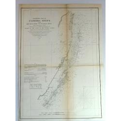
Preliminary Chart of Florida Keys from Key Biscayne to Pickles Reef
Detailed chart of Florida reefs with soundings. From a Trigonometrical Survey under the direction of A.D. Bache, Superintendent of the Survey of the coast of the United S...
Date: New York, 1856
Selling price: ????
Please login to see price!
Sold in 2018

Iron R.M. Steamship “Persia”_ Cunard Line - Currier
Fine colored lithograph or chromolithograph featuring the steamship Persia of the Cunard Line. It was produced in about 1838 by Currier & Ives and is signed in print ...
Date: New York, 1856
Selling price: ????
Please login to see price!
Sold in 2017