Browse Listings in America
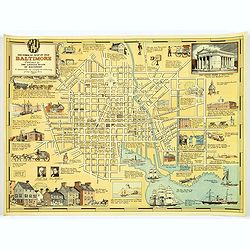
Historical Map of Old Baltimore.
A lovely, detailed map of the old 'downtown' area of Baltimore.
Date: Baltimore, 1954
Selling price: ????
Please login to see price!
Sold in 2017
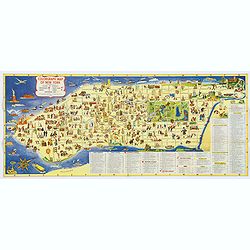
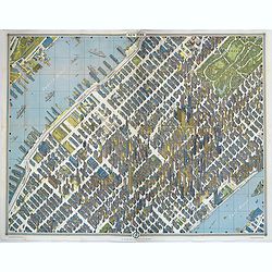
Colorgraph Map of New York.
A colorful, lively map of lower Manhattan, from Harlem south to the Battery. Numerous (380) small color illustrations throughout, depicting all that life in NYC has to of...
Date: New York, 1954
Selling price: ????
Please login to see price!
Sold in 2017

Historical Map of Old Baltimore.
A lovely, detailed map of the old 'downtown' area of Baltimore, with its streets well laid out, with numerous small vignette pictures illustrating historic events and ill...
Date: Baltimore, 1954
Selling price: ????
Please login to see price!
Sold in 2019
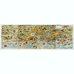
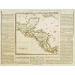
Within the Golden Gate. A survey of the History, Resources, and Points of Interest. . .
A nicely produced brochure of the area around San Francisco, with a delightful fully colored pictorial map of the area as the front and back covers for the brochure. The...
Date: San Francisco, 1955
Selling price: ????
Please login to see price!
Sold in 2020
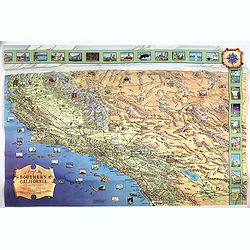
A Pictorial Map of Southern California and adjacent areas.
A beautiful folding map of Southern California, taking the geography from San Francisco to San Diego and the Mexican border. As well as plenty of physical map detail, the...
Date: Los Angeles, ca. 1960
Selling price: ????
Please login to see price!
Sold in 2017
![Skiing map and Information. [Camp Fortune]](/uploads/cache/40048-250x250.jpg)
Skiing map and Information. [Camp Fortune]
A nice folding map of the Camp Fortune Ski area 25 miles from downtown Ottawa.Map takes the form of showing all the various tracks and routes available to skiers at Camp ...
Date: Ottawa, ca. 1960
Selling price: ????
Please login to see price!
Sold in 2017
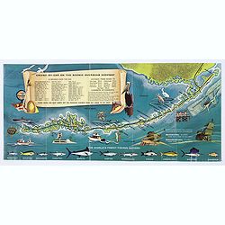
Florida Keys & Key West. . .
A folding map (brochure) advertising the many attractions of the Florida Keys and Key West. Map. The map is illustrated by a number of cartoonish vignettes of local wildl...
Date: Miami, aftrer 1960
Selling price: ????
Please login to see price!
Sold in 2020

The Times Map Of The Trans-Antarctic Expedition Antarctica South Pole Vivian Fuchs Edmund Hillary.
Original vintage advertising poster - The Times Map of the Trans-Antarctic Expedition 1957-1958 Feature articles by Dr Vivian Fuchs and Sir Edmund Hillary on the Trans-An...
Date: England, 1960
Selling price: ????
Please login to see price!
Sold in 2023
![[Golden Gate Bridge San Francisco]](/uploads/cache/46709-250x250.jpg)
[Golden Gate Bridge San Francisco]
Signed lithograph view of the Golden Gate Bridge in San Francisco, by E.R.
Date: ca. 1960
Selling price: ????
Please login to see price!
Sold in 2020

California.
"CALIFORNIA" advertising poster for AIR France, design by Guy Georget (1911-1992).His “California” poster from 1963 flirts with cubism. The white outline ar...
Date: Paris, S.A.Courbet, 1963
Selling price: ????
Please login to see price!
Sold in 2020

New York.
Perhaps one of the greatest cartographic feats of all time, this 1963 'bird's eye view' map of New York City was the first such produced for almost a century. Amazingly, ...
Date: New York, 1963
Selling price: ????
Please login to see price!
Sold in 2018
New York.
Perhaps one of the greatest cartographic feats of all time, this 1963 'bird's eye view' map of New York City was the first such produced for almost a century. Amazingly, ...
Date: New York, 1963
Selling price: ????
Please login to see price!
Sold in 2019
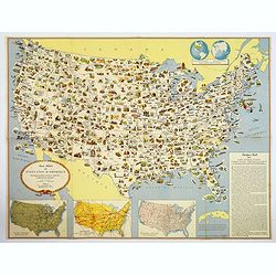
Carte Illustree des Etats-Unis d'Amerique Principaux produits, resources regionales, et particularites physiques.
A decorative French map of the United States' main products, regional resources and physical features. The map is covered with many small pictorial vignettes highlighting...
Date: Washington D.C., ca. 1965
Selling price: ????
Please login to see price!
Sold in 2018
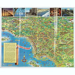
A Pic-Tour map of Southern California.
A highly colorful and attractive pictorial travel map of southern California, from Santa Barbara, southward to San Diego & Tijuana. Major streets, highways, attractio...
Date: San Francisco, ca 1965
Selling price: ????
Please login to see price!
Sold in 2019
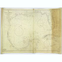
Gulf of Mexico.
A large sea chart of the Gulf of Mexico 'from Admiralty Charts and US Government charts, corrected to 1966'. (In fact there are corrections up until 1977).Chart extent is...
Date: London, 1882 corrected to 1966
Selling price: ????
Please login to see price!
Sold in 2017

Canada.
Decorative poster advertising flights to Canada made by Georges Mathieu. The poster is one of a series of 15 composed of posters of Greece, Israel, Germany, Great Britain...
Date: Paris, 1967
Selling price: ????
Please login to see price!
Sold in 2023
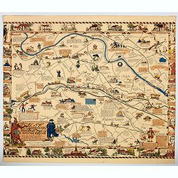
The Main Line. A Historical Map of Ye Outlying Regions . . .
A pictorial map depicting the geography, history and landmarks of the Main Line, the informal name for a group of western suburbs of Philadelphia, Pennsylvania. The area ...
Date: Philadelphia, 1975
Selling price: ????
Please login to see price!
Sold in 2020
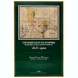
Crossroads of Empire. Early Maps of Texas and the Southwest 1513 - 1900
Poster made for the exhibit 'Crossroads of Empire: Printed Maps of Texas and the Southwest, 1513-1900' at the Amon Carter Museum, Fort Worth" June 11–July 26, 1981...
Date: Fort Worth, 1981
Selling price: ????
Please login to see price!
Sold in 2021

The Military Invasion of American Schools.
An interesting offset colour printed lithograph map / poster of the United States that is liberally covered in symbols of either black triangles or red circles, both high...
Date: New York, 1984
Selling price: ????
Please login to see price!
Sold in 2023

Ronald Reagan.
Original drawing representing a caricature of Ronald Reagan.Born in 1958, Jan Op De Beeck was elected in 2003 as 'World's Best Caricaturist' by the Professional cartoonis...
Date: Belgium, 1987
Selling price: ????
Please login to see price!
Sold
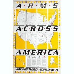
Arms Across America Waging Third World War.
This is a striking propaganda map, created by The War Registers League, founded 100 years ago in the U.S. it continues today as a secular, pacifist organization dedicated...
Date: New York, 1989
Selling price: ????
Please login to see price!
Sold in 2023
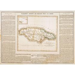
Jamaica.
This is the map of Jamaica is from a plano edition of the very scarce German edition of Carey & Lea's "A Complete Historical, Chronological, and Geographical Ame...
Date: Weimar, 1822-25
Selling price: ????
Please login to see price!
Sold
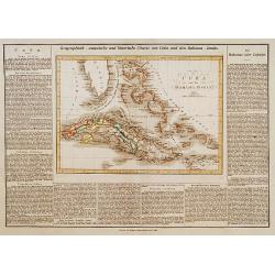
Cuba und die Bahama Inseln.
This is the map of Cuba, includes the Bahama's and southern tip of Florida is from a plano edition of the very scarce German edition of Carey & Lea's "A Complete...
Date: Weimar, 1822-25
Selling price: ????
Please login to see price!
Sold
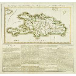
Hayti.
This is the map of Haiti is from a plano edition of the very scarce German edition of Carey & Lea's "A Complete Historical, Chronological, and Geographical Ameri...
Date: Weimar, 1822-25
Selling price: ????
Please login to see price!
Sold
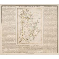
Vereinigte Provinzen von Süd America.
This is the map of Chilli and part of Brazil, part of Argentina and Paraguay is from a plano edition of the very scarce German edition of Carey & Lea's "A Comple...
Date: Weimar, 1822-25
Selling price: ????
Please login to see price!
Sold
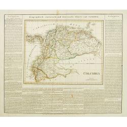
Columbia.
This is the map of Columbia is from a plano edition of the very scarce German edition of Carey & Lea's "A Complete Historical, Chronological, and Geographical Am...
Date: Weimar, 1822-25
Selling price: ????
Please login to see price!
Sold
Guatemala.
This is the map of Guatemala is from a Plano edition of the very scarce German edition of Carey & Lea's "A Complete Historical, Chronological, and Geographical A...
Date: Weimar, 1822-25
Selling price: ????
Please login to see price!
Sold
![La Florida [with] Guastecan [with] Peruviae Auriferae Regionis Typus.](/uploads/cache/83483-250x250.jpg)
La Florida [with] Guastecan [with] Peruviae Auriferae Regionis Typus.
Three-in-one map from a Ortelius' "Theatrum Orbis Terrarum" Atlas published in Antwerp 1572/1598, Dutch language edition. Showing: Florida and the south, after...
Date: Antwerp, 1572/98
Selling price: ????
Please login to see price!
Sold in 2019
Colombia prima or South America..
Very detailed map of South America in two sheets. With table showing civil divisions with square miles and population. In lower part of the map three altitude insets afte...
Date: London 1855/64
Selling price: ????
Please login to see price!
Sold
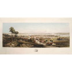
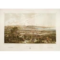
Panorama of Havana.
A fine, large colored steel engraving showing a panoramic view of Havana and its harbour as seen from the south or southeast. The city centre is depicted in remarkable de...
Date: [Havana, G.B. Haase, 1854].
Selling price: ????
Please login to see price!
Sold
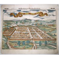
Il Cuscho Citta Principale Della Provincia Del Peru.
A 1550's decorative bird's-eye view of Cusco, from a German edition of Münster's 'Cosmographia', one of the most influential geographical works of the 16th century. One ...
Date: Basel, ca 1550
Selling price: ????
Please login to see price!
Sold in 2020
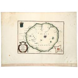
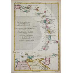
Isola di MARIA GALANTE neel Antilli. . .
A nice example of Coronelli's map of the island of Maria Galante, from his 'Isolario Dell'Atlante Veneto'. This is one of the few separate maps of the island of Marie-Gal...
Date: Venice, ca 1690
Selling price: ????
Please login to see price!
Sold in 2020
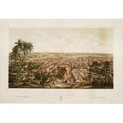
Matanzas: vista g'ral tomada desde el monte del Cafetal de..
Large colored lithograph from the series ,Isla de Cuba Pintoresca., Matanzas: vista g'ral tomada desde el monte del Cafetal de D. Vicente Guerrero. A large lithographed v...
Date: Havana, Sergio Martin, [1856?].
Selling price: ????
Please login to see price!
Sold
Puerto-Principe: vista g'ral tomada desde El Cristo.
Large colored lithograph from the series ,Isla de Cuba Pintoresca.A splendid, large lithographed view of the city of Puerto-Principe, (now Camag³ey) as seen from the eas...
Date: Havana, Lith. del Gobierno, [1856?].
Selling price: ????
Please login to see price!
Sold
Carte Generale des Decouvertes de l'Amiral de Fonte, . . (Explorers)
An interesting map of the NW Coast of America and the NE Coast of Asia, based upon Jefferys map of 1768. Prior to Cook's 1st Voyage, the English, French and Russians were...
Date: Paris, 1770ca
Selling price: ????
Please login to see price!
Sold in 2020
Amplissimae Regionis MISSISSIPI Seu Proninciae Ludovicianae.
A striking hand-colored example of Homann's map of the Course of the Mississippi River, based upon the reports of Hennepin, who explored the upper Mississippi and Great L...
Date: Nuremberg, ca 1720
Selling price: ????
Please login to see price!
Sold in 2019
Nieuwe en Naaukeurige Paskaart van Het Eyland Hispaniola of St. Domingo met alle dresslss Havenen, Dieptens en Ankergronden, als meede de door passeeringe tusche de Caiques en andere Eylanden. naer de Opservatien van Monsr. Frezier. . .​
This rare magnificent large chart of Hispaniola and Puerto Rico was published by Johannes van Keulen II. The chart was compiled from the chart made by Amedee Francois Fre...
Date: Amsterdam, ca. 1742
Selling price: ????
Please login to see price!
Sold in 2018
KAART van de LANDENGTE van PANAMA.
A detailed hand colored map of Panama, published in Amsterdam by Isaak Tirion. It depicts the City of Panama at the southeast, Chagres at the northwest and Porto-Bello at...
Date: Amsterdam, ca 1745
Selling price: ????
Please login to see price!
Sold in 2019
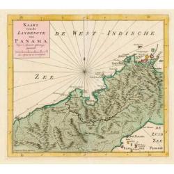
Kaart van de Landengte van Panama.
Izaak Tirion (d. 1769) Amsterdam publisher. His ' Nieuwe en beknopte handatlas' saw 6 editions between before 1740 and after 1784. Also ' Tegenwoordige staat van alle vol...
Date: Amsterdam, c. 1745.
Selling price: ????
Please login to see price!
Sold in 2015
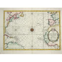
Carte de l' Ocean Occidental.
Jaques Nicolas Bellin (1702-720) was the most important French hydrographer of the 18th century. Sea-atlas 'Hydrographique Français' , 1756-65, atlas to accompany Prévo...
Date: Paris, 1746.
Selling price: ????
Please login to see price!
Sold
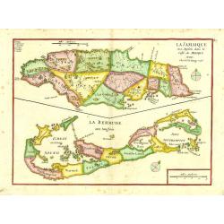
La Jamaique..Golfe du Mexique/ La Bermude.
"Two maps on one sheet; Jamaica and Bermuda. George Louis Le Rouge was active from 1740- till 1780 as a publisher, and was appointed engineer for the King of France....
Date: Paris 1748.
Selling price: ????
Please login to see price!
Sold
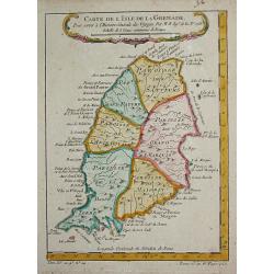
Carte de l' Isle de la Grenade.
Jaques Nicolas Bellin (1702-720) was the most important French hydrographer of the 18th century. Sea-atlas 'Hydrographique Français' , 1756-65, atlas to accompany Prévo...
Date: Paris, c.1755.
Selling price: ????
Please login to see price!
Sold
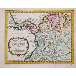
Carte des Provinces de Tierra Firme, Darien, Cartagene et Nouvelle Grenade.
Jaques Nicolas Bellin (1702-720) was the most important French hydrographer of the 18th century. Sea-atlas 'Hydrographique Français' , 1756-65, atlas to accompany Prévo...
Date: Paris, 1756.
Selling price: ????
Please login to see price!
Sold in 2008
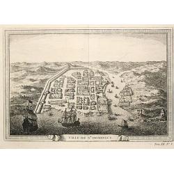
Ville de St. Domingue.
An attractive view of the town of St. Domingue.
Date: Paris, c. 1760.
Selling price: ????
Please login to see price!
Sold
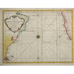
Carte de l Ocean Meridional, 1746.
Jaques Nicolas Bellin (1702-720) was the most important French hydrographer of the 18th century. Sea-atlas 'Hydrographique Français', 1756-65, atlas to accompany Prévos...
Date: Amsterdam, c. 1760.
Selling price: ????
Please login to see price!
Sold
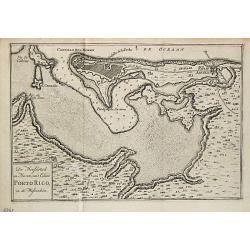
De Hoofdstad en Haven van 't Eiland Porto Rico in de Westindien.
Izaak Tirion (d. 1769) Amsterdam publisher. His 'Nieuwe en beknopte handatlas' saw 6 editions between before 1740 and after 1784. Also 'Tegenwoordige staat van alle volke...
Date: Amsterdam, 1765.
Selling price: ????
Please login to see price!
Sold
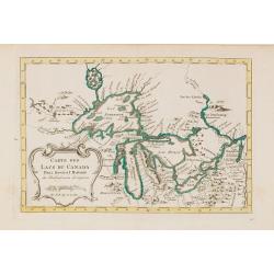
Carte des Lacs du Canada..
Scarce edition of this accurate map showing the all the Great Lakes in the traditional Bellin configuration.Kershaw does not mention this state with in lower right corner...
Date: Amsterdam, 1773.
Selling price: ????
Please login to see price!
Sold in 2014
Carte des Isles Antilles ou du Vent avec la Partie orientale des Isles sous le Vent.
Rigobert Bonne (1727-1795), French cartographer. His maps are found in a.o. Atlas Moderne (1762), Raynal's Histoire Philos. du Commerce des Indes (1774) and Atlas Encyclo...
Date: Paris, 1774.
Selling price: ????
Please login to see price!
Sold
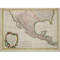
Carte du Mexique ou de la N.lle Espagne Contenant aussi le Nouveax Mexique, la Californie, avec une partie des Pays adjacents.
"Jean Lattré, Paris-based engraver and publisher. Worked with Robert de Vaugondy, J. Janvier and R. Bonne. "" Atlas Monderne', 1771, 1783 , 1793. Rigobert...
Date: Paris, 1783.
Selling price: ????
Please login to see price!
Sold
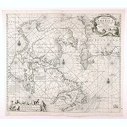
Pascaarte vande Noorder Zee Custen van America, vande West-Hoeck van Ysland doorde...
Fourth and last edition of van Keulen's chart of the Arctic Canada with the Hudson Bay and the supposed Northwest Passage. First published in 1680. The map is based upon ...
Date: Amsterdam, 1728-80
Selling price: ????
Please login to see price!
Sold in 2020
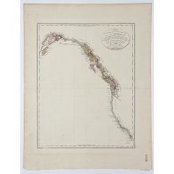
Carte de la partie de la Cote nord-ouest de l' Amerique.
A detailed and rare map of the Gulf of Alaska, British Columbia, and south to St.Francisco. Prepared by Edward Roberts after information by George Vancouver and engraved ...
Date: Paris, ca. 1800
Selling price: ????
Please login to see price!
Sold in 2017
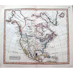
North America.
An interesting steel engraved map showing Mexico reaching until Mendocino and Utah Lake! Locates Texas, Cabo San Lucas, New Madrid in Missouri, etc. Names Indian nations,...
Date: Anon, ca 1820?
Selling price: ????
Please login to see price!
Sold in 2018
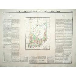
Carte Géographique .. Indiana.
\"Detailed map of Indiana. From J.A. Buchon, \"\"Atlas Gégraphique Statistique, historique et chronologique des deux Ameriques et des isles adjacentes; tr...
Date: Paris 1825.
Selling price: ????
Please login to see price!
Sold
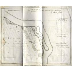
Land District North of Red River in the Sate of Louisiana.
An unusual map from an American land survey report, surveyed in 1823 by Maxfield Ludlow, and ordered by The House of Commons in 1827. It shows the Mississippi River with ...
Date: London, 1828?
Selling price: ????
Please login to see price!
Sold in 2018
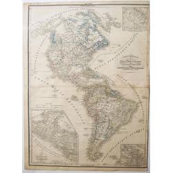
CARTE GENERALE des Deux Ameriques.
An interesting old colored lithographed map of the American continent, with the Independent Texas Republic. From a french atlas by G.Heck.There are 3 inset maps of - the ...
Date: Paris, ca 1835
Selling price: ????
Please login to see price!
Sold in 2021

Washinga Sahba's Grab.../ Tombeau de Wachinga Sahba.../ Washinga Sahba's Grave on Blackbird's Hill.
Aquatint from: 'Reise in das innere Nord-America in den Jahren 1832-1834' by Prince Maximilian of Wied-Neuwied, after paintings by Karl Bodmer, engraved by Lucas Weber, p...
Date: London, 1842
Selling price: ????
Please login to see price!
Sold in 2016
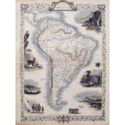
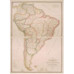
South America.
Detailed map of South America from the famous Atlas by John Tallis. With many place names, regions, and countries shown.Highly decorative map with ornamental borders, sev...
Date: London, ca. 1850
Selling price: ????
Please login to see price!
Sold in 2015

A set of 15 humorous prints. 1846, 1857, 1858, 1862, 1863, 1864, 1866. 1882, 1896. All with American, Civil War, Oregon Treaty and Abraham Lincoln interest
A set of 15 humorous prints. 1846, 1857, 1858, 1862, 1863, 1864, 1866. 1882, 1896. All with American, Civil War, Oregon Treaty and Abraham Lincoln interest.Mostly engrav...
Date: London 1846 - 1896
Selling price: ????
Please login to see price!
Sold in 2015
!["Nederlandsch West - Indië. [7 maps on one sheet, including Curaç.]"](/uploads/cache/15951-250x250.jpg)
"Nederlandsch West - Indië. [7 maps on one sheet, including Curaç.]"
"An excellent engraving of the Dutch possessions in the West Indies. Seven maps on one sheet, Surinam, St. Martin, Bonaire, Curaç, Aruba, St.Eustatius and...
Date: The Netherlands c.1900.
Selling price: ????
Please login to see price!
Sold
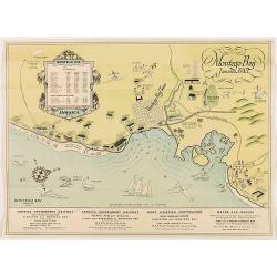
Montego Bay Jamaica, B.W.L.
Beautiful vintage pictorial tourist map of the Montego Bay in Jamaica, with key to distances to hotels and guest houses. In lower part publicity for railway and motor car...
Date: London,
Selling price: ????
Please login to see price!
Sold in 2020
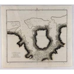
Sketch of the Harbours on the North Side of Eimeo (Taloo Harbour).
A chart showing what is now called Cook's Bay on the island of Moorea (Society Islands) in the French Polynesia. This chart appeared in; "A Voyage to the Pacific Oce...
Date: New York,
Selling price: ????
Please login to see price!
Sold in 2019
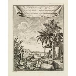
Raccolta del Cotone.
Attractive view on a cotton plantation. The scene is explained through a key index on top.It represents black people at work for the Europeans' supplying of cotton and il...
Date: [No Title]
Selling price: ????
Please login to see price!
Sold