Browse Listings in America
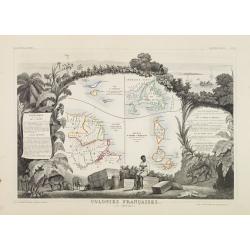
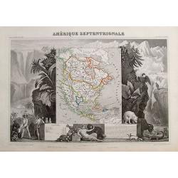
Colonies Françaises (en Amérique.)
A very decorative 19th century map showing the islands of St Martin, St Pierre et Miquelon and Terra Nova. Includes also Guyana. The map is surrounded by portraits, anima...
Date: Paris 1850
Selling price: ????
Please login to see price!
Sold
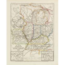
Die Staaten von Missouri, Illinois, Indiana, Ohio, Kentucky.
Detailed map of Missouri, Illinois, Indiana, Ohio, Kentucky and Tennessee with numerous physical and political features including mines, settlements, trails/roads, forts ...
Date: Hildburghausen/ Philadelphia 1850
Selling price: ????
Please login to see price!
Sold
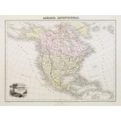
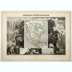
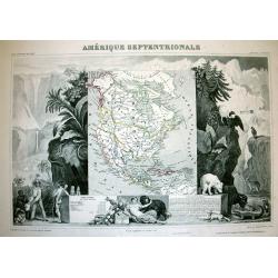
Amérique Septentrionale.
A nice map of the continent showing the national boundaries, but not the individual states and provinces.The United States is shown with its boundary with Canada complete...
Date: Paris 1850
Selling price: ????
Please login to see price!
Sold
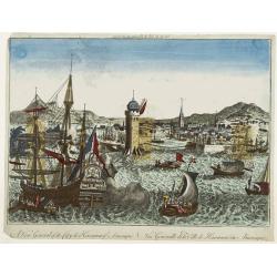
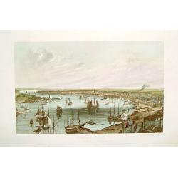
A view general of the City de Havana of Amerique. / Vue generale de ..
Very decorative and colorful panoramic view over Havana harbour. Engraved for a Vue d'Optique, it was designed to be viewed in a special apparatus that gave the scene a s...
Date: Ca. 1850
Selling price: ????
Please login to see price!
Sold
![Opperhoofd der Vos Indiaanen. [Fox indians]](/uploads/cache/23391-250x250.jpg)
Opperhoofd der Vos Indiaanen. [Fox indians]
Decorative, hand colored, woodcut engraving illustrating the chief of the Fox Indian tribe.After a war with the Illinois (c.1765), the Fox moved into Illinois territory. ...
Date: Amsterdam, ca. 1850
Selling price: ????
Please login to see price!
Sold in 2016
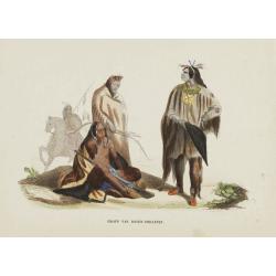
Groep van Raven-Indiaanen.
Decorative, original hand colored, woodcut engraving illustrating a group of Native Americans belonging to the Raven tribe.
Date: Amsterdam, ca. 1850
Selling price: ????
Please login to see price!
Sold in 2016
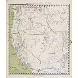
Californien, Oregon Utah und Neu-Mejico.
An attractive lithographed map of western America with original coloring by Carl Flemming.Oregon is essentially the same as on the Mitchell map, above, but modern Califor...
Date: Glogau ca 1850
Selling price: ????
Please login to see price!
Sold
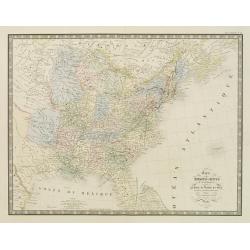
Carte des Etats-Unis d''''Amérique comprenant une Partie des Districts de l''''Ouest et de la Nouvelle Bretagne..
Map of the states east of the Mississippi and the adjacent Indian Territories to the west. Texas is shown as a separate state.Relief shown by hachures. From the Atlas cl...
Date: Paris, 1850
Selling price: ????
Please login to see price!
Sold in 2020
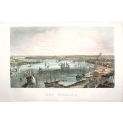
New Orleans
A beautifully rendered mid nineteenth century view of New Orleans, centered on the Mississippi River and the city's harbor. Many important sites are depicted as part of t...
Date: New York, ca. 1850
Selling price: ????
Please login to see price!
Sold in 2008
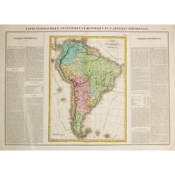
Carte Géographique, Statistique et Historique de l'Amerique Meridionale.
A fine, detailed map of South America with on both sides explanetary text.From "J.A. Buchon Atlas Gégraphique Statistique, historique et chronologique des deux Amé...
Date: Paris, 1850
Selling price: ????
Please login to see price!
Sold in 2016
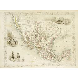
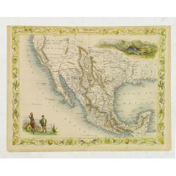
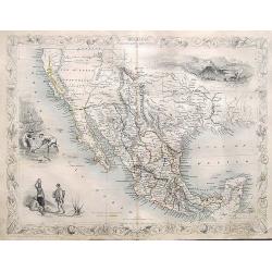
Mexico, California and Texas.
Excellent and important map to show the goldrush in California. After gold was discovered in California, the plate was re-engraved to include a vignette of gold washing a...
Date: London, c1850
Selling price: ????
Please login to see price!
Sold in 2008
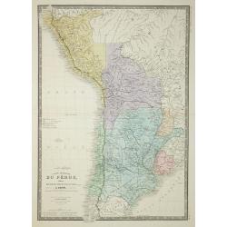
Carte Generale du Perou de la Bolivie, du Chili, et la Plata.
Map of the western part of South America, from Atlas Universel De Geographie Physique, Politique, Ancienne Et Moderne …, published by Ch. Delagrave.
Date: Paris, 1850
Selling price: ????
Please login to see price!
Sold in 2011

Cercanias de Baracoa ?
From Album pintoresco de la isla de Cuba - La Havane.
Date: Hamburg and Berlin, c.1850
Selling price: ????
Please login to see price!
Sold in 2009
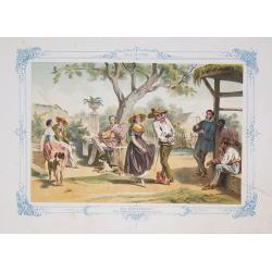
El Zapateado ?
From Album pintoresco de la isla de Cuba - La Havane.
Date: Hamburg and Berlin, c.1850
Selling price: ????
Please login to see price!
Sold in 2009
Mexico, California and Texas.
Excellent and important map to show the goldrush in California. After gold was discovered in California, the plate was re-engraved to include a vignette of gold washing a...
Date: London, c1850
Selling price: ????
Please login to see price!
Sold in 2010
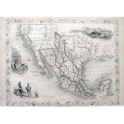
Mexico California and Texas.
John Tallis and John Rapkin's highly desirable map of Mexico, Texas, and Upper California. The “Great Caravan Route” used by covered wagons during the westward expans...
Date: London, Edinburgh, Dublin, c.1850
Selling price: ????
Please login to see price!
Sold in 2012
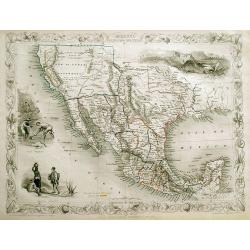
Mexico, California and Texas.
Excellent and important map to show the goldrush in California. After gold was discovered in California, the plate was re-engraved to include a vignette of gold washing a...
Date: London, c1850
Selling price: ????
Please login to see price!
Sold in 2013
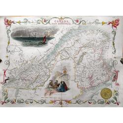
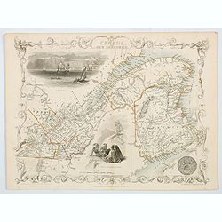
EAST CANADA AND NEW BRUNSWICK.
Detailed map of the area from Montreal to New Brunswick. Highly decorative map with an inset view of Quebec, a scene of North American Indians, and the ornamental borders...
Date: London, c1850
Selling price: ????
Please login to see price!
Sold in 2013
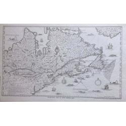
Champlain's Map of New France 1632.
FROM 1850 NEW YORKSTATE HISTORY. - A nineteenth century lithograph reproduction of a seminal map.
Date: (1632) 1850
Selling price: ????
Please login to see price!
Sold in 2014
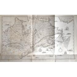
Champlain's Map of New France 1632.
FROM 1850 NEW YORKSTATE HISTORY. A nineteenth century lithograph reproduction of a seminal map.
Date: New York, 1850
Selling price: ????
Please login to see price!
Sold in 2015
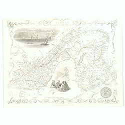
British Guayana.
Pleasing map of British Guyana with four fine lithographed vignettes of scenes from Guyana. It was drawn and engraved by J. Rapkin and published in London by John Tallis ...
Date: London, 1850
Selling price: ????
Please login to see price!
Sold in 2016
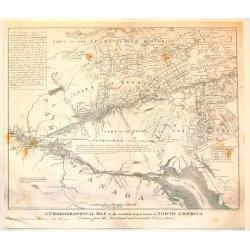
A Chorographical Map of the Northern department of North America.
A detailed map of the United States and Canada showing Lake Ontario and the St. Lawrence River at the bottom with New Hampshire at the top. This is a smaller edition of a...
Date: New Haven, 1850
Selling price: ????
Please login to see price!
Sold in 2015
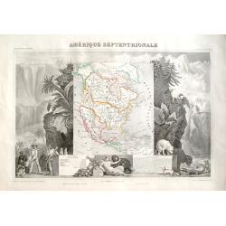
Amérique Septentrionale.
Important French map of North America, showing Texas as an independent republic. The population table lists Texas with 200.000 and the United States with 19.000.000 inha...
Date: Paris, ca. 1850
Selling price: ????
Please login to see price!
Sold in 2018
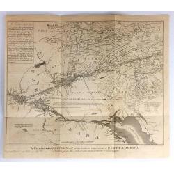
A Chorographical Map of the Northern Department of North America.
A Chonographical Map of the Northern Department of North America.A detailed map that shows the Townships or Land Grants found in portions of New Hampshire, Vermont, and N...
Date: New Haven, 1850
Selling price: ????
Please login to see price!
Sold in 2017
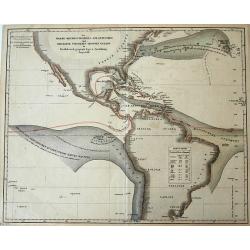
Der Warme Meeresstrom des Atlantischen und der Kalte Strom des Grossen Oceans...
Unusual thematic map of the ocean currents around the Americas. Lists the temperatures of the Gulf Stream and the Equatorial current's.
Date: Gota, ca. 1850
Selling price: ????
Please login to see price!
Sold in 2016
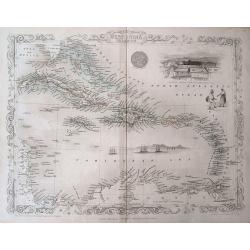
West India Islands.
Beautiful map of the Caribbean - from Florida to Venezuela. Decorated with the embellished borders, a view of Kingston in Jamaica, sailing ships, and a native couple. Exc...
Date: London, ca. 1850
Selling price: ????
Please login to see price!
Sold in 2016
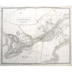
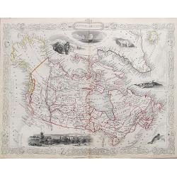
Canada
A large and highly detailed map of the area between Lake Huron and the Gulf of the Saint Lawrence River, complete with references to the Townships, notes about Indians, a...
Date: Edinburgh, ca 1850
Selling price: ????
Please login to see price!
Sold in 2016
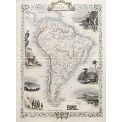
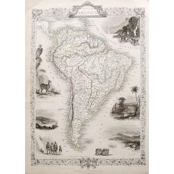
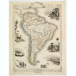
South America.
A detailed map of South America from the famous Atlas by John Tallis. With many place names, regions, and countries shown.Highly decorative map with ornamental borders, s...
Date: London, ca 1850
Selling price: ????
Please login to see price!
Sold in 2017
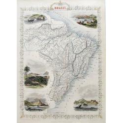
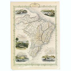
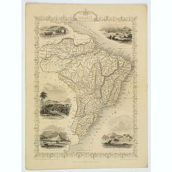
Brazil
A very decorative steel-engraved map of Brazil, highly detailed with place names, rivers, hills, bays, etc. Attractively illustrated with vignette style views of "Bo...
Date: London, ca 1850
Selling price: ????
Please login to see price!
Sold in 2017
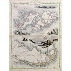
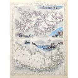
Falkland Islands and Patagonia.
Two very decorative steel-engraved maps on one sheet. Both maps are very detailed with place names, rivers, hills, islands, bays, etc.Attractively illustrated with vignet...
Date: London, ca.1850
Selling price: ????
Please login to see price!
Sold in 2017
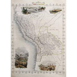
Peru & Bolivia
A very decorative steel-engraved map extending from Guayaquil southwards until the Atacama. Very detailed with place names, rivers, hills, bays, etc.Attractively illustra...
Date: London, ca.1850
Selling price: ????
Please login to see price!
Sold in 2017
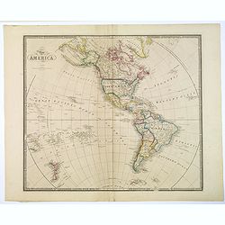
Map of America.
A large map of the Americas, and the Western hemisphere, including New Zealand, Polynesia, Greenland etc. Each country colored in outline color. Major cities, waterways a...
Date: London ca.1850
Selling price: ????
Please login to see price!
Sold in 2018
South America.
A detailed map of South America from the famous atlas by John Tallis. With many place names, regions, and countries shown. A highly decorative map with ornamental borders...
Date: London, ca. 1850
Selling price: ????
Please login to see price!
Sold in 2017
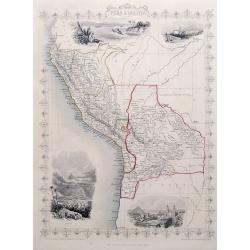
Peru & Bolivia.
A very decorative steel-engraved map extending from Guayaquil southwards until the Atacama. Very detailed with place names, rivers, hills, bays, etc.Attractively illustra...
Date: London, ca. 1850
Selling price: ????
Please login to see price!
Sold in 2018
Falkland Islands and Patagonia.
Two very decorative steel-engraved maps on one sheet. Both maps are very detailed with place names, rivers, hills, islands, bays, etc.Attractively illustrated with vignet...
Date: London, ca. 1850
Selling price: ????
Please login to see price!
Sold in 2020
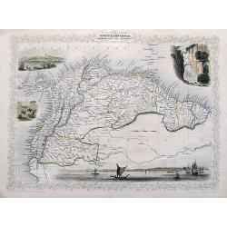
Venezuela, New Granada, Equador, and The Guayanas.
A highly decorative steel-engraved map from Panama to French Guayana. Very detailed with place names, rivers, hills, bays, etc. Attractively illustrated with vignette sty...
Date: London, ca. 1850
Selling price: ????
Please login to see price!
Sold in 2018
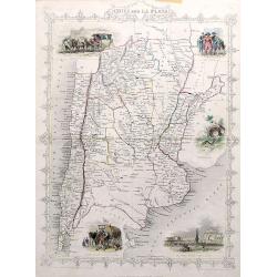
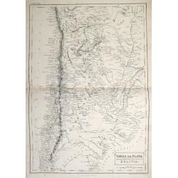
Chili and La Plata.
A very decorative steel-engraved map extending from the border of Bolivia until Patagonia, with northern Chile and northern Argentina. Very detailed with place names, riv...
Date: London, ca. 1850
Selling price: ????
Please login to see price!
Sold in 2017
Mexico, California and Texas.
An excellent and important map that shows the Californian gold-rush of the 1840s. After gold was discovered in California, the plate was re-engraved to include a vignett...
Date: London, ca. 1850
Selling price: ????
Please login to see price!
Sold in 2017
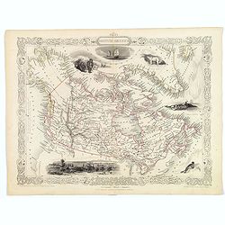
British America.
A very decorative steel-engraved map of Canada, highly detailed with place names, rivers, mountains, islands, bays, etc. Attractively illustrated with vignette style vie...
Date: London, ca. 1850
Selling price: ????
Please login to see price!
Sold in 2017
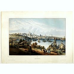
Baltimore.
Beautiful lithography of Baltimore after a design by Louis Le Breton (1818 Douarnenez - 1866 Paris). He drew this charming view as one of a series showing major ports of ...
Date: Paris, Auguste Bry, ca. 1850
Selling price: ????
Please login to see price!
Sold in 2018
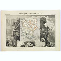
Amerique Septentrionale.
A beautiful map of the United States with Texas as a Republic, and extending into present day Canada, Russia in control of Alaska, and Mexico's northern border defined ac...
Date: Paris, ca 1850
Selling price: ????
Please login to see price!
Sold in 2018
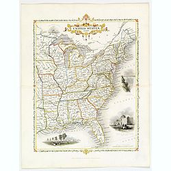
United States, East..
A delightful small map of the eastern portion of the United States, by Alfred Adlard, published in his Vignette Modern School Atlas of the World. When looking at this map...
Date: London, 1850
Selling price: ????
Please login to see price!
Sold in 2020
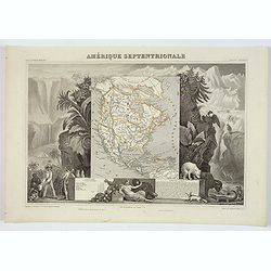
Amérique Septentrionale.
An important French map of North America, showing Texas within Mexico. The population table lists Texas with 200.000 and the United States with 19.000.000 inhabitants. Th...
Date: Paris, ca 1850
Selling price: ????
Please login to see price!
Sold in 2018
Amerique Septentrionale.
A beautiful map of the United States with Texas as a Republic, and extending into present day Canada, Russia is in control of Alaska, and Mexico's northern border defined...
Date: Paris, ca 1850
Selling price: ????
Please login to see price!
Sold in 2020
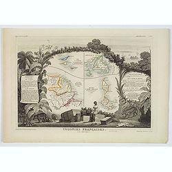
Colonies Françaises (en Amérique.)
A very decorative 19th-century map showing the French Colonies in the Americas, the islands of St Martin, St Pierre et Miquelon and Terra Nova. Includes also Guyana. The ...
Date: Paris, 1850
Selling price: ????
Please login to see price!
Sold in 2021
Amerique Septentrionale.
A beautiful map of the United States with Texas as a Republic, and extending into present day Canada, Greenland and the Arctic are shown, Russia is in control of Alaska, ...
Date: Paris, ca 1850
Selling price: ????
Please login to see price!
Sold in 2020

Wa-Em-Boesh-Kaa, A Chippeway Chief
A beautifully defined lithograph of a Chippewa chief, from Mckeeney and Hall?s Indian Tribes of North America, perhaps the most important work ever published on North Ame...
Date: Philadelphia, ca.1851
Selling price: ????
Please login to see price!
Sold
Amérique Septentrionale
Important French map of North America, showing Texas as an independent republic. The population table lists Texas with 200.000 and the United States with 19.000.000 inhab...
Date: Paris 1851
Selling price: ????
Please login to see price!
Sold in 2008
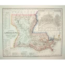
Neueste Karte von Lousiana.
This highly attractive work is from the German edition of the Tanner / Mitchell Louisiana map, forming part of the NEW UNIVERSAL ATLAS. It shows a German title with place...
Date: Hidleburgh, dated 1851
Selling price: ????
Please login to see price!
Sold in 2011
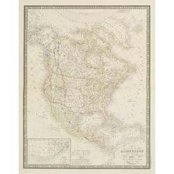
Carte de l'Amerique du Nord...
Excellent detailed map of North America, including early western Territorial borders : only OR, CA, NM, UT, TX and NE in the west as well as Russian America.Nice detail t...
Date: Paris, 1851
Selling price: ????
Please login to see price!
Sold in 2019
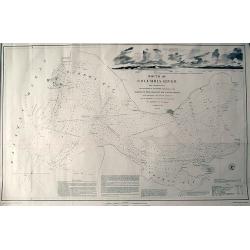
Mouth of Columbia River...
Large and very detailed chart of the Columbia River entering the Pacific Ocean near Astoria, Oregon. With numerous depth soundings and observations on the approach. I...
Date: United States, 1851
Selling price: ????
Please login to see price!
Sold in 2011
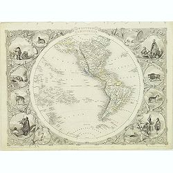
Western Hemisphere.
Decorative steel engraved map of Western Hemisphere, surrounded 12 decorative vignettes. Taken from "The illustrated atlas and modern history of the world by John Ta...
Date: London, 1851
Selling price: ????
Please login to see price!
Sold in 2012
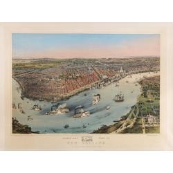
Birds' eye view of New Orleans. . .
A panoramic view of New-Orleans drawn from nature on stone by J.Bachman. Bird's-eye view of The Big Easy spread out along the banks of the Mississippi, upon which steambo...
Date: New York, 1851
Selling price: ????
Please login to see price!
Sold in 2015
Chile, La Plata or the Argentine Republic and Bolivia.
A fine example of Adam and Charles Black's 1851 map of Chile, the Argentine Republic and part of Bolivia. The map illustrates Bolivia's claims to the Atacama Desert and a...
Date: Edinburgh, 1851
Selling price: ????
Please login to see price!
Sold in 2013
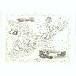
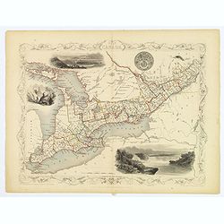
East Canada and New Brunswick.
This is John Tallis’ map of East Canada, or what is now Quebec and New Brunswick. Includes Montreal, Quebec City, and the St. Lawrence River valley. Features five vigne...
Date: London, 1851
Selling price: ????
Please login to see price!
Sold in 2016
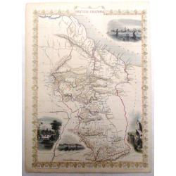
British America.
A decorative and useful map of modern day Canada, when it was still under British rule in the mid nineteenth century. Provinces are outlined in red, with additional annot...
Date: London, 1851
Selling price: ????
Please login to see price!
Sold in 2016
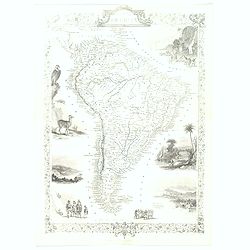
South America.
This is John Tallis’ pretty map of South America. The map is surrounded by a number of topical steel engraved vignettes and the whole is surrounded by a decorative vine...
Date: London, 1851
Selling price: ????
Please login to see price!
Sold in 2016
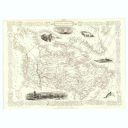
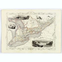
West Canada.
This is John Tallis’ attractive map of West Canada. The map is surrounded by a number of topical steel engraved vignettes, including Niagara Falls, Kingston, Indians, B...
Date: London, 1851
Selling price: ????
Please login to see price!
Sold in 2016
Nuova California (Stati Uniti de l'America Settentrionale).
This scarce Italian map of the western USA, which is based on Hypolite Ferry's map of 1850, has additional extensive notes on the history and resources of the region.A su...
Date: Naples, 1851
Selling price: ????
Please login to see price!
Sold in 2018
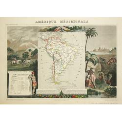
Amerique Meridionale.
A decorative map of South America showing political divisions in color. The map is surrounded by steel engraved scenes including horses, Indians, jaguars, tapirs, mining ...
Date: Paris, 1851
Selling price: ????
Please login to see price!
Sold in 2018
British America.
A decorative and useful map of modern day Canada, when it was still under British rule in the mid nineteenth century. Provinces are outlined in red, with additional annot...
Date: London, 1851
Selling price: ????
Please login to see price!
Sold in 2022
Brazil.
A highly decorative and detailed map of Brazil which was drawn and engraved by J. Rapkin (vignettes by H. Winkles & W. Lacey ). Showing Boats on Lake Negro, Monte Vid...
Date: London, Edinburgh & Dublin 1851
Selling price: ????
Please login to see price!
Sold in 2020
West Canada.
This is John Tallis’ attractive map of West Canada. The map is surrounded by a number of topical steel engraved vignettes, including Niagara Falls, Kingston, Indians, B...
Date: London, 1851
Selling price: ????
Please login to see price!
Sold in 2018
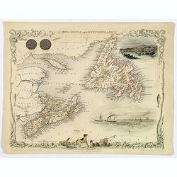
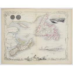
Nova Scotia and Newfoundland.
A decorative and attractive map of the Canadian provinces of Nova Scotia and Newfoundland. The map is enhanced by the seals of both provinces, plus delightful vignettes o...
Date: London, 1851
Selling price: ????
Please login to see price!
Sold in 2020
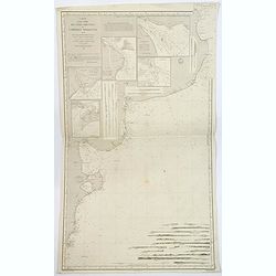
Carte d'une partie des Cotes Orientales de L'Amerique Meridionales. . .
A large marine chart of the eastern coast of Argentina, from the mouth of the River Plate, south to the Gulf of St. George. Filled with nautical information depth levels,...
Date: Paris, 1851
Selling price: ????
Please login to see price!
Sold in 2019
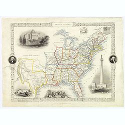
United States.
This is John Tallis’ pretty map of the United States, published mid nineteenth century. The map is surrounded by a number of delightful steel engraved vignettes and the...
Date: London, 1851
Selling price: ????
Please login to see price!
Sold in 2018
West Canada.
This is John Tallis’ attractive map of West Canada. The map is surrounded by a number of topical steel engraved vignettes, including Niagara Falls, Kingston, Indians, B...
Date: London, 1851
Selling price: ????
Please login to see price!
Sold in 2019
Brazil.
A highly decorative and detailed map of Brazil which was drawn and engraved by J. Rapkin (vignettes by H. Winkles & W. Lacey ). Showing Boats on Lake Negro, Monte Vid...
Date: London, Edinburgh & Dublin 1851
Selling price: ????
Please login to see price!
Sold in 2021
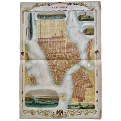
New York.
Rare, double page map of New York by John Tallis with 6 beautiful vignettes. Includes vignettes of City Hall, the Custom's House, the Narrow's from Fort Hamilton, a New ...
Date: London, 1851
Selling price: ????
Please login to see price!
Sold in 2019
Nova Scotia and Newfoundland.
Double page steel engraved map, accompanied by vignette illustrations of Halifax and cod fishing off Newfoundland. Decorative scrolling and title cartouche around the edg...
Date: London & New York: John Tallis & Company, 1851
Selling price: ????
Please login to see price!
Sold in 2023
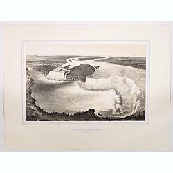
Vue Generale du Niagara a Vol d'Oiseau.
A spectacular view of Niagara Falls, the Horseshoe Falls in the foreground looking upstream towards Lake Erie. It was lithographed by Eugene Ciceri (1813 -90) after the v...
Date: Paris, ca 1851
Selling price: ????
Please login to see price!
Sold in 2021
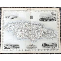
Jamaica
Fantastic map of Jamaica from the famous Atlas by John Tallis & company published in London & New York around 1850.It shows the island in great detail, filled wit...
Date: London & New York, c1851
Selling price: ????
Please login to see price!
Sold in 2021
South America.
This is John Tallis’ pretty map of South America. The map is surrounded by a number of topical steel engraved vignettes and the whole is surrounded by a decorative vine...
Date: London, 1851
Selling price: ????
Please login to see price!
Sold in 2023
East Canada and New Brunswick.
This is John Tallis’ map of East Canada, or what is now Quebec and New Brunswick. Includes Montreal, Quebec City, and the St. Lawrence River valley. Features four vigne...
Date: London, 1851
Selling price: ????
Please login to see price!
Sold in 2023
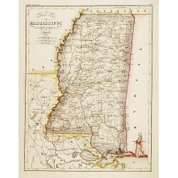
Neueste Karte von Mississippi..
Detailed map of the state Mississippi with numerous physical and political features including mines, settlements, trails/roads, forts and Indian areas. From "Meijers...
Date: Hildburghausen/ Philadelphia 1852
Selling price: ????
Please login to see price!
Sold
New Orleans from the Lower Cotton Press
A beautifully defined panoramic view of New Orleans as seen in the late 1840s / early 1850s. The harbor scene depicts numerous sailing ships, steamboats and other vessels...
Date: New York, 1852
Selling price: ????
Please login to see price!
Sold
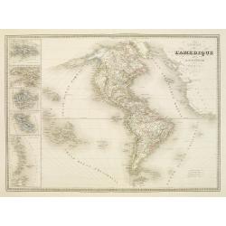
Amérique.
Fine manuscript map of America with relief shown pictorially. Inset map of Central America called Guatemala in the left hand side.Signed by the author in the lower right ...
Date: Paris, 1852
Selling price: ????
Please login to see price!
Sold in 2017
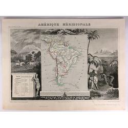
Amerique Meridionale.
A decorative map of South America from levasseur's 'Atlas national Illustre des 86 Departements et des possesions de la France'.
Date: Paris, 1852
Selling price: ????
Please login to see price!
Sold
Die Staaten von New York, Pensylvania, Maryland, New Jersey.
Including the states of New York, Pennsylvania, Maryland, New Jersey, Delaware and Virginia. With inset plans of New York, Philadelphia, Niagara Falls, Albany, Pittsburgh...
Date: Hildburghausen & Philadelphia, 1852
Selling price: ????
Please login to see price!
Sold in 2011
Carte de l'Amerique..
Very detailed map of the western hemisphere, prepared by Auguste Henri Dufour (1798-1865). Published by Mrs. V.Turgis, rue Serpentine in Paris. To the left inset maps of ...
Date: Paris, 1852
Selling price: ????
Please login to see price!
Sold in 2023