Please login to see price!.
Subscribe to be notified if similar examples become available.
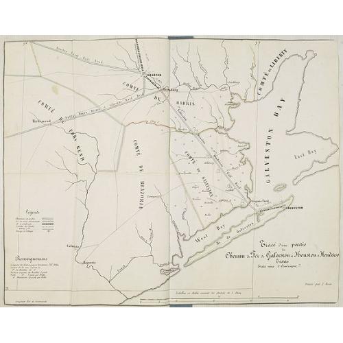
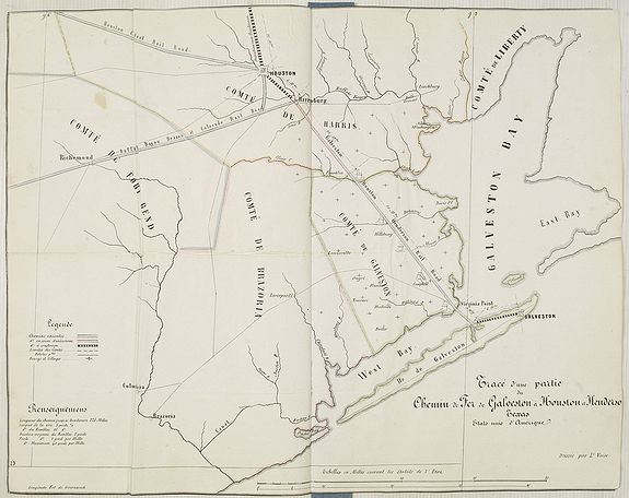
Tracé d'une partie du Chemin de Fer de Galveston à Houston et Henderson. Texas Etats Unis D'Amerique. |
||||||||||||||||||||
|
||||||||||||||||||||
|
|
||||||||||||||||||||
|
Selling price: $...
Please login to see price! Sold in 2010 Missed this item! Be the first to get notified about our newly added listings. Add your name to our mailing list. Feel free to contact us if you have a question about this item. |
Virtual Collection - Save and collect this or any of your favorite items in one place.
If you want to save the items permanently, please sign in or create account first. |
|||||||||||||||||||
Description
Hand colored map of the area between Galveston, Harrisburg, Richmond and Houston, showing "Galveston, Houston & Henderson railroad", also "Buffalo Bayou Brazos and Colorado Rail Road" and "Houston Central rail Road".
According to a color code at the left, the existing rail road system is colored in blue. Two small connections of the "Galveston, Houston & Henderson railroad" are at the time under construction and colored in red.
Two little pieces one between Harrisburg into the direction of Houston, and one trestle across Galveston Bay to Virginia Point are in their planning stage.
The trestle across Galveston Bay, built from the proceeds of a Galveston County bond issue, was finished in 1860, thus completing the rail line between the two cities.
This is probably one of the earliest railroad maps of the region around Houston.
The "Galveston, Houston, & Henderson Railroad" was raising money in London and Paris in 1857 to finance expansion. This map was likely lithographed in Paris, and probably accompanied the French bond prospectus.
The Galveston, Houston & Henderson was completed from Galveston to Houston in 1857.
The Galveston, Houston and Henderson Railroad Company was chartered on February 7, 1853, to build from Galveston through Houston to Henderson. The early incorporators included W. C. Lacy, T. P. Anderson, R. A. Harris, and William M. Tuck. The company was an important carrier as it was, for a number of years, Galveston's only rail connection with the Texas railroad system centering at Houston. Although supported in Galveston and Houston, much of the early financing was provided by investors in Holland and France. Construction of the "Old Reliable Short Line," as the road was later called, began at Virginia Point on the mainland opposite Galveston Island in 1854. However, the first rail was not laid until 1857 and in 1859 the company finally reached Houston, where it terminated at the corner of Main and McKinney. Only two curves, one on either side of Harrisburg, were required between Virginia Point and Houston. A trestle across Galveston Bay, built from the proceeds of a Galveston County bond issue, was finished in 1860, thus completing the rail line between the two cities.
The original company was sold out in 1860, and a new Galveston, Houston and Henderson was organized under the original charter. During the Civil War the railroad remained active, handling the traffic to and from the blockade runners reaching Galveston. The tracks and the Galveston Bay bridge were used by Gen. John B. Magruder in his recapture of Galveston on January 1, 1863. In 1867 the bondholders of the original company forced the railroad into receivership.
FAQ - Guarantee - Shipping
Buying in the BuyNow Gallery
This item is available for immediate purchase when a "Add to Cart" or "Inquire Now" button is shown.
Items are sold in the EU margin scheme
Payments are accepted in Euros or US Dollars.
Authenticity Guarantee
 We provide professional descriptions, condition report (based on 45 years experience in the map business)
Paulus Swaen warrants the authenticity of our items and a certificate of authenticity is provided for each acquired lot.
Condition and Coloring
We indicate the condition of each item and use our unnique HiBCoR grading system in which four key items determine a map's value: Historical Importance, Beauty, Condition/Coloring and Rarity.
Color Key
We offer many maps in their original black and white condition. We do not systematically color-up maps to make them more sellable to the general public or buyer.
Copper engraved or wood block maps are always hand colored. Maps were initially colored for aesthetic reasons and to improve readability. Nowadays, it is becoming a challenge to find maps in their original colors and are therefor more valuable.
We use the following color keys in our catalog:
Original colors; mean that the colors have been applied around the time the map was issued.
Original o/l colors; means the map has only the borders colored at the time of publication.
Colored; If the colors are applied recently or at the end of the 20th century.
Read more about coloring of maps [+]
Shipping fee
A flat shipping fee of $ 30 is added to each shipment by DHL within Europe and North America. This covers : International Priority shipping, Packing and Insurance (up to the invoice amount).
Shipments to Asia are $ 40 and rest of the world $50
We charge only one shipping fee when you have been successful on multiple items or when you want to combine gallery and auction purchases.
Read more about invoicing and shipping
FAQ
Please have a look for more information about buying in the BuyNow gallery
Many answers are likely to find in the general help section.
Virtual Collection
![]()
With Virtual Collection you can collect all your favorite items in one place. It is free, and anyone can create his or her Virtual map collection.
Unless you are logged in, the item is only saved for this session. You have to be registed and logged-in if you want to save this item permanently to your Virtual Collection.
Read More[+]
Register here, it is free and you do not need a credit card.
Add this item to
Virtual Collection
or click the following link to see my Virtual Collection.
| Digital Image Download | |
|
Paulus Swaen maintains an archive of most of our high-resolution rare maps, prints, posters and medieval manuscript scans. We make them freely available for download and study. Read more about free image download |
Click the image for a free small image download. |
In accordance with the EU Consumer Rights Directive and habitually reside in the European Union you have the right to cancel the contract for the purchase of a lot, without giving any reason.
The cancellation period will expire 14 calendar days from the day after the date on which you or a third party (other than the carrier and indicated by you) acquires, physical possession of the lot. To exercise the right to cancel you must inform Paulus Swaen Inc, of your decision to cancel this contract by a clear statement (e.g. a letter sent by post, or e-mail (amsterdam@swaen.com).
To meet the cancellation deadline, it is sufficient for you to send your communication concerning your exercise of the right to cancel before the cancellation period has expired.
