Browse Listings in America
![[Tittle in Russian] Kapta. . . (Russian Alaska).](/uploads/cache/29139-250x250.jpg)
[Tittle in Russian] Kapta. . . (Russian Alaska).
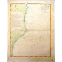
Chart of Russian Alaska showing cap Prince of Wales. In two sheets joined as one. Text written in Russian. This detailed large scale chart centers on the extreme north ea...
Date: Moscow, 1874
Selling price: ????
Please login to see price!
Sold in 2014
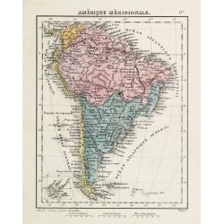
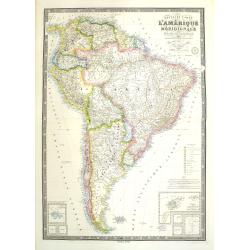
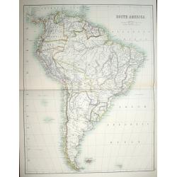
Amérique Méridionale.
Attractive 19th century map of the South American continent. Small inset of the Galapagos Islands in the lower left corner.
Date: Brussel, ca. 1875
Selling price: ????
Please login to see price!
Sold in 2011
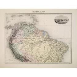
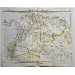
Amérique du Sud (Partie Septentrionale)
Map showing the northern part of South America, from the state of Panama as far as Bolivia and the Minas Gerais state in Brazil.It presents the Lesser Antilles on top as...
Date: Paris, 1875
Selling price: ????
Please login to see price!
Sold in 2008
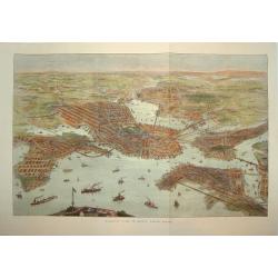
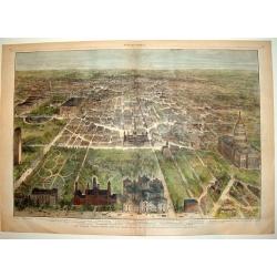
BIRDS-EYE VIEW OF BOSTON, UNITED STATES
A fabulous woodcut bird's-eye view of Boston and environs, drawn in the late 1860's or early 1870's. The work provides superb detail and identifies many important sites, ...
Date: Boston, ca. 1875
Selling price: ????
Please login to see price!
Sold
![Untited [Texas, Indian Territory, Kansas, Missouri, Arkansas, Louisiana]](/uploads/cache/23331-250x250.jpg)
Untited [Texas, Indian Territory, Kansas, Missouri, Arkansas, Louisiana]
Very detailed map prepared by A.Petermann, illustrating the South Central United States: Texas, Indian Territory, Kansas, Missouri, Arkansas, Louisiana. Great detail in T...
Date: Gotha 1875
Selling price: ????
Please login to see price!
Sold
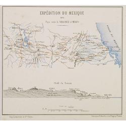
Expédition du Mexique. 1861 Pays entre la Vera Cruz et Mexico.
Map of Mexico centered on Mexico City until Vera Crux. In lower part a profile of the terrain. Showing in red the French expedition of 1861. Published in "Atlas de G...
Date: Paris, Furne, Jouvet et Cie, 1875
Selling price: ????
Please login to see price!
Sold in 2010
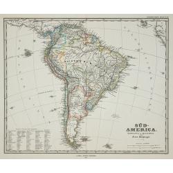
Süd-America.
Map of South-America, published in Stieler's Hand Atlas .
Date: Gotha, 1875
Selling price: ????
Please login to see price!
Sold in 2011
Nouvelle carte de l'Amérique Méridionale et des iles qui en dépendent Dédié à l'Academie Imp.le des Sciences de l'Institut de Franc. . . . 1876
Very large, highly detailed and scarce issue of the map of South America prepared by A. Vuillemin after Adrien Hubert Brué (1786-1832). The map has shipping lines added ...
Date: Paris, 1875
Selling price: ????
Please login to see price!
Sold in 2018
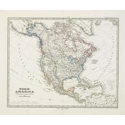
Nord-America. Entworfen u. gezeichnet von F. von Stülpnagel.
Large and detailed steel engraving showing North and Central America as well as the Caribbean.Published in Stieler's Hand Atlas.Texas named.
Date: Gotha, 1875
Selling price: ????
Please login to see price!
Sold in 2017
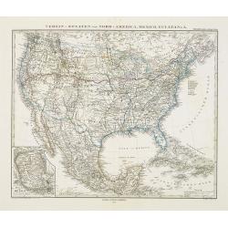
Verein-Staaten von Nord-America, Mexico, Yucatan..
Very detailed map of the United States of America showing the Caribbean. With an inset map of the surrounding area of Mexico city. Details of towns, forts, topo., railroa...
Date: Gotha, 1875
Selling price: ????
Please login to see price!
Sold in 2020
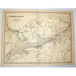
Dominion of Canada (Western Sheet).
Nice hand-colored lithographed map of the Dominion of Canada (Western Sheet). Engraved& printed by W & A.K. Johnston of Edinburgh. Published in London by William ...
Date: Edinburgh, 1875
Selling price: ????
Please login to see price!
Sold in 2014

Moonlight on the Mississippi. Vapeur du Mississippi. Clair de lune sur le Mississippi.
"Moonlight on the Mississippi" showing the Great Republic. A closeup of the famous steamboat said to be surpassed only in size, speed and luxury by the J. M. Wh...
Date: New York, ca. 1875
Selling price: ????
Please login to see price!
Sold in 2014
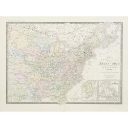
Carte de la region orientale des Éts-Unis et de la dominion du Canada.
Detailed map of The United States of America and Canada, with in lower right corner inset maps of Florida and Newfoundland.Prepared by A.Brué, re-edited by E.Levasseur a...
Date: Paris, 1876
Selling price: ????
Please login to see price!
Sold in 2020

Machinery Hall - International Exhibition Fairmount Park
Very fine depiction of Machinery Hal at the 1876 International World exhibition in Philadelphia. The building was 1402 feet wide and used 14 acres. The centennial exhibit...
Date: Philadelphia 1876
Selling price: ????
Please login to see price!
Sold in 2008

Argicultural Hall - International Exhibition Fairmount Park
A very fine depiction of Agricultural Hal at the 1876 International World exhibition in Philadelphia. The building was 826 feet wide and used 10.15 acres. The centennial ...
Date: Philadelphia, 1876
Selling price: ????
Please login to see price!
Sold in 2008

Main Building - International Exhibition Fairmount Park
Very fine depiction of Memorial Hal at the 1876 International World exhibition in Philadelphia. The building was 1880 feet wide and used 21.47 acres. The centennial exhib...
Date: Philadelphia 1876
Selling price: ????
Please login to see price!
Sold in 2008

Memorial Hall - International Exhibition Fairmount Park
Very fine depiction of Memorial Hal at the 1876 International World exhibition in Philadelphia. The building was 365 feet wide and used 1.5 acres. The centennial exhibiti...
Date: Philadelphia 1876
Selling price: ????
Please login to see price!
Sold in 2008

Horticultural Hall-International Exhibition Fairmount Park
Very fine depiction of Horticultural Hal at the 1876 International World exhibition in Philadelphia. The building was 360 feet wide and used 1.5 acres. The centennial exh...
Date: Philadelphia 1876
Selling price: ????
Please login to see price!
Sold in 2008

Bird's eye view, Centennial buildings.
Overview of the grounds of the 1876 International Exhibition Worldexpo in Philadelphia. The centennial exhibition took place to celibrate the 100 year eccistance of the R...
Date: Philadelphia 1876
Selling price: ????
Please login to see price!
Sold
Atlantique sud carte de la direction et de l'intensité propable des vents. . . Juillet, Aout, Septembre.
Map of the south of Atlantic Ocean. Showing South America and South Africa and the different wind directions for July, August, and September prepared by L.Brault.
Date: Paris, 1876
Selling price: ????
Please login to see price!
Sold in 2011
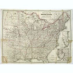
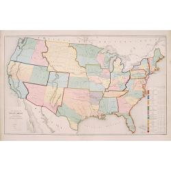
Travelers' Rail Road Map of the United States to Accompany ‘Boston to Washington' Riverside Series Centennial Guides. . .
Lithographed folding map with excellent original outline hand color for state boundaries. 28 1/4 x 38" at neat line. Sheet size: 30 x 39 1/4". Three inset maps ...
Date: New York, G. W. & C. B. Colton & Co., 1876
Selling price: ????
Please login to see price!
Sold in 2014
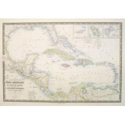
Carte générale des Iles Antilles, des iles et bancs de Bahama, des Etats-Unis . . .
Scarce and large (614 x 930 mm / 24.2 x 36.6 inches) map of the Caribbean, including the Gulf coast and central America, and insets of the Virgin Islands, Martinique and ...
Date: Paris, 1876
Selling price: ????
Please login to see price!
Sold in 2023
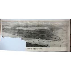
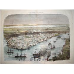
New York from Bergen Hill - Hoboken.
A large and detailed view of New York City issued in the year of America's centennial as an "extra supplement" to the Illustrated London News (Aug. 19, 1876).Fr...
Date: London, 1876
Selling price: ????
Please login to see price!
Sold in 2017
Carte Ecclésiastique des Etats Unis d'Amérique.
Uncommon map of the United States divided up in 11 missionary regions, including on the right side a list of the total population, Catholics, priests and the number of ch...
Date: Lyon/ Paris 1877
Selling price: ????
Please login to see price!
Sold

Álbum del ferrocarril mexicano : colección de vistas pintadas del natural por Casimiro Castro. Con una descripcion del camino y de las regiones que recorre por Antonio Garcia Cubas.
Album del Ferrocarril Mexicano - Album of the Mexican Railway: A Collection of Views Taken from Nature...With a Description of the Line and Country Through Which it Passe...
Date: Mexico, Victor Debray, 1877
Selling price: ????
Please login to see price!
Sold in 2011
![[The City of San Francisco.]](/uploads/cache/27529-250x250.jpg)
[The City of San Francisco.]
A very decorative bird's-eye view of San Francisco. The city is seen from above the harbor, which teems with sailing and steam vessels.Published by Currier & Ives 125...
Date: New York, 1877
Selling price: ????
Please login to see price!
Sold in 2014
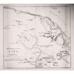
Battle plan of York.
A battle plan of York, from a Dutch translation of 'The life of George Washington'.
Date: Haarlem, 1877
Selling price: ????
Please login to see price!
Sold in 2019
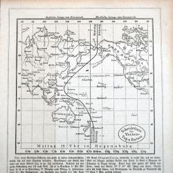
Scheidelinie für Wochen-Tag u. Datum
A rare German map of the date line in the Pacific. Shows the line running west of the Caroline Islands. Curiously the map still shows the phantom island 'Rica de Plata'! ...
Date: Regensburg, ca 1877
Selling price: ????
Please login to see price!
Sold in 2021
Carte générale du Golfe du Mexique d'après les traveaux Américans, Anglais et Français les plus récents. Publiée par ordre de L'Empereur..
Important chart of Texas, Florida and the Gulf Coast, heavenly leaning on the landmark map Carta Esferica. The original map was commissioned by the governor of Spanish Lo...
Date: Paris (1865) corrected for 1878
Selling price: ????
Please login to see price!
Sold
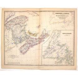
Dominion of Canada.
A fine map of the eastern part of Canada with a large insert of Newfoundland. Alexander Keith Johnston (1804 – 1871) was a Scottish geographer. After being apprentice...
Date: Edinburgh, 1878
Selling price: ????
Please login to see price!
Sold in 2013
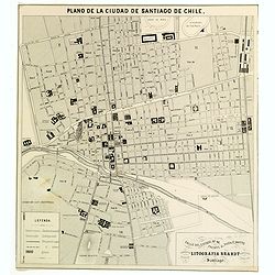
Plano de la Ciudad de Santiago de Chile.
A nice sized plan of the Chilean capital of Santiago towards the end of the nineteenth century. This orderly plan lays out the cities divisions and sub divisions, churche...
Date: Santiago, ca 1878
Selling price: ????
Please login to see price!
Sold in 2016
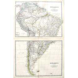
South America (Northern Sheet + Southern Sheet).
A large map on two sheets of all of South America. A small inset map shows the Galapagos Islands. Excellent maps with fantastic detail.
Date: Edinburgh, 1878
Selling price: ????
Please login to see price!
Sold in 2018
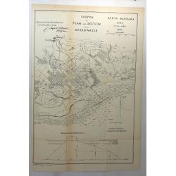
Sketch of Plan and Section of a Breakwater, San Buenaventura Cal. 1870
A scarce early map of Ventura, extending from the San Buenaventura River and the City of Ventura southward and showing the town, mountains several rivers and extensive so...
Date: Washington, 1878
Selling price: ????
Please login to see price!
Sold in 2018
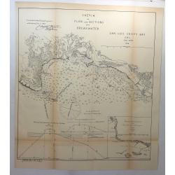
Sketch of Plan and Sections of a Breakwater, San Luis Obispo Bay, Cal. 1876.
A scarce early map of the San Luis Obispo area of California. It is one of the earliest obtainable plans of San Luis Obispo. Showing the town, mountains several rivers an...
Date: Washington, 1878
Selling price: ????
Please login to see price!
Sold in 2018
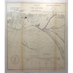
Sketch of Plan and Section of a Breakwater, San Buenaventura, Cal. 1870.
A scarce early map of Ventura, extending from the San Buenaventura River and the City of Ventura southward. Showing the town, mountains several rivers and extensive sound...
Date: Washington, 1878
Selling price: ????
Please login to see price!
Sold in 2018
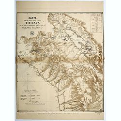
Carta de la Hoya del Lago Titicaca...Oceano Pacifico.
Map of the region surrounding Lake Titicaca in Peru. Map shows roads, railways, major, and minor towns, mineral mines, and the physical geography of the region. Map has a...
Date: Santiago, 1879
Selling price: ????
Please login to see price!
Sold in 2016
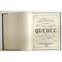
Atlas of the city and county of Quebec from actual surveys, based upon the cadastral plans deposited in the office of the Department of Crown Lands.
This scarce city atlas of Quebec is illustrated with 18 hand-colored maps made by Henry Whitmer, 1838-1920. The atlas contains 12 maps of Parishes, 5 maps of Quebec by ...
Date: Provincial Surveying and Pub. Co., Walter, S, MacCormac, manager,1879
Selling price: ????
Please login to see price!
Sold in 2023
Carte .. De la Patagonie et de la Terre de Feu..
Very detailed map of Strait of Magellan, prepared by J.Grange.Engraved by Jacobs. With a color key to soil conditions.
Date: Paris c.1880
Selling price: ????
Please login to see price!
Sold
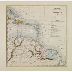
Carte des Colonies Françaises aux Antilles.
Uncommon map including Venezuela, French Guiana, Suriname, and the islands in the Caribbean. With a color key to the French, English, Spanish, Dutch and Danish possession...
Date: Paris, Abel Pilon & Co., c.1880
Selling price: ????
Please login to see price!
Sold in 2012
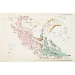
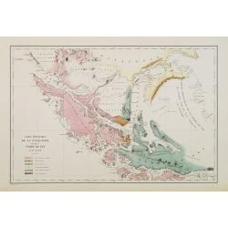
Carte géologique de la Patagonie et de la Terre de Feu.
Very detailed geological map of Strait of Magellan, prepared by J.Grange.Engraved by Jacobs. With a color key to soil conditions.From "Voyage au Pôle Sud et dans l'...
Date: Paris c.1880
Selling price: ????
Please login to see price!
Sold in 2010
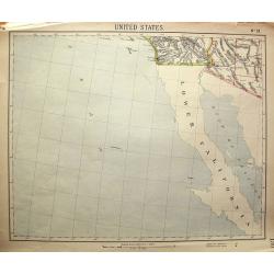
United States No. 19.
Unusual map, showing Baja California, and the area to San Diego, Santa Catalina Island, Yuma, Phoenix. Attractive map, with decorative coloring.
Date: London, c1880
Selling price: ????
Please login to see price!
Sold in 2011
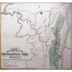
Map Issued by H.C. Frick & Co., Manufacturers Connellsville Coke.
Scarce large-scale map of the Connellsville coal vein by the H.C. Frick Coke Company. Locates ovens, towns, railroads, roads, creeks, etc. We could not locate a copy of ...
Date: Pittsburgh, 1880
Selling price: ????
Please login to see price!
Sold in 2013
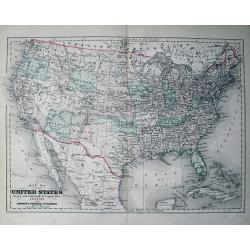
Map of the United States Drawn and Engraved on Copper-Plate Expressly for Johnson's Universal Cyclopaedia.
Fine map of the United States. Oklahoma is Indian Territory and only "one" Dakota. With many place names, railroads, etc.
Date: New York, c1880
Selling price: ????
Please login to see price!
Sold in 2013
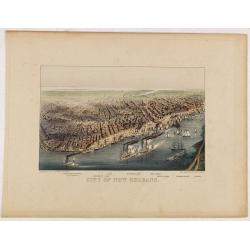
City of New Orleans.
A very decorative bird's-eye view of New Orleans with the Mississippi River in the foreground. Lake Pontchartrain is visible in the distance. Keyed below image : Lake Pon...
Date: New York, ca. 1880
Selling price: ????
Please login to see price!
Sold in 2014

The Steam-Ship Alaska.
A fine Currier & Ives chromolithographic print featuring the steam-ship Alaska of the Guion Line. Its nickname was "THE GREYHOUND OF THE ATLANTIC." This pri...
Date: New York, ca. 1880
Selling price: ????
Please login to see price!
Sold in 2016
Long Beach, Long Island. 1. Long Beach Hotel. 2. Bathing Pavilion. 3. Map Showing the route to Long Beach.
3 views on one sheet. Map depicts the city map of New York and the city with its surroundings.
Date: London, ca. 1880
Selling price: ????
Please login to see price!
Sold in 2018
![[Lot of 12 maps and prints relating to Surinam and South America and map of The Netherlands]](/uploads/cache/48306-250x250.jpg)
[Lot of 12 maps and prints relating to Surinam and South America and map of The Netherlands]
A lot of 12 maps and prints of Surinam, South America and one of the Netherlands. Including Bellin's maps of "Carte de l'Isle de Cayenne et de ses Environs (205x285m...
Date: Netherlands, Paris, ca. 1700-1880
Selling price: ????
Please login to see price!
Sold in 2022
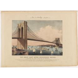
The Great East River Suspension Bridge. Pont de Brooklyn. Connecting the cities of New York and Brooklyn.
A very decorative print of the Brooklyn Bridge. The bridge enters the print at center left, the New York end of the bridge is at right, with lower Manhattan. Featured wit...
Date: New York, 1881
Selling price: ????
Please login to see price!
Sold in 2014
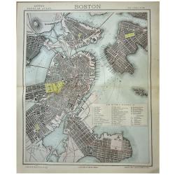
Boston.
A highly detailed late -19th century plan of the city of Boston. It depicts the entire city in remarkable detail, noting individual streets, important public buildings, r...
Date: London, 1881
Selling price: ????
Please login to see price!
Sold in 2020
Set of 6 maps South America.
A set of 6 highly detailed colored maps of the different countries that go to make up the whole of South America.Each map with a color key to British Consulates and Briti...
Date: London, 1881
Selling price: ????
Please login to see price!
Sold in 2020
OUR NATIONAL CAPITAL VIEWED FROM THE SOUTH
A handsome, hard to find, double page bird's-eye panorama of Washington D.C. as seen in the early 1880's. This finely engraved wood-cut provides excellent detail of the c...
Date: New York, 1882
Selling price: ????
Please login to see price!
Sold
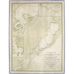
Carta das Lagoas dos Patos, Mirim e dos Canaes que as ligao a Barra do Rio Grande do Sul..
Large lithography illustrating the coastal area of the Brazilian state "Rio Grande do Sul", namely the 2 large lagoons Merin and dos Patos.With 3 inset maps sup...
Date: Rio de Janeiro, 1882
Selling price: ????
Please login to see price!
Sold in 2013
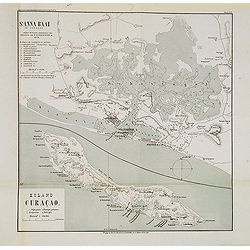
St. Anna Baai op Curaçao. / Eiland Curaçao.
Very detailed (1:20.000) lithographed map of St. Anna Bay, including Willemstad with the historic center of the city with Punda and Otrobanda. on the island Curaçao as s...
Date: Amsterdam-Utrecht, K.N.A.G./ C.L.Brinkman, J.J.Beijers, 1882
Selling price: ????
Please login to see price!
Sold in 2013
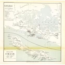
St. Anna Baai op Curaçao. / Eiland Curaçao.
Very detailed (1:20.000) lithographed map of St. Anna Bay, including Willemstad with the historic center of the city with Punda and Otrobanda. on the island Curaçao as s...
Date: Amsterdam-Utrecht, K.N.A.G./ C.L.Brinkman, J.J.Beijers, 1882
Selling price: ????
Please login to see price!
Sold in 2015
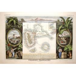
Colonies Francais en Amerique - Guadaloupe & St. Martin's.
Beautiful map of the Caribbean Islands of Guadeloupe and Grande Terre. The map is surrounded by several elaborate decorative engravings designed to illustrate the richnes...
Date: Paris, 1882
Selling price: ????
Please login to see price!
Sold in 2015
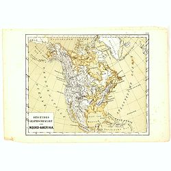
Oro-Hydrographische Kaart van Noord-Amerika.
One of the earliest thematic maps of North America published in the Netherlands from "Atlas der natuurkundige aardrijkskunde. . .". prepared by Nicolaas Wilhelm...
Date: Amsterdam, C.L. Brinkman, 1883
Selling price: ????
Please login to see price!
Sold in 2018
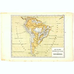
Oro-Hydrographische Kaart van Zuid-Amerika.
One of the earliest thematic maps of South America published in the Netherlands from "Atlas der natuurkundige aardrijkskunde. . .". prepared by Nicolaas Wilhelm...
Date: Amsterdam, C.L. Brinkman, 1883
Selling price: ????
Please login to see price!
Sold in 2020
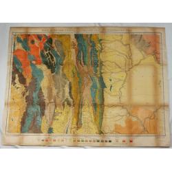
Parts of Western Wyoming, Southeastern Idaho and Northeastern Utah.
A fine, detailed economic map of portions of the mid-western states of Wyoming, Idaho and Utah, published in 1883 in Hayden's 12th Annual Report. It is a spectacular, ear...
Date: Washington, 1883
Selling price: ????
Please login to see price!
Sold in 2018
PANORAMIC VIEW OF NEW ORLEANS - THE FEDERAL FLEET AT ANCHOR IN THE RIVER, APRIL 25TH, 1862
A superb bird's-eye panoramic view of the city of New Orleans in April, 1862. From a special 1884 publication titled: "The Soldier in our Civil War an Illustrated H...
Date: New York, 1884
Selling price: ????
Please login to see price!
Sold
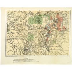
Map showing private land claims, patented or unpatented or cinfirmed in New Mexico, Colorado and Arizona.
Rare map showing private land claims, patented or unpatented or confirmed in New Mexico, Colorado and Arizona to accompany Thomas Donaldson "The Public Domain, Its H...
Date: Washington, 1884
Selling price: ????
Please login to see price!
Sold in 2012
Carte Particuliere de la Cote du Bresil.
Large detailed map of the coast of Brazil from The Bay of Sapetiba to the Island of Sao Sebastia. It was priced at two francs when produced. Depot de la Marine (1720 - ...
Date: Paris, 1884
Selling price: ????
Please login to see price!
Sold in 2013
A collection of 5 maps North and South America, Canada.
A collection of 5 maps North and South America, Canada by W. & A.K. Johnston and published by W & R Chambers, of London & Edinburgh.The map of Canada, South A...
Date: London, 1885
Selling price: ????
Please login to see price!
Sold in 2012
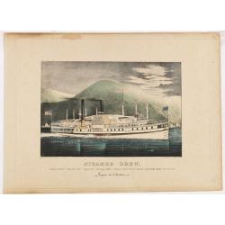
Steamer Drew. Vapeur de l'Hudson.
A very decorative print of the steamboat "Drew" sailing on the Hudson River.Published by Currier & Ives 125 Nassau Street, New York."Currier & Ives...
Date: New York, ca. 1885
Selling price: ????
Please login to see price!
Sold in 2014
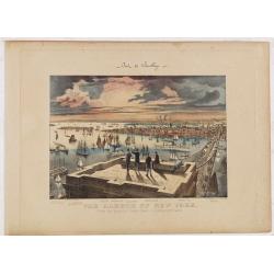
The Harbor of New York. Pont de Brooklyn.
A very decorative print of New York Harbor and Brooklyn Bridge. Five men stand or sit on the Brooklyn Bridge tower in the foreground. The harbor extends to the horizon at...
Date: New York, ca. 1885
Selling price: ????
Please login to see price!
Sold in 2014
Atlas pintoresco e histórico de los Estados Unidos Mexicanos.
Monumental atlas solely devoted to Mexico, very rare to find complete and in very good condition.This atlas is regarded as one of the most beautiful color-plate books on ...
Date: Mexico City, sucesores de Debray, 1885
Selling price: ????
Please login to see price!
Sold
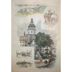
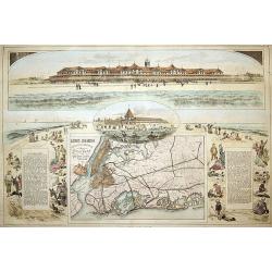
Annapolis, Maryland
A beautiful woodcut grouping incorporating five views of / in Annapolis, the capital of Maryland. The central view is of the old capitol building. The original U.S. Naval...
Date: New York, 1886
Selling price: ????
Please login to see price!
Sold
Carte des rcifs Arbrohos (Cote du Bresil).
Large detailed marine chart of the coast of Brazil from San Mateo to the Itacolomis. The cost of the chart was printed on the map and was two francs. Depot de la Marine...
Date: Paris, 1887
Selling price: ????
Please login to see price!
Sold in 2015
ILE UVEA CROQUIS DES BAIES DE MUA ET DE MATA UTU.
Mata-Utu is the capital of Wallis and Futuna, an overseas collectivity of France. It is located on the island of Uvéa, in the district of Hahake, of which it is also the...
Date: Paris, 1887
Selling price: ????
Please login to see price!
Sold in 2018
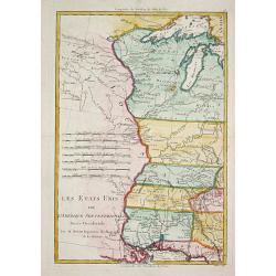
Les Etats Unis de l' Amerique Septentrionale, Partie Occidentale.
Rigobert Bonne (1727-1795), French cartographer. His maps are found in a.o. Atlas Moderne (1762), Raynal's Histoire Philos. du Commerce des Indes (1774) and Atlas Encyclo...
Date: Paris, 1787-1888
Selling price: ????
Please login to see price!
Sold
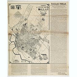
Murphy Bolanz. Official Map of the City of Dallas and East Dallas, Texas, 1887.
Engraved map with to the right and lower margin. Very small inset map of northeast Texas at top, along with an illustration of the firm's offices. Size of the map 375x252...
Date: Dallas, June, 1888
Selling price: ????
Please login to see price!
Sold in 2014
(A set of six maps of Central & South America)
This beautiful set of maps were made by Adam and Charles Black in 1889 for the library edition of "The Scribner-Black Atlas of the World" And also for "Bla...
Date: Edinburgh, 1889
Selling price: ????
Please login to see price!
Sold in 2014

Eight volumes, ' Narrative and Critical History of America ' by Justin Winsor, complete, published by Houghton, Mifflin & Co. Boston at the Riverside Press 1889
In addition to the set in volume, I is a handwritten letter dated July 7th, 1893, signed Edward Channing, an American historian, and author of a monumental "History ...
Date: Boston, 1889
Selling price: ????
Please login to see price!
Sold in 2017

ATLAS TO ACCOMPANY THE OFFICIAL RECORDS OF THE UNION AND CONFEDERATE ARMIES 1861 - 1865
A highly desirable, rarely found double page lithograph of official Union and Confederate army uniforms, along with chevrons, buttons, badges, caps and more. A fascinatin...
Date: New York, c. 1890
Selling price: ????
Please login to see price!
Sold
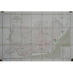
Plano de la Ciudad de Buenos-Aires.
Folding plan of Buenos Aires orientated with north towards the right edge, scale c. 1½ inches to 1 kilometre. Original color to water and parks, street names printed in ...
Date: (Offered by the Pintureria of Monserrat, Buenos Aires). 1890
Selling price: ????
Please login to see price!
Sold in 2012
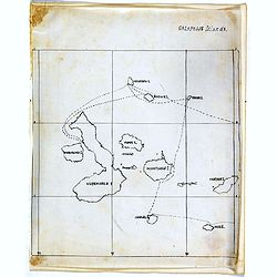
Galapagos Islands.
An unusual small, and basic manuscript map of the Galapagos Islands in the Pacific Ocean, off the coast of South America. It looks as though the map depicts an explorers ...
Date: London, ca. 1890
Selling price: ????
Please login to see price!
Sold in 2017
![[Untitled Turkish map of Central America, from California until Honduras]](/uploads/cache/81325-250x250.jpg)
[Untitled Turkish map of Central America, from California until Honduras]
An unusual Turkish map of Central America, from California until Honduras, including parts of today's Arizona, New Mexico, Texas and Louisiana. A highly collectible Ottom...
Date: Turkey, ca. 1890
Selling price: ????
Please login to see price!
Sold in 2018
![Canada Creek Falls . . [title in French, English, German & Latin] N°32. Pl. 4.](/uploads/cache/26800-250x250.jpg)
Canada Creek Falls . . [title in French, English, German & Latin] N°32. Pl. 4.
A view of the Canada Creek Falls.From 8e Livraison Amérique Septentrionale - Etat de New York. After Jacques Milbert and lithographed by Dupressoir and figures by V. Ada...
Date: Paris, Bove dirigée par Nöel ainé & Cie, 1892
![Albany-Capital of the State of New York. . . [title in French, English, German & Latin] N°13. Pl. 1.](/uploads/cache/26654-250x250.jpg)
Albany-Capital of the State of New York. . . [title in French, English, German & Latin] N°13. Pl. 1.
A town-view coastal of Albany-Capital of the State of New York..From 4e Livraison Amérique Septentrionale - Etat de New York. After Jacques Milbert and lithographed by D...
Date: Paris, Bove dirigée par Nöel ainé & Cie, 1892
Selling price: ????
Please login to see price!
Sold in 2010
![Foundery on Jone's Creek near Baltimore. . [title in French, English, German & Latin] N°52. Pl. 4.](/uploads/cache/26804-250x250.jpg)
Foundery on Jone's Creek near Baltimore. . [title in French, English, German & Latin] N°52. Pl. 4.
A view of Jone's Creek foundery near Baltimore.From 13e Livraison Amérique Septentrionale - Etat de New York. After Jacques Milbert and lithographed by Bichebois and fig...
Date: Paris, Bove dirigée par Nöel ainé & Cie, 1892
Selling price: ????
Please login to see price!
Sold in 2009
![Commencement of Passaic falls. . [title in French, English, German & Latin] N°47. Pl. 3.](/uploads/cache/26818-250x250.jpg)
Commencement of Passaic falls. . [title in French, English, German & Latin] N°47. Pl. 3.
A view of the Passaic Falls.From 12e Livraison Amérique Septentrionale - Etat de New York. Drawn after nature by J.R.Smith and lithographed by Dupressoir and the figures...
Date: Paris, Bove dirigée par Nöel ainé & Cie, 1892
Selling price: ????
Please login to see price!
Sold in 2009