Browse Listings in America
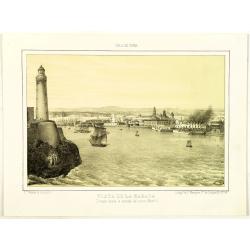
Habana. 2a Vista tomada desde Casa-Blanca.
Decorative view of Havana harbor, by Frederico Mialhe (1810-1881), with his signature on stone lower right. Lithographed by L. Marquier Ce de Lamparillo No. 96. From the ...
Date: Havana, 1838
Selling price: ????
Please login to see price!
Sold in 2010
Habana. 2a Vista tomada desde Casa-Blanca.
Decorative view of Havana harbor, by Frederico Mialhe (1810-1881), with his signature on stone lower right. Lithographed by L. Marquier Ce de Lamparillo No. 96. From the ...
Date: Havana, 1838
Selling price: ????
Please login to see price!
Sold in 2010
Habana. 2a Vista tomada desde Casa-Blanca.
Decorative view of Havana harbor, by Frederico Mialhe (1810-1881), with his signature on stone lower right. Lithographed by L. Marquier Ce de Lamparillo No. 96. From the ...
Date: Havana, 1838
Selling price: ????
Please login to see price!
Sold in 2010
Habana. 2a Vista tomada desde Casa-Blanca.
Decorative view of Havana harbor, by Frederico Mialhe (1810-1881), with his signature on stone lower right. Lithographed by L. Marquier Ce de Lamparillo No. 96. From the ...
Date: Havana, 1838
Selling price: ????
Please login to see price!
Sold in 2010

3 Portraits of Christopher Columbus, Queen Isabella and King Ferdinand.
Three hand-colored, steel engravings of the three individuals responsible for discovering America - Christopher Columbus and his investment bankers, Isabella and Ferdinan...
Date: London, 1838
Selling price: ????
Please login to see price!
Sold in 2013
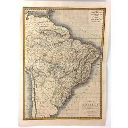
Carte du Bresil
A fine, detailed map of Brazil from Columbia to the Atlantic Ocean. The map also includes parts of the neighbouring countries of Chile, Peru and the Caribbean. Engraved b...
Date: Paris, 1838
Selling price: ????
Please login to see price!
Sold in 2016
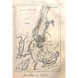
Plan der Bai von New=York.
Unusual map of early New York City. Only southern Manhattan is shown populated, with a few buildings in Brooklyn. Long Island and Staten Island appear almost uninhabited....
Date: Stuttgart, 1838
Selling price: ????
Please login to see price!
Sold in 2017
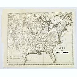
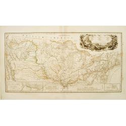
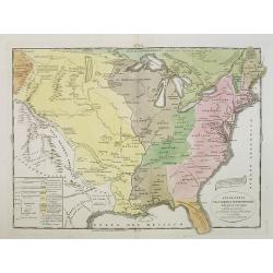
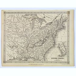
Map of the United States.
General map of the United States, dated around 1838 and shows Texas. Some place names, but mostly rivers and tributaries, lakes, territories mountains and some Indian tri...
Date: America, 1838
Selling price: ????
Please login to see price!
Sold in 2017
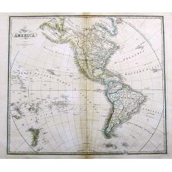
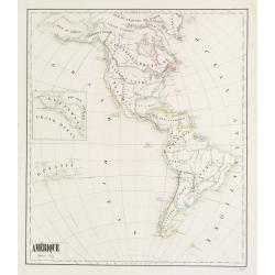
Map of America.
A large map of the Americas and the Pacific. With many interesting details, such as Russian Possessions in Alaska. Mexico seems to extend well into today's California, Ar...
Date: London, 1838
Selling price: ????
Please login to see price!
Sold in 2017
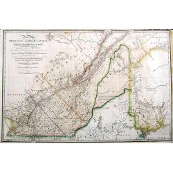
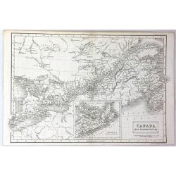
A New Map of the province of Lower Canada, describing all the Signeuries, Townships, Grants of Land, &c. . .
A large and important map of lower Canada, illustrating the land grants on either side of the St. Lawrence River. The disputed boundary line with the United States (with ...
Date: London, 1838
Selling price: ????
Please login to see price!
Sold in 2017
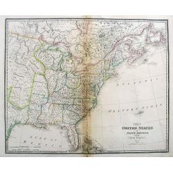
The United States of North America, with the British Territories.
A highly detailed map of the United States, extending from Missouri and Texas to New Found Land and the Bahamas.With some early names of regions, and several interesting ...
Date: London, 1838
Selling price: ????
Please login to see price!
Sold in 2017
Carte de l'Amerique Septentrionale.
French map of North America showing Oregon Territory extending north into British Columbia in Canada, Missouri Territory extends from the shores of Lake Michigan across t...
Date: Paris, 1838
Selling price: ????
Please login to see price!
Sold in 2017
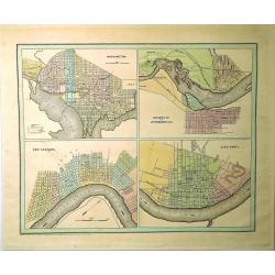
Washington, Louisville & Jefferson, New Orleans & Cincinnati.
Four city maps in full color. The map of Washington includes numbered locations including the Capitol, the State Department, Departments of War, Navy, and the Treasury, a...
Date: New York, 1838
Selling price: ????
Please login to see price!
Sold in 2019
Carte itinéraire du Prince Maximilien..
Engraved map of the interior of the Northern U.S., from Atlantic seaboard to the Rocky Mountains with outline coloring indicating the route of travels and Indian nations....
Date: Paris, Coblenz, or London, 1839
Selling price: ????
Please login to see price!
Sold

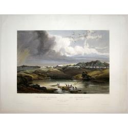
Cutoff-River - Branch of the Wabash.
Original aquatint engraving for Travels in the Interior of North America between 1832-34 . Engraved by L.Weber. The finest work on American Indian life and the American F...
Date: London / Paris / Coblenz, 1839
Selling price: ????
Please login to see price!
Sold in 2009

Cave in Rock- view on the Ohio.
Original aquatint engraving for Travels in the Interior of North America between 1832-34 . Engraved by Lucas Weber. The finest work on American Indian life and the Americ...
Date: London/Paris/Coblenz, 1839
Selling price: ????
Please login to see price!
Sold in 2020
Amérique - Fevrier 1839
Fine manuscript map of America with relief shown pictorially. The Oceans in wash color and the borders in different colors. Dated 1839 and signed by the author ShuardLowe...
Date: Paris, 1839
Selling price: ????
Please login to see price!
Sold in 2016
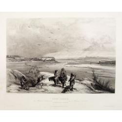
Fort Clark on the Missouri (February 1834)
Original aquatint engraving for Travels in the Interior of North America between 1832-34 . Engraved by Lucas Weber. The finest work on American Indian life and the Americ...
Date: London/Paris/Coblenz, 1839
Selling price: ????
Please login to see price!
Sold
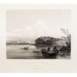
Mih-Tutta-Hangkusch a Mandan Village.
Original aquatint engraving for Travels in the Interior of North America between 1832-34 . Engraved by Lucas Weber. The finest work on American Indian life and the Americ...
Date: London/Paris/Coblenz, 1839
Selling price: ????
Please login to see price!
Sold
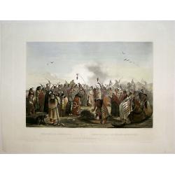
Scalp Dance of the Minatarris/ Scalptanz der Moennitarris/ Danse du Scalp des Indiens Meunitarris.
Print from: 'Reise in das innere Nord-America in den Jahren 1832 - 1834' by Prince Maximilian of Wied-Neuwied, after paintings by Karl Bodmer, engraved by Ch. Vogel, prin...
Date: London, 1839
Selling price: ????
Please login to see price!
Sold in 2015
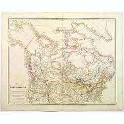
British North America.
A beautiful, large scale map of Canada, and the northern most states of America. Dedicated to the Hon. Hudsons Bay Company. It clearly shows the vastness of this fascinat...
Date: London, 1839
Selling price: ????
Please login to see price!
Sold in 2020
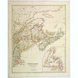
Lower Canada, New Brunswick, Nova Scotia, Prince Edward Island. . .
The prefix "lower" in its name refers to its geographic position farther downriver from the headwaters of the St. Lawrence River than its contemporary Upper Can...
Date: London, 1839
Selling price: ????
Please login to see price!
Sold in 2020
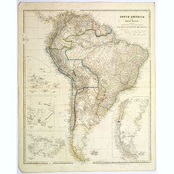
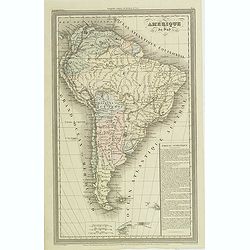
South America.
A striking steel engraved map of South America, with large, uncolored inset maps of The Galapagos Islands, Port San Carlos, Falkland Islands, and Patagonia. A tremendous ...
Date: London, 1839
Selling price: ????
Please login to see price!
Sold in 2017
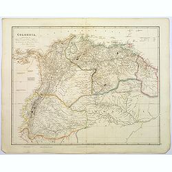
Colombia.
A large, detailed steel engraved map of the South American state of Colombia. This map of Colombia extends into modern day Venezuela to the east, and Ecuador to the south...
Date: London, 1839
Selling price: ????
Please login to see price!
Sold in 2020
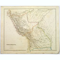
Peru & Bolivia.
A large, detailed steel engraved map of the South American states of Peru & Bolivia. Peru gained its independence from Spain in 1821. Bolivia was named after Simon Bo...
Date: London, 1839
Selling price: ????
Please login to see price!
Sold in 2017
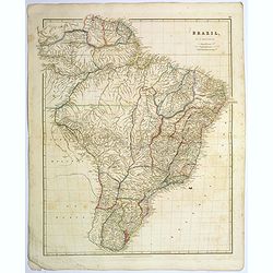
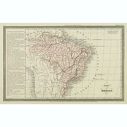
Brazil.
A large, detailed steel engraved map of the vast South American state of Brazil. The only Portuguese speaking colony in The Americas. It is the largest state in Latin and...
Date: London, 1839
Selling price: ????
Please login to see price!
Sold in 2017
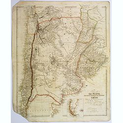
The Provinces of La Plata...and Chile.
A large, detailed steel engraved map of Chile and Argentina, together with Uruguay. Small inset map of Patagonia and Falkland Islands. Despite some map loss, the map is w...
Date: London, 1839
Selling price: ????
Please login to see price!
Sold in 2017
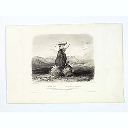
Magic Pile erected by the Assiniboin Indians.
This evocative and deeply spiritual engraving by Bodmer shows a cairn (human made stack, or pile of stones, rocks) topped with the skull of a buffalo, made by the Assinib...
Date: Pars, Coblenz, London, 1839
Selling price: ????
Please login to see price!
Sold in 2017
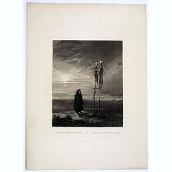
Offrande des Indiens Mandans.
This bleak, evocative and deeply spiritual engraving by Bodmer shows a Mandan skull shrine in 1833, located near the burial ground of Mih-Tutta-Hang-Kusch.Titles in Germa...
Date: Pars, Coblenz, London, 1839
Selling price: ????
Please login to see price!
Sold
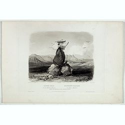
Magic Pile erected by the Assiniboin Indians.
This evocative and deeply spiritual engraving by Bodmer shows a cairn (human made stack, or pile of stones, rocks) topped with the skull of a buffalo, made by the Assinib...
Date: Pars, Coblenz, London, 1839
Selling price: ????
Please login to see price!
Sold in 2019
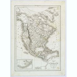
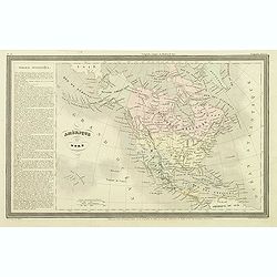
Map of North America. . .
An uncommon schoolboy map of North America, showing TX as a republic, and Alaska as "Russian Possessions." Mexico still extends well into today's California and...
Date: Hartford, ca 1839
Selling price: ????
Please login to see price!
Sold in 2018
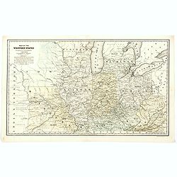
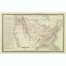
Map of the Western States designed to accompany Smith's Geography for Schools.
A detailed map of the American Midwest, published before the formation of Minnesota. It depicts individual counties, towns, roads, rivers, mountains, etc. Worth noting is...
Date: Chicago, 1839
Selling price: ????
Please login to see price!
Sold in 2020
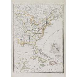
États Unis et Grandes Antilles.
America's east coast, the Great Lakes, Florida and the Caribbean.
Date: Paris, 1840
Selling price: ????
Please login to see price!
Sold in 2017
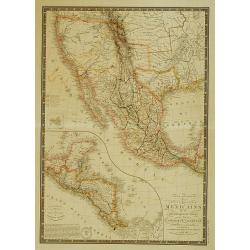
Carte générale des États-Unis Mexicains, de la République du Texas..
Map of Texas, Mexico and the South-West. Rare mention of the Republic of Texas in the title.Excellent pre-Fremont cartography in Upper or New California, although the 3 r...
Date: Paris 1840
Selling price: ????
Please login to see price!
Sold
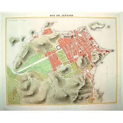
Rio de Janeiro
A handsome, seldom seen early 19th century plan of Rio de Janeiro and its famous bay. The map identifies the city's major thoroughfares, expanses and important points of ...
Date: Paris, ca. 1840
Selling price: ????
Please login to see price!
Sold in 2008
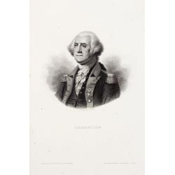
Washington.
Steel engraved portrait of Georges Washington, engraved by Ballin. Published by Dufour, Mulat et Boulanger Imp. Gilquin et Dupain, r. de la Calandre, 19, Paris.
Date: Paris ca 1840
Selling price: ????
Please login to see price!
Sold
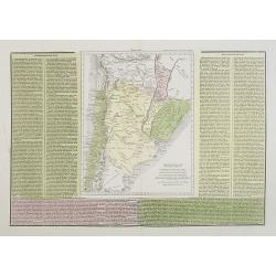
Confederazione del Chili, Stati Uniti Sulrio Plata, dittatorato del Paraguai, Repubblica Orientale dell'Urugai.
A rare and detailed double-page map of Chili, Paraguay and Uruguay. The map is surrounded by an explanatory historical text about the countries in green, yellow and pink ...
Date: Venice, 1840
Selling price: ????
Please login to see price!
Sold in 2019
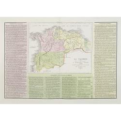
La Colombia . . .
A rare and detailed double-page map of Colombia, Bolivia and Venezuela. The map is surrounded by an explanatory historical text about the countries in pink, yellow and gr...
Date: Venice, 1840
Selling price: ????
Please login to see price!
Sold in 2011
Stati-Uniti Dell'America settentrionale . . .
A rare and detailed double-page map of eastern part of the United States of America, including Great Lakes, Florida, engraved by G.V.Pasquali. According to the title cart...
Date: Venice, 1840
Selling price: ????
Please login to see price!
Sold in 2016
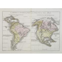
L'America Storica, Fisica e Politica nel 1825.
A rare and detailed double-page map of North and South America. From l'Atlante Storico, Letterario, Biografico, Archeologico. . . with attributions by Giambatista Albriz...
Date: Venice, 1840
Selling price: ????
Please login to see price!
Sold in 2014

America Settentrionale disegnata dopi i viaggi di Lewis, Clarke, Parry e Franklin. . .
A rare and detailed double-page map of eastern part of the United States of America, including Great Lakes, Florida, engraved by G.V.Pasquali.According to the title carto...
Date: Venice, 1840
Selling price: ????
Please login to see price!
Sold in 2018
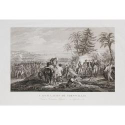
Capitulation de Cornwallis. Washington, Rochambeau, Lafayette - 19 Septembre 1781.
The plate, engraved by Delignon, shows a full-lentg figure of Washington in uniform, in company with Lafayette, Rochambeau and his officers, in the act of receiving the s...
Date: Paris, c.1840
Selling price: ????
Please login to see price!
Sold in 2009
Amerique du nord.
The map depicts the short lived "Republic of Fredonia," a reference to the Fredonia Rebellion, the first attempt to create a separate independent Republic in Te...
Date: Paris, Jules Renouard, ca.1840
Selling price: ????
Please login to see price!
Sold in 2012
Etats-Unis.
Finely engraved map prepared by A.H.Dufour and engraved by Giraldon-Bovinet, shortly before Texas became part of the United States. After gaining independence from Spain ...
Date: Paris, Jules Renouard, ca.1840
Selling price: ????
Please login to see price!
Sold in 2012
Amerique du sud.
Finely engraved map of South America, prepared by A.H.Dufour and engraved by Giraldon-Bovinet. Published by Jules Renouard in his uncommon atlas "Le globe Atlas clas...
Date: Paris, Jules Renouard, ca.1840
Selling price: ????
Please login to see price!
Sold
Empire du Brésil.
Finely engraved map prepared by A.H.Dufour and engraved by Giraldon-Bovinet. Published by Jules Renouard in his uncommon atlas "Le globe Atlas classique Universel de...
Date: Paris, Jules Renouard, ca.1840
Selling price: ????
Please login to see price!
Sold in 2012
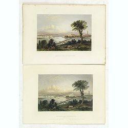
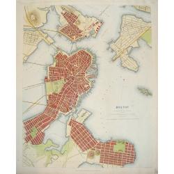
Boston, and Bunker Hill.
Two views of Boston and Bunker Hill. The artist was W. H. Bartlett (1809-1854), the English landscape painter who traveled widely in his short life, producing images of l...
Date: London, George Virtue, 1840
Selling price: ????
Please login to see price!
Sold in 2013
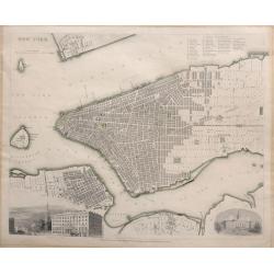
NEW YORK.
A detailed mid-19th century plan of the City of New York including Manhattan, Brooklyn, Governor's Island with parts of Jersey City and Williamsburg which was published u...
Date: London, 1840
Selling price: ????
Please login to see price!
Sold in 2016
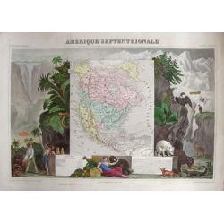
Amérique Septentrionale.
Very attractive map of America. To the left we find traders negotiating home-made products and a Maya pyramid. To the right we find plants and animals that are common for...
Date: Paris, 1840
Selling price: ????
Please login to see price!
Sold in 2014
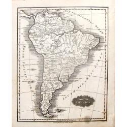
South America.
Pleasing map featuring "South America". Engraved by G. Boynton and published in Boston by Samuel Walker in about 1840.
Date: Boston, c1840
Selling price: ????
Please login to see price!
Sold in 2014
Le Due Repubbliche cioe La Confederazione Peruvian et Bolivia.
A rare, detailed map of Peru and Bolivia. The map is surrounded by explanatory historical text. Tasso's map was prepared by J.A. Buchon and A de la Sage for "L'ATLAN...
Date: Venice, 1840
Selling price: ????
Please login to see price!
Sold in 2017
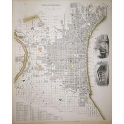
Philadelphia SDUK
A highly detailed mid-19th century plan of the city of Philadelphia by the Society for the Diffusion of Useful Knowledge.It depicts the entire city in remarkable detail, ...
Date: London, 1840
Selling price: ????
Please login to see price!
Sold in 2018
The White Castles on the Upper Missouri/ Die Weissen Schloesser am oberen Missouri/ Les Chateaux Blancs Missouri superior.
Aquatint from: 'Reise in das innere Nord-America in den Jahren 1832 - 1834' by Prince Maximilian of Wied-Neuwied, after paintings by Karl Bodmer, engraved by Himely, prin...
Date: London, 1840
Selling price: ????
Please login to see price!
Sold in 2015
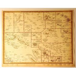
Polynesia or Islands in the Pacific Ocean.
A 1840 S.D.U.K. map of the islands of the Pacific Ocean or Polynesia. It has a total of 19 miniature maps on one sheet covering the Mariana Islands, the Pelew Islands, G...
Date: Chicago, 1840
Selling price: ????
Please login to see price!
Sold in 2018
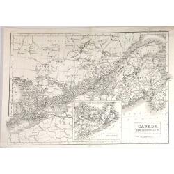
Canada, New Brunswick & c.
Fine map of Maritime part of Canada from Adam & Black's "General Atlas" published in Edinburgh in 1840.It includes Upper (Ontario) & Lower (Quebec) Cana...
Date: Edinbugh. 1840
Selling price: ????
Please login to see price!
Sold in 2015
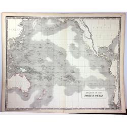
Islands of the Pacific Ocean
A detailed map of the Pacific Ocean that identifies hundreds of islands. The map includes Australia, North America, and parts of Asia and South America. Detail is confine...
Date: Edinburgh, 1840
Selling price: ????
Please login to see price!
Sold in 2016
Canada, New Brunswick & c.
A fine example of Adam and Charles Black's map of Canada. It covers from Malden to Cape Breton Island in Nova Scotia. The continuation of Nova Scotia is included in an in...
Date: Edinburgh, 1840
Selling price: ????
Please login to see price!
Sold in 2016
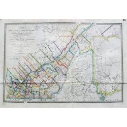
Quebec or Province of Lower Canada, Describing all the Seigneuries, Townships, Grants of Land, &c...
A large and important map of lower Canada, by or after Wyld, illustrating the land grants on either side of the St. Lawrence River. The boundary line of the United States...
Date: London, ca 1840
Selling price: ????
Please login to see price!
Sold in 2017
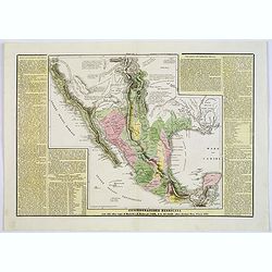
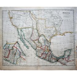
Confederazione Messicana . . .
A rare and detailed double-page map of Mexico. Map is surrounded by an explanatory historical text about the regions in a yellow background color.According to the title c...
Date: Venice, 1840
Selling price: ????
Please login to see price!
Sold in 2018
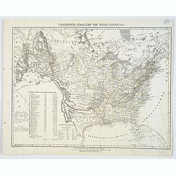
Vereinigte Staaten von Nord-America.
This handsome German map highlights the United States and her Territories, as numbered and outlined in yellow. The Republic of Texas (an independent nation until joining ...
Date: Glogau, ca 1840
Selling price: ????
Please login to see price!
Sold in 2020
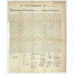
In congress, July 4, 1776. The unanimous declaration of the thirteen united Styates of America.
Scarce French reproduction based on William J. Stone’s official copperplate facsimile done by order of Congress. This French edition of the Declaration of Independance ...
Date: Paris, Kaeppelin & Cie, 1840
Selling price: ????
Please login to see price!
Sold in 2019
Eastern Division of the United States.
A fine chromolithograph map of the Eastern United States and parts of Canada. The Sioux, Fox, Chippewa and Algonquin Indian tribes are all mentioned. The capital of Arkan...
Date: London, 1840
Selling price: ????
Please login to see price!
Sold in 2021
Mexico and Guatemala, Shewing the position of the Mines.
A large map of Central America extending from the southern half of Mexico to Panama, and including the Grand Cayman and Jamaica. This is the separate Central American map...
Date: London, 1841
Selling price: ????
Please login to see price!
Sold in 2016
Venezuela, New Granada, Ecuador and the Guayanas
A map of the northern countries of South America including Venezuela, New Granada, Ecuador and The Guayanas.With four decorative vignettes showing Paramaribo, Fall of Bag...
Date: London, 1841
Selling price: ????
Please login to see price!
Sold in 2018
United States.
This detailed map of the United States that extends to show the eastern part of the Republic of Texas and a vast, and as yet unnamed western territory to the northwest of...
Date: London, 1841
Selling price: ????
Please login to see price!
Sold in 2019
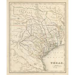
Texas
This is an important map of Texas during its time as a republic, showing the region as divided into land grants based on empresarios established by the Mexican government...
Date: Boston, 1841
Selling price: ????
Please login to see price!
Sold in 2023
BOSTON WITH CHARLESTOWN AND ROXBURY
A scarce, finely rendered early-to-mid 19th century English plan of the city of Boston, Massachusetts. The map includes the neighboring town of Charlestown. There is subs...
Date: London, dated 1842
Selling price: ????
Please login to see price!
Sold in 2009
Mexico. By J. Arrowsmith. Mexico, Shewing the connection with the Ports of Acapulco, Vera Cruz, & Tampico; on double the scale of the Map.
This map of Mexico, published by J. Arrowsmith in 1842, brings, below the lower neat line at center: "London, Pubd. 15 Feby. 1842, by J. Arrowsmith, 10 Soho Square&q...
Date: London, 1842
Selling price: ????
Please login to see price!
Sold in 2018
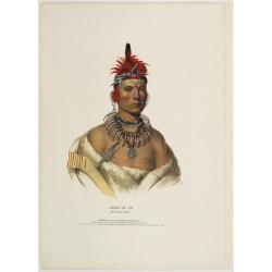
Chono Ca Pe an Ottoe chief.
A beautifully defined lithograph of Ottoe Indian Chief Chono Ca Pe from McKenney & Hall?s History of the Indian Tribes, perhaps the most important work ever published...
Date: Philadelphia, circa 1836-1842
Selling price: ????
Please login to see price!
Sold
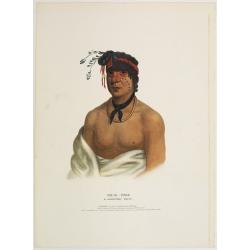
Wesh-Cubb a Chippway chief.
A beautifully defined lithograph of Chippway chief Wesh-Cubb from McKenney & Hall?s History of the Indian Tribes, perhaps the most important work ever published on No...
Date: Philadelphia, circa 1836-1842
Selling price: ????
Please login to see price!
Sold
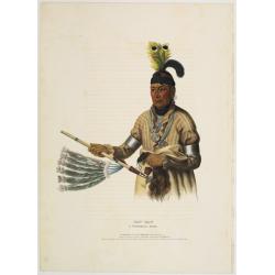
Naw-Kaw a Winnebago chief.
A beautifully defined lithograph of Winnebago chief Naw-Kaw, wearing a striped shirt, three peace medals around his neck, holding a peace pipe in one hand, what looks lik...
Date: Philadelphia, circa 1836-1842
Selling price: ????
Please login to see price!
Sold
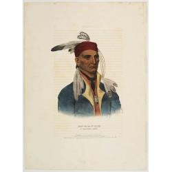
Shin-Ga-Ba-W'Ossin a Chippeway chief.
A beautifully defined lithograph of Chippeway chief Shin-Ga-Ba-W'Ossin from McKenney & Hall?s History of the Indian Tribes, perhaps the most important work ever publi...
Date: Philadelphia, circa 1836-1842
Selling price: ????
Please login to see price!
Sold

Se-Quo-Yah.
A beautifully defined lithograph of Se-Quo-Yah, or George Guess, the son of a white man and an Indian woman of mixed blood, recognized to this day for his creation of an ...
Date: Philadelphia, circa 1836-1842
Selling price: ????
Please login to see price!
Sold

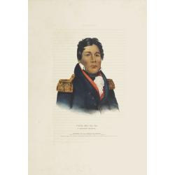
Qua-Ta-Wa-Pea a Shawanoe chief.
A beautifully defined lithograph of Shawanoe chief who is wearing a Jefferson peace medal. From McKenney & Hall?s History of the Indian Tribes, perhaps the most impor...
Date: Philadelphia, circa 1836-1842
Selling price: ????
Please login to see price!
Sold

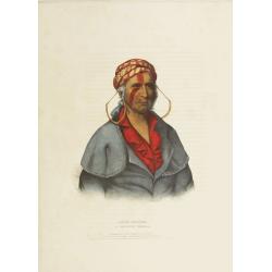
Mo-Hon-Go an Osage woman.
This hand-colored lithograph of Mo-Hon-Go, one of only eight women whose portraits appeared in this book. By contrast there were 111 men's portraits in it. Mo-hon-go, fl....
Date: Philadelphia, circa 1836-1842
Selling price: ????
Please login to see price!
Sold in 2008
Little-Crow a Sioux Chief.
This hand-colored lithograph of Little-Crow a Sioux Chief. Chief Little Crow was the eldest son of Cetanwakuwa (Charging Hawk). It was on account of his father's name, mi...
Date: Philadelphia, circa 1836-1842
Selling price: ????
Please login to see price!
Sold
Payta-Kootha a Shawanoe Warrior.
This hand-colored lithograph of Flying Clouds (Payta-kootha) (Shawnee) was probably painted by King in Washington, D.C., but the date is unknown. He was an itinerant, sel...
Date: Philadelphia, circa 1836-1842
Selling price: ????
Please login to see price!
Sold
Push-Ma-Ta-Ha a Choctaw warrior.
This hand-colored lithograph of Pushmataha (ca. 1764-5 - 1824) (Choctaw), was a warrior noted for his vengeance on other Native Americans, notably Creeks and Seminoles, a...
Date: Philadelphia, circa 1836-1842
Selling price: ????
Please login to see price!
Sold in 2008
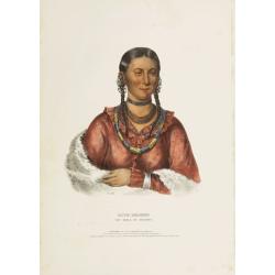
Hayne-Hudjihini the eagle of delight.
This hand-colored lithograph of Hayne-Hudjihini the eagle of delight, one of only eight women whose portraits appeared in this book. By contrast there were 111 men's port...
Date: Philadelphia, circa 1836-1842
Selling price: ????
Please login to see price!
Sold in 2008

Tens-Kwau-Ta-Waw - The prophet.
A beautifully defined lithograph of a half-length portrait of Tenskwautawaw with right eye closed, wearing earrings, silver armband and necklace, red sash across his ches...
Date: Philadelphia, circa 1836-1842
Selling price: ????
Please login to see price!
Sold in 2019