Browse Listings in America

Tens-Kwau-Ta-Waw - The prophet.
A beautifully defined lithograph of a half-length portrait of Tenskwautawaw with right eye closed, wearing earrings, silver armband and necklace, red sash across his ches...
Date: Philadelphia, circa 1836-1842
Selling price: ????
Please login to see price!
Sold in 2008

Chippeway Squaw & Child.
A beautifully defined lithograph of a Chippeway squaw and child, facing left. The woman is walking with head down, arms in blue blanket around her shoulders, child in car...
Date: Philadelphia, circa 1836-1842
Selling price: ????
Please login to see price!
Sold in 2008

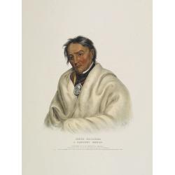
Kish-Kal-Wa. A Shawanoe chief.
A beautifully defined lithograph of a half-length portrait of Portrait of Kish Kal Wa, Shawanoe Chief. From McKenney & Hall's History of the Indian Tribes, perhaps th...
Date: Philadelphia, circa 1836-1842
Selling price: ????
Please login to see price!
Sold in 2008

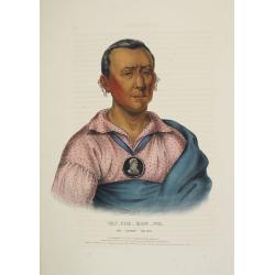
Red-Jacket A Seneca War chief.
A beautifully defined lithograph of a half-length portrait of the famous Seneca Indian Chief Red Jacket wearing his large-size, silver, oval 1792 Washington Peace Medal, ...
Date: Philadelphia, circa 1836-1842
Selling price: ????
Please login to see price!
Sold in 2008

Waa-Pa-Shaw. A Sioux Chief.
A beautifully defined lithograph of a half-length portrait of Waa-Pa-Shaw, better known as Wabasha, he was chief of a Kiowa tribe of the Mdewakanton Sioux. He was treated...
Date: Philadelphia, circa 1836-1842
Selling price: ????
Please login to see price!
Sold in 2008
Meta-Koosega. A chippeway warrior.
A beautifully defined lithograph of a half-length portrait of Meta-Koosega wearing an Indian Peace Medal, a blanket and black cravat. Disbound from McKenney and Hall's Hi...
Date: Philadelphia, circa 1836-1842
Selling price: ????
Please login to see price!
Sold in 2008
Wat-Che-Mon-Ne, an Ioway Chief.
A beautifully defined lithograph of Wat-Che-Mon-Ne, an Ioway Chief from McKenney & Hall's History of the Indian Tribes, perhaps the most important work ever published...
Date: Philadelphia, circa 1836-1842
Selling price: ????
Please login to see price!
Sold in 2008

Mar-Ko-Me-Te, a Menomene brave.
A beautifully defined lithograph of Mar-Ko-Me-Te, a Menomene brave from McKenney & Hall's History of the Indian Tribes, perhaps the most important work ever published...
Date: Philadelphia, circa 1836-1842
Selling price: ????
Please login to see price!
Sold in 2008

Le Soldat du Chene, an Osage Chief.
A beautifully defined lithograph of "Le Soldat du Chene, an Osage Chief " from McKenney & Hall’s History of the Indian Tribes, perhaps the most important ...
Date: Philadelphia, circa 1836-1842
Selling price: ????
Please login to see price!
Sold in 2008

Stum-Ma-Nu, a Flat-Head boy.
A beautifully defined lithograph of Stum-Ma-Nu, a Flat-Head boy from McKenney & Hall's History of the Indian Tribes, perhaps the most important work ever published on...
Date: Philadelphia, circa 1836-1842
Selling price: ????
Please login to see price!
Sold in 2008

Nea-Math-La, a Seminole Chief.
A beautifully defined lithograph of Nea-Math-La, a Seminole Chief from McKenney & Hall's History of the Indian Tribes, perhaps the most important work ever published ...
Date: Philadelphia, circa 1836-1842
Selling price: ????
Please login to see price!
Sold in 2008

Ahyouwaighs, Chief of the Six Nations.
A beautifully defined lithograph of Ahyouwaighs, Chief of the Six Nations from McKenney & Hall's History of the Indian Tribes, perhaps the most important work ever pu...
Date: Philadelphia, circa 1836-1842
Selling price: ????
Please login to see price!
Sold in 2008

Tai-O-Mah, a Musquakee brave.
A beautifully defined lithograph of Tai-O-Mah, a Musquakee brave from McKenney & Hall's History of the Indian Tribes, perhaps the most important work ever published o...
Date: Philadelphia, circa 1836-1842
Selling price: ????
Please login to see price!
Sold in 2008

Kee-Shes-Wa, a Fox Chief.
A beautifully defined lithograph of Kee-Shes-Wa, a Fox Chief from McKenney & Hall's History of the Indian Tribes, perhaps the most important work ever published on No...
Date: Philadelphia, circa 1836-1842
Selling price: ????
Please login to see price!
Sold in 2008

Wa-Baun-See, a Pottawatomie Chief.
A beautifully defined lithograph of Wa-Baun-See, a Pottawatomie Chief from McKenney & Hall's History of the Indian Tribes, perhaps the most important work ever publis...
Date: Philadelphia, circa 1836-1842
Selling price: ????
Please login to see price!
Sold in 2008

Le Soldat du Chene, an Osage Chief.
A beautifully defined lithograph of "Le Soldat du Chene, an Osage Chief " from McKenney & Hall’s History of the Indian Tribes, perhaps the most important ...
Date: Philadelphia, circa 1836-1842
Selling price: ????
Please login to see price!
Sold in 2011

Three Hand-colored Engravings of Quebec, Canada.
Three fine hand-colored Bartlett steel engravings of scenes in Quebec, Canada including: "Village of Cedars, River St. Lawrence", "Wolfe's Cove", and ...
Date: London, 1842
Selling price: ????
Please login to see price!
Sold in 2016
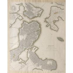
Boston with Charleston and Roxbury.
A highly detailed plan of Boston with Charleston and Roxbury. One of only three American Cities included in the series of town-plans which accompany some editions of the ...
Date: London, 1842
Selling price: ????
Please login to see price!
Sold in 2014
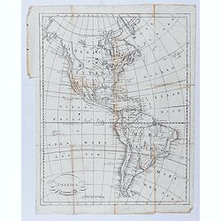
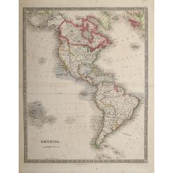
America.
Taken from "Atlas ethnographique du globe, ou classification des peuples anciens et modernes d'après leurs langues."
Date: Livorno, ca. 1842
Selling price: ????
Please login to see price!
Sold in 2020
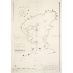
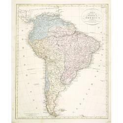
Plan de la Baie de Rio-Janeiro..
A detailed chart of the Rio de Janeiro bay with towns, buildings, banks, isles and soundings made in brasses a French measure of depth of water corresponding to the fatho...
Date: Paris [1829] 1843
Selling price: ????
Please login to see price!
Sold in 2008
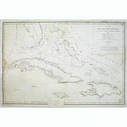
Carte des Grandes Antilles (Cuba, Haïti, Jamaïque, Archipel de Bahama..
Decorative focused on the Greater Antilles. Showing towns, banks, isles and soundings made in meters.Relief shown by hachures. Prepared by M. Keller, hydrographer and en...
Date: Paris, 1843
Selling price: ????
Please login to see price!
Sold in 2012
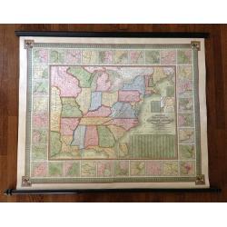
Mitchell's National Map of the American Republic or United States of North America Together with Maps of the Vicinities of Thirty -Two of the Principal Cities and Towns in the Union
Mitchell's National Map of the American Republic or United States of North America drawn by J.H. Young and engraved by J.H. Brightly. Map extends into the eastern part of...
Date: 1843
Selling price: ????
Please login to see price!
Sold in 2013

Pehriska-Ruhpa.
Aquatint from: 'Reise in das innere Nord-America in den Jahren 1832 - 1834' by Prince Maximilian of Wied-Neuwied, after paintings by Karl Bodmer, engraved by Paul Legrand...
Date: Paris, 1837-1843
Selling price: ????
Please login to see price!
Sold in 2015
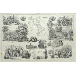
America.
Interesting sheet with a small map of the Americas surrounded by scenes and important places. From Wilhelm Penn with Indians; the Niagra Falls; Battle of Bunker Hill; vie...
Date: Stuttgart, ca. 1843
Selling price: ????
Please login to see price!
Sold in 2015
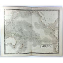
Islands in the Pacific Basin
A detailed map of islands in the Pacific Ocean with relief shown by hatchures. Centred on Hawaii., includes New Zealand, Australia, Japan etc. A decorative 'Piano Key' bo...
Date: Edinburgh, 1843
Selling price: ????
Please login to see price!
Sold in 2018
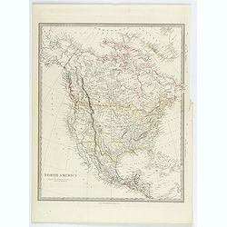
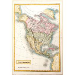
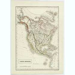
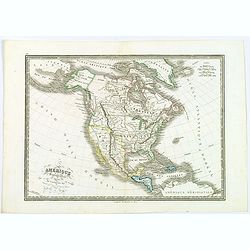
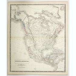
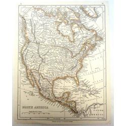
North America.
A detailed map of North America, published by Charles Knight in London for the S.D.U.K. Country borders are in different outline colors, TX is seen as a republic. Map ext...
Date: London ca 1843
Selling price: ????
Please login to see price!
Sold in 2019
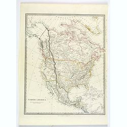
North America.
A detailed map of North America, published by Charles Knight in London for the S.D.U.K. Country borders are in different outline colors, TX is seen as a republic. Map ext...
Date: London ca 1843
Selling price: ????
Please login to see price!
Sold in 2019
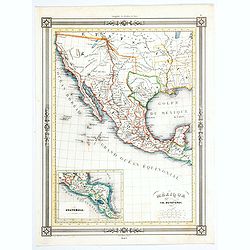
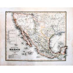
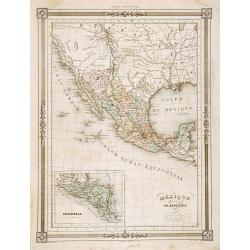
Mexique.
An uncommon map of Mexico from the French geographer Duvotenay, published in his many editioned Atlas Illustre.Cartographically, it shows Texas as a republic and depicts ...
Date: Paris, 1843
Selling price: ????
Please login to see price!
Sold in 2020
America.
Engraved, with colored margins of countries. Shows place names, roads, rivers, lakes, and islands. Relief shown with hachures. British possessions shown in red (Jamaica, ...
Date: London, 1844
Selling price: ????
Please login to see price!
Sold in 2013
North America.
This interesting transition map features Alaska as a part of Russia, California and Texas as a part of Mexico and Canada still "British Territories". Sidney H...
Date: London, 1844
Selling price: ????
Please login to see price!
Sold in 2013
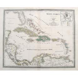
WEST INDIEN.
A large map of Florida, the Bahamas, the Caribbean Islands, and parts of Central America and South America.Highly detailed with many place names given. colors indicate th...
Date: Weimar, 1844
Selling price: ????
Please login to see price!
Sold in 2018
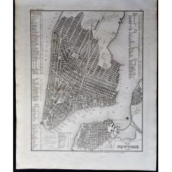
Plan von New-York 1844.
A detailed map of New York (Manhattan, Williamsburg, Brooklyn), based upon the work of Tanner, with a key naming around 200 prominent places and buildings (churches, hote...
Date: Leipzig, 1844
Selling price: ????
Please login to see price!
Sold in 2020
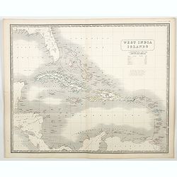
West India Islands.
A large-scale map of Florida, and the Caribbean, while also showing portions of Yucatan, Honduras, Guatemala, Panama, Cartagena and Venezuela, courtesy of the Johnston pu...
Date: Edinburgh, ca 1844
Selling price: ????
Please login to see price!
Sold in 2023
18 plates taken from <I>Rio de Janeiro Pitoresco.</I>
Group of 18 very rare lithographes made Heaton e Rensburg active in Rio de Janeiro. Edited by L. Buvelot after design of Auguste Moreau. Originating from RIO DE JANEIRO P...
Date: Rio de Janeiro 1845
Selling price: ????
Please login to see price!
Sold
Texas.
Rare map of Texas by Flemming. With counties outlined in color and an inset map of Galveston Bay.
Date: Glogau 1841 - 1845
Selling price: ????
Please login to see price!
Sold

Mandan Chef. / Chef Mandan.
Original lithograph by J. Honegger, after an aquarell by Karl Bodmer, for Maximilian Prinz zu Wied's': "Reise in das innere Nord-America in den Jahren 1832 bis 1834&...
Date: Zurich, 1845
Selling price: ????
Please login to see price!
Sold in 2015

Dacota-Krieger./ Guerrier Dacota.
Original lithograph by J. Honegger, after an aquarell by Karl Bodmer, for Maximilian Prinz zu Wied's's: “Reise in das innere Nord-America in den Jahren 1832 bis 1834”...
Date: Zurich, 1845
Selling price: ????
Please login to see price!
Sold in 2015

Fazenda du Secretario.. .Manicipe de Vassouras.
Scare lithograph of Fazenda du Secretario. Lithographed by Jacottet. After a photograph of Victor Frond.
Date: Paris, ca. 1845
Selling price: ????
Please login to see price!
Sold in 2015

Fazenda du Secretario Manicipe de Vassouras.
Scare lithograph of Fazenda du Secretario. Lithographed by Jacottet. After a photograph of Victor Frond.
Date: Paris, 1845
Selling price: ????
Please login to see price!
Sold in 2015
North America.
Sidney Hall's map of North America, showing Texas as a republic. Other interesting facts are that Alaska is still Russian Territory, Canada stretches down 'Western Territ...
Date: London, ca 1845
Selling price: ????
Please login to see price!
Sold in 2020
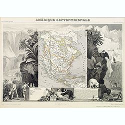
Amérique septentrionale.
An uncommon map of North America prepared by N.Lorrain, who worked for Dépot de la Guerre. Showing the state of Texas as a republic. Mexico occupied the south west, and ...
Date: Paris, 1845
Selling price: ????
Please login to see price!
Sold in 2020
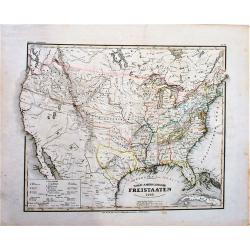
Nord-Americanische Freistaaten (shows Republic of Texas).
An attractive map of the United States just prior to the Mexican-American War. It shows a small Republic of Texas with its southwestern border on the Nueces River. The na...
Date: Hildburghausen, 1845
Selling price: ????
Please login to see price!
Sold in 2018
Neueste Karte von Mexico Nach den Besten Quellen . . . (shows Republic of Texas)
The Republic of Texas was a sovereign state from 1836 to 1845. It claimed a region including all of the present state of Texas, together with parts of present-day New Mex...
Date: Hildburghausen, 1845
Selling price: ????
Please login to see price!
Sold in 2018
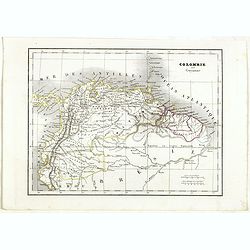
Colombie et Guyanne.
Detailed map of Colombia and Guyana / Surinam, prepared by Charles V. Monin (fl.1830-1880) a French cartographer of Caen and Paris. Published in Atlas Universel de Géogr...
Date: Paris, 1845
Selling price: ????
Please login to see price!
Sold in 2019
North America.
A detailed map of North America by William and Alexander Keith Johnston, a well-known publisher of maps who continually updated his maps. From his National Atlas of Geogr...
Date: Edinburgh, ca 1845
Selling price: ????
Please login to see price!
Sold in 2023
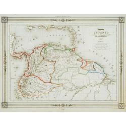
Colombie et Guyanes..
Decorative map of Colombia, Venezuela, Surinam, prepared by J.G.Barbié du Bocage.Engraved by Ch.Smith, published by Basset who was established in Paris, rue de Seine 33....
Date: Paris 1846
Selling price: ????
Please login to see price!
Sold
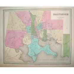
Baltimore.
Decorative town plan of Baltimore. The map highlight's the city's 14 boroughs and provides excellent street detail.Baltimore was a major commercial center during America'...
Date: Philadelphia and Boston, 1838 - corrected to 1846
Selling price: ????
Please login to see price!
Sold in 2011
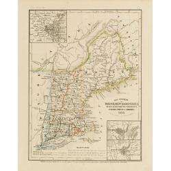
Die staaten von Maine, New Hampshire, Massachusetts, Vermont.
Detailed map of Maine, New Hampshire, Massachusetts, Vermont, Connecticut and Rhode Island with numerous physical and political features including mines, settlements, tra...
Date: Hildburghausen/ Philadelphia, 1846
Selling price: ????
Please login to see price!
Sold in 2011
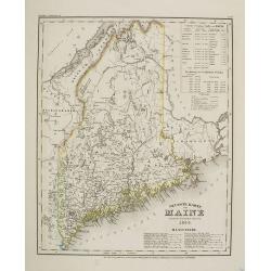
Neueste Karte von Maine nach den bessten Quellen verbessert.. 1845. N° 75.
Detailed map of Maine with numerous physical and political features including mines, settlements, trails/roads, forts and Indian areas. From J. Meijer's Grossem Handatla...
Date: Hildburghausen / Philadelphia, 1846
Selling price: ????
Please login to see price!
Sold in 2009
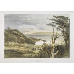
Vue des environs de Port Famine (Detroit de Magellan)
Exquisite contemporary colored lithograph of Port Famine in most southern part of South America, with Dumont D'Urville's officers hunting. Drawn by Ernest Goupil (died 18...
Date: Paris, 1846
Selling price: ????
Please login to see price!
Sold in 2010
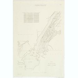
Plan der insel und stadt New-York. Bl. 18.
Steel engraved town-plan of New York, from "Algemeine Bauzeitung". In top "Nord Amerikanische Bauart. L"art de bâtir en Amerique sept.".Uncommon...
Date: Berlin, 1846
Selling price: ????
Please login to see price!
Sold in 2011
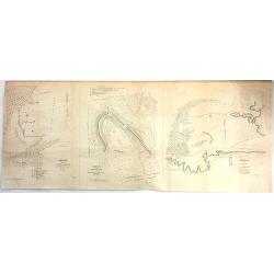
Sketch of the Battle Ground at Palo Alto, (Texas) (One of three maps)
The other two maps are “Sketch of the Battle Ground at Palo Alto, Texas” and "Sketch of the Main Road from fort Brown to Point Isabel Island”.These three maps ...
Date: Wahsington, 1846
Selling price: ????
Please login to see price!
Sold in 2017
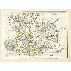
Die staaten von Arkansas, Mississippi, Louisiana & Alabama 1850
Detailed steel engraved map with very nice detail of the major cities, roads and railways. Little Rock is also named "Arkopolis". From Meijers Zeitungs Atlas pu...
Date: Hildburghausen/ Philadelphia, 1846
Selling price: ????
Please login to see price!
Sold in 2014
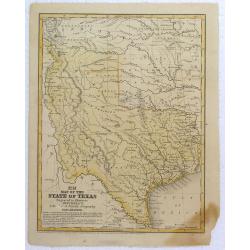
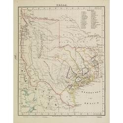
Map of the State of Texas.
Early map of Texas, a year after annexation, from Mitchell's school & Family Geog. Dated in plate.
Date: Pennsylvania, 1846
Selling price: ????
Please login to see price!
Sold in 2016
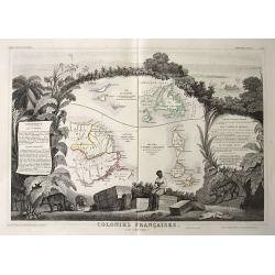
Colonies Francaises (en Amérique).
Steel engraved map of French colonies in America. Shows four maps on one sheet: 1) Saint Martin (French: Saint-Martin; Dutch: Sint Maarten) 2) Ile de Terre Neuve + I...
Date: Paris, 1846
Selling price: ????
Please login to see price!
Sold in 2016
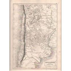
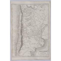
Chili, La Plata and Part of Bolivia.
Sidney Hall's map of Chili published in London by Adam & Charles Black.
Date: London, 1846
Selling price: ????
Please login to see price!
Sold in 2018
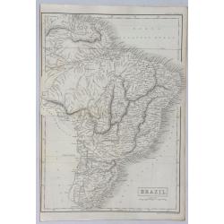
Brazil.
A detailed map of Brazil in South America from Adam & Charles Black, who were among the leading publishers of atlases and travel books in the 19th Century in England....
Date: London, 1846
Selling price: ????
Please login to see price!
Sold in 2021
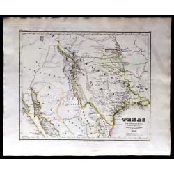
Texas, 1846.
RARE! The first year Texas as a state. A large lithographic map showing the state of Texas, with county boundaries, in original hand coloring. It shows the brand new stat...
Date: Leipzig, 1846
Selling price: ????
Please login to see price!
Sold in 2020
![DIE VEREINIGTEN STAATEN VON NORD-AMERICA .. 1846 [Texas Republic]](/uploads/cache/85591-250x250.jpg)
DIE VEREINIGTEN STAATEN VON NORD-AMERICA .. 1846 [Texas Republic]
Rare late edition of Streit's fascinating map of the United States with inset maps of the region around Washington DC, Boston, Philadelphia, and New York. Very nice detai...
Date: Leipzig, 1846
Selling price: ????
Please login to see price!
Sold in 2021
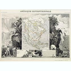
Amerique Septentrionale.
Beautiful map with the United States.
Date: Paris, 1847
Selling price: ????
Please login to see price!
Sold in 2017
![Map No.5 United States [Alabama, Georgia, South Carolina, Florida].](/uploads/cache/39987-250x250.jpg)
Map No.5 United States [Alabama, Georgia, South Carolina, Florida].
A pleasant map of the S.E. corner of the United States, each state colored differently. A few lines of explanation beneath the plain title.Most major towns and cities dep...
Date: New York, 1847
Selling price: ????
Please login to see price!
Sold in 2017
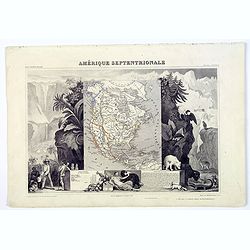
Amerique Septentrionale.
A beautiful map with the United States with Texas as a republic, and extending into present day Canada, Russia in control of Alaska, and Mexico's northern border defined ...
Date: Paris, 1847
Selling price: ????
Please login to see price!
Sold in 2017
Amerique Septentrionale.
Beautiful map with the United States extending into present day Canada, Russia in control of Alaska and Mexico's northern border according to the Treaty of 1810. Surround...
Date: Paris, 1847
Selling price: ????
Please login to see price!
Sold in 2019
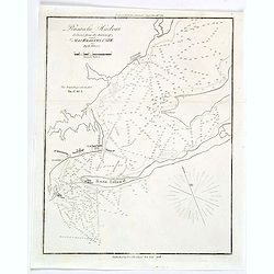
Pensacola Harbour.
A small naval chart of Pensacola Harbour and surrounds in Florida, reduced from a survey of Major Kearney, U.S.T.E. It features depth soundings (measured in feet), a Ligh...
Date: New York, 1847
Selling price: ????
Please login to see price!
Sold in 2019
Mécique..
Detailed map of Mexico and California, prepared by Th.Duvotenay.Engraved by Ch.Smith, published by Basset who was established in Paris, rue de Seine 33.
Date: Paris 1848
Selling price: ????
Please login to see price!
Sold
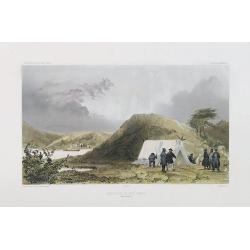
Observatoire de Port Famine. (Detroit de Magellan)
Exquisite contemporary colored lithograph of the Port Famine, situated in the southern tip of America, with Dumont D'Urville's officers discussing in front of a tenth. Dr...
Date: Paris, 1848
Selling price: ????
Please login to see price!
Sold in 2017
Karta öfver Södra America.
An very rare map of South America with Swedish text. The map is dated 1825. In upper right corner Suppl. 2.From his atlas "Geographisk Hand-Atlas" first publish...
Date: A. Wiborgs förlag, Stockholm, ca. 1848
Selling price: ????
Please login to see price!
Sold in 2014
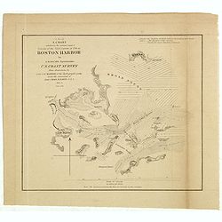
A chart exhibiting the normal course & velocity of the tidal current at ebb in Boston Harbor.
Interesting map of the currents in the Boston harbor.
Date: Washington, 1848
Selling price: ????
Please login to see price!
Sold in 2013
North America.
Published by Chapman and Hall from "Sharpe's Corresponding Maps".
Date: London, 1848
Selling price: ????
Please login to see price!
Sold in 2019
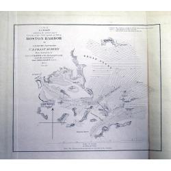
A chart exhibiting the normal course & velocity of the tidal current at ebb in Boston Harbor.
Interesting map of the currents in the Boston harbour. With many of the islands, among them: Thompson I., Spectacle I., Long I., Deer I., Lovells I., Peddocks I., Nahant ...
Date: Washington, 1848
Selling price: ????
Please login to see price!
Sold in 2020
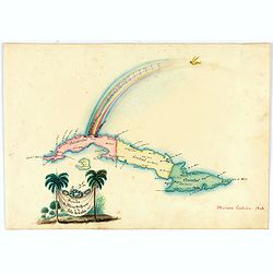
Arribo de Albina Steffanoni a la Isla de CUBA. 1848.
Fine manuscript map of Cuba made on the occasion of the visit of soprano Balbina Steffenone to Cuba in 1848. The map is carefully drawn and heightened by watercolors, orn...
Date: Habana, 1848
Selling price: ????
Please login to see price!
Sold in 2022

20 small lithographed views of Washington DC and Georgetown.
20 small lithographed town-views of Washington DC and Georgetown, cut out from a larger sheet. Showing the East Front of the Capitol, Treasury, Smithsonian Institute, Pre...
Date: Casimir Bohn, Washington, D.C.: 1849
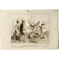
Arrivée d'une famille en Californie.
Four pages of Le Charivari a satiric magazine for which Cham prepared and lithographed many illustration.Humoristic view of an arrival of a family in California. Ah! mon ...
Date: Paris 1849
Selling price: ????
Please login to see price!
Sold
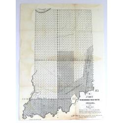
Three Early Government Survey Maps of Indiana.
Three of the earliest obtainable government survey maps of Indiana. 1) No. 1, R,” Index to Recorded Field Notes, Indiana”. Maker: General Land Office. Washington, 184...
Date: Washington, 1845-1849
Selling price: ????
Please login to see price!
Sold in 2019
Chili, La Plata and Part of Bolivia.
A detailed map of South America from Adam & Charles Black who were among the leading publishers of atlases and travel books in the 19th Century in England. Engraved b...
Date: Edinbourgh, 1849
Selling price: ????
Please login to see price!
Sold in 2021
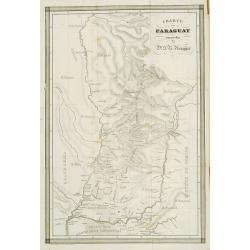
Charte von Paraguay entworfen von Dr. J.R.Rengger.
Detailed map of Paraguay. Lithographed by father and son Engelmann.
Date: Mulhouse 1850
Selling price: ????
Please login to see price!
Sold
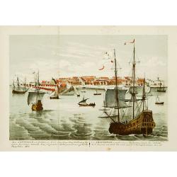
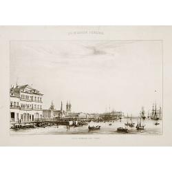
Nieu Amsterdam, een stedeken in Noord Amerikaes,..
Lithographed view of New York, seen from the harbour. Text in English underneath. Copied after P.Schenk.Important view of New York City which celebrates the Dutch recap-t...
Date: London 1850
Selling price: ????
Please login to see price!
Sold
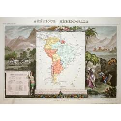
Amerique Meridionale.
A very decorative 19th century map of the continent colored to show political divisions. The map is surrounded by fully colored, steel engraved scenes including horses, I...
Date: Paris 1850
Selling price: ????
Please login to see price!
Sold
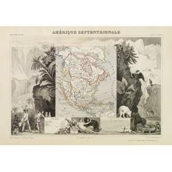
Amérique Septentrionale.
A very decorative map with the United States extending into present day Canada, Russia in control of Alaska and Mexico's northern border according to the Treaty of 1810. ...
Date: Paris 1850
Selling price: ????
Please login to see price!
Sold
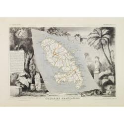
Colonies Françaises. Martinique - Amérique du Sud.
A very decorative 19th century map of the Martinique Island. The map is surrounded by the products of the island like tobacco, sugar, etc. A decoration of trees and birds...
Date: Paris 1850
Selling price: ????
Please login to see price!
Sold