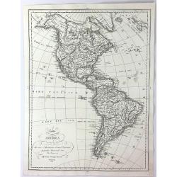
Browse Listings in America
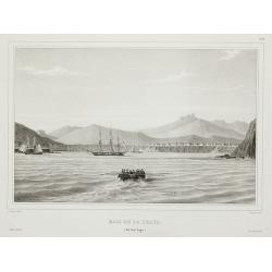
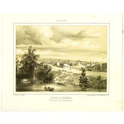
Baie de la praya. (Ile San lago.).
View of the Cape Verde from Voyage de la corvette l’Astrolabe exécuté par Ordre du Roi pendant les années 1826 – 1827 – 1828 – 1829 sous le commandement de M. ...
Date: Paris, 1830
Selling price: ????
Please login to see price!
Sold in 2011

Notre-Dame de gloire. (à Rio de Janeiro).
Beautiful Brazilian landscape with the Notre-Dame de gloire church in background. After Auguste Borget (1808-1877), in upper right corner "Plate 2".
Date: Moulins, ca. 1830
Selling price: ????
Please login to see price!
Sold in 2008

Balsas (Bateaux de Pêche) sur la Côte de Bolivie.
A fishing scene along the Bolivian coast. After Auguste Borget (1808-1877), in upper right corner " Plate 10."
Date: Moulins, ca. 1830
Selling price: ????
Please login to see price!
Sold in 2009
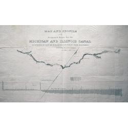
MAP AND PROFILE of the Proposed Route for the MICHIGAN AND ILLINOIS CANAL SURVEYED IN 1830 by W. B. GUION & H. BELIN CIVIL ENGINEERS reduced from the original drawing by J. R. IRWIN LIEUT. U.S.A.
Large scale plan of the Illinois Michigan Canal. Shows landmarks along its course. With the profile of Lake Michigan underneath the map. Unusual and interesting item!
Date: c1830
Selling price: ????
Please login to see price!
Sold in 2013
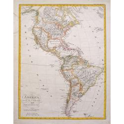
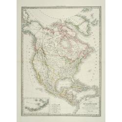
America entworfen von C. G. Reichard...
Unusual German map of the Americas, published in an early edition of Stielers Hand-Atlas. Dated 1816, improved 1828. Includes interesting details in North America, for e...
Date: Gotha, ca. 1830
Selling price: ????
Please login to see price!
Sold in 2015
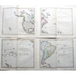
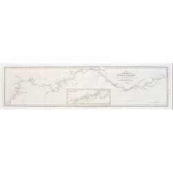
America.
Lizar's fantastic 4-sheet map of the Americas, pubslished by Daniel Lizars son, William Hole Lizars. The map shows an unfinished coast lines towards the Northwest Passage...
Date: Edinburgh, ca 1830
Selling price: ????
Please login to see price!
Sold in 2019
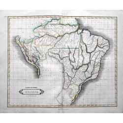
Lower Peru, Brazil & Paraguay.
Daniel Lizars fine map of Brazil, Paraguay, and parts of Peru, pubslished by his son William Lizars. With mountains, rivers, areas, cities, etc. Bolivia and Colombia left...
Date: Edinburgh, ca 1830
Selling price: ????
Please login to see price!
Sold in 2019
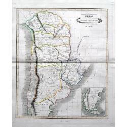
Bolivia or upper Peru; Chili and the United Provinces of South America or La Plata.
Daniel Lizars fine map of Bolivia, Chili, todays Argentina and Uruguay, pubslished by his son William Lizars. An inset map shows Patagonia. With the road from Valparaiso ...
Date: Edinburgh, ca 1830
Selling price: ????
Please login to see price!
Sold in 2019
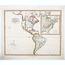
North & South America for the Elucidation of the Abbe Gaultier's Geographical Games.
An original 19th century antique map of the Americas, with an inset detail map of the eastern United States. Further enhanced with attractive hand coloring. The Abbe Gaul...
Date: London, ca 1830
Selling price: ????
Please login to see price!
Sold in 2023
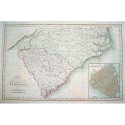
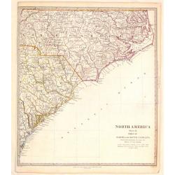
Map of the States of North & South Carolina..
An increasingly scarce map of North and South Carolina. This was one the first maps to provide accurate border divisions for the Carolina counties. Moreover, it was one o...
Date: London, 1831
Selling price: ????
Please login to see price!
Sold
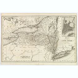
Map of the State of New York with part of Upper Canada.
A scarce early map of New York, showing towns, roads, rivers, lakes, mountains, islands, canals, etc. Inset map of Manhattan. One of the earliest separate maps of the sta...
Date: London, 1831
Selling price: ????
Please login to see price!
Sold in 2018
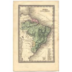
Brazil, with Guiana & Paraguay.
Plate 99 from Carey & Lea's "Family Cabinet atlas. First American edition..." With text leaf giving names of towns and latitude coordinates. This was the f...
Date: Philadelphia, 1832
Selling price: ????
Please login to see price!
Sold in 2015
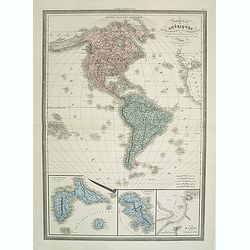
Nouvelle Carte des Ameriques Septentrionale et Meridionale
Large, skillfully engraved, and quite scarce map of North and South America, with insets at bottom of Guadeloupe, Martinique, and Plan de Cayenne.
Date: Paris, Garnier Fréres, 1832
Selling price: ????
Please login to see price!
Sold in 2011
Plan of New York Island and part of Long Island Shewing the Position of the American & British Armies. . .
A rare chromolithographed map of New York City done during the American Revolutionary War. Issued for John Marshall's 1832 edition of the “Life of Washington”. The ma...
Date: Philadelphia, 1832
Selling price: ????
Please login to see price!
Sold in 2018
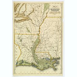
Map of the States of Mississippi, Louisians, and the Arkansas Territory.
An impressive steel engraved map of the southern American states of MS, LA, AR. by Isaac Hinton, published in "The History and Topography of the United States of Ame...
Date: London, 1832
Selling price: ????
Please login to see price!
Sold in 2018
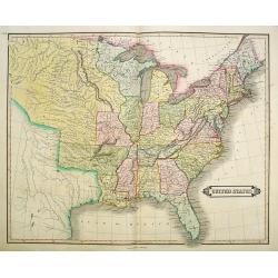
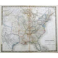
United States.
"Uncommon detailed steel engraved map of the United States. Published in Edinburgh by Daniel Lizars. A detailed showing the states and territories from Missouri east...
Date: Edinburgh 1833
Selling price: ????
Please login to see price!
Sold
Mapa de la Provincia de Buenos-Aires.
Folding-map of the city of Buenos Aires in Argentina. Cesár Hipólito Bacle, Swiss engraver and litographer, established the first lithographic shop in Buenos Aires.
Date: Buenos-Aires, 1833
Selling price: ????
Please login to see price!
Sold in 2008

Hémisphére Occidental.
Uncommon map of the western hemisphere. Published by F.G.Levrault, who was active in Strasbourg, Rue des Juifs, 33 and Paris, rue de la Harpe, 81.
Date: Strasbourg 1833
Selling price: ????
Please login to see price!
Sold in 2014
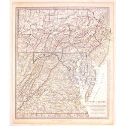
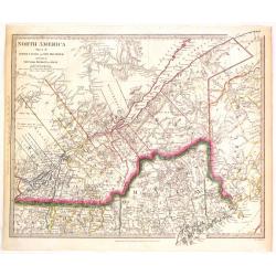
North America (Sheet VII) Pennsylvania, New Jersey, Maryland, Columbia and part of Virginia.
Very detailed sectional map of North America published by Baldwin & Cradock under the superintendence of the Society for the Diffusion of Useful Knowledge in London i...
Date: London, 1833
Selling price: ????
Please login to see price!
Sold in 2017
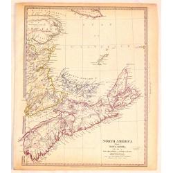
North America (Sheet 1) Nova Scotia with Part of New Brunswick and Lower Canada.
Very detailed sectional map of North America published by Baldwin & Cradock under the superintendence of the Society for the Diffusion of Useful Knowledge in London i...
Date: London, 1833
Selling price: ????
Please login to see price!
Sold in 2018
North America (Sheet XI) North and South Carolina.
Very detailed sectional map of North America published by Baldwin & Cradock under the superintendence of the Society for the Diffusion of Useful Knowledge in London i...
Date: London, 1833
Selling price: ????
Please login to see price!
Sold in 2017
North America (Sheet II) Lower Canada and New Brunswick with a Part of New York, Vermont and Maine.
Very detailed sectional map of North America published by Baldwin & Cradock under the superintendence of the Society for the Diffusion of Useful Knowledge in London i...
Date: London, 1833
Selling price: ????
Please login to see price!
Sold in 2015
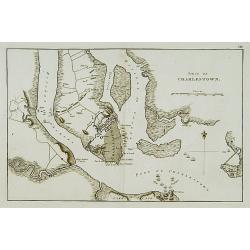
Siége de Charlestown.
Map showing vicinity around Charlestown. Showing a detailed plan of the town, roads, rivers or creeks & positions of the English troops.A french version of a map from...
Date: Paris, c. 1834
Selling price: ????
Please login to see price!
Sold
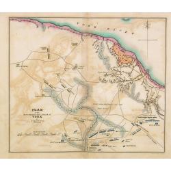
Plan of the investment and attack on York in Virginia.
Map showing vicinity around York, VA. Shows American artillery, French Hospital, roads, rivers or creeks & positions of troops. Also, note Field where the British lai...
Date: Philadelphia, 1806 -1834
Selling price: ????
Please login to see price!
Sold in 2014
Réunion de la riviere Pierre Jaune avec le Missouri.
Original aquatint engraving after Karl Bodmer. Engraved by Salethé and printed by Bougeard.Karl Bodmer was engaged by Prince Maximilian to provide a record of his travel...
Date: Paris, 1834
Selling price: ????
Please login to see price!
Sold in 2019
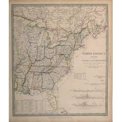
North America, Index Map of Canada and the United States,
Map published by the SDUK/Society for the Diffusion of Useful Knowledge. Shows the United States east of the Mississippi, and parts of Canada, and includes the Census of ...
Date: London, 1834
Selling price: ????
Please login to see price!
Sold in 2012
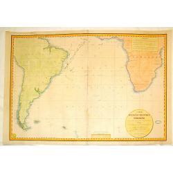
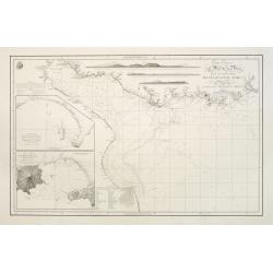
Carte de L'Ocean Atlantique Meridional.
Large important sea chart showing the Atlantic Ocean with the southern part of South America and Africa. It is by C.L. Gressier.Depôt des Cartes et Plans de la Marine (1...
Date: Paris, 1834
Selling price: ????
Please login to see price!
Sold in 2016
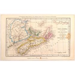
Nova Scotia, New Brunswick, Cape Breton & Prince Edward Island.
A map of the Maritime Provinces of Canada from 33 years before Canada was formed. Published by J. Cochrane & Co for Montgomery Martin's History of the British Coloni...
Date: London, 1834
Selling price: ????
Please login to see price!
Sold in 2016
Carta dell America
A detailed map of the Americas by Giuseppe Antonelli in Venice in 1834. It is interesting to see the large land area in the north west named "America Russa".
Date: Venice, 1834
Selling price: ????
Please login to see price!
Sold in 2016
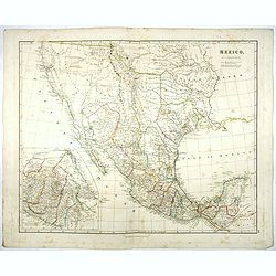
Mexico.
A first state of this detailed map of southwestern United States, all of Texas, the Southwest and California to above San Francisco, and east to the Mississippi River, an...
Date: London, 1832-1834
Selling price: ????
Please login to see price!
Sold in 2017
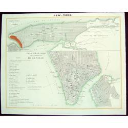
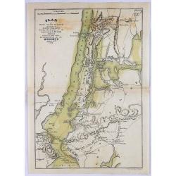
NEW-YORK
A scarce, uncommon early 19th-century French plan of New York City. The work is finely rendered and provides two different plans of the city. The upper portion consists o...
Date: Paris, dated 1835
Selling price: ????
Please login to see price!
Sold in 2008

"View of Baltimore"
A small but beautiful early 19th century view of Baltimore as seen from its Inner Harbour. Many important city sites are clearly visible. A very fine steel plate engravin...
Date: London, 1835
Selling price: ????
Please login to see price!
Sold
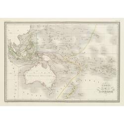
Carte de l'Océanie.
Steel engraving of Australia, New Zealand and Indonesia. Engraved by Thierry.Published by Conrad Malte-Brun (1775-1826). Mapping of Australia [+]
Date: Paris, c.1835
Selling price: ????
Please login to see price!
Sold in 2023

VUE DE L'ETABLISSEMENT DES MISSIONS À ST. JOHNS DANS L'ISLE D'ANTIGOA AUX INDES ORIENTALES
Extremely rare and important aquatint view of Antigua! Based on original works by L. Stobwasser, engraved by Franz Hegi. Illustrates a scene of island life with slaves ...
Date: Basle, 1835
Selling price: ????
Please login to see price!
Sold in 2009
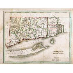
CONNECTICUT AND RHODE ISLAND
Detailed map of Connecticut and Rhode Island, with Block Island and also Long Island. The outline coloring indicates the county and state borders. Published in the popul...
Date: Boston, 1835
Selling price: ????
Please login to see price!
Sold in 2011

Vue de Gracehill dans l'Isle d'Antigoa...
Extremely rare and important aquatint view of Antigua!Based on original works by L. Stobwasser, engraved by Hürlimann.Illustrates a scene of island life at the Gracehill...
Date: Basle, 1835
Selling price: ????
Please login to see price!
Sold in 2009
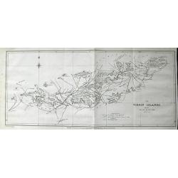
The Virgin Islands, shewing The Set of The Tide amongst them. . .
Highly important lithograph map of the Virgin Islands, published by John Murray. Extending from Green and Brigantine Islands just east of St. Thomas to Virgin Gorda in th...
Date: London, 1835
Selling price: ????
Please login to see price!
Sold in 2011
America Settentrionale..
Rare and detailed map of the northern part of the United States of America and Canada, including Alaska, engraved by Marco Zuliani. According to the title cartouche, prep...
Date: Venice, 1835
Selling price: ????
Please login to see price!
Sold in 2011
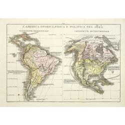
L\'America storica, fisica e politica nel 1825.
Rare and detailed map of the northern and southern part of America. According to the information on the map, prepared by Las Casas A de La Sage . From l'Atlante St.Geog.P...
Date: Venice, 1835
Selling price: ????
Please login to see price!
Sold in 2011

Port Louis à l'ile de France. (Mauritius)
Aquatint by Sigismond Himely (1801-1872) after Walter Paris (fl.1849-1891) published in "Laplace, Voyage autour du monde" by Sainson. Rare view of Port Louis on...
Date: Paris, 1835
Selling price: ????
Please login to see price!
Sold in 2011
Stati-Uniti Dell'America settentrionale. . .
Rare and detailed map of eastern part of the United States of America, including Great Lakes, Florida, engraved by Marco Zuliani. According to the title cartouche, prepar...
Date: Venice, 1835
Selling price: ????
Please login to see price!
Sold in 2011
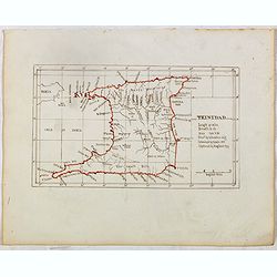
TRINIDAD . . .
Finely executed pend drawing in brown ink with coast line in red color. Scale is in English miles. Underneath the title an explanation.
Date: ca. 1835
Selling price: ????
Please login to see price!
Sold in 2015
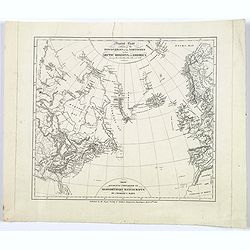
Carte des Découvertes faites dans les régions arctiques en 1829,30,31,32,33. Par John Ross...
An interesting map of an area in the Canadian arctic region 'Nunavut', with parts of Baffin Island, Somerset Island, Baffin Bay, Prince Regent Inlet, and Boothia Gulf.Inc...
Date: Paris, 1835
Selling price: ????
Please login to see price!
Sold in 2016
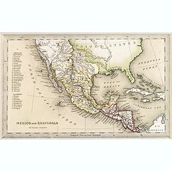
Mexico and Guatimala.
A map that has Central America split into two regions one oulined in red, the other in yellow. This is when Mexico still had possession of large swathes of California, an...
Date: London, ca. 1835
Selling price: ????
Please login to see price!
Sold in 2016
United States.
A detailed map of the United States shown until Texas and the Western Territory. Shows a large area labeled Nebraska.Includes some of the first railroads along the East C...
Date: London, ca. 1835
Selling price: ????
Please login to see price!
Sold in 2017
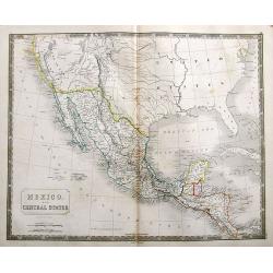
Mexico. And Central States Corrected from original information communicated by Simon A.G. Bourne Esq.
An important map of the South-West US, with Texas and Upper, or New California. With excellent detail throughout Mexico and until Costa Rica.Mines in Mexico are noted by ...
Date: London, ca. 1835
Selling price: ????
Please login to see price!
Sold in 2018
Carte des Decouvertes Faites dans lesRegions Arctiques en 1829-33.
An informative and important map of the discoveries made in the Arctic Regions in 1829-33 by Sir John Ross (1777-1856) in the Hydrographic Office of the Admiralty. Engrav...
Date: Paris, 1835
Selling price: ????
Please login to see price!
Sold in 2017
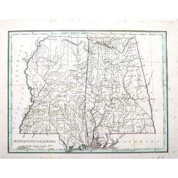
Mississippi & Alabama.
An important map by the American mapmaker Thomas Bradford. With fine detail including counties, towns, rivers, Indian nations, and the railroads of the time.
Date: Boston, ca. 1835
Selling price: ????
Please login to see price!
Sold in 2018
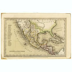
Mexico and Guatimala. By Thomas Starling.
A map that has Central America split into two regions; one outlined in red, the other in yellow. This is when Mexico still had possession of large swathes of California, ...
Date: London, ca. 1835
Selling price: ????
Please login to see price!
Sold in 2019
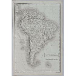
South America.
A detailed map of South America from Sidney Hall's extremely scarce 1835 “New General Atlas”. Adam & Charles Black were among the leading publishers of atlases an...
Date: London, 1835
Selling price: ????
Please login to see price!
Sold in 2022

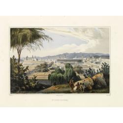
Vista General De Zacatecas.
View of Zacatecas, foreground with three giant magueys and a man harvesting.From the rare and famous "Voyage pittoresque et archéologique dans la partie la plus int...
Date: Paris, 1836
Selling price: ????
Please login to see price!
Sold in 2014

Vista de Jalapa.
View of Jalapa from a distance, foreground with Native trudging up a hill, figures in middle ground.From the rare and famous "Voyage pittoresque et archéologique da...
Date: Paris, 1836
Selling price: ????
Please login to see price!
Sold in 2014

Pirámide De Cholula.
Ethereal landscape with road leading up to Cholula in the distance. Light foxing in margins, otherwise fine. From the rare and famous "Voyage pittoresque et archéol...
Date: Paris, 1836
Selling price: ????
Please login to see price!
Sold in 2014

Interior de México.
Plaza of Mexico with cathedral at left, coaches, riders, muleteer with team kicking up dust, carriers and pedestrians, mountains in background. Very fine. From the rare a...
Date: Paris, 1836
Selling price: ????
Please login to see price!
Sold in 2014

Plaza Mayor De Guadalajara.
Main Plaza of Guadalajara with prominent fountain and people milling about. Very fine. From the rare and famous "Voyage pittoresque et archéologique dans la partie ...
Date: Paris, 1836
Selling price: ????
Please login to see price!
Sold in 2016

Veracruz.
Beautifully view of Veracruz Plaza with carts, riders, and figures, background with ocean and ships.From the rare and famous "Voyage pittoresque et archéologique da...
Date: Paris, 1836
Selling price: ????
Please login to see price!
Sold in 2016
St. Luis-Potosí.
Landscape with indigenous people resting on rocks near stand of cacti in foreground, San Luis Potosí and mountains in background.From the rare and famous "Voyage pi...
Date: Paris, 1836
Selling price: ????
Please login to see price!
Sold in 2014

MEXICO. Visto desde el Arsobisdabo de Tacubaya.
From the rare and famous "Voyage pittoresque et archéologique dans la partie la plus intéressante du Mexique par C. Nebel, Architecte.". 50 Planches Lithograp...
Date: Paris, 1836
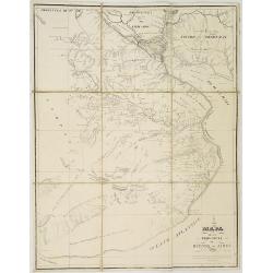
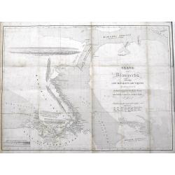
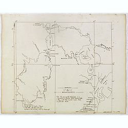
Plan of the Rivers Ucayali and Amazon from the Mission of Sarayacu to the Rio Negro, from the Observations of Lieut W.m Smyth & Mr Fred.k Lowe.
Copperplate engraved map of the Amazon, engraved by John Walker. Published by John Murray, Albemarle Street, London.Smyth and Lowe of the Royal Navy followed the Amazon i...
Date: London 1836
Selling price: ????
Please login to see price!
Sold
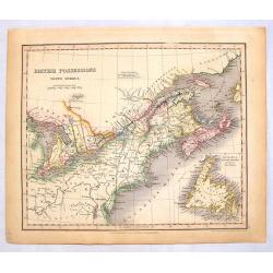
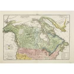
British Possessions (North America)
Striking lithograph map of Upper & Lower Canada featuring a cutout of Newfoundland. Published in 1836 by Orr & Company in London 31 years before the formation of ...
Date: London, 1836
Selling price: ????
Please login to see price!
Sold in 2014

Four Bartlett steel Engravings - North American Rivers.
Four fine steel engraving prints by William Bartlett. Included are:- The Banks of the River Niagara- Bridge Near Quebec- The Outlet of Niagara River - Wolf's CoveWilliam ...
Date: London, 1836
Selling price: ????
Please login to see price!
Sold in 2016
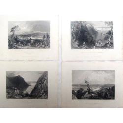
Four Bartlett steel engravings featuring North East American scenes.
Four fine steel engraving prints by William Bartlett. Included are: - VALLEY OF THE CONNECTICUT - HUDSON HIGHLANDS - VILLA ON THE HUDSON, NEAR WEEHAWKEN - VIEW OF MER...
Date: London, 1836
Selling price: ????
Please login to see price!
Sold in 2017
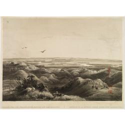
SOURCE OF THE MISSISSIPPI .
Finely executed pen drawing in brown ink. Scale is in English miles with many annotations.
Date: ca, 1836
Selling price: ????
Please login to see price!
Sold in 2015
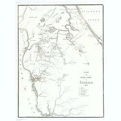
A Map of the Seat of War in Florida 1836.
This is the first map by Major Gen. W. Scott to highlight the progress of the Native American Seminole Wars. The map shows most of northern Florida from Charlotte Harbour...
Date: United States, ca 1836
Selling price: ????
Please login to see price!
Sold in 2018
Rancheros.
The famous group of rancheros in local dress with one rider and three other men at left. From the rare and famous "Voyage pittoresque et archéologique dans la parti...
Date: Paris, M. Moench, Cité Bergère, 1836
Selling price: ????
Please login to see price!
Sold in 2020
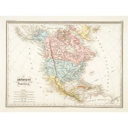
Amérique Septentrionale.
Fine map of North America.From Malte-Brun's Atlas Géographie Universelle.."., revised by Jean Jacques Nicolas Huot.This very fine executed map has been printed by F...
Date: Paris, 1837
Selling price: ????
Please login to see price!
Sold in 2011
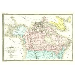
Amérique Ruse, Nouvelle Bretagne et Groenland.
Detailed map of Canada and Alaska.From Malte-Brun's Atlas Géographie Universelle.., revised by Jean Jacques Nicolas Huot.This very fine executed map has been printed by ...
Date: Paris 1837
Selling price: ????
Please login to see price!
Sold
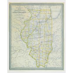
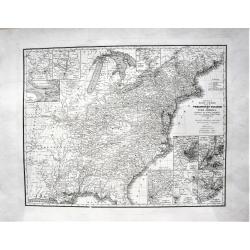
Mitchell's map of illinois exhibiting its internal improvements,
Detailed book illustration map of Illinois with railroads in red on crisp paper in blue print. Shows roads and stage roads. Very scarce map from Mitchell's Illinois in 18...
Date: Philadelphia 1837
Selling price: ????
Please login to see price!
Sold

Pont de Santiago sur le Rio Mapocho.
Drawn by V. Adam and engraved by Benard and Frey. From Bougainville's "Journal de la navigation autour du globe de la fregate la Thetis et de la corvette l'Esperance...
Date: Paris, 1837
Selling price: ????
Please login to see price!
Sold in 2011
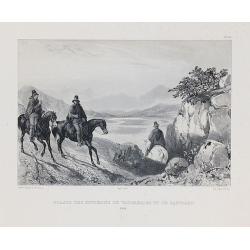
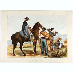
Guasos des environs de Valparaiso et de Santiago.
Drawn by V. Adam and engraved by Benard and Frey. From Bougainville's "Journal de la navigation autour du globe de la fregate la Thetis et de la corvette l'Esperance...
Date: Paris, 1837
Selling price: ????
Please login to see price!
Sold in 2010
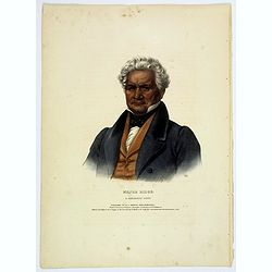
Major Ridge. A Cherokee Chief.
Head and shoulders portrait of Major Ridge,(1771-1839) wearing a blue jacket, gold or yellow vest, white shirt, and black cravat. A Cherokee Chief, who as a Cherokee lead...
Date: Philadelphia, 1837
Selling price: ????
Please login to see price!
Sold in 2017
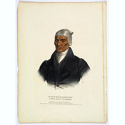
Ca-Ta-He-Cas-Sa-Black Hoof. Principal Chief of the Shawanoes.
Half-length portrait of Catahecassa wearing a dark colored jacked, grey vest, white shirt, and grey head scarf.A wonderful hand colored lithograph of Ca-Ta-He-Cas-Sa-Blac...
Date: Philadelphia, 1837
Selling price: ????
Please login to see price!
Sold in 2017

A-Na-Cam-E-Gish-Ca. A Chippeway Chief.
Half-length portrait of Anacamegishca, bare-chested, wearing a blanket and a peace medal. A-Na-Cam-E-Gish-Ca (1785-1862) - was a Chippeway Indian Chief. The Chippewa is o...
Date: Philadelphia, 1837
Selling price: ????
Please login to see price!
Sold in 2017
General Chart exhibiting the Discoveries of the Northmen in the Arctic Regions and America. . .
An interesting Danish map of many northern discoveries from the 10th to the 14th centuries, published by the Royal Society of Northern Antiquaries in Denmark. Map is base...
Date: Copenhagen, 1837
Selling price: ????
Please login to see price!
Sold in 2017
Young's Reise=Charte durch die Vereinigten Staaten von Nord America. Enthaltend alle Strassen, Dampfboot und Canal = Stationen, Staedte, Dorfer und Ansiedlungen. . .
A large, very detailed early German edition of J.H. Young's map of the United States. The translation of the German title reads: "Young's travel = Map of the United ...
Date: Nurenberg, 1837
Selling price: ????
Please login to see price!
Sold in 2022
Carte Dressee pour la Lecture du Corsaire Rouge Roman de J. Fenimore Cooper.
A finely engraved map of the eastern part of America from Portland around to Louisiana. It has an insert of Newport, Rhode Island. Featured is a title cartouche of arms....
Date: Paris, 1837
Selling price: ????
Please login to see price!
Sold in 2023
Carte de l'Amérique Septentrionale ..
Prepared by Alexandre Emile Lapie, a Colonel de l'Etat Major and first geographer to the King. Published by P.C.Lehuby, Rue de Seine 48, Paris. Engraved by Tardieu. Givin...
Date: Paris 1838
Selling price: ????
Please login to see price!
Sold
Carta esférica del Rio de la Plata...
Large nautical chart.
Date: Madrid 1812-1838
Selling price: ????
Please login to see price!
Sold
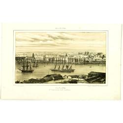
Habana. 2a Vista tomada desde Casa-Blanca.
Decorative view of Havana harbor, by Frederico Mialhe (1810-1881), with his signature on stone lower right. Lithographed by L. Marquier Ce de Lamparillo No. 96. From the ...
Date: Havana, 1838
Selling price: ????
Please login to see price!
Sold in 2010
Habana. 2a Vista tomada desde Casa-Blanca.
Decorative view of Havana harbor, by Frederico Mialhe (1810-1881), with his signature on stone lower right. Lithographed by L. Marquier Ce de Lamparillo No. 96. From the ...
Date: Havana, 1838
Selling price: ????
Please login to see price!
Sold in 2010