Please login to see price!.
Subscribe to be notified if similar examples become available.
Texas |
||||||||||||||||||||
|
||||||||||||||||||||
|
|
||||||||||||||||||||
|
Selling price: $...
Please login to see price! Sold in 2023 Missed this item! Be the first to get notified about our newly added listings. Add your name to our mailing list. Feel free to contact us if you have a question about this item. |
||||||||||||||||||||
Description
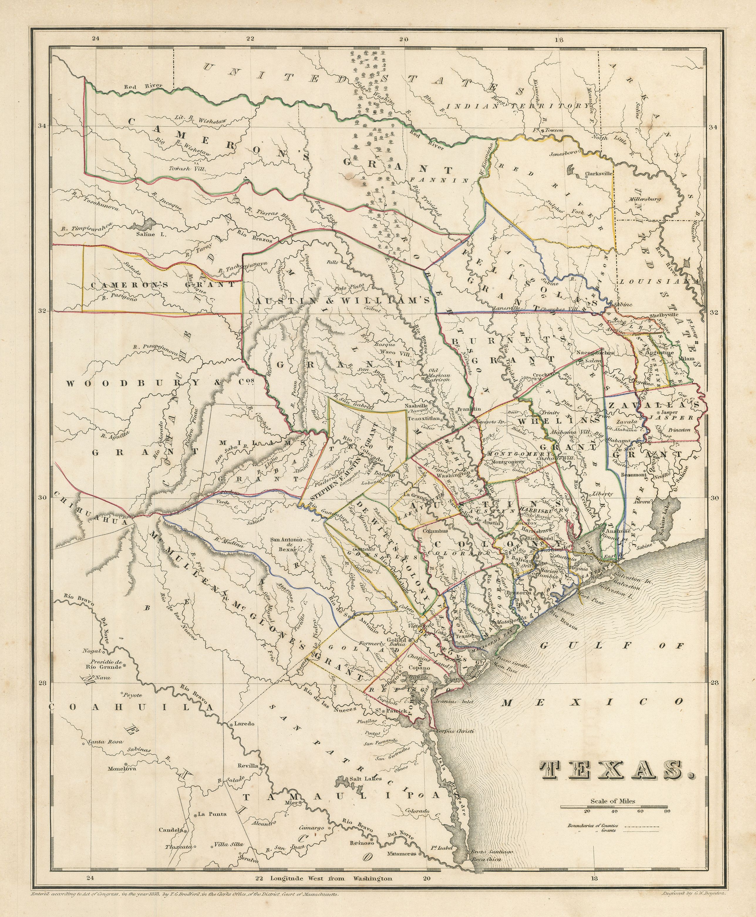
This is an important map of Texas during its time as a republic, showing the region as divided into land grants based on empresarios established by the Mexican government prior to the Texas Revolution. The map was published the same year Sam Houston became the President of the Republic of Texas and features some of the earliest Texan settlement, many of them with new names.
Though the date on the map suggest a publication of 1838, the map was actually published in 1841 as part of " A New Atlas of the World," by C.D. Strong out of Boston. Despite annual updates to his map, Bradford elected to save money and not legally register every state. While subtle difference can be found between each state of Bradford's map, the most important change found in the 1841 state is the extension of McMullen and McGlone's Grant to the Rio Bravo (Rio Grande). Prior maps of Texas as a republic limit the southern border to the Nueces River.
In 1828 John McMullen and James McGloin received a contract from Coahuila y Texas under the state colonization laws to settle 200 Irish families in an area located between the Nueces and Medina rivers. This spawned the town of St. Patrick and county (added in the 1841 state of Bradford's map) if San Patricio. This region was known to be filled with large heard of wild horses and was of great importance to both Mexicans and Texans. For years the Mexican government would dispute this concession and their reluctance to acknowledge the area a part of Texas would serve as one of the reasons for President James Polk to instigate the Mexican-American War.
FAQ - Guarantee - Shipping
Buying in the BuyNow Gallery
This item is available for immediate purchase when a "Add to Cart" or "Inquire Now" button is shown.
Payments are accepted in Euros or US Dollars. We accept most major credit cards, PayPal and bank transfer.
Authenticity Guarantee
 We provide professional descriptions, condition report and HiBCoR rating (based on 45 years experience in the map business)
We fully guarantee the authenticity of items we sell. We provide a certificate of authenticity for each purchased item.
Condition / Coloring
We indicate the condition of each item and use our unnique HiBCoR grading system in which four key items determine a map's value: Historical Importance, Beauty, Condition/Coloring and Rarity.
We offer many maps in their original black and white condition. We do not systematically color-up maps to make them more sellable to the general public or buyer.
Copper engraved or wood block maps are always hand colored. Maps were initially colored for aesthetic reasons and to improve readability. Nowadays, it is becoming a challenge to find maps in their original colors and are therefor more valuable.
We use the following color keys in our catalog:
Original colors; mean that the colors have been applied around the time the map was issued.
Colored; If the colors are applied recently or at the end of the 20th century, then "colored", or "attractive colors" will be used.
Original o/l colors; means the map has only the borders colored at the time of publication.
Read more about coloring of maps [+]
FAQ
Please have a look for more information about buying in the BuyNow gallery.
Many answers are likely to find in the general help section.
Collection
![]()
With Collection you can collect all your favorite items in one place. It is free, and anyone can create his or her virtual map collection.
Unless you are logged in, the item is only saved for this session. You have to be registed and logged-in if you want to save this item permanently to your collection.
Read More [+]
If you want to save the items permanently, please sign in
or create account first. ![]()
Registering Here, it is and you do not need a credit card.
Add this item to
Collection
or click the following link to see my Collection.
Invoice
The invoice and certificates of authenticity are available in the client center >Invoices
| Digital Image Download | |
|
Paulus Swaen maintains an archive of most of our high-resolution rare maps, prints, posters and medieval manuscript scans. We make them freely available for download and study. Read more about free image download |
Click the image for a free small image download. |
In accordance with the EU Consumer Rights Directive and habitually reside in the European Union you have the right to cancel the contract for the purchase of a lot, without giving any reason.
The cancellation period will expire 14 calendar days from the day after the date on which you or a third party (other than the carrier and indicated by you) acquires, physical possession of the lot. To exercise the right to cancel you must inform Paulus Swaen Inc, of your decision to cancel this contract by a clear statement (e.g. a letter sent by post, or e-mail (amsterdam@swaen.com).
To meet the cancellation deadline, it is sufficient for you to send your communication concerning your exercise of the right to cancel before the cancellation period has expired.
