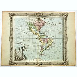
Browse Listings in America
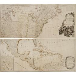
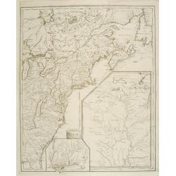
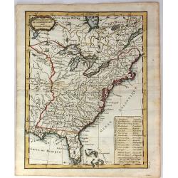
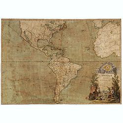
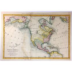
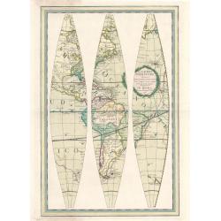
A new map of North America, with the West India Islands..
An important and grand map of the United States, printed on four joined sheets and at a very large-scale, extends to include all of known North America and the West Indie...
Date: London, 1763-1786
Selling price: ????
Please login to see price!
Sold
![[Untitled map of the Pacific and the Americas]](/uploads/cache/91430-250x250.jpg)
[Untitled map of the Pacific and the Americas]
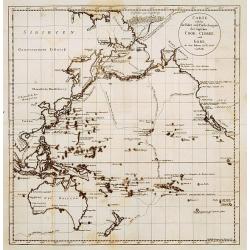
Large German map of the Pacific Ocean, showing the tracks of the three voyages of Captain Cook in great detail. Seems to be the right part of a larger map. Engraved by H....
Date: Vienna, ca. 1786
Selling price: ????
Please login to see price!
Sold in 2010
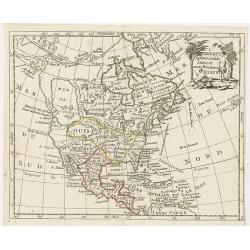
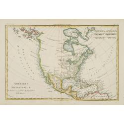
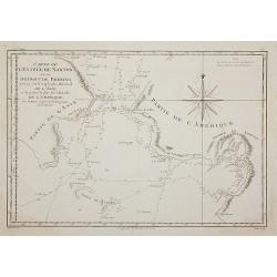
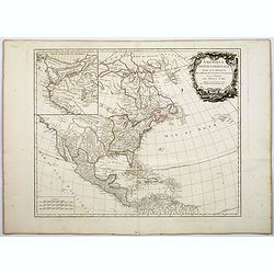
L'Amerique septentrionale divisee en ses principaux etats.
A scarce map of North America showing the principal American States and the possessions of Spain and France. Not in Mcguirk, Mer de l'OuestOf cartographic interest is the...
Date: Paris, 1786
Selling price: ????
Please login to see price!
Sold in 2021
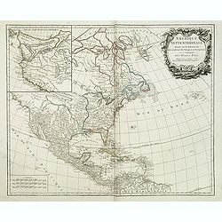
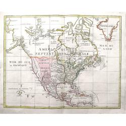
AMERIQUE SEPTENTRIONALE dressée sur les Relations les plus modernes des Voyageurs et Navigateurs ou se remarquent LES ETATS UNIS. . .
This large map of North America and the West Indies was originally published in 1750: however after the Treaty of Paris recognized the United States in 1783 the map was '...
Date: Paris, after 1786
Selling price: ????
Please login to see price!
Sold in 2011
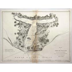
Plan of Port des Francais on the North West Coast of America in 58° 37' Latitude North and 139° 50 of Longitude West Discovered in July, 1786. . .
A fine copperplate chart of the 'Port des Francais' in Alaska. After reaching the northwest coast of America, at the height of Mount Saint-Elie, after one year of navigat...
Date: Paris, 1786
Selling price: ????
Please login to see price!
Sold in 2018
L'Amerique dressee pour l'etude de la geogrpahie. . .
A 1786 map of the North America and South America by French cartographer Louis Brion de la Tour. Showing the whole of North and South America with a number of interesting...
Date: Paris, 1786
Selling price: ????
Please login to see price!
Sold in 2021
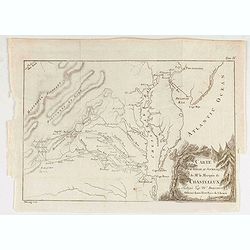
Carte Pour Servir Au Journal de Mr. Le Marquis de Chastellux Redigee par Mr. Dezoteux . . .
Chastellux's map of the Chesapeake region, including parts of Virginia, Maryland, Delaware & Pennsylvania. This map printed on thin paper shows Chastellux's route thr...
Date: Paris, 1786
Selling price: ????
Please login to see price!
Sold in 2021
Amerique Septentrionale.
Fine map of Northern and Central America, showing even part of the South American continent, prepared by R.Bonne and included in his Atlas Encyclopédique.. Rigobert Bonn...
Date: Paris 1787
Selling price: ????
Please login to see price!
Sold
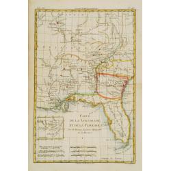
Carte de la Louisiane, et de la Floride.
Handsome map of the American Southeast and the Mississippi River Valley. The map extends from Charleston, South Carolina west to include New Orleans and north well into I...
Date: Paris 1787
Selling price: ????
Please login to see price!
Sold
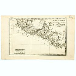
Partie Méridionale, de l'Ancien Méxique ou de la Nouv.le Espagne.
Copper engraved map of southern Mexico and all of Central America. Fine detail including shoals and navigational hazards along the coasts. Prepared by R.Bonne and include...
Date: Paris 1787
Selling price: ????
Please login to see price!
Sold
Carte de la Partie nord des Etats Unies de L'Amerique Sept..
Fine map of the east coast of America, including the Lakes Erie and Ontario, prepared by R.Bonne and included in his Atlas Encyclopédique.. Rigobert Bonne (1727-1795) wa...
Date: Paris 1787
Selling price: ????
Please login to see price!
Sold
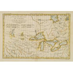
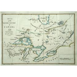
Partie Occidentale du Canada, contenant les cinq Grands Lacs?
Nice example of this map of the Great Lakes depicting frontier forts, missions, and fur trade routes. It covers the region from James Bay to just below Ft. Duquesne and f...
Date: Paris 1787
Selling price: ????
Please login to see price!
Sold
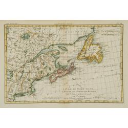
L'Isle de Terre-Neuve, l'Acadie, ou la Nouvelle Ecosse..
Fine map of the northwestern part of Canada, prepared by R.Bonne and included in his Atlas Encyclopédique.. Rigobert Bonne (1727-1795) was engineer, mathematician and ca...
Date: Paris 1787
Selling price: ????
Please login to see price!
Sold
Carte d'une partie de L'Amerique septentrionale..
The map was first published with a title Canada et Louisiane par le Sr. Le Rouge.. : during the Revolutionary War, Le Rouge reworked the plate and re-titled it Theatre de...
Date: Paris 1787
Selling price: ????
Please login to see price!
Sold
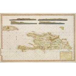
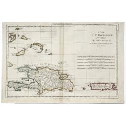
Carte reduite de L'Isle de Saint Domingue.
Very detailed chart made for the official French hydrographical office "Depot générale de la Marine". In top 4 coastal profiles.
Date: Paris, 1787
Selling price: ????
Please login to see price!
Sold
Carte Generale des Etats de Virginie, Maryland, Delaware, Pensilvanie, Nouveau-Jersey, New-York, Connecticut et Isle de Rhodes. Ainsi que des Lacs Erie, Ontario, et Champlain. D'Apres la Carte Ameriquaine de Louis Evans
Nice french map of the eastern part of the USA with the great lakes.
Date: Paris, 1787
Selling price: ????
Please login to see price!
Sold in 2013
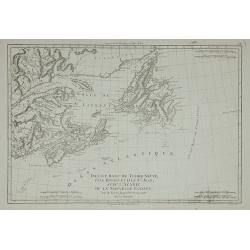
Isle et Banc de Terre-Neuve, Isle Royale et Isle St. Jean, ...
Detailed map of the region from Newfoundland to the Saint Lawrence and Nova Scotia, from Bonne's Atlas Supplement.
Date: Paris, 1787
Selling price: ????
Please login to see price!
Sold in 2011
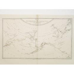
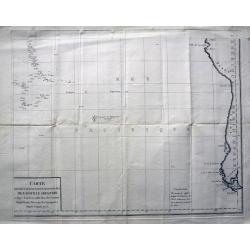
Carte de L'Entrée de Norton et du Détroit de Bhering, ...
The Bering Straits and Norton Sound, Alaska, showing the two attempts of Captain Cook's ship to penetrate the Straits on his third & final, fatal, voyage in 1778-79.
Date: Paris, 1787
Selling price: ????
Please login to see price!
Sold in 2011
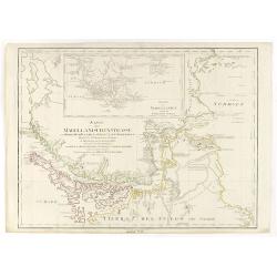
Karte der Magellanischen-Strasse. . .
Very detailed map of Strait of Magellan, with in top inset map of Southern tip of South America with the Falklands. Incorporating the discoveries of Herrn, Byron, Wallis,...
Date: Vienna, 1787
Selling price: ????
Please login to see price!
Sold in 2017
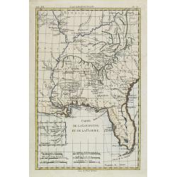
Carte de la Louisiane, et de la Floride.
Handsome map of the American Southeast and the Mississippi River Valley. The map extends from Charleston, South Carolina west to include New Orleans and north well into I...
Date: Paris, 1787
Selling price: ????
Please login to see price!
Sold
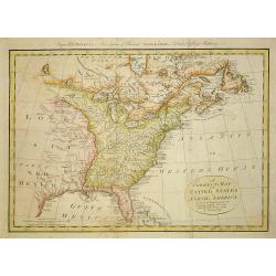
A correct map of the United States of North America..
Fine and uncommon map of the United States according to the treaty of 1784. Engraved for BANKE'S New System of Geography, Published by the Kings Royal Licence.Thomas Bowe...
Date: London, 1787
Selling price: ????
Please login to see price!
Sold in 2011
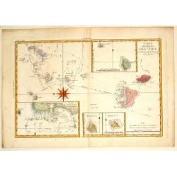
Carte des Isles des Amis.
Finely engraved chart depicts the Friedly Islands including the Kingdom of Tonga. The islands were discovered by Capatain Cook and his passage aboard the Resolution is ma...
Date: Paris, 1787
Selling price: ????
Please login to see price!
Sold in 2015
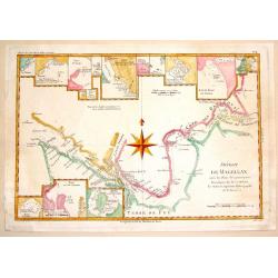
Detroit de Magellan.
A detailed engraved chart of the Straits of Magellan (between South America and Terra del Fuego), showing the best route through the dangerous straits. With 16 separate i...
Date: Paris, 1787
Selling price: ????
Please login to see price!
Sold in 2014
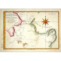
Carte de L'Entre de norton et du Detroit de Bhering.
Fine detailed map of the Behring Strait, the passage between Russia and Alaska. Includes the track of the voyage of Captain James Cook. Engraved and signed in engraving b...
Date: Paris, 1787
Selling price: ????
Please login to see price!
Sold in 2015
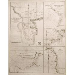
Plan de la Baye de l'Acul; Baye de Dame-Marie; Le Port François; Plan du Môle St. Nicolas; Baye des Irois
Five sea-charts on one large sheet. Engraved by Dela Haye for the Depot de la Marine. Each section shows depth soundings, anchoring places, and coastal information. A ra...
Date: Paris, 1787
Selling price: ????
Please login to see price!
Sold in 2014
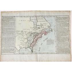
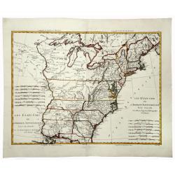
Etats-Unis de l' Amerique Seple. avec le Canada et la Floride
An attractive, early map of eastern United States and Canada decorated with a Baroque style title cartouche.Interestingly, North and South Carolina, plus Georgia, extend ...
Date: Paris, 1787
Selling price: ????
Please login to see price!
Sold in 2016
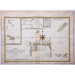
Isles de la Reine Charlotte.
Queen Charlotte Island map based on Captain Cook's voyages showing part of the Solomon Islands, located east of Papua New Guinea.The Isle du Lord Edgemont and Isle du Lor...
Date: Paris, 1787
Selling price: ????
Please login to see price!
Sold in 2017
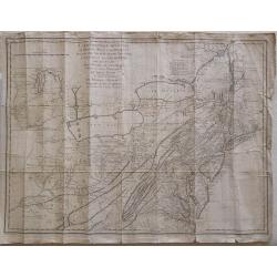
![[untitled map showing the route of the Continental Army from Boston to Yorktown]](/uploads/cache/40226-250x250.jpg)
[untitled map showing the route of the Continental Army from Boston to Yorktown]
Revolutionary War Battle map covering the East Coast of America from Boston Harbor to the Pamptico River in North Carolina. Its primary purpose is to depict the route of ...
Date: Paris, c. 1787
Selling price: ????
Please login to see price!
Sold in 2018
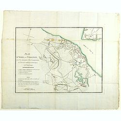
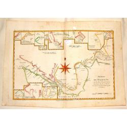
Plan d'York en Virginie, avec les attaques et les campemens de l'Armee combinee de France et d'Amerique
Map showing the battle of Yorktown, the final battle of the American Revolution, based upon French sources. The positions of the American, French and English forces and a...
Date: Paris, Buisson, 1787
Selling price: ????
Please login to see price!
Sold in 2020
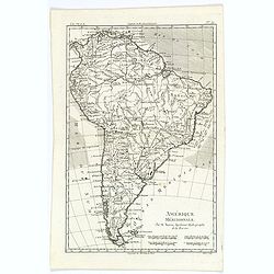
Amérique Méridionale.
A fine map of the South American continent, prepared by R.Bonne and included in his Atlas Encyclopédique. Plenty of good map detail, including hills, mountains, rivers p...
Date: Paris, 1787
Selling price: ????
Please login to see price!
Sold in 2020
L'Isle de St. Domingue et Celle de Porto-Rico.
A detailed map of Santa Domingo, Puerto Rico, etc. Includes substantial topographical detail. Includes Eastern Bahamas. From Bonne's "Atlas Supplement".Rigobert...
Date: Paris, 1787
Selling price: ????
Please login to see price!
Sold in 2019
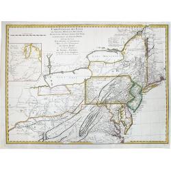
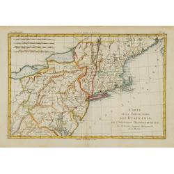
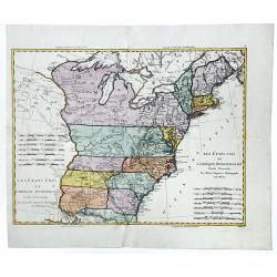
CARTE GENERALE DES ETATS de Virginie, Maryland, Delaware, Pensilvanie, Nouveau Jersey, New York, Connecticut et Isle de Rhodes. . .
A rare example of Louis Evans' important, first publication map of the Middle Colonies of 1755. Highlighted are Pensilvania and New Jersey. Engraved by Pierre Francois Ta...
Date: Paris, Tardieu, 1787
Selling price: ????
Please login to see price!
Sold in 2020
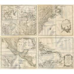
![[2 sheets] Carte de la Cote N.O. de l'Amerique et de la cote N.E. de l' Asie. / Carte de L'Entree de Norton et du Detroit de Bhering. . .](/uploads/cache/83615-250x250.jpg)
[2 sheets] Carte de la Cote N.O. de l'Amerique et de la cote N.E. de l' Asie. / Carte de L'Entree de Norton et du Detroit de Bhering. . .
A set of maps of the north Pacific with Alaska, engraved by André. They are after the general map of the Northwest Coast from the atlas volume of the first French editio...
Date: Paris, 1785-1787
Selling price: ????
Please login to see price!
Sold in 2020
Karte der Magellanischen Strasse.
Full title at center of the map: 'Karte der Magellanischen Strasse von Herrn Don Juan de la Cruz Canoy Olmedillo. Und nach den Beobachtungen der Herrn Byron, Wallis, Cart...
Date: Wien, 1787
Selling price: ????
Please login to see price!
Sold in 2021
Cartes de supplément pour les Isles Antilles.
An interesting map of the Antilles Islands including: Isles Vierges / Isle St Christophe / Isle Antigoa / Isle de la Dominique / Isle Ste Lucie / Isle de la Barbade / Isl...
Date: Paris, 1787
Selling price: ????
Please login to see price!
Sold in 2023
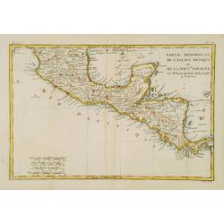
Partie Méridionale, de l'Ancien Méxique ou de la Nouvelle Espagne.
A copper engraved map of southern Mexico and all of Central America. Fine detail including shoals and navigational hazards along the coasts. Four sets of mileage scales g...
Date: Paris, 1787
Selling price: ????
Please login to see price!
Sold in 2020
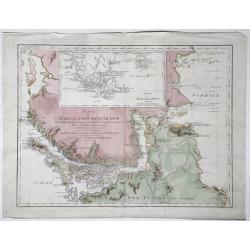
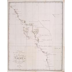
![L' Ancien et le nouveau Mexique, avec la Floride et la basse Louisiane.. [Texas,California]](/uploads/cache/84796-250x250.jpg)
L' Ancien et le nouveau Mexique, avec la Floride et la basse Louisiane.. [Texas,California]
Fine map on 2 joined sheets, of the southern United States [Florida, Louisiana, Texas, New Mexico and California , further on Mexico, the Central American States, and the...
Date: Paris 1787
Selling price: ????
Please login to see price!
Sold in 2021
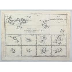
![[Virgin Islands] Cartes De Supplement Pour Les Isles Antilles.](/uploads/cache/85495-250x250.jpg)
[Virgin Islands] Cartes De Supplement Pour Les Isles Antilles.
An excellent map of the Virgin Islands from Puerto Rico to Barbuda, centered on the American and British V.I., extending from Crab Island, St. Thomas and St. Croix to Sab...
Date: Paris, 1787
Selling price: ????
Please login to see price!
Sold in 2022
DES POSSESSIONS FRANCOIS AUJOURD'HUI SOUS LA DOMINATION ANGLOIFES.
An interesting, decorative map from Labrador and the Hudson Bay area in Canada to the Gulf of Mexico. Inland as far as the Lake of the Woods and the Great Plains. French ...
Date: Paris, 1787
Selling price: ????
Please login to see price!
Sold in 2022
Karte von den N.W.Amerikanische und N.O.E. Asia..
German edition of Cook's explorations along the NW Coast of America and NE Coast of Asia, based upon the original work by Lieutenant Henry Roberts.A detailed large-scale ...
Date: Vienna 1788
Selling price: ????
Please login to see price!
Sold in 2008
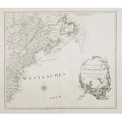
Generalkarte von Nord America samt den Westindischen Inseln . . .
Map of the North American coastal states from New Scotland to Pennsylvania. Sheet 20 of Schraembl's "Allgemeiner Grosser Atlas", this is one of the first maps i...
Date: Vienna, 1788
Selling price: ????
Please login to see price!
Sold in 2020
![[Map of North West America with Great Lakes region.]](/uploads/cache/26129-250x250.jpg)
[Map of North West America with Great Lakes region.]
Map of New Mexico, Louisiana, parts of Georgia, North Carolina and the Michigan lakes. Inset map of Baffin and Hudson Bay.Sheet 21 of Schraembl's "Allgemeiner Grosse...
Date: Vienna, 1788
Selling price: ????
Please login to see price!
Sold in 2017

Pirogue du port des français. / Pirogue, trouvée au port des français.
From Atlas du Voyage de la Pérouse.Lituya Bay is a fjord located on the coast of the Southeast part of the U.S. state of Alaska. The bay was noted in 1786 by Jean-Franç...
Date: Paris, 1788
Selling price: ????
Please login to see price!
Sold in 2010
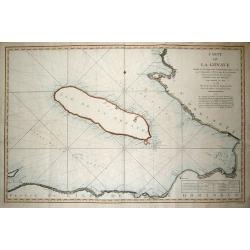
CARTE DE LA GONAVE...
Fantastic large-scale chart of the island of Gonave. Includes also the coasts of Haiti, with Saint-Marc, Port-au-Prince, Leogane, Petit and Grand Goave. Filled with numer...
Date: Paris, 1788
Selling price: ????
Please login to see price!
Sold in 2013
Carte des déclinaisons et inclinaisons de l'aiguille aimantée...1775
Large sea-chart of the south Pacific, indicating the magnetic variations of the compass needle. Includes the coast of South America and extends to include Tahiti. An int...
Date: Paris, 1788
Selling price: ????
Please login to see price!
Sold in 2013
Detroit de Magellan avec les Plans des Pricipaux, Ports, Baves & de ce Detroit.
Interesting hand-colored, copperplate map of The Straits of Magellanshowing the direction of the currents, bays, points, soundings, harbours, islands, shoals etc. Large c...
Date: Paris, 1788
Selling price: ????
Please login to see price!
Sold in 2015
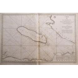
Carte de la Gonave...
Fantastic large-scale sea-chart of the island of Gonave. Includes also the coasts of Haiti, with Saint-Marc, Port-au-Prince, Leogane, Petit and Grand Goave. Highly detail...
Date: Paris, 1788
Selling price: ????
Please login to see price!
Sold in 2014
L' Amérique divisée en tous ses pays suivant, les nouvelles observations des plus celébres navigateurs. . . 1788
Rare wall map of the Americas and the north-west part of Africa, published by Jean and Louis Joseph Mondhare. Only mentioned by Tooley as a single chart with the one date...
Date: Paris: Mondhare et Jean, 1788
Selling price: ????
Please login to see price!
Sold in 2023
![Untitled [Virginia Land Grant With Manuscript Map]](/uploads/cache/36846-250x250.jpg)
Untitled [Virginia Land Grant With Manuscript Map]
A fascinating item of colonial ephemera, this land grant printed on vellum with hand-written infill includes a manuscript map of the 2000 acres, set within a rectangular ...
Date: Richmond, Virginia 1788
Selling price: ????
Please login to see price!
Sold in 2016
LES ETATS UNIS DE L' AMERIQUE SEPTENTRIONALE. Partie Occidentale.
A detailed map of the region bounded by New England, Florida, Mississippi river, Louisiana and Great Lakes of Canada. Includes towns, mountains, rivers, lakes, Indians, F...
Date: Paris, 1788
Selling price: ????
Please login to see price!
Sold in 2019
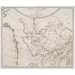
General Karte von Nord America samt den Westindischen Inseln Verfasst von Herrn Pownall.
A monumental map of North America, depicted shortly after the American Revolution. Printed on four sheets, not joined. Insets: Baffin & Hudson Bay. Engraver: J. Steng...
Date: Wien, 1788
Selling price: ????
Please login to see price!
Sold in 2019
Les Etats-Unis de L'Amerique Septentrionale.
A detailed map of the region bounded by New England, Florida, Mississippi river, Louisiana and the Great Lakes of Canada. Includes towns, mountains, rivers, lakes, Indian...
Date: Paris, 1788
Selling price: ????
Please login to see price!
Sold in 2020
Carte de L'Isle de Sainte Lucie. Dressee au Depost des Cartes et Plans de la Marine. . .
A well engraved and highly detailed nautical chart of the island of Saint Lucia in Caribbean. It shows soundings, anchorage's, channels, shoals, navigational sightings. U...
Date: Paris, 1788
Selling price: ????
Please login to see price!
Sold in 2021
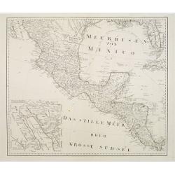
No title: Mexico & Central America.
A scarce Austrian map based on the important Bowen & Gibson map of North America and the West Indies (Sayer & Bennett 1783 edition). Covers Mexico southward from ...
Date: Vienna 1789
Selling price: ????
Please login to see price!
Sold

La destruction de la Statue royale a Nouvelle York.
One of the few European prints dealing with the Revolutionary war.J. Chereau was a publisher of optical print, established in Paris, rue St.Jacques. In the eighteenth and...
Date: Paris, 1790
Selling price: ????
Please login to see price!
Sold
Carte welche die fahrt und Entdeckungen des Capitäns COOK, CLERKE, und GORE, in dem Jahren 1776_1780 vorstellt.
Showing the Pacific, with the tracks of Cook in 1777, Captain Clarck in 1779 and Captain Gore 1779.
Date: Germany c.1790
Selling price: ????
Please login to see price!
Sold
L' America.
A small map depicting the Americas, from the Italian edition of Claude Buffier's 'Geographie Universelle'.
Date: Venice, 1790
Selling price: ????
Please login to see price!
Sold
![[No title] Kamtschatskisches Meer.](/uploads/cache/21312-250x250.jpg)
[No title] Kamtschatskisches Meer.
Engraved by S. V.Dorn. Early map of Alaska.
Date: Germany 1790
Selling price: ????
Please login to see price!
Sold

Uomo del Brasile. / Homme du Brasil.
Full portrait of a Brazilian hunter. From "Raccolta di ? stampe." a series of historically significant eighteenth-century copper plate engravings by Venetian en...
Date: Venice, Antonio Zatta, c.1790
Selling price: ????
Please login to see price!
Sold in 2013
A Chart of the Interior part of North America demonstrating the very great possibility of an Island of Navigation from Hudson's Bay to the West Coast
Rare and curious map of a supposed "Northwest Passage" from the Hudson Bay into the Pacific Ocean. Based upon the explorations of John Meares in 1788 and 1789....
Date: London, 1790
Selling price: ????
Please login to see price!
Sold in 2009
Canada, Louisiane, États-Unis.
Uncommon third state with changed title cartouche and corrigés par le Cen.Lamarche son successeur added to title.Two maps on one sheet. The map of the western part of No...
Date: Paris, 1790
Selling price: ????
Please login to see price!
Sold in 2010
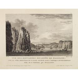
Vue Des Montagnes Escarpées De Fraisler, Sur La Côte Orientale De La Baye George Dans L'Amérique Septentrionale. Atlas de ce Continent, par Desbares.
Fine view of St. Georges Bay, Nova Scotia, east coast of Canada. '12.' inscribed upper right. Engraved by Pillement. "A Paris, chez Noel, Md. D'Estampes, Rue St. Jac...
Date: Paris, ca. 1790
Selling price: ????
Please login to see price!
Sold in 2021
Nouveau Mexique, Louisiane, Canada. . .
Map showing United States and Canada. Left and right a box with geographical information for each part country on the continent.Prepared by Louis Brion de la Tour and pub...
Date: Paris, 1790
Selling price: ????
Please login to see price!
Sold in 2016

La destruction de la Statue royale a Nouvelle York.
One of the few European prints dealing with the Revolutionary war.J. Chereau was a publisher of optical prints, established in Paris, rue St.Jacques. In the eighteenth an...
Date: Paris, 1790
Selling price: ????
Please login to see price!
Sold in 2012

Hémisphére Occidental.
Map of Western hemisphere.Left and right a box with geographical information for spheres of different types.Prepared by Louis Brion de la Tour and published by Louis Char...
Date: Paris, 1790
Selling price: ????
Please login to see price!
Sold in 2020
A New & Accurate Map of North America: With the New Discovered Islands on the North East coast of Asia
This fine map focuses on the discoveries of Captain Cook in the Pacific Northwest and Alaska. Alaska is fairly well formed but misshapen, although much of the Aleutian Is...
Date: London, 1790
Selling price: ????
Please login to see price!
Sold in 2016
![[de Lafayette, full-length portrait] Conclusion de la campagne -- de 1781 en Virginie Liberté : To his Excellency General Washington this Likeness of his friend, the Marquess de la Fayette, is humbly dedicated, By le Mire. . .](/uploads/cache/36866-250x250.jpg)
[de Lafayette, full-length portrait] Conclusion de la campagne -- de 1781 en Virginie Liberté : To his Excellency General Washington this Likeness of his friend, the Marquess de la Fayette, is humbly dedicated, By le Mire. . .
Print shows Marquis de Lafayette, full-length portrait, standing, facing front, wearing a uniform, and holding two swords in the left hand while directing American troops...
Date: Paris, 1780 - 1790
Selling price: ????
Please login to see price!
Sold in 2016
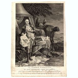
Le Général Washington ne quid detrimenti capiat res publica - gravé d'après le tableau original appartenant a Mr. Marquis de la Fayette. . .
Print shows George Washington, full-length portrait, standing outside tent, wearing military uniform, holding the Declaration of Independence and the treaty of alliance w...
Date: Paris, 1780 - 1790
Selling price: ????
Please login to see price!
Sold in 2016
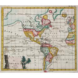
Amerique Septentrionale. . .
An interesting, and important map by the French cartographer, Robert de Vaugondy. A map of the United States beginning in the High Arctic and Baffin Bay, and then southwa...
Date: Paris, ca 1790
Selling price: ????
Please login to see price!
Sold in 2018
Amerique Septentrionale.
A large and scarce map of North America, including the recently discovered Sandwich Islands. With unusual areas, including a huge New Mexico and Louisian. Also a large pa...
Date: Augsburg, ca 1790
Selling price: ????
Please login to see price!
Sold in 2020
Indes Occidentales.
An antique map of the West Indies centered around Cuba with the Caribbean islands, Mexico and parts of North and South America.Jacques Blondeau (1766-1841) was a French c...
Date: Paris, ca 1790
Selling price: ????
Please login to see price!
Sold in 2023
CARTE de la Partie Meridionale des ETATS-UNIS.
A nice example of this scarce and highly detailed map of the southern United States, showing excellent topography, roadways, and a great many place names and Indian tribe...
Date: Paris, 1790
Selling price: ????
Please login to see price!
Sold in 2019
Nouveau Mexique, Louisiane, Canada..
A lovely 1786 map of North America by Desnos and Brion de la Tour. It shows North America according to the French with a northwest passage extending west from Labrador an...
Date: Paris, 1790
Selling price: ????
Please login to see price!
Sold in 2020
Kaart van het Zuidlyk Eind van Amerika. 1775.
An uncommon Dutch chart of the tip of South America, showing Patagonia, Tierra del Fuego and the Falkland Islands. With an inset of Staaten Land in the lower right corner...
Date: Amsterdam ca 1790
Selling price: ????
Please login to see price!
Sold in 2020
![[Lot of 11 maps of the Strait of Magellan] Carte du detroit de Magellan avec les Routes de la Bodeuse et de l'Etoile.](/uploads/cache/19991-(3)-250x250.jpg)
[Lot of 11 maps of the Strait of Magellan] Carte du detroit de Magellan avec les Routes de la Bodeuse et de l'Etoile.
Carte du Detroit de Magellan avec les Routes de la Bodeuse et de l'Etoile taken by the French discoverer Comte de Bougainvile, L.A. With in addition 10 maps / prints of...
Date: Paris, c. 1790
Selling price: ????
Please login to see price!
Sold in 2022
Globo Terrestre Delineato sulle ultime osservazioni con i viaggi e nuove scoperte del Cap. Cook, inglese
One of four sheets that make up Cassini's terrestrial globe of 1790 which measured 34cm in diameter and delineated the tracks of all three of Captain Cook’s voyages, a...
Date: Rome, 1790
Selling price: ????
Please login to see price!
Sold in 2023

A Man of Prince William's Sound / A Woman of Prince William's Sound.
A pair of copperplate engravings of a man and a woman from Prince William's Sound in Gulf of Alaska - taken rom drawings by John Webber from John Hawkesworth's account of...
Date: London, ca 1790
Selling price: ????
Please login to see price!
Sold in 2023
Karte des nördlichsten America..
Rare 18th Century map covering the NW Coast of America South to Cape Mendocino, the Missouri River and the Ohio River and extending North to the include the Bering Strait...
Date: Berlin 1791
Selling price: ????
Please login to see price!
Sold
Entwurf der neuesten.. Nordwestküste von America.
Shows the most recent discoveries at the Northwest Coast of America according to Hanna, Johnstone, Wedgborough, Portlock, Dixon, Duncan, Meares and de la Quandra. Include...
Date: Falk 1791
Selling price: ????
Please login to see price!
Sold
Sketch of the Western countries of Canada 1791./ Westliches Canada.
Rare map of the Great Lakes region up to James Bay. After a design by C.Reichard and engraved by Brauns. Published in See und Land-Reisen, by B.Gottlob Hoffmann.
Date: Hamburg 1791
Selling price: ????
Please login to see price!
Sold