Browse Listings in America
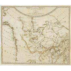
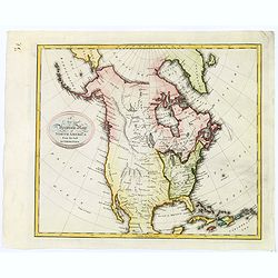
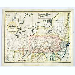
Karte des nördlichsten America..
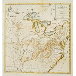
Rare 18th Century map covering the NW Coast of America South to Cape Mendocino, the Missouri River and the Ohio River and extending North to the include the Bering Strait...
Date: Berlin 1791
Selling price: ????
Please login to see price!
Sold
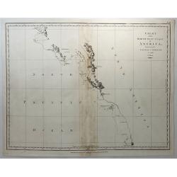
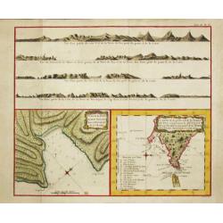
Chart of the North West Coast of America Explored by the Bousole & Astrolabe in 1786. (2nd Sheet)
A fine copperplate chart of the northwest coast of America from Mount La Touche to Cape Redondo. From La Perouse’s ATLAS DU VOYAGE DE LA PEROUSE. Published by G.G &...
Date: London, 1791
Selling price: ????
Please login to see price!
Sold in 2018
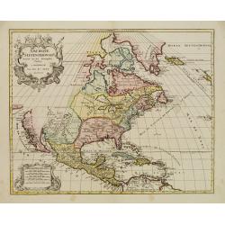
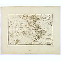
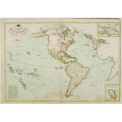
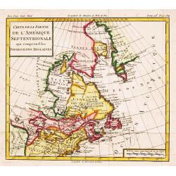
Amerique Septentrionale..
Richly embellished map of North America. Based on the Sanson map, which was the first to include all five Great Lakes. California now attached to the mainland. With a lar...
Date: Amsterdam 1792
Selling price: ????
Please login to see price!
Sold
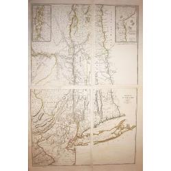
Province de New-York en 4 Feuilles par Montresor.
The Le Rouge edition of the most important map of New York Province in the Revolutionary War period. Spectacular map in four sheets of New York. The map shows the adminis...
Date: Paris, 1777-1792
Selling price: ????
Please login to see price!
Sold in 2009
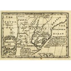
Paraguay and Tucuman.
Uncommon miniature map from Gibson's "Atlas Minimus, or a New Set of Pocket Maps of the several Empires, Kingdoms and States of the known World".
Date: London, 1792
Selling price: ????
Please login to see price!
Sold in 2011
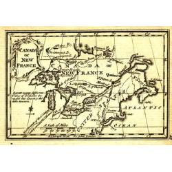
Canada or New France.
Uncommon miniature map from Gibson's "Atlas Minimus, or a New Set of Pocket Maps of the several Empires, Kingdoms and States of the known World".
Date: London, 1792
Selling price: ????
Please login to see price!
Sold in 2011
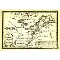
The United States of America.
Uncommon miniature map from Gibson's "Atlas Minimus, or a New Set of Pocket Maps of the several Empires, Kingdoms and States of the known World".
Date: London, 1792
Selling price: ????
Please login to see price!
Sold in 2011
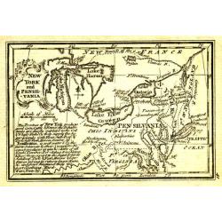
New York and Pensilvania.
Uncommon miniature map from Gibson's "Atlas Minimus, or a New Set of Pocket Maps of the several Empires, Kingdoms and States of the known World".
Date: London, 1792
Selling price: ????
Please login to see price!
Sold in 2011
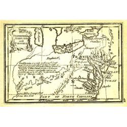
Pensilvania, Maryland and Virginia.
Uncommon miniature map from Gibson's "Atlas Minimus, or a New Set of Pocket Maps of the several Empires, Kingdoms and States of the known World".
Date: London, 1792
Selling price: ????
Please login to see price!
Sold in 2011
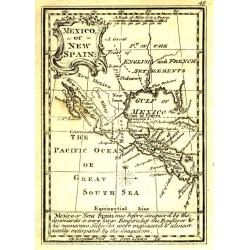
Mexico or New Spain.
Uncommon miniature map from Gibson's "Atlas Minimus, or a New Set of Pocket Maps of the several Empires, Kingdoms and States of the known World".
Date: London, 1792
Selling price: ????
Please login to see price!
Sold in 2011
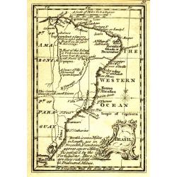
Brasil.
Uncommon miniature map from Gibson's "Atlas Minimus, or a New Set of Pocket Maps of the several Empires, Kingdoms and States of the known World".
Date: London, 1792
Selling price: ????
Please login to see price!
Sold in 2011
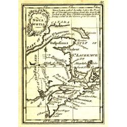
Nova Scotia.
Uncommon miniature map from Gibson's "Atlas Minimus, or a New Set of Pocket Maps of the several Empires, Kingdoms and States of the known World".
Date: London, 1792
Selling price: ????
Please login to see price!
Sold in 2011
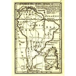
South America.
Uncommon miniature map from Gibson's "Atlas Minimus, or a New Set of Pocket Maps of the several Empires, Kingdoms and States of the known World".
Date: London, 1792
Selling price: ????
Please login to see price!
Sold in 2011
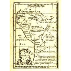
Peru.
Uncommon miniature map from Gibson's "Atlas Minimus, or a New Set of Pocket Maps of the several Empires, Kingdoms and States of the known World".
Date: London, 1792
Selling price: ????
Please login to see price!
Sold
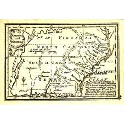
Carolina and Georgia.
Uncommon miniature map from Gibson's "Atlas Minimus, or a New Set of Pocket Maps of the several Empires, Kingdoms and States of the known World".
Date: London, 1792
Selling price: ????
Please login to see price!
Sold in 2011
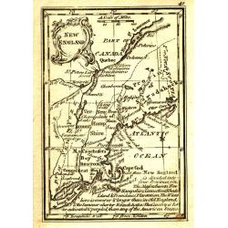
New England.
Uncommon miniature map from Gibson's "Atlas Minimus, or a New Set of Pocket Maps of the several Empires, Kingdoms and States of the known World".
Date: London, 1792
Selling price: ????
Please login to see price!
Sold in 2011
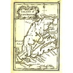
Island of Cape Breton.
Uncommon miniature map from Gibson's "Atlas Minimus, or a New Set of Pocket Maps of the several Empires, Kingdoms and States of the known World".
Date: London, 1792
Selling price: ????
Please login to see price!
Sold in 2011
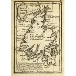
New-Found Land.
Uncommon miniature map from Gibson's "Atlas Minimus, or a New Set of Pocket Maps of the several Empires, Kingdoms and States of the known World".
Date: London, 1792
Selling price: ????
Please login to see price!
Sold
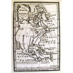
North America.
Uncommon miniature map from Gibson's "Atlas Minimus, or a New Set of Pocket Maps of the several Empires, Kingdoms and States of the known World".
Date: London, 1792
Selling price: ????
Please login to see price!
Sold in 2011
L'Amerique Septentrionale et Meridionale Divisee Suivant ses Differens Pays...
Detailed four sheet wall map of America, first published by Robert De Vaugondy circa 1760.In North America, a large "Quivara et Teguaio" occupies the west along...
Date: Paris, 1792
Selling price: ????
Please login to see price!
Sold in 2017
A New and Accurate Map of North America from the best Authorities.
A scarce map of North America, from Brown's 'General Atlas', engraved by Menzies. It shows a 'River of the West', extending from the Juan De Fuca entrance to the R. Orega...
Date: Edinburgh, 1792
Selling price: ????
Please login to see price!
Sold in 2020
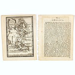
North America.
Uncommon miniature map from Gibson's "Atlas Minimus, or a New Set of Pocket Maps of the several Empires, Kingdoms and States of the known World". Together with ...
Date: London, 1792
Selling price: ????
Please login to see price!
Sold in 2017
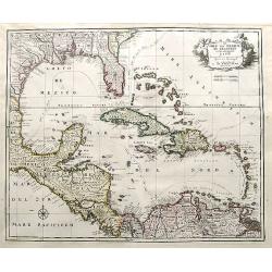
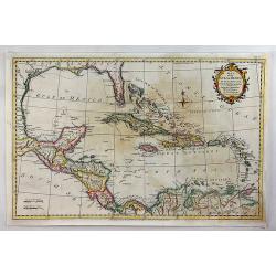
De Golf van Mexico de eilanden en het omleggende land. . .
A large map of the Gulf of Mexico and the Caribbean including the coasts of the US, Central America and the north of South America. Ii includes interesting shapes of the ...
Date: Amsterdam, 1792
Selling price: ????
Please login to see price!
Sold in 2018
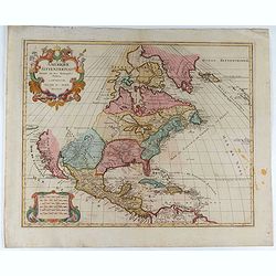
Amerique Septentrionale . . .
Richly embellished map of North America. Based on the Sanson map, which was the first to include all five Great Lakes. California now attached to the mainland. With a lar...
Date: Amsterdam, 1792
Selling price: ????
Please login to see price!
Sold in 2020
Western Part of the Territories.
A Map of the western part of the territories belonging to the United States of America. Engraved for Imlay's Topographical Description of that Country . Engraved by T. Co...
Date: London 1793
Selling price: ????
Please login to see price!
Sold
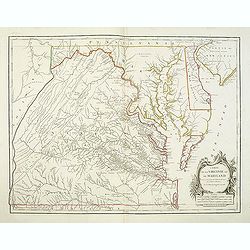
Carte De La Virginie Et Du Maryland Dressee sur la grande carte Angloise de Mrs. Josue Fry et Pierre Jefferson . . . 1755
A state five (of 5). Showing pre-revolutionary war Virginia and Maryland, extending west to the Alleghany Mountains, and including Delaware and a portion of New Jersey, ...
Date: Paris, ca.1793
Selling price: ????
Please login to see price!
Sold in 2013
RUSSIAN TEXT MAP - NORTH AMERICA.
A rare Russian, copper engraved map of north America. Based on the second state of the Janvier/Lattre map. It includes the results of Captain Cooks discoveries on America...
Date: St.Petersburg, 1793
Selling price: ????
Please login to see price!
Sold in 2021
RUSSIAN TEXT MAP - CANADA.
A rare Russian map of western Canada. Based on the Janvier/Lattre map. This Cyrillic version of the map appeared in one of the first world atlases published in Russia; &q...
Date: St.Petersburg, 1793
Selling price: ????
Please login to see price!
Sold in 2021
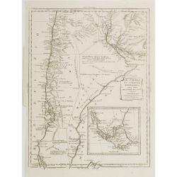
Il Chili lo Stretto Magellanico coll' Isola della Terra del Fuoco.
A finely engraved copper plate map that covers Chili and most of Argentina. Good detail of the region around Buenos Ayres and the Rio de la Plata. Santiago here is named ...
Date: Venise 1794
Selling price: ????
Please login to see price!
Sold
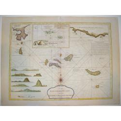
Chart of the Acores (Hawks) Islands, called also the Flemish and Western Islands
This is a fine, handsome nautical chart showing all the Azores islands with currents, rumb lines, anchorages, etc. Relief is shown by hachures, Includes 6 coastal profile...
Date: London, ca. 1794
Selling price: ????
Please login to see price!
Sold
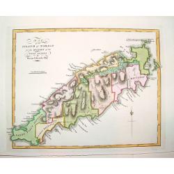
Map of the Island of Tobago for the History of the West Indies by Bryan Edwards Esqr.
A superbly engraved, seldom seen map of the island of Tobago. The work offers nice topographical detail and identifies all the island's land divisions, as well as major t...
Date: London, ca. 1794
Selling price: ????
Please login to see price!
Sold in 2008
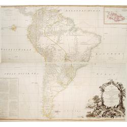
A map of South America containing Terra-Firma.. Brasil.. Patagonia..
A large wall map of south America. Impressive title cartouche lower right and a large text block lower left : "Division of South America with a summary account of it...
Date: London,1794
Selling price: ????
Please login to see price!
Sold in 2013
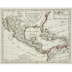
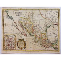
Nouvelle Espagne, Nouvaeu Mexique, Isles Antiles.
Published by Charles Lamarche. Showing the most notable areas of New Spain in North, South and Central America from Nouveau Mexique to Terre Ferme as well as the Caribbea...
Date: Paris, 1794
Selling price: ????
Please login to see price!
Sold in 2011
Il Chili lo Stretto Magellanico coll' Isola della Terra del Fuoco.
A finely engraved copper plate map that covers Chili and most of Argentina. Good detail of the region around Buenos Ayres and the Rio de la Plata. Santiago here is named ...
Date: Venise, 1794
Selling price: ????
Please login to see price!
Sold in 2009
Il Chili lo Stretto Magellanico coll' Isola della Terra del Fuoco.
A finely engraved copper plate map that covers Chili and most of Argentina. Good detail of the region around Buenos Ayres and the Rio de la Plata. Santiago here is named ...
Date: Venise, 1794
Selling price: ????
Please login to see price!
Sold in 2011
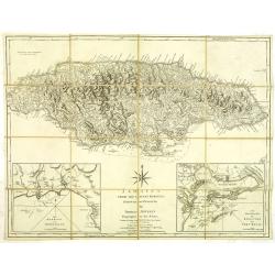
Jamaica from the latest surveys, improved and engraved by Thomas Jefferys. . .
Detailed map of Jamaica, showing parishes, towns and villages, churches, forts, roads, rivers and ponds, harbors, anchorages, soundings, etc.Includes an annotation at upp...
Date: London, 1794
Selling price: ????
Please login to see price!
Sold in 2012
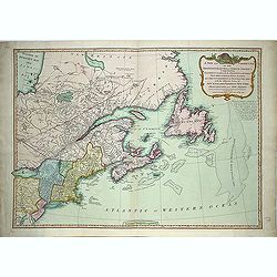
A new and correct map of the British Colonies in North America. . .
Famous map prepared by Gov. Pownall Major Holland. Northern British Colonies, Quebec, New Foundland, Nova Scotia, New England, New York. Including Hudson and James Bays, ...
Date: London, 1794
Selling price: ????
Please login to see price!
Sold in 2013
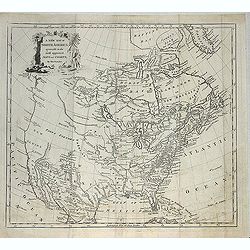
A new map of North America agreeable to the most approved maps and charts. . .
Detailed and uncommon map of North America with the Northwest labeled These Parts Are Entirely Unknown and Land discovered by de L'Isle 1741. Engraved by T.Condor and pub...
Date: London, 1794
Selling price: ????
Please login to see price!
Sold in 2013
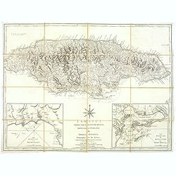
Jamaica from the latest surveys, improved and engraved by Thomas Jefferys. . .
Detailed map of Jamaica, showing parishes, towns and villages, churches, forts, roads, rivers and ponds, harbors, anchorages, soundings, etc.Includes an annotation at upp...
Date: London, 1794
Selling price: ????
Please login to see price!
Sold in 2018
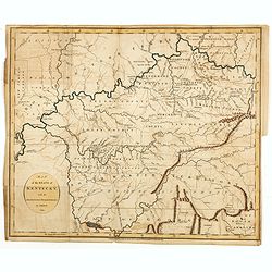
Map of the State of Kentucky with the Adjoining Territory By J. Russell 1794.
Important early map of Kentucky, showing primarily the region around the Ohio and Tennessee Rivers, from northern Georgia to Western Territory. Prepared by John Russell (...
Date: London, H.D. Symonds, 1794
Selling price: ????
Please login to see price!
Sold
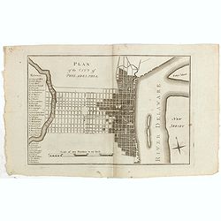
Plan of the city of Philadelphia.
Rare plan of Philadelphia with a lettered key to the important buildings (A. Congress Hall, B. State House C. City Hall, (. . .) W. Bank U.S. X. Bank Penn. Y. Bank N.A., ...
Date: Philadelphia, 1794
Selling price: ????
Please login to see price!
Sold in 2015
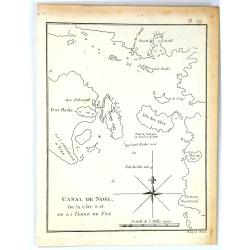
Canal de Noël sur la côte S.O. de la Terre de Feu.
A simple map of Christmas Sound from James Cook’s voyages. Cook reached Christmas Sound near Tierra del Fuego on 25th & 26th December 1774, returning to England on ...
Date: London, 1794
Selling price: ????
Please login to see price!
Sold in 2016
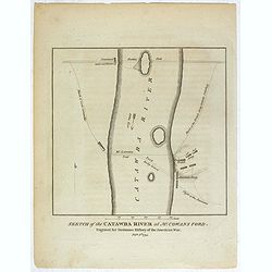
Sketch of the Catawba River at McCowan's Ford. . .
Revolutionary War battle plan, showing Lord Cornwallis' march and crossing of the Catawba River at McCown's Ford (now Cowan's Ford), and on towards Salisbury, along with ...
Date: London, 1794
Selling price: ????
Please login to see price!
Sold in 2018
Map of the Middle States of America, comprehends New-York, New-Jersey, Pennsylvania, Delaware, and the Territory N.W. of Ohio.
An interesting map of the region of the United States extending from New Jersey to Indiana, and from northern New York to Maryland. Detail in the east is plentiful, with ...
Date: London, 1794
Selling price: ????
Please login to see price!
Sold in 2017
America North and South and the West Indies, with the Atlantic, Aethiopic and Pacific Oceans. . .
A Laurie and Whittle produced map of Samuel Dunn's earlier work of the Americas from A New Atlas of the Mundane System, or of Geography and Cosmography. Of particular int...
Date: London, 1794
Selling price: ????
Please login to see price!
Sold in 2018

The Coast of Yucatan from Campeche to Ascension Bay with the West End of Cuba, ...
Double page sea chart showing the Yucatan Peninsula to the lower edge, the western tip of Cuba shown to the right edge. A quartered compass rose shown to lower right corn...
Date: London, Laurie and Whittle. 1794
Selling price: ????
Please login to see price!
Sold in 2020
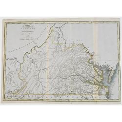
The State of Virginia from the best authorities, by Samuel Lewis. 1794.
Very detailed map of Virginia, prepared by Samuel Lewis.Engraved by Smithier and included in Carey's American Edition of Gurthries Geography.Underneath the map "engr...
Date: Philadelphia, Mathew Carey, 1795
Selling price: ????
Please login to see price!
Sold

George Washington.
Very fine steel engraving of George Washington.
Date: Amsterdam 1795
Selling price: ????
Please login to see price!
Sold
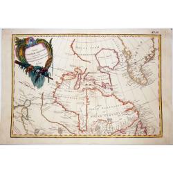
Carte de L'Amérique Septentrionale et Méridionale ou se trouvent les Découvertes les plus nouvelles..
Rare map of Asia, prepared by Hérisson after R.Bonne. Showing the tracks of Captain James Cook. Insets with the islands of Martinique and St. Domingue (Haïti)
Date: Paris 1795
Selling price: ????
Please login to see price!
Sold
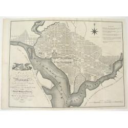
PLAN OF THE CITY OF WASHINGTON, IN THE TERRITORY OF COLUMBIA...
An important and very rare, state one example of the first British printing of Washington D.C. The plan derives from John Reid's, The American Atlas. The source for both...
Date: London, 1795
Selling price: ????
Please login to see price!
Sold
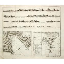
Carte de la Baye du Bon Succès dans le Détroit de le Maire./ Carte de la partie S.E. de la Terre de Feu comprenant le Détroit de le Maire et une part.ie de la Terre des Etats. 1769.
Captain James Cook (1728-79), explorer, circumnavigator and hydrographer. Three voyages, 1768-71, 1772-75 and 1776-79. From 1778 on printed editions of ' Captain Cook's T...
Date: Paris, c. 1795
Selling price: ????
Please login to see price!
Sold
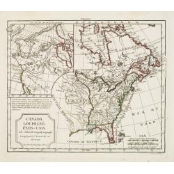
Canada, Louisiane, États-Unis. Par Robert de Vaugondy Géographé, Corrigés par le C.en Lamarche son Successeur. L'An 3.em de la République Franc?.
Two maps on one sheet. The map of the western part of North America is most notable for it's depiction of "Mer de L'Ouest" or "Sea of the West".A grea...
Date: Paris, 1795
Selling price: ????
Please login to see price!
Sold in 2016
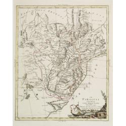
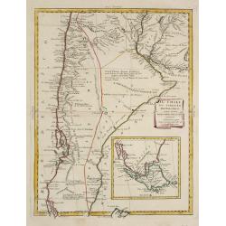
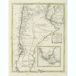
Il Paraguai Uraguai e Rio della Plata.
A finely engraved copper plate map that covers Paraguay, Uruguay and part of the contiguous countries. Good detail of the region around Buenos Ayres and the Rio de la Pla...
Date: Venise 1795
Selling price: ????
Please login to see price!
Sold
Iere / II Feuille de L' Amérique Méridionale
Louis Brion de la Tour (1756-1823), French geographer. ' Atlas Géneral, Civil et Ecclésiastique', 1766, ' Atlas Général', 1790-98.A map of South America on 2 sheets.
Date: Paris, c. 1795
Selling price: ????
Please login to see price!
Sold
Carte de la Baye du Bon Succès dans le Détroit de le Maire./ Carte de la partie S.E. de la Terre de Feu comprenant le Détroit de le Maire et une part.ie de la Terre des Etats. 1769.
Captain James Cook (1728-79), explorer, circumnavigator and hydrographer. Three voyages, 1768-71, 1772-75 and 1776-79. From 1778 on printed editions of ' Captain Cook's T...
Date: Paris, c. 1795
Selling price: ????
Please login to see price!
Sold in 2010
Carte de la Partie de l'Amerique Septentrionale, comprenant les Possessions Anglaises.
Louis Brion de la Tour (1756-1823), French geographer. ' Atlas Géneral, Civil et Ecclésiastique', 1766, ' Atlas Général', 1790-98. From Brunet's 'Histoire Universelle...
Date: Paris, c. 1795
Selling price: ????
Please login to see price!
Sold
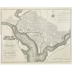
PLAN of the CITY of Washington, in the Territory of Columbia, ceded by the States of VIRGINIA AND MARYLAND to the United States of America, and by them established as the SEAT of their GOVERNMENT, after the YEAR 1800.
The famous 18th century plan of the Capital of Washington. This is the English issue of the official Thackara and Vallance plan, Philadelphia, 1792, which was made from L...
Date: London, 1795
Selling price: ????
Please login to see price!
Sold in 2009
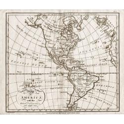
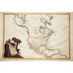
Map of America with the latest Discoveries 1795.
Map of America with the latest Discoveries 1795, by Samuel John Neele. Published May 10th 1795 by Cadell & Davies of the Strand London.Attractive small map of North a...
Date: London 1795
Selling price: ????
Please login to see price!
Sold in 2017

Homme Masque de l'Isle de Sandwich
From a French edition of Captain Cook's voyages.
Date: Paris, ca. 1795
Selling price: ????
Please login to see price!
Sold in 2020
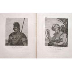
Pair of 2 prints: Winée, naturelle D'Owhyée; Tianna, Prince d'Atooi.
Two great portraits of native Hawaiians by John Meares. From Collection de Cartes Geographiques, Vues, Marines, Plans et Portraits, relatifs aux Voyages du Capitaine J. M...
Date: Paris, 1795
Selling price: ????
Please login to see price!
Sold in 2022
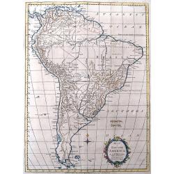
Map of South America.
Interesting map of South America. Features large blank areas inside Brazil and Argentina, but also a lot of details and place names along the coasts and rivers. Names als...
Date: London, 1795
Selling price: ????
Please login to see price!
Sold in 2016
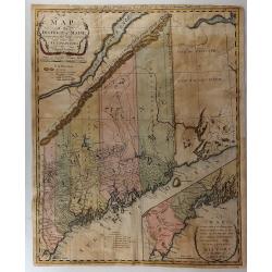
A Map of the District of Maine, Drawn from the Latest Surveys and Other Best Authorities.
A very lovely and important map. One of the first printed maps of Maine - At that time Maine was part of Massachusetts. The map was the frontispiece from James Sullivan�...
Date: Boston. 1795
Selling price: ????
Please login to see price!
Sold in 2017
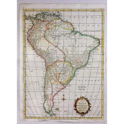
Map of South America.
A map of South America for the Rev. Dr. Robertson's “History of America” by Thos. Kitchin, 'Hydrographer to his Majesty'. It features a decorative floral title cartou...
Date: London, 1795
Selling price: ????
Please login to see price!
Sold in 2020
Map of the Gulf of Mexico, the Islands and Countries Adjacent.
A striking map of the West Indies, Gulf Coast, Florida, etc. Published in the Rev. Dr. Robertson's “History of America”. Includes a compass rose and decorative title ...
Date: London, 1795
Selling price: ????
Please login to see price!
Sold in 2018
Mexico or New Spain.
One of the most popular maps of Mexico and the Southwest of America during the late 18th century. The map reflects the contemporary commercial cartography of 1777, the da...
Date: London, 1795
Selling price: ????
Please login to see price!
Sold in 2018
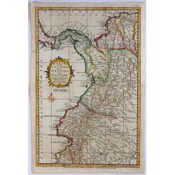
Map of the Countries of the South Sea from Panama to Guayquil.
A striking map of Central America, including Columbia, Ecuador, Panama, the New Kingdom of Granada and Quito. From Dr. Robertson's 'History of America'.Thomas Kitchin (17...
Date: London, 1795
Selling price: ????
Please login to see price!
Sold in 2018
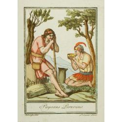
Paysans Peruviens.
Hand-colored mezzotints of Native Americans drawn by Labrousse and engraved by Laroque after Jacques Grasset de Saint-Sauveur.
Date: Paris,1796
Selling price: ????
Please login to see price!
Sold in 2010

Sauvage Iroquois.
Hand-colored mezzotints of Native Americans drawn by Labrousse and engraved by Laroque after Jacques Grasset de Saint-Sauveur.
Date: Paris,1796
Selling price: ????
Please login to see price!
Sold in 2011

Jongleur Iroquois.
Hand-colored mezzotints of Native Americans drawn by Labrousse and engraved by Laroque after Jacques Grasset de Saint-Sauveur.
Date: Paris,1796
Selling price: ????
Please login to see price!
Sold in 2011

Paysannes du Pérou.
Hand-colored mezzotints of Native Americans drawn by Labrousse and engraved by Laroque after Jacques Grasset de Saint-Sauveur.
Date: Paris,1796
Selling price: ????
Please login to see price!
Sold in 2010
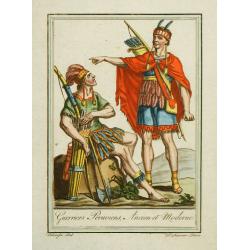
Guerriers Peruviens, Ancien et Moderne.
Hand-colored mezzotints of Native Americans drawn by Labrousse and engraved by Laroque after Jacques Grasset de Saint-Sauveur.
Date: Paris,1796
Selling price: ????
Please login to see price!
Sold in 2010
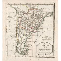
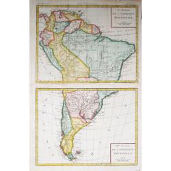
Paraguay, Chili, Terre Magellan.
Map of the southern part of South America.
Date: Paris, 1796
Selling price: ????
Please login to see price!
Sold in 2012
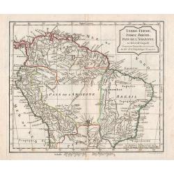
Terre-Ferme, Perou, Brésil, Pays de l\'Amazone.
Map of the northern part of South America.
Date: Paris, 1796
Selling price: ????
Please login to see price!
Sold in 2012
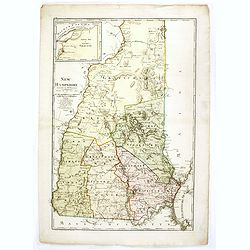
New Hampshire entworfen von D.F. Sotzmann. Hamburg bey Carl Ernst Bohn 1796 . . . No. II.
Extremely rare map of New Hampshire prepared by Daniel Friedrich Sotzmann for Christopher Ebeling's "Erdbeschreibung von Amerika", a project ended after only te...
Date: Hamburg, Carl Ernst Bohn, 1796
Selling price: ????
Please login to see price!
Sold in 2016
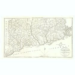
Rhode-Island and Connecticut.
Published in Boston by Thomas and Andrews before the end of the eighteenth century, for the Rev J. Morse in his "The American Universal Geography". The map was ...
Date: Boston, 1796
Selling price: ????
Please login to see price!
Sold in 2018
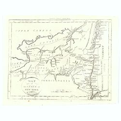
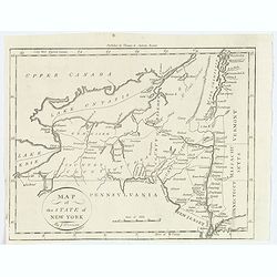
Map of the State of New York.
Published in Boston by Thomas and Andrews before the end of the eighteenth century, for the Rev J. Morse in his "The American Universal Geography". The map show...
Date: Boston, 1796
Selling price: ????
Please login to see price!
Sold in 2016
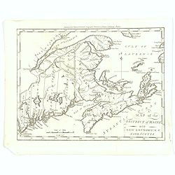
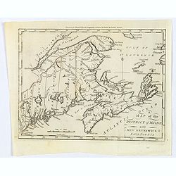
Map of the District of maine with New Brunswick & Nova Scotia.
Published in Boston by Thomas and Andrews before the end of the eighteenth century, for the Rev J. Morse in his "The American Universal Geography".A map showing...
Date: Boston, 1796
Selling price: ????
Please login to see price!
Sold in 2016
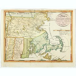
A map of Massachusetts from the best Authorities by J.Denison.
The map highlights Martha's Vineyard and Nantucket Island. The "Proposed Canal" is located near Sandwich. Beneath the oval title cartouche and distance scale is...
Date: Boston, 1796
Selling price: ????
Please login to see price!
Sold in 2021
Map of the State of New York.
A nice post revolutionary war map of the state of New York by James Denison, published in Boston by Thomas and Andrews. Map shows rivers, mountains, roads, state boundari...
Date: Boston, 1796
Selling price: ????
Please login to see price!
Sold in 2019
Map of the District of Maine with New Brunswick & Nova Scotia.
Published in Boston by Thomas and Andrews before the end of the eighteenth century, for the Rev J. Morse in his "The American Universal Geography".A map showing...
Date: Boston, 1796
Selling price: ????
Please login to see price!
Sold in 2019