Browse Listings in America
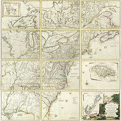
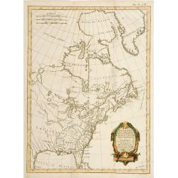
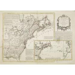
Le Colonie Unite dell America Settentr. le di Nouva Projezione . . .
A complete set of 12 maps that when joined together form a large map of North America. Shows North America west to the Mississippi and Spanish-owned Louisiana, and north ...
Date: Venise, 1778
Selling price: ????
Please login to see price!
Sold in 2019
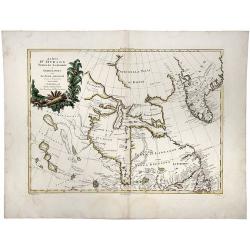
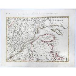
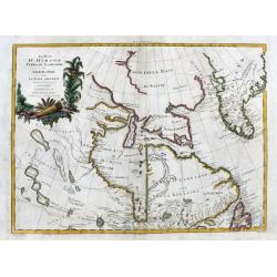
La Baja D' HUDSON Terra Di Labrador e Groenlandia con Le Isole Adiacenti.
An excellent, old outlined colored map of Hudson Bay, Baffin Bay, part of Greenland, Labrador and Northern Canada. With marvellous detail on the islands and coastlines, k...
Date: Venice, 1778
Selling price: ????
Please login to see price!
Sold in 2020
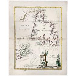
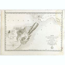
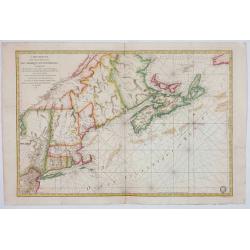
Le Isole di TERRA NUOVA e CAPO BRETON Di Nuova Projezione.
A gorgeous separate map of Newfoundland and Cape Breton Island, along with neighbouring Islands, including St. Pierre Michelon. An old outlined colored map with a cartouc...
Date: Venice, 1778
Selling price: ????
Please login to see price!
Sold in 2019
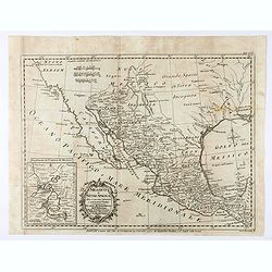
![[Map of the interior of North America and New Spain] (sheet: No.2)](/uploads/cache/82993-250x250.jpg)
[Map of the interior of North America and New Spain] (sheet: No.2)
An engraved, old colored map showing roads, wooded areas, swamps, and settlements; areas of Native American habitation and the route of the Spanish Galleons. Includes not...
Date: Vienna, 1778
Selling price: ????
Please login to see price!
Sold in 2019
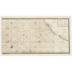
![[ Text page : Nautical directions to sail into the Harbour of New-York, & c.]](/uploads/cache/44836-250x250.jpg)
[ Text page : Nautical directions to sail into the Harbour of New-York, & c.]
Text page "Nautical directions to sail into the Harbour of New-York, & c.", taken from the "Atlantic Neptune". This superb sea chart constructed f...
Date: London, 1778
Selling price: ????
Please login to see price!
Sold in 2019
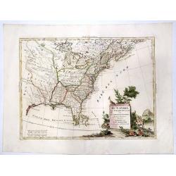
IL CANADA Le Colonie Inglesi Con La Luiglana e Florida. Di nuova Projezione.
A striking map of the United States and Canada, which includes references to the Upper and Lower English Colonies of Louisiana. One of the very few maps from the period w...
Date: Venice, 1778
Selling price: ????
Please login to see price!
Sold in 2020
![IL PAESE DE SELVAGGI OUTAGAMIANI, MASCOUTENSI, ILLINESI, E PARTE DELLE VI. NAZIONI. (Fogl. IV.)[Lake Michigan]](/uploads/cache/83526-250x250.jpg)
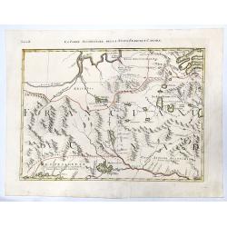
IL PAESE DE SELVAGGI OUTAGAMIANI, MASCOUTENSI, ILLINESI, E PARTE DELLE VI. NAZIONI. (Fogl. IV.)[Lake Michigan]
A striking and important regional map, bounded by the Missouri River, Lake Michigan and what would ultimately become Michigan in the north and extending south to include ...
Date: Venice, 1778
Selling price: ????
Please login to see price!
Sold in 2020
LA PARTE OCCIDENTALE DELLA NUOVA FRANCIA O CANADA (Fogl. II.)
A striking and detailed map of the region bounded by the Ottawa River and Hudson Bay, drawn from John Mitchell's seminal map. It shows Messesaguesi (Massachusetts) in sou...
Date: Venice, 1778
Selling price: ????
Please login to see price!
Sold in 2020
![IL PAESE DE SELVAGGI OUTAUACESI E KILISTINESI INTORNO AL LAGO SUPERIORE. (Fogl. I.)[LAKE SUPERIOR,FLORIDA&BAHAMAS]](/uploads/cache/83528-250x250.jpg)
IL PAESE DE SELVAGGI OUTAUACESI E KILISTINESI INTORNO AL LAGO SUPERIORE. (Fogl. I.)[LAKE SUPERIOR,FLORIDA&BAHAMAS]
A striking and detailed map of the region the Great Lakes and an inset showing Florida and Bahamas. This map is a part of the Italian edition of John Mitchell's map of th...
Date: Venice, 1778
Selling price: ????
Please login to see price!
Sold in 2020
PARTE ORIENTALE DEL CANADA, NUOVA SCOZIA SETTENTRIONALE, E PARTE DI LABRADOR. (Fogl. III.)
A striking and detailed, important regional map, dissected diagonally by the St Lawrence and showing a portion of Southeastern Canada. This map is a part of the Italian e...
Date: Venice, 1778
Selling price: ????
Please login to see price!
Sold in 2020
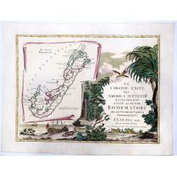
LE COLONIE UNITE dell' AMERICA SETTENTRle di nuova projezione assee li signori. . . (Title Page and Bermuda)
A striking, beautifull, title page of Zatta's twelve sheet monumental work, with inset showing the island of Bermuda. This map is a part of the Italian edition of John Mi...
Date: Venice, 1778
Selling price: ????
Please login to see price!
Sold in 2020
![LA PENSILVANIA, LA NUOVA YORK, IL JERSEY SETTENTRIO:le, CON LA PARTE OCCIDENTALE DEL CONNECTICUT. . . (Fogl. V.)[Lakes Huron, Erie, and Ontario]](/uploads/cache/83531-250x250.jpg)
LA PENSILVANIA, LA NUOVA YORK, IL JERSEY SETTENTRIO:le, CON LA PARTE OCCIDENTALE DEL CONNECTICUT. . . (Fogl. V.)[Lakes Huron, Erie, and Ontario]
A striking map of the north eastern section of the Italian edition of Mitchell's seminal map of North America, bounded by Lakes Huron & Oswego and Ohio in the west an...
Date: Venice, 1778
Selling price: ????
Please login to see price!
Sold in 2020
Carte du Théatre de la Guerre Entre les Anglais et les Américains: Dressée d'apres les Cartes Anglaises les plus modernes
Uncommon 1778 edition with the site of Burgoyne's surrender at Saratoga (here spelled "Saharatoga").This is an important separately published French map of the ...
Date: Paris, Esnauts et Rapilly, 1778
Selling price: ????
Please login to see price!
Sold in 2021
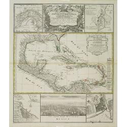
Messico o Nuova Spagna . . .
Map of Mexico Robertson’s "Storia d'America", printed in 1777. After a map of Thomas Kitchin.
Date: Florence, Gatti, 1778
Selling price: ????
Please login to see price!
Sold in 2021
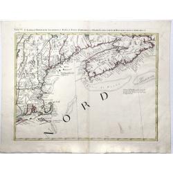
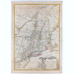
Fogl. VI. L' Acadia Le Provincie di Sagadahook e Main La Nuova Hampshire La Rhode Island e Parte Di Massachusset e Connecticut.
The 6th sheet from an important twelve-sheet map, of the south east Canada and north east United States of America. The 12 map Antonio Zatta's version of John Mitchell'...
Date: Venice, 1778
Selling price: ????
Please login to see price!
Sold in 2020
La Baja d' Hudson terra di Labrador e Groenlandia....
Great map of parts of Canada with Hudson Bay, Baffin Bay, Labrador, and Greenland. With many details such as Forts, settlements, bays, islands, indian regions, and unfini...
Date: Venice, 1778
Selling price: ????
Please login to see price!
Sold in 2020
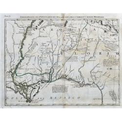
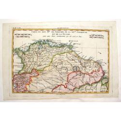
Luigiana Inglese, colla Parte Occidentale della Florida, della Giorgia, e Carolina Meridonale.
A very interesting Italian map based on John Mitchell's important map from 1755. It shows the Gulf Coast from Florida until the Mississippi Delta. It includes Biloxi, Pen...
Date: Venice, 1778
Selling price: ????
Please login to see price!
Sold in 2020
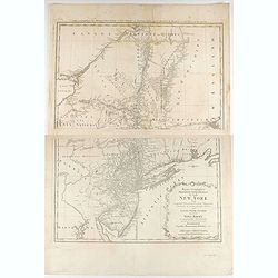
Mappa geographica Provinciæ Nova Eboraci ab Anglis New-York dictæ ex ampliori delineatione ad exactas dimensiones concinnata in arctius spatium redacta cura Claudii Josephi Sauthier ...
Mappa geographica Provinciæ Nova Eboraci ab Anglis New-York dictæ ex ampliori delineatione ad exactas dimensiones concinnata in arctius spatium redacta cura Claudii Jos...
Date: Nuremburg, 1778
Selling price: ????
Please login to see price!
Sold in 2020

Marché Désclaves Pl.XI. / Coton / Ventilateur et Mache.
Plates from the small edition of Diderot's Encyclopaedia. Engraved by Laurent. Very important work as it is giving an inventory of the science and craftsmanship of the 18...
Date: Paris 1779
Selling price: ????
Please login to see price!
Sold
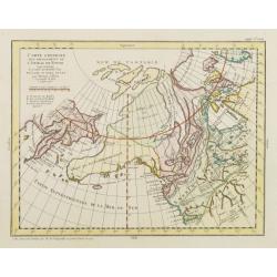
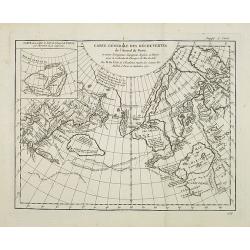
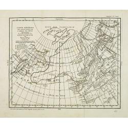
Carte Générale des Découvertes de l'Amiral de Fonte representant la grande probabilité d'un Passage au Nord Ouest. . .
Robert de Vaugondy based this map of the northern Pacific and Alaska on a publication by Thomas Jefferys in London in 1768. Published in the supplement to Diderot’s &qu...
Date: Paris, 1779
Selling price: ????
Please login to see price!
Sold in 2013
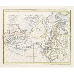
Carte générale des découvertes de l'Admiral de Fonte ..
Based on the map of the northern Pacific, published by Jacques-Nicolas de l'Isle in Paris in 1752. Shows clearly the extraordinary network of channels supposed to link th...
Date: Paris 1779
Selling price: ????
Please login to see price!
Sold
Carte générale des découvertes de l'Admiral de Fonte ..
Based on the map of the northern Pacific, published by Jacques-Nicolas de l'Isle in Paris in 1752. Shows clearly the extraordinary network of channels supposed to link th...
Date: Paris 1779
Selling price: ????
Please login to see price!
Sold
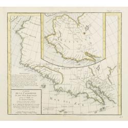
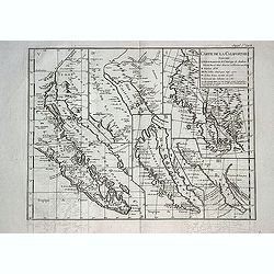
Carte de la Californie et des Pays Nord-Ouest..4de Carte
Diderot's famous 2 on 1 map showing the two early mappings of the west coast of North America, the first after Visscher, the second after Plancius' World map. Both show t...
Date: Paris, 1779
Selling price: ????
Please login to see price!
Sold in 2013
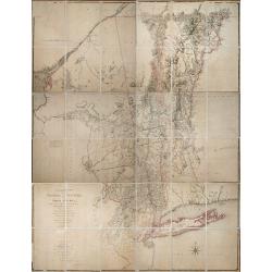
A Chorographical Map of the Province of New-York in North America, Divided into Counties, Manors, Patents and Townships ... January 1st. 1779.
CLAUDE JOSEPH SAUTHIER’S SUPERB MAP OF THE PROVINCE OF NEW YORK IS A TOUR-DE-FORCE. Sauthier (1736-1802) was an engineer who accompanied Governor William Tryon to North...
Date: London, January 1st. 1779
Selling price: ????
Please login to see price!
Sold in 2013
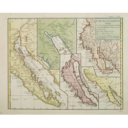
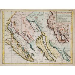
Carte de la Californie suivant..
Five maps on one folding sheet, showing the development of the mapping of California. The map is from Diderot's "Encyclopedie" which contains ten maps o...
Date: Paris, 1779
Selling price: ????
Please login to see price!
Sold in 2009
![Carte Des Nouvelles Decouvertes dresseee par Phil. Buache... [with] Extrait d'une Carte Japonoise de l'Univers apportee en Europe par Kaempfer . . . [Bay of the West]](/uploads/cache/25609-250x250.jpg)
Carte Des Nouvelles Decouvertes dresseee par Phil. Buache... [with] Extrait d'une Carte Japonoise de l'Univers apportee en Europe par Kaempfer . . . [Bay of the West]
This map is most notable for it's depiction of "Mer de L'Ouest" or "Sea of the West", a great sea, easily the size of the Mediterranean, to flow from ...
Date: Paris, 1779
Selling price: ????
Please login to see price!
Sold in 2014
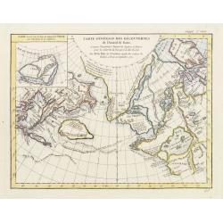
Carte Générale des Découvertes de l'Amiral de Fonte, et autres . . .
A map from Diderot's Encyclopédie which makes the case for a northwest passage. Included as part of the evidence is the route of Admiral De Fonte, a completely fictitiou...
Date: Paris, (1752) 1779
Selling price: ????
Please login to see price!
Sold in 2011
Carte générale des découvertes de l''Amiral de Fonte. . .
Based on the map of the northern Pacific, published by Jacques-Nicolas de l''Isle in Paris in 1752. It shows clearly the extraordinary network of channels supposed to lin...
Date: Paris, 1779
Selling price: ????
Please login to see price!
Sold in 2014
Carte de la Californie et des Pays Nord-Ouest ?
The map is from Diderot's Encyclopedie which contains ten maps of America, Asia and the Arctic Regions. This 2 on 1 map shows the two early mappings of the west coast of ...
Date: Paris, 1779
Selling price: ????
Please login to see price!
Sold in 2010
Carte de la Californie suivant . . .
Five maps on one folding sheet, showing the development of the mapping of California. The map is from Diderot's "Encyclopedie" which contains ten maps of Americ...
Date: Paris, 1779
Selling price: ????
Please login to see price!
Sold in 2009
Carte des Nouvelles découvertes ?
The map is from Diderot's 'Encyclopedia' which contains ten maps of Asia, America and the Arctic Regions. In both maps there are texts ago. by Kaempfer who refers to voya...
Date: Paris, 1779
Selling price: ????
Please login to see price!
Sold in 2009
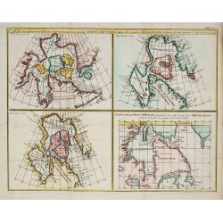
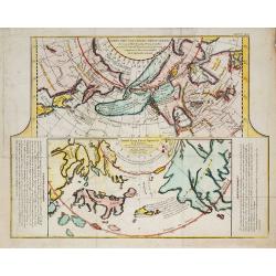
Carte qui représnte ? Terres Arctiques ... Suppl.Carte 9.
From Diderot's Encyclopaedia. Four maps on one sheet showing Hudson Bay according to Sanson's map of 1750 and De L'Isle 1700 and 1703. One map showing track of Henri Elli...
Date: Paris, 1779
Selling price: ????
Please login to see price!
Sold in 2010
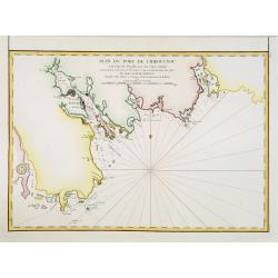
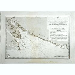
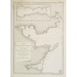
Plan du port de Chibouctou à la cote de l'Acadie avec les cotes voisines. . .
Chart of the vicinity of Halifax Harbor from Chebucto Head to the head of Bedford Basin.Issued in Neptune americo-septentrionale by "Depot Général de la Marine&quo...
Date: Paris, 1779
Selling price: ????
Please login to see price!
Sold in 2013
Carte de la Californie et des Pays Nord-Ouest. . .
Diderot's famous 2 on 1 map showing the two early mappings of the west coast of North America, the first after Visscher, the second after Plancius' World map. Both show t...
Date: Paris, 1779
Selling price: ????
Please login to see price!
Sold in 2019
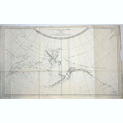
Carte de la côte N. O. de l\'Amérique et de la côte N. E. de l\'Asie reconnues en 1778 et 1779..
Map of the north Pacific with Alaska, engraved by Bernard.
Date: Paris, c. 1779
Selling price: ????
Please login to see price!
Sold in 2013
Carte de la Californie suivant. . . (Five maps on one sheet)
Five maps on one folding sheet, showing the development of the mapping of California. The map is from Diderot's Encyclopedie which contains ten maps of America, Asia and ...
Date: Paris, 1779
Selling price: ????
Please login to see price!
Sold in 2013
Carte de L\'Isle de la Martinique.
Fine copper engraved map of the Island of Martinique in the Caribbean. It is detailed with lakes, rivers, cities, towns, mountains and forests. Nice block-style cartouche...
Date: Paris, 1779
Selling price: ????
Please login to see price!
Sold in 2014
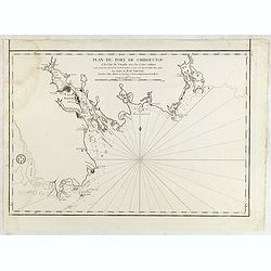
Plan du port de Chibouctou à la cote de l'Acadie avec les cotes voisines. . .
French chart of the vicinity of Halifax Harbor from Chebucto Head to the head of Bedford Basin.Issued in Neptune americo-septentrionale by "Depot Général de la Mar...
Date: Paris, 1779
Selling price: ????
Please login to see price!
Sold in 2015
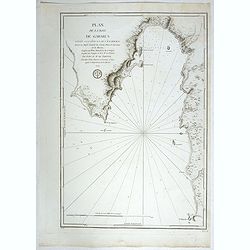
Plan du Bassin et de la Riviere du Port Royal ou Annapolis, dans l'Acadie sur la Cote Orientale de la Baie Francois . . .
French chartof the Bay of Annapolis Royal, a small Canadian town located in the western part of Annapolis County, Nova Scotia, and was known as Port Royal until the Conqu...
Date: Paris, 1779
Selling price: ????
Please login to see price!
Sold in 2018
Plan de l'isthme de l'Acadie comprenant le Beau-Bassin avec une partie de la Baie Verte...
French chart of the Isthmus of Chignecto, an isthmus bordering the Maritime provinces of New Brunswick and Nova Scotia, Canada. Made under the direction of M. de Sartine....
Date: Paris, ca.1779
Selling price: ????
Please login to see price!
Sold in 2017
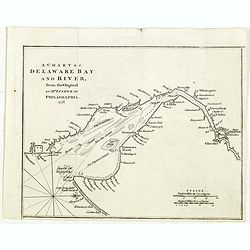
A chart of Delaware Bay and River : from the original by Mr. Fisher of Philadelphia 1776
Taken from the important chart of Delaware Bay and River up to Philadelphia by Joshua Fisher in 1776. Kashnor notes, "Shows the river from Cape James to Philadelphia...
Date: London, July 1779
Selling price: ????
Please login to see price!
Sold in 2021
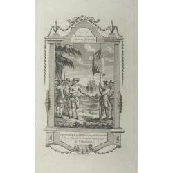
Sir Walter Raleigh ordering the standard of Queen Elizabeth to be erected on the coast of Virginia.
A very decorative historical scene of Sir Walter Raleigh ordering the standard of Queen Elizabeth to be erected on the coast of Virginia in 1584, engraved by Taylor for '...
Date: London, 1779
Selling price: ????
Please login to see price!
Sold in 2015
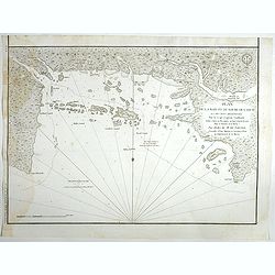
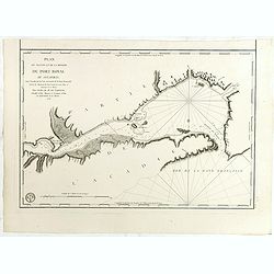
Plan de la Baie et du Havre de Casco et des Iles Adjacents. . .
Sea chart of Casco Bay in Maine. Published in "Neptune Americo-Septentrional" at the time of the American Revolution. According to the title prepared by Antoine...
Date: Paris, ca.1779
Selling price: ????
Please login to see price!
Sold in 2018
Plan du Port Dauphin, de la rade de St.Anne, de l'entrée de Labrador et de la Baie de Niganiche. . .
Sea chart of the rade of St.Anne. Published in "Neptune Americo-Septentrional" at the time of the American Revolution. According to the title prepared by Antoin...
Date: Paris, ca.1779
Selling price: ????
Please login to see price!
Sold in 2018
Plan de la baie de Gabarus située a la côte S.E. de l'Île Royale. . .
Sea chart of Gabarus Bay. Published in "Neptune Americo-Septentrional" at the time of the American Revolution. According to the title prepared by Antoine Sartin...
Date: Paris, ca.1779
Selling price: ????
Please login to see price!
Sold in 2018
![Plan du Port De La Riviere St. Jean Situe a la Cote Septentrionale De La Baie Francoise de L'Acadie. . . [with] Plan du port e la Heve . . . and Plan du port Rochelois. . .](/uploads/cache/39162-250x250.jpg)
Plan du Port De La Riviere St. Jean Situe a la Cote Septentrionale De La Baie Francoise de L'Acadie. . . [with] Plan du port e la Heve . . . and Plan du port Rochelois. . .
Early chart of the Saint John River and St. John together with "Plan du port e la Heve . . ." and "Plan du port Rochelois. . ." Published in "Nep...
Date: Paris, ca.1779
Selling price: ????
Please login to see price!
Sold in 2018
![Plan du Port De La Riviere St. Jean Situe a la Cote Septentrionale De La Baie Francoise de L'Acadie. . . [with] Plan du port e la Heve . . . and Plan du port Rochelois. . .](/uploads/cache/39163-250x250.jpg)
Plan du Port De La Riviere St. Jean Situe a la Cote Septentrionale De La Baie Francoise de L'Acadie. . . [with] Plan du port e la Heve . . . and Plan du port Rochelois. . .
Early chart of the Saint John River and St. John together with "Plan du port e la Heve . . ." and "Plan du port Rochelois. . ." Published in "Nep...
Date: Paris, ca.1779
Selling price: ????
Please login to see price!
Sold in 2018
![Plan de la baie de Nérichac, à la côte du sud de l'Île Madame. . . [with] Plan du port Toulouse, à la cote du sud de l'isle Royale. . .](/uploads/cache/39164-250x250.jpg)
Plan de la baie de Nérichac, à la côte du sud de l'Île Madame. . . [with] Plan du port Toulouse, à la cote du sud de l'isle Royale. . .
Early charts of Nerichac Bay on the south coast of Isle Madame together with chart of Port Toulouse on the south coast of Isle Royale. Published in "Neptune Americo-...
Date: Paris, ca.1779
Selling price: ????
Please login to see price!
Sold in 2018
![[Untitled chart of Portland and Falmouth in Maine]](/uploads/cache/39181-250x250.jpg)
[Untitled chart of Portland and Falmouth in Maine]
Fine chart of Portland and Falmouth in Maine, showing the homesteads, roads, and topography in the vicinity of Portland to the lower left corner. Taken from the "Atl...
Date: London, 1779
Selling price: ????
Please login to see price!
Sold in 2017
![[Untitled chart of Coast of Maine showing Blue Hill Bay, Penobscot Bay, Belfast Bay, Islesboro Island, Deer Island, and other islands]](/uploads/cache/39182-250x250.jpg)
[Untitled chart of Coast of Maine showing Blue Hill Bay, Penobscot Bay, Belfast Bay, Islesboro Island, Deer Island, and other islands]
Fine chart of coast of Maine showing Blue Hill Bay, Penobscot Bay, Belfast Bay, Islesboro Island, Deer Island, and other islands Taken from the "Atlantic Neptune&quo...
Date: London, 1779
Selling price: ????
Please login to see price!
Sold in 2017
Carte Reduite de L'Acadie ou Nouvelle Ecosse. Comprenant une partie de l'ile Royale de l'ile St. Jean et du Canada.
A map of Acadia or Nova Scotia comprising part of Cape Breton, St. John Island and Canada written at the General Depot of Maps, Plans and Marine Journals by order of Mr. ...
Date: Paris, 1779
Selling price: ????
Please login to see price!
Sold in 2020
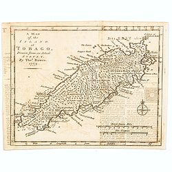
A Map of the Island of Tobago, drawn from an Actual Survey.
An nice, small map delightfully engraved with good detail. The island is sectioned off into seven distinct divisions, each identifying the number of acres and estates. Ne...
Date: London, 1779
Selling price: ????
Please login to see price!
Sold in 2020
![Carte Des Nouvelles Decouvertes dresseee par Phil. Buache... [with] Extrait d'une Carte Japonoise de l'Univers apportee en Europe par Kaempfer . . . [Bay of the West]](/uploads/cache/46319-250x250.jpg)
Carte Des Nouvelles Decouvertes dresseee par Phil. Buache... [with] Extrait d'une Carte Japonoise de l'Univers apportee en Europe par Kaempfer . . . [Bay of the West]
A very interesting pair of rare maps published as a single sheet in the 10 part series of maps created by Robert de Vaugondy in his 'supplement Receuil de 10 cartes trait...
Date: Paris, 1779
Selling price: ????
Please login to see price!
Sold in 2020
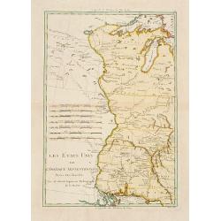
Les États Unis de L'Amerique Septentrionale..
Attractive map covering the Mississippi River and the Great Lakes and Texas region, prepared by R.Bonne and included in his "Atlas Ecyclopédique.."Ri...
Date: Paris 1780
Selling price: ????
Please login to see price!
Sold
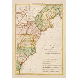
Les États Unis de L''Amerique Septentrionale..
Attractive map covering North Americas east coast. Prepared by R.Bonne and included in his "Atlas Ecyclopédique.."Rigobert Bonne (1727-1795) was engi...
Date: Paris 1780
Selling price: ????
Please login to see price!
Sold
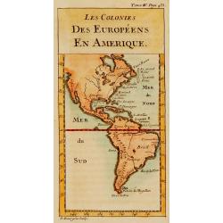
Les colonies des Européens en Amérique.
Map of the American continent showing the European settlements.
Date: Paris, c.1780
Selling price: ????
Please login to see price!
Sold
Carte Réduite Des Côtes Orientales De L' Amérique Septentrionale Contenant Celles des provinces de New-York et de la Nouvelle Angleterre..
A well engraved and highly detailed chart that was issued in Neptune americo-septentrionale. Showing the East Coast from Chaleur Bay to New Jersey, encompassing all of Ne...
Date: Paris, 1780
Selling price: ????
Please login to see price!
Sold in 2020
Partie du Nord de L'Amerique Septentrionale..
Rigobert Bonne (1727-1795), a prolific French cartographer, flourished between about 1760 and 1778, working in the French Hydrographical Office, and appointed as Hydrogra...
Date: Paris 1780
Selling price: ????
Please login to see price!
Sold
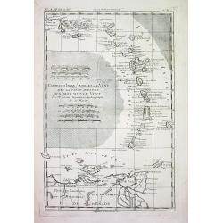
CARTE DES ISLES ANTILLES ou du VENT AVEC LA PARTIE ORIENTALE DES ISLES SOUS LE VENT
Beautiful and detailed copper-engraved map the lesser Antilles, from Puerto Rico to the coast of Venezuela. The map bears seven distance scales. From "Atlas de toute...
Date: Paris, c1780
Selling price: ????
Please login to see price!
Sold
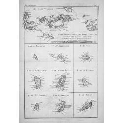
SUPPLÉMENT POUR LES ISLES ANTILLES, EXTRAIT DES CARTES ANGLOISES...
Beautiful and detailed copper-engraved map with excellent detail on the Virgin Islands + 9 inset maps of: Barbuda, St. Kitts, Antigua, Dominica, St. Lucia, Barbados, St. ...
Date: Paris, c1780
Selling price: ????
Please login to see price!
Sold
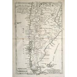
Mappa Paraquariae in multis a me correcta. . .
A rare map of Paraguay from Dobrizhoffer Martin (1717-1791) Historia de Avipones y Mocobies. Engraved by F.Assner.The map includes all of Argentina from 11º to 370º sou...
Date: Vienna, 1780
Selling price: ????
Please login to see price!
Sold in 2011
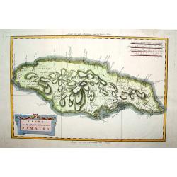
Kaart van het Eiland Jamaika.
An uncommon and very attractive map of Jamaica. The island's mountains are boldly engraved and excellent detail of the various river systems is provided. The parishes are...
Date: Amsterdam, c. 1780
Selling price: ????
Please login to see price!
Sold
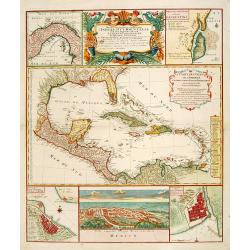
Mappa Geographica..Indiae Occidentalis..
Six varying sized insets depict the West Indies: Panama, Saint Augustine, Vera Cruz, Santo Domingo, and, a birds-eye view of Mexico City. The primary, largest inset map h...
Date: Nuremberg, 1780
Selling price: ????
Please login to see price!
Sold
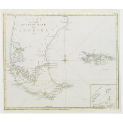
Kaart van het Zuidlyk Eind van Amerika. 1775.
Uncommon chart of the tip of South America, showing Patagonia, Tierra del Fuego and the Falkland Islands. With an inset of Staaten Land in the lower right corner.Publishe...
Date: Amsterdam c. 1780
Selling price: ????
Please login to see price!
Sold
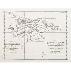
Carte de Maidenland ou de la Virginie de Hawkins.. Et du Canal Falkland..
Fine chart of the Falkland Islands called Maidenland or Virginie by Sir Richard Hawkins who discovered the islands in 1574.Also shows the Canal Falkland, the Strait betwe...
Date: Paris 1780
Selling price: ????
Please login to see price!
Sold
Karte von der Süd-See oder dem Stillen Meere..
The right hand sheet of a 2-sheet map of the Pacific. Depicting Mexico and California, most northern name is Punta de los Reyes, most southern is Acapulco, including Bay ...
Date: Paris, 1780
Selling price: ????
Please login to see price!
Sold in 2016
Mappa Geographica.. Indiae Occidentalis..
Six varying sized insets depict the West Indies: Panama, Saint Augustine, Vera Cruz, Santo Domingo, and a birds-eye view of Mexico City. The primary, largest inset map ha...
Date: Nuremberg, 1780
Selling price: ????
Please login to see price!
Sold in 2012
Carte du Nouvelle Royaume de Grenade, de Andalousie et de la Guyane.
Copper engraved for "Atlas de Toutes les Parties Connues du Globe Terrestre". From Panama to the mouth of the Amazon. BONNE, RIGOBERT (1729-1795). Bonne was �...
Date: Paris, 1780
Selling price: ????
Please login to see price!
Sold in 2013
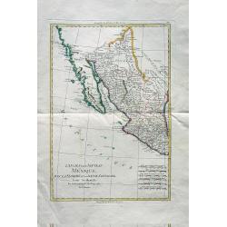
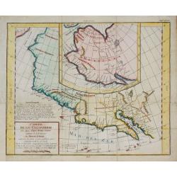
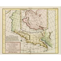
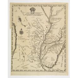
L'Ancien et le Nouveau Mexique avec la Floride et la Basse Louisiane. Partie Occidentale.
Excellent early map of California, Texas, Arizona, New Mexico, and Mexico. Very detailed with many towns, jesuit missions, forts, Indian areas, etc. Early geography of in...
Date: Paris, c 1780
Selling price: ????
Please login to see price!
Sold in 2010
Carte Nouvelle des Posséssions Angloises en Amérique. . .
Third state, of this rare and attractive map shows Eastern Canada and the American colonies. It is important as it gives a clear notion of the international intrigues and...
Date: Paris, Moithey et Crepy, 1780
Selling price: ????
Please login to see price!
Sold in 2018
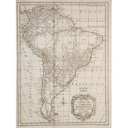
Carte de l'Amérique Méridionale, pour l'Histoire Générale des Voyages in 8º.
A nice map of South-America.
Date: Paris, 1780
Selling price: ????
Please login to see price!
Sold in 2010
Carte de la baie des chaleurs a la côte occidentale du golfe de St Laurent. . . / Plan du havre de Ristigouche.
A well engraved and highly detailed two-in-one chart of "la baie des chaleurs" in Canada along the St. Laurence.Prepared in 1724 by L'Hermite and edited by the ...
Date: Paris, 1780
Selling price: ????
Please login to see price!
Sold in 2010
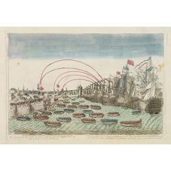
Vue de la prise des forts et ville de havane par les Anglois en 1762.
So-called optical print illustrating a perspective view of the siege of Havana by the English troops in 1762.Mondhare, active at rue St.Jacques a l'Hotel Saumur, was a we...
Date: Paris, c.1780
Selling price: ????
Please login to see price!
Sold in 2016
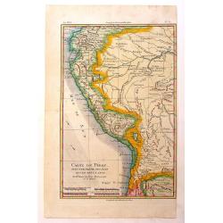
Carte du Perou avec Une Partie des Pays Qui en Sont a L'Est
An interesting map of Peru with the "Country of Amazon" on it Eastern border. From "Atlas de Toutes les Parties Connues du Globe Terrestre". Detailed ...
Date: Paris, 1780
Selling price: ????
Please login to see price!
Sold in 2014
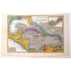
Les Isles Antilles et le Golfe du Mexique.
A beautiful colored map of the Gulf of Mexico with an inset map of Bermuda Island. From "Atlas de Toutes les Parties Connues du Globe Terrestre". Detailed with ...
Date: Paris - 1780
Selling price: ????
Please login to see price!
Sold in 2013
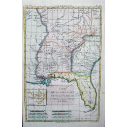
Carte de la Louisiane et de la Floride
Interesting map of the Southeast and the Mississippi River Valley. The map extends from Charleston, South Carolina west to include New Orleans and north well into Illinoi...
Date: Paris, c1780
Selling price: ????
Please login to see price!
Sold in 2013
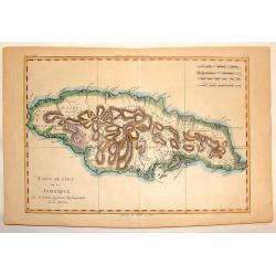
Carte de L'Isle de la Jamaique.
Hand-colored, copper plate map of the island of Jamaica in the Caribbean. Detailed presentation of the settlements, ports and forts. BONNE, RIGOBERT (1729-1795). Bonne w...
Date: Paris, 1780
Selling price: ????
Please login to see price!
Sold in 2013
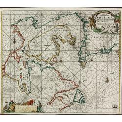
Pascaarte vande Noorder Zee Custen van America, vande West-Hoeck van Ysland doorde Straet Davis en Hudson, tot aen Terra Neuf
Fourth and last edition of van Keulen's chart of the Arctic Canada with the Hudson Bay and the supposed Northwest Passage. First published in 1680. The map is based upon ...
Date: Amsterdam, 1780
Selling price: ????
Please login to see price!
Sold in 2013
![L\'Amerique divisee en ses principaux Etats . . . [Sea of the West]](/uploads/cache/34033-250x250.jpg)
L\'Amerique divisee en ses principaux Etats . . . [Sea of the West]
America showing massive Seam of the West, Mississippi & tributaries, Colonies, excellent detail in southwest along Rio Grande, and strangely misspelled L.Winnepeg wit...
Date: Venise, 1780
Selling price: ????
Please login to see price!
Sold in 2013
Carte du Chili depuis le Sud du Perou Ju Squ\'au Cap horn avec partie des Regions qui en sont a L\'Est. Par M. Bonne, Ingr. Hydrographe de la Marine.
The decorative map is showing Chili, Patagonia, the Magellan Street and the Falkland Islands.
Date: Paris 1780
Selling price: ????
Please login to see price!
Sold in 2013