Browse Listings in America
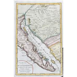
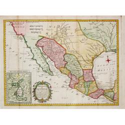
Carte De La Californie...
Map of Baja California, parts of Mexico, and Arizona. Very detailed with settlements, mountains, islands, missions, Indian tribes (Apache, Pericu, Yuma and Cochimi). Thi...
Date: Amsterdam, 1777
Selling price: ????
Please login to see price!
Sold in 2020
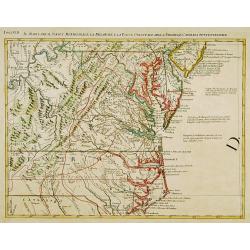
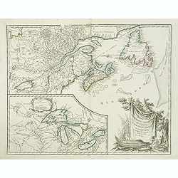
![Carte nouvelle de l'Amérique angloise contenant tout ce que les Anglois possèdent […] avec la Floride / gravée[…] par Maththias Albert Lotter. . .](/uploads/cache/47847-250x250.jpg)
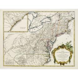
Carte nouvelle de l'Amérique angloise contenant tout ce que les Anglois possèdent […] avec la Floride / gravée[…] par Maththias Albert Lotter. . .
A large, beautiful and detailed map of the Eastern Seaboard, from Northern Florida St. Augustine) to Newfoundland, and the St. Lawrence Gulf, including numerous Indian tr...
Date: Augsburg, 1777
Selling price: ????
Please login to see price!
Sold in 2023
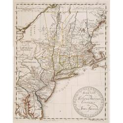
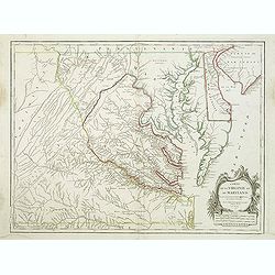
Il Maryland, il Jersey Meridionale la Delaware e la..
Attractive map covering Baltimore, Washington DC, North Carolina. In the north Philadelphia and in the south to New Bern. From Zatta's Atlante Novissimo.
Date: Venice 1778
Selling price: ????
Please login to see price!
Sold
Special Karte von den Mittleren Brittischen Colonien..
Uncommon German map of the east coast of North America. Engraved by T.A.Pingeling. From Bescheibung des brittischen Amerika by Christian Leiste.
Date: Wolfenbüttel 1778
Selling price: ????
Please login to see price!
Sold
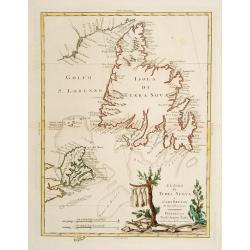
Le Isole di Terra Nuova e Capo Breton .
Newfoundland and Cape Breton. The title vignette shows fish being dried, an indication of the importance of the fishing industry there. Published in Zatta's "Atlante...
Date: Venice 1778
Selling price: ????
Please login to see price!
Sold
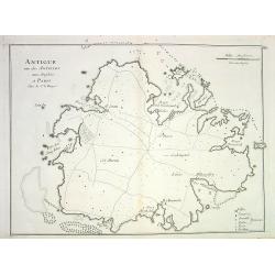
Antigue une des Antilles aux Anglois...
Detailed copper-engraved chart of Antigua, showing ports, anchor spots, reefs, roads, forts and towns. With key and distance scale.
Date: Paris, 1778
Selling price: ????
Please login to see price!
Sold in 2008
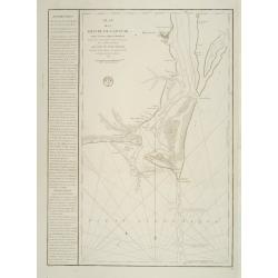
Plan de la Riviere du Cap Fear depuis la Barre jusques a Brunswick?. (Cape Fear)
A well engraved and highly detailed chart that was issued in Neptune Americo-Septentrionale. This chart is based on Sayer & Bennett's chart that was issued in 1776 an...
Date: Paris 1778
Selling price: ????
Please login to see price!
Sold
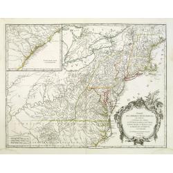
Carte des troubles De L'Amerique..New-York.. Jersey..
A French edition of this uncommon map giving good detail of the states of New York and New Jersey. Claude Joseph Sauthier was a German surveyor from Strasbourg who immigr...
Date: Paris 1778
Selling price: ????
Please login to see price!
Sold
Carte de la Baie de Chesapeake et de la Partie navigable des Rivieres, James, York, Patowmack, Patuxen, Patapsco, North-East, Choptank et Pokomack... par ordre de M. de Sartine.
A French version of Anthony Smith's important and detailed chart of the Chesapeake and surrounding waterways. The first edition was entitled "A New and Accurate Char...
Date: Paris 1778
Selling price: ????
Please login to see price!
Sold
Partie de l'Amerique septentrionale.. le cours de L'Ohio..
From the Atlas Universel , a detailed map extending the length of the east coast from Penobscot Bay to Cape Fear and, in an inset, from Cape Fear to Fort St.Georges.This ...
Date: Paris (1755) 1778
Selling price: ????
Please login to see price!
Sold
Mexico of Nieuw Spanje.
A map of Mexico and Texas ( called Tecas) from the Dutch edition of Robertson's ' History of America'.
Date: Amsterdam, 1778
Selling price: ????
Please login to see price!
Sold in 2018
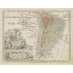
America Meridionalis per sua regna provinc: et Ins. . .
Miniature map of South America, showing the continent too narrowly and the Salomon Islands too near to South America. The coastline is surrounded with place names. Routes...
Date: Augsburg, J.M.Will, 1778
Selling price: ????
Please login to see price!
Sold in 2012

Carte de la Dominique prise par les François Le 7 septembre 1778. . .
A rare, one of the finest maps of Dominica ever produced, with insets of Charlottesville with its attack by the French on 7 September 1778. Also small inset map of the Ca...
Date: Paris, 1778
Selling price: ????
Please login to see price!
Sold
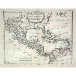
Nouvelle Espagne, Nouveau Mexique, Isles Antilles
Map of the 18th century Spanish territories of New Spain and New Mexico together with islands of the Caribbean. Accurate coastlines and good delineation of the rivers alo...
Date: Paris, 1778
Selling price: ????
Please login to see price!
Sold in 2009
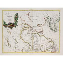
La Baja D'Hudson Terra di Labrador e Groenlandia.
Decorative map of Nova Scotia, Hudson Bay and part of Greenland. With many names of villages, as well engraved mountains and rivers are shown.Published in Zatta's "A...
Date: Venice, 1778
Selling price: ????
Please login to see price!
Sold in 2009
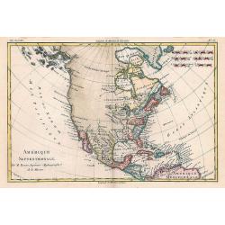
Amérique Septentrionale.
Interesting copper-engraved map of North America with Central America, the Caribbean, and parts of South America. Shows large unexplored blank parts in nowadays Western ...
Date: Paris, c1778
Selling price: ????
Please login to see price!
Sold in 2010
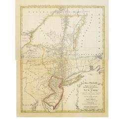
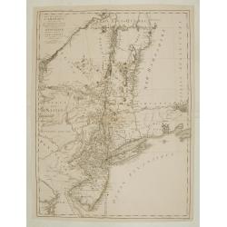
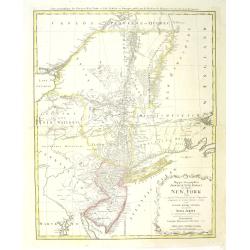
Mappa geographica Provinciæ Nova Eboraci ab Anglis New-York dictæ ex ampliori delineatione ad exactas dimensiones concinnata in arctius spatium redacta cura Claudii Josephi Sauthier cui accedit Nova Jersey ex topographicis observationibus.
Homann Heirs' edition of Sauthier's celebrated map of New York and New Jersey, made during the Revolutionary War. Also shows portions of Pennsylvania and New England. Rel...
Date: Nuremburg, 1778
Selling price: ????
Please login to see price!
Sold in 2018
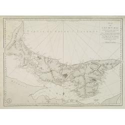
Plan de L'ile de St. Jean Au nord de l'Acadie. . .
Chart of Prince Edward Island with Charlotte town. Named after Queen Charlotte, the wife of George III.After Dutch and British sources. Engraved by Petit and edited by th...
Date: Paris, 1778
Selling price: ????
Please login to see price!
Sold in 2010
Mappa geographica Provinciæ Nova Eboraci ab Anglis New-York dictæ ex ampliori delineatione ad exactas dimensiones concinnata in arctius spatium redacta cura Claudii Josephi Sauthier cui accedit Nova Jersey ex topographicis observationibus.
Homann Heirs' edition of Sauthier's celebrated map of New York and New Jersey, made during the Revolutionary War. It also shows portions of Pennsylvania and New England. ...
Date: Nuremberg, 1778
Selling price: ????
Please login to see price!
Sold in 2011
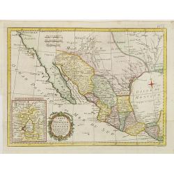
Carte du Mexique ou de la nouvelle Espagne. . .
Detailed map of Mexico, including Texas TECAS . In lower left corner inset of Mexico City. The map was prepared by William Roberts (1721-1793) in 1777 for the English edi...
Date: Paris, Panckoucke, 1778
Selling price: ????
Please login to see price!
Sold in 2011
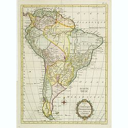
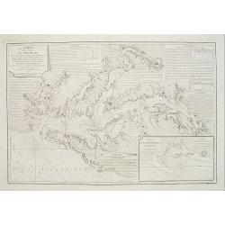
Carte de L\'Amerique Méridionale. . .
Detailed map of South America. The map was prepared by William Roberts (1721-1793) in 1777 for the English edition, in 1778 the first French edition followed, L'Histoire ...
Date: Paris, Panckoucke, 1778
Selling price: ????
Please login to see price!
Sold in 2011
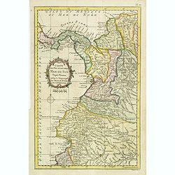
Carte des Pays situés sur la Mer du Sud. . .
Detailed map of Panama, Colombia and Ecuador. The map was prepared by William Roberts (1721-1793) in 1777 for the English edition, in 1778 the first French edition follow...
Date: Paris, Panckoucke, 1778
Selling price: ????
Please login to see price!
Sold in 2011

Representation du feu terrible à nouvelle york.
So-called optical print of New York, showing several buildings along street engulfed in flames during fire on September 19, 1776, citizens being beaten by Redcoats, and l...
Date: Augsburg, 1778
Selling price: ????
Please login to see price!
Sold in 2011

L\'entrée triumphale de troupes royales à Nouvelle York
So-called optical print of New York. Although Washington’s troops successfully retreated to Manhattan after their defeat at the Battle of Long Island, their position wa...
Date: Augsburg, 1778
Selling price: ????
Please login to see price!
Sold in 2011
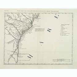
Parte Orientale della Florida, della Giorgia, e Carolina Meridionale.
Attractive map covering the coast from S.Augustine till Long Bay, including Jacksonville, Savannah. From Zatta's Atlante Novissimo.
Date: Venice, 1778
Selling price: ????
Please login to see price!
Sold in 2011
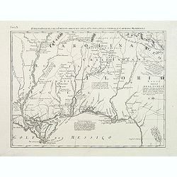
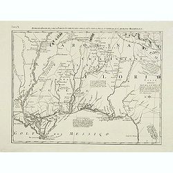
Luigiana Inglese, colla Parte Occidentale della Florida, della Giorgia, e Carolina Meridonale.
Showing the area bounded by the Mississippi River, Gulf Coast and the Southern Appalachians. The map is based on the Mitchell' map and was published in Antonio Zatta's fo...
Date: Venice, 1778
Selling price: ????
Please login to see price!
Sold in 2011
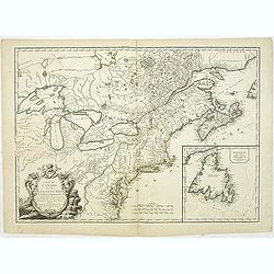
CARTE DU CANADA ET DES ETATS-UNIS de l'Amérique Septentrionale Par le S.r ROBERT DE VAUGONDY Geog. Ord.du Roi. . .
A separate issue. This is an updated version of map 1753.2 and one of the first maps to name the United States (Etats-Unis) in the title. Covers Canada east of Lake Super...
Date: Paris, 1778
Selling price: ????
Please login to see price!
Sold in 2012
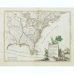
Il Canada Le Colonie Inglesi Con La Luigiana E Florida di nuouva Projezione...1778.
Map of East coast of America including the Great Lakes. The map makes mention of the upper and lower English Colonies in Louisiana. Ohio here called "Ohio ou alta Lu...
Date: Venise, 1778
Selling price: ????
Please login to see price!
Sold in 2015
Partie de l'Amerique septent? Qui comprend la nouvelle France. . .
A fine copy of this map of New Foundland, Nova Scotia and the course of the St.Lawrence to Lake Ontario in a forth state.An inset shows Bellini's famous and important map...
Date: Paris, 1755-1778
Selling price: ????
Please login to see price!
Sold in 2019
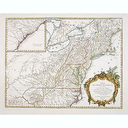
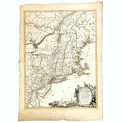
Partie De L'Amerique Septentrionale... Le Cours De L'Ohio, La N.lle Angleterre, a Nlle York, le New Jersey , La Pensyvanie, Le Maryland, Le Virginie, La Carolina...1755
From the Atlas Universel, a detailed map extending the length of the east coast from Penobscot Bay to Cape Fear and, in an inset, from Cape Fear to Fort St.Georges.This s...
Date: Paris, 1755 -1778
Selling price: ????
Please login to see price!
Sold
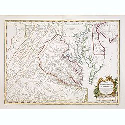
Carte de la Virginie et du Maryland. .
A third state (of 5), with Groux added to the cartouche. The late eighteenth century mapping of Virginia was dominated by Joshua Fry and Peter Jefferson's "A Map of ...
Date: Paris, 1755 - 1778
Selling price: ????
Please login to see price!
Sold in 2011

L'entrée triumphale de troupes royales à Nouvelle York.
So-called optical print of New York. Although Washington’s troops successfully retreated to Manhattan after their defeat at the Battle of Long Island, their position wa...
Date: Augsburg, 1778
Selling price: ????
Please login to see price!
Sold in 2012
Luigiana Inglese, colla Parte Occidentale della Florida, della Giorgia, e Carolina Meridonale.
Showing the area bounded by the Mississippi River, Gulf Coast and the Southern Appalachians. The map is based on the Mitchell' map and was published in Antonio Zatta's fo...
Date: Venice, 1778
Selling price: ????
Please login to see price!
Sold in 2014
Partie de l'Amerique septentrionale.. le cours de L'Ohio. . .
From the Atlas Universel, a detailed map extending the length of the east coast from Penobscot Bay to Cape Fear and, in an inset, from Cape Fear to Fort St.Georges.This i...
Date: Paris, 1755 -1778
Selling price: ????
Please login to see price!
Sold in 2013
Carte de la Virginie et du Maryland. . .
The late eighteenth century mapping of Virginia was dominated by Joshua Fry and Peter Jefferson's A Map of the Inhabited part of Virginia containing the whole Province of...
Date: Paris, 1755 -1778
Selling price: ????
Please login to see price!
Sold in 2013
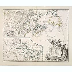
Partie de l\'Amerique septent? Qui comprend la nouvelle France. . .
A fine copy of this map of New Foundland, Nova Scotia and the course of the St.Lawrence to Lake Ontario in a fourth state.An inset shows Bellini's famous and important ma...
Date: Paris, 1755-1778
Selling price: ????
Please login to see price!
Sold in 2013
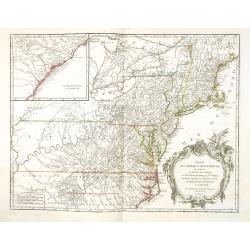
Partie de l'Amerique septentrionale.. le cours de L'Ohio. . .
From the Atlas Universel, a detailed map extending the length of the east coast from Penobscot Bay to Cape Fear and, in an inset, from Cape Fear to Fort St.Georges.This i...
Date: Paris, 1755 -1778
Selling price: ????
Please login to see price!
Sold in 2013

Der Einzug der Königlichen Völcker in Neu York. - l'Entré triumphale de troupes Royales a Nouvelle York.
A so-called optical print showing the triumphal entry of the British troops marching in triumph through the streets of New York. Engraved by F.X. Habermann (1721-1796).In...
Date: Augsburg, 1778
Selling price: ????
Please login to see price!
Sold

Debarquement des troupes engloises a nouvelle York.
A so-called optical print showing a fanciful view of British troops disembarking at New York City. Built environment includes churches, dwellings, ships, and boats. Engra...
Date: Augsburg, 1778
Selling price: ????
Please login to see price!
Sold

La destruction de la Statue royale a Nouvelle York.
So-called optical print, engraved by F.X. Habermann (1721-1796). Revolutionary War print, depicting the Sons of Liberty tearing down a statue of King Georg III at Bowling...
Date: Augsburg, 1778
Selling price: ????
Please login to see price!
Sold in 2015
Carte du Theatre de la Guerre actuel entre les Anglais et les Trieze Colonies Unies de l'Amerique Septentrionale dresse par J.B. Eliot
A fine example of J. B. Eliot's map of the United States, in its first state - which is generally regarded as the earliest map to include the title "United States&qu...
Date: Paris, 1778
Selling price: ????
Please login to see price!
Sold in 2015
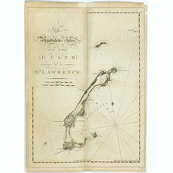
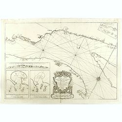
The Magdalen-Isles in the Gulph of St. Lawrence.
A chart of part of Canada taken from the "Atlantic Neptune", and marked in lower right corner "Published according to Act of Parliament Jan. The 20th 1778 ...
Date: London, 1778
Selling price: ????
Please login to see price!
Sold in 2015
![[Miramichi Bay]](/uploads/cache/35775-250x250.jpg)
[Miramichi Bay]
A chart of part of Canada taken from the "Atlantic Neptune", and marked in lower right corner "Published according to Act of Parliament Jan. The 20th 1778 ...
Date: London, 1778
Selling price: ????
Please login to see price!
Sold in 2015
![[Harbour and bay of Gaspee]](/uploads/cache/35776-250x250.jpg)
[Harbour and bay of Gaspee]
A chart of part of Canada taken from the "Atlantic Neptune", and marked in lower right corner "Published according to Act of Parliament Jan. The 20th 1778 ...
Date: London, 1778
Selling price: ????
Please login to see price!
Sold in 2015
![[The south east coast of the island of St John]](/uploads/cache/35777-250x250.jpg)
[The south east coast of the island of St John]
A chart of part of Canada taken from the "Atlantic Neptune", and marked in lower right corner "Published according to Act of Parliament Jan. The 20th 1778 ...
Date: London, 1778
Selling price: ????
Please login to see price!
Sold in 2015
![[Carigan Bay]](/uploads/cache/35778-250x250.jpg)
[Carigan Bay]
A chart of part of Canada taken from the "Atlantic Neptune", and marked in lower right corner "Published according to Act of Parliament Jan. The 20th 1778 ...
Date: London, 1778
Selling price: ????
Please login to see price!
Sold in 2015
![[Bay of Seven islands]](/uploads/cache/35779-250x250.jpg)
[Bay of Seven islands]
A chart of part of Canada taken from the "Atlantic Neptune", and marked in lower right corner "Published according to Act of Parliament Jan. The 20th 1778 ...
Date: London, 1778
Selling price: ????
Please login to see price!
Sold in 2015
![[Bay of Chaleurs]](/uploads/cache/35780-250x250.jpg)
[Bay of Chaleurs]
A chart of part of Canada taken from the "Atlantic Neptune", and marked in lower right corner "Published according to Act of Parliament Jan. The 20th 1778 ...
Date: London, 1778
Selling price: ????
Please login to see price!
Sold in 2015
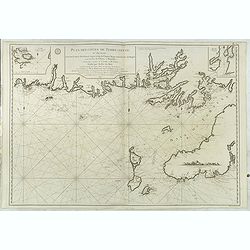
![[A chart of the N.E.Coast of Cape Breton Island]](/uploads/cache/35781-250x250.jpg)
[A chart of the N.E.Coast of Cape Breton Island]
A chart of part of Canada taken from the "Atlantic Neptune", and marked in lower right corner "Published according to Act of Parliament Jan. The 20th 1778 ...
Date: London, 1778
Selling price: ????
Please login to see price!
Sold in 2015
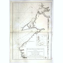
![[The south east coast of Cape Breton Island]](/uploads/cache/35782-250x250.jpg)
[The south east coast of Cape Breton Island]
A chart of part of Canada including fort Louisbourg, taken from the "Atlantic Neptune", and marked in lower right corner "Published according to Act of Par...
Date: London, 1778
Selling price: ????
Please login to see price!
Sold in 2015
![[The south east coast of Cape Breton Island]](/uploads/cache/35783-250x250.jpg)
[The south east coast of Cape Breton Island]
A chart of part of Canada taken from the "Atlantic Neptune", and marked in lower right corner "Published according to Act of Parliament Jan. The 20th 1778 ...
Date: London, 1778
Selling price: ????
Please login to see price!
Sold in 2015
![[ Moose à Becky's Beach - Maine]](/uploads/cache/36364-250x250.jpg)
[ Moose à Becky's Beach - Maine]
A chart of part of Maine's coast line taken from the "Atlantic Neptune", and marked in lower right corner "Published according to Act of Parliament April 2...
Date: London, 1778
Selling price: ????
Please login to see price!
Sold in 2015
![[Kennebec or Sagadehoc River.]](/uploads/cache/36366-250x250.jpg)
[Kennebec or Sagadehoc River.]
A chart of Sagadahoc County taken from the "Atlantic Neptune", and marked in lower right corner "Published according to Act of Parliament April 24, 1776 by...
Date: London, 1778
Selling price: ????
Please login to see price!
Sold in 2016
![[Grand Manan Island (N.B.), Maine, New Brunswick.]](/uploads/cache/36367-250x250.jpg)
[Grand Manan Island (N.B.), Maine, New Brunswick.]
A chart of part Maine and New England taken from the "Atlantic Neptune", and marked in lower right corner "Surveyed & Published according to Act of Par...
Date: London, 1778
Selling price: ????
Please login to see price!
Sold in 2015

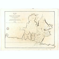
Plan du Bassin et de la Riviere du Port Royal ou Annapolis, dans l'Acadie sur la Cote Orientale de la Baie Francois . . .
Revolutionary war sea the Bay of Annapolis Royal, a small Canadian town located in the western part of Annapolis County, Nova Scotia, and was known as Port Royal until t...
Date: Paris, 1778
Selling price: ????
Please login to see price!
Sold in 2016
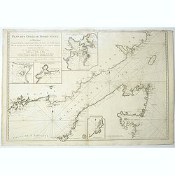
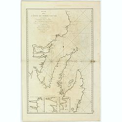
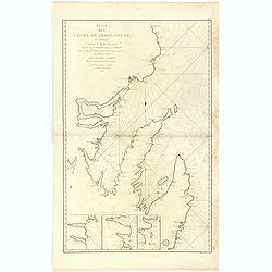
Plan des Côtes de Terre-Neuve, II ème Feuille..
Fine 1784 sea . of the southwest coast of Newfoundland, Canada, issued by the Depot de la Marine and surveyed by Captain Cook. This map, the second in this series. The F...
Date: Paris, 1778
Selling price: ????
Please login to see price!
Sold in 2016
![[Grand Bay of Pasamaquody, St. Croi.x River, Etang Harbour, Beaver Harbour, etc]](/uploads/cache/36361-250x250.jpg)
[Grand Bay of Pasamaquody, St. Croi.x River, Etang Harbour, Beaver Harbour, etc]
This superb
Date: London, ca.1778
Selling price: ????
Please login to see price!
Sold in 2015
![[Coast of Maine showing Blue Hill Bay, Penobscot Bay, Belfast Bay, Islesboro Island, Deer Island, and other islands.]](/uploads/cache/36362-250x250.jpg)
[Coast of Maine showing Blue Hill Bay, Penobscot Bay, Belfast Bay, Islesboro Island, Deer Island, and other islands.]
A chart of coast of Maine showing Blue Hill Bay, Penobscot Bay, Belfast Bay, Islesboro Island, Deer Island, and other islands taken from the "Atlantic Neptune",...
Date: London, 1778
Selling price: ????
Please login to see price!
Sold in 2015
![[Mount Desert Island and neighboring coast of Maine. ]](/uploads/cache/36363-250x250.jpg)
[Mount Desert Island and neighboring coast of Maine. ]
This superb sea chart constructed for the use of the British Navy showschart of coast of Hancock County, with Mount Desert Island and neighboring coast of Maine, taken fr...
Date: London, 1778
Selling price: ????
Please login to see price!
Sold in 2015
![[Coast of Maine showing Blue Hill Bay, Penobscot Bay, Belfast Bay, Islesboro Island, Deer Island, and other islands.]](/uploads/cache/36483-250x250.jpg)
[Coast of Maine showing Blue Hill Bay, Penobscot Bay, Belfast Bay, Islesboro Island, Deer Island, and other islands.]
A chart of coast of Maine showing Casco Bay taken from the "Atlantic Neptune", no date.Henry Stevens identified six states of the chart. This superb
Date: London, ca. 1778
Selling price: ????
Please login to see price!
Sold in 2015
![[The south east coast of Cape Breton Island]](/uploads/cache/36484-250x250.jpg)
[The south east coast of Cape Breton Island]
A chart of part of Canada taken from the "Atlantic Neptune", and marked in lower right corner "Published according to Act of Parliament Jan. The 20th 1778 ...
Date: London, 1778
Selling price: ????
Please login to see price!
Sold in 2016
![[A chart of the N.E.Coast of Cape Breton Island]](/uploads/cache/36485-250x250.jpg)
[A chart of the N.E.Coast of Cape Breton Island]
A chart of part of Canada taken from the "Atlantic Neptune", and marked in lower right corner "Published according to Act of Parliament Jan. The 20th 1778 ...
Date: London, 1778
Selling price: ????
Please login to see price!
Sold in 2015
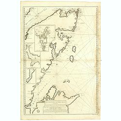
Plan des Côtes de Terre-Neuve, IV ème Feuille..
Revolutionary war sea .Relief shown by hachures. Depths shown by soundings. Below engraved seal of Depot General de la Marine. Prepared under the direction of de Maréch...
Date: Paris, 1778
Selling price: ????
Please login to see price!
Sold in 2017
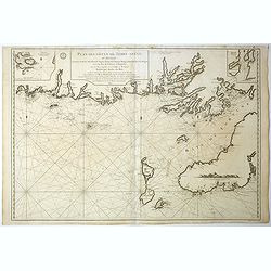
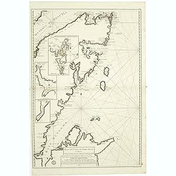
Plan des Côtes de Terre-Neuve, VI ème Feuille. . .
Revolutionary war sea of the Strait of Belle Isle (Beautiful Island) which is a waterway in eastern Canada that separates the Labrador Peninsula from the island of Newfo...
Date: Paris, 1778
Selling price: ????
Please login to see price!
Sold in 2017
Plan des Côtes de Terre-Neuve, II ème Feuille. . .
Fine 1784 sea of the southwest coast of Newfoundland, Canada, issued by the Depot de la Marine and surveyed by Captain Cook. This map, the second in this series. The Fre...
Date: Paris, 1778
Selling price: ????
Please login to see price!
Sold in 2017
![[Untitled chart of the Long Island Sound including Block Island]](/uploads/cache/39179-250x250.jpg)
[Untitled chart of the Long Island Sound including Block Island]
A chart of the end of Long Island and the area around Gardiner’s Bay. Including Gardners Island, and Block Island. Gardiner’s Island was used as a base by the British...
Date: London, 1778
Selling price: ????
Please login to see price!
Sold in 2017
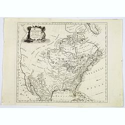
North America agreeable to the most approved maps and charts. . .
A detailed and uncommon map of North America with the Northwest labeled These Parts Are Entirely Unknown and the notations on the West Coast make various explorers' findi...
Date: London, 1778
Selling price: ????
Please login to see price!
Sold in 2017
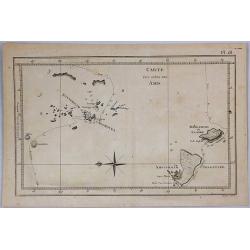
Carte des Isles des Amis.
This engraved chart depicts the Kingdom of Tonga, also known as the 'Friendly Islands', and one of the last hereditary monarchies. Cook discovered and named this group th...
Date: London, 1778
Selling price: ????
Please login to see price!
Sold in 2019
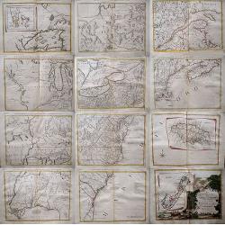
Le Colonie Unite dell´America.
Title: 'La Colonie Unite Dell' America Settentrle.' An impressive twelve-sheet map. This is Antonio Zatta's version of John Mitchell's landmark map, with some additional ...
Date: Italy, 1778
Selling price: ????
Please login to see price!
Sold in 2017
Carte du cours du fleuve de Saint Laurent depuis la Mer jusqu a Quebec. . .
Revolutionary war sea of the St Lawrence river at its estuary . With 4 insets and a large title cartouche.Relief shown by hachures. Depths shown by soundings. Below engr...
Date: Paris, 1778
Selling price: ????
Please login to see price!
Sold in 2018
Plan de la baie de Saint-Lunaire, à la côte nord-est de Terre-Neuve. . .
Revolutionary war sea of the bay de Saint-Lunaire, in New Foundland, Canada.Relief shown by hachures. Depths shown by soundings. Below engraved seal of Depot General de ...
Date: Paris, 1778
Selling price: ????
Please login to see price!
Sold in 2018
Plan des Côtes de Terre-Neuve: IXe Feuille..
Revolutionary war sea .Relief shown by hachures. Depths shown by soundings. Below engraved seal of Depot General de la Marine. Prepared under the direction of de Maréch...
Date: Paris, 1778
Selling price: ????
Please login to see price!
Sold in 2018
Plan des Côtes de Terre-Neuve: IXe Feuille..
Revolutionary war sea .Relief shown by hachures. Depths shown by soundings. Below engraved seal of Depot General de la Marine. Prepared under the direction of de Maréch...
Date: Paris, 1778
Selling price: ????
Please login to see price!
Sold in 2018
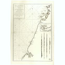
Plan des Côtes de Terre-Neuve, VII ème Feuille..
Revolutionary war sea of New Foundland.Relief shown by hachures. Depths shown by soundings. Below engraved seal of Depot General de la Marine. Prepared under the directi...
Date: Paris, 1778
Selling price: ????
Please login to see price!
Sold in 2018
Plan des Côtes de Terre-Neuve, VII ème Feuille..
Revolutionary war sea of New Foundland .Relief shown by hachures. Depths shown by soundings. Below engraved seal of Depot General de la Marine. Prepared under the direct...
Date: Paris, 1778
Selling price: ????
Please login to see price!
Sold in 2018
Plan des Côtes de Terre-Neuve, V ème Feuille..
Revolutionary war sea of New Foundland.Relief shown by hachures. Depths shown by soundings. Below engraved seal of Depot General de la Marine. Prepared under the directi...
Date: Paris, 1778
Selling price: ????
Please login to see price!
Sold in 2018

Christopher Columbus & the Discovery of America.
[Two Engraved Prints] A pair of historical copper engravings, including a portrait of Christopher Columbus, and another with Columbus’ landfall in the New World. He str...
Date: London, 1778
Selling price: ????
Please login to see price!
Sold in 2018
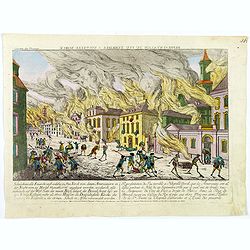
Representation du feu terrible à Nouvelle York.
So-called optical print of New York, showing several buildings along street engulfed in flames during fire on September 19, 1776, citizens being beaten by Redcoats, and l...
Date: Augsburg, 1778
Selling price: ????
Please login to see price!
Sold in 2019
Carte du Theatre de la Guerre actuel entre les Anglais et les Trieze Colonies Unies de l'Amerique Septentrionale dresse par J.B. Eliot
A fine example of J. B. Eliot's map of the United States, in its first state of which is generally regarded as the earliest map to include the title "United States''...
Date: Paris, 1778
Selling price: ????
Please login to see price!
Sold
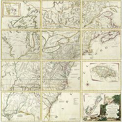
Le Colonie Unite dell America Settentr.le di Nouva Projezione . . .
A complete set of 12 maps that when joined together form a large map of North America. Shows North America west to the Mississippi and Spanish-owned Louisiana, and north ...
Date: Venise, 1778
Selling price: ????
Please login to see price!
Sold in 2019