Subscribe to be notified if similar examples become available.
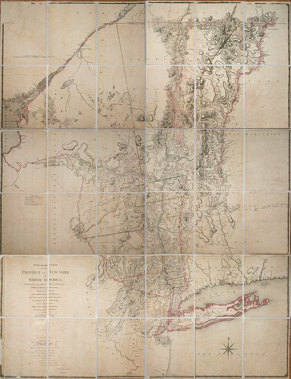
A Chorographical Map of the Province of New-York in North America, Divided into Counties, Manors, Patents and Townships ... January 1st. 1779. |
||||||||||||||||||||
|
||||||||||||||||||||
|
|
||||||||||||||||||||
|
Selling price: $ Please login to see price!
Sold in 2013 Missed this item! Add your name to our mailing list and be the first to get notified about our newly added listings. . |
My Collection + - Save and collect this or any of your favorite items in one place.
If you want to save the items permanently, please sign in or create account first. |
|||||||||||||||||||
Description
CLAUDE JOSEPH SAUTHIER’S SUPERB MAP OF THE PROVINCE OF NEW YORK IS A TOUR-DE-FORCE.
Sauthier (1736-1802) was an engineer who accompanied Governor William Tryon to North Carolina in 1761.
In 1771 he remained in his service when Tryon transferred to New York. In 1773 Sauthier was named surveyor of the Province of New York. He was commissioned to produce a survey from New York to Quebec and using the work of Bernard Ratzer along with his own surveys he produced ‘A Map of the Province of New York’ published by William Faden in 1776, on the day of the Declaration of Independence.
As war broke out he was made military surveyor and New York was in a most strategic location. Not only was the city the headquarters of British occupation during the conflict but the Province would see much of the conflict as control of the Hudson River was seen to be pivotal. It could drive a wedge between New England and the southern colonies. More accurate mapping was required and Sauthier set about the task particularly in regions less well known such as the Catskills and further upstate.
This, the resulting map, was on a scale three times greater at nearly five miles to the inch and records extraordinary detail recording individual farms and farmhouses, taverns, ferries, bridges and even the names of landholders. Amongst the latter are the 5,000 acres granted to Sauthier for his services in Norbury, Vermont. Phillips (1901) p. 505; Sellers & Van Ee (1981) 1070.
Reference: Phillips (1901) p. 505; Sellers & Van Ee (1981) 1070.
FAQ - Guarantee - Shipping
Buying in the BuyNow Gallery
This item is available for immediate purchase when a "Add to Cart" or "Inquire Now" button is shown.
Items are sold in the EU margin scheme
Payments are accepted in Euros or US Dollars.
Authenticity Guarantee
 We provide professional descriptions, condition report (based on 45 years experience in the map business)
Paulus Swaen warrants the authenticity of our items and a certificate of authenticity is provided for each acquired lot.
Condition and Coloring
We indicate the condition of each item and use our unnique HiBCoR grading system in which four key items determine a map's value: Historical Importance, Beauty, Condition/Coloring and Rarity.
Color Key
We offer many maps in their original black and white condition. We do not systematically color-up maps to make them more sellable to the general public or buyer.
Copper engraved or wood block maps are always hand colored. Maps were initially colored for aesthetic reasons and to improve readability. Nowadays, it is becoming a challenge to find maps in their original colors and are therefor more valuable.
We use the following color keys in our catalog:
Original colors; mean that the colors have been applied around the time the map was issued.
Original o/l colors; means the map has only the borders colored at the time of publication.
Colored; If the colors are applied recently or at the end of the 20th century.
Read more about coloring of maps [+]
Shipping fee
A flat shipping fee of $ 30 is added to each shipment by DHL within Europe and North America. This covers : International Priority shipping, Packing and Insurance (up to the invoice amount).
Shipments to Asia are $ 40 and rest of the world $50
We charge only one shipping fee when you have been successful on multiple items or when you want to combine gallery and auction purchases.
Read more about invoicing and shipping
FAQ
Please have a look for more information about buying in the BuyNow gallery
Many answers are likely to find in the general help section.
My Collection+
![]()
With My Collection+ you can collect all your favorite items in one place. It is free, and anyone can create his or her virtual collection.
Unless you are logged in, the item is only saved for this session. You have to be registed and logged-in if you want to save this item permanently to My Collection+.
Read More[+]
Register here, it is free and you do not need a credit card.
Add this item to
My Collection+
or click the following link to see My Collection+.
| Digital Image Download | |
|
Paulus Swaen maintains an archive of most of our high-resolution rare maps, prints, posters and medieval manuscript scans. We make them freely available for download and study. Read more about free image download |
Click the image for a free small image download. |
In accordance with the EU Consumer Rights Directive and habitually reside in the European Union you have the right to cancel the contract for the purchase of a lot, without giving any reason.
The cancellation period will expire 14 calendar days from the day after the date on which you or a third party (other than the carrier and indicated by you) acquires, physical possession of the lot. To exercise the right to cancel you must inform Paulus Swaen Inc, of your decision to cancel this contract by a clear statement (e.g. a letter sent by post, or e-mail (amsterdam@swaen.com).
To meet the cancellation deadline, it is sufficient for you to send your communication concerning your exercise of the right to cancel before the cancellation period has expired.
