Browse Listings in America
![[Lot of 9 maps and prints]. Kaart van Brasil en de Aller-heiligen Baay waar aan de Hoofdstad legt van Brazil.](/uploads/cache/19736-250x250.jpg)
[Lot of 9 maps and prints]. Kaart van Brasil en de Aller-heiligen Baay waar aan de Hoofdstad legt van Brazil.
[Lot of 9 maps and prints of Brasil].- Kaart van de Aller-heiligen Baay waar aan de Hoofdstad legt van Brazil. - Carte du Bresil Prem. Partie- Suite du Bresil- Suite du ...
Date: Amsterdam, ca 1770
Selling price: ????
Please login to see price!
Sold in 2023
Partie de la carte du Captaine Cluny..
From Diderot's Encyclopaedia . Based on Captain Cluny's map of 1769 published in London in American Traveller .
Date: Paris 1771
Selling price: ????
Please login to see price!
Sold
Carte du Paraguay et des Pays voisin.
Jaques Nicolas Bellin (1702-720) was the most important French hydrographer of the 18th century. Sea-atlas 'Hydrographique Français' , 1756-65, atlas to accompany Prévo...
Date: Amsterdam, 1771
Selling price: ????
Please login to see price!
Sold
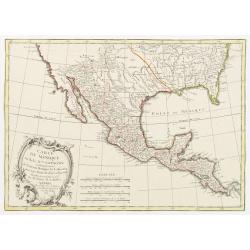
Carte du Mexique ou de la Nlle. Espagne Contenant aussi le Nouveau Mexique, la Californie, avec une Partie des Pays adjacents..
Attractive map covering the region from the Chesapeake Bay through California with Mexico and Central America.Excellent detail, particularly of the Jesuit missions in Mex...
Date: Paris, 1771
Selling price: ????
Please login to see price!
Sold in 2022
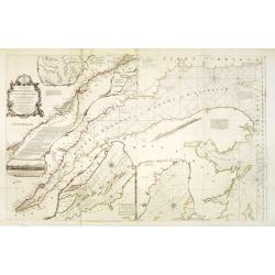
An exact chart of the River St. Laurence, from Fort Frontenac to the Island of Anticosti, shewing the soundings, rocks, shoals &c.
Published in "A General Atlas", with dedication to Jn. Montague, Earl of Sandwich. Dated 1771. This is the fourth state of five. With five insets. A chart of th...
Date: London, Robert Sayer, 1771
Selling price: ????
Please login to see price!
Sold in 2013

The British Troops entering the Breach of the Moro Castle Engraved for Mountagues History of England.
The scene "CUBA: BATTLE OF HAVANA", British troops entering the breach in the fortress, Morro Castle, during the Battle of Havana, in the July of 1762. Engraved...
Date: London, 1771
Selling price: ????
Please login to see price!
Sold in 2017
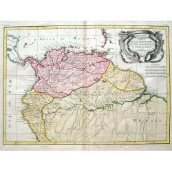
Carte De La Terre Ferme, de la Guyane, et du Pays des Amazones...
Fine map of the northern part of South America, including Aruba, Bonaire, Curacao, Trinidad, Columbia, Peru, Venezuela, Ecuador, Guyana, and the northern part of Brazil. ...
Date: Paris, 1771
Selling price: ????
Please login to see price!
Sold in 2018
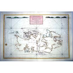
CARTE REDUITE DES ISLES MALOUINES OU .. ISLES DE FALKLAND 1771
Large-scale nautical chart of the Falkland islands with rhumb lines, soundings and anchorages, detailed chart with depth soundings and the tracks of recent French and Eng...
Date: Paris, 1771
Selling price: ????
Please login to see price!
Sold in 2021
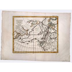
Partie de la carte du Capitaine Cluny? publié en 1769.
A map of North America with a supposedly northwest passage.
Date: Paris, 1772
Selling price: ????
Please login to see price!
Sold
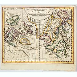
Carte Generale des Decouvertes de l' Amiral de Fonte representant la grande probabilite d'un Passage au Nord Ouest
The probably most extravagant of all the Northwest Passage maps after Thomas Jefferys, a passionate believer in the northern route to Asia and prepared this map to show t...
Date: Paris, 1772
Selling price: ????
Please login to see price!
Sold
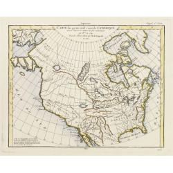
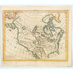
Carte des parties nord est ouest de L'Amerique..
Map of North America, as well as Canada & Alaska. California & the Pacific Northwest coast to Alaska is still speculative, whereas the east coast is depicted from...
Date: Paris 1772
Selling price: ????
Please login to see price!
Sold
Carte des nouvelles découvertes/ Extrait d\'une Carte Japonoise de l\'Universe.
Gilles Robert de Vaugondy (!686-1766) and son Didier (1723-86), Paris geographers and publishers. Gilles succeedded Pierre Moulart Sanson in 1730. "Atlas Portatif&qu...
Date: Paris, 1772
Selling price: ????
Please login to see price!
Sold in 2017
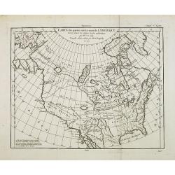
Carte des parties nord et ouest de l' Amerique. . .
Map of North America, as well as Canada & Alaska. California & the Pacific Northwest coast to Alaska is still speculative, whereas the east coast is depicted from...
Date: Paris, 1772
Selling price: ????
Please login to see price!
Sold in 2014
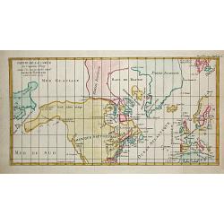
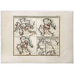
Carte de la partie Septentrionale et Orientale .. (5 maps on one sheet)
Five maps on one sheet, showing California, Alaska and Siberia and Japan.Map I showing Alaska, California as a peninsular, eastern tip of Japan with a curious Islade Plat...
Date: Paris, 1772
Selling price: ????
Please login to see price!
Sold in 2023
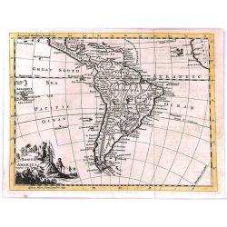
South America
"South America" by Thomas Jefferys, published in “A New Geographical and Historical Grammar” in London in 1772.Thomas Jefferys (c.1719–1771), "Geogra...
Date: London, 1772
Selling price: ????
Please login to see price!
Sold in 2017
Carte des parties Nord et Est de L'Asie...
Interesting map of the northern coastline of Russia, the eastern coast of Asia with Korea, Japan, and China, and a bit of the coast of America called Anian. With four sm...
Date: Paris, 1772
Selling price: ????
Please login to see price!
Sold in 2016
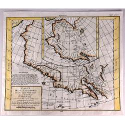
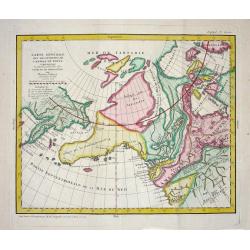
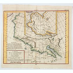
Carte de la Californie et des Pays Nord-Ouest Separes de l'Asie par le Detroit d'Aman.
An interesting study in the comparative cartography of the West Coast of North America in California. The work consists of extracts from two maps, both reportedly done b...
Date: Paris, 1772
Selling price: ????
Please login to see price!
Sold in 2017
Carte de la Californie Suivant.
A historically important depiction of the 5 most influential cartographic depictions of California, showing the evolution of how California was mapped between 1604 and 17...
Date: Paris, 1772
Selling price: ????
Please login to see price!
Sold in 2017
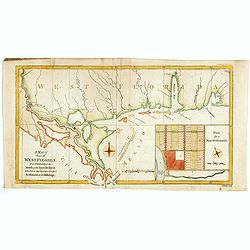
A Map of Part of West Florida from Pensacola to the Mouth of the Iberville River, with a view to shew the proper spot for a Settlement on the Mississipi.
Uncommon map of the Mississippi delta and coastal regions of Mississippi, Alabama and the panhandle of Florida., from the February 1772 edition of Gentleman's Magazine, w...
Date: London 1772
Selling price: ????
Please login to see price!
Sold in 2017
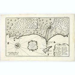
De Haven van Callao in de Stille of Zuid-Zee. . .
An attractive plan of the Peruvian port of Callao, and her surrounds, including Lima, some 15 km's to the east. From a Dutch edition of an important report of a French/Du...
Date: Amsterdam, ca 1772
Selling price: ????
Please login to see price!
Sold in 2019
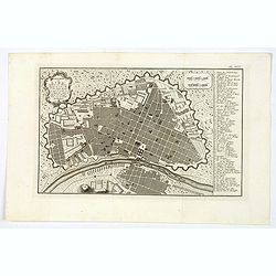
Platte-Grond van Lima Hoofdstadt van Peru. . .
An attractive plan of the Peruvian capital of Lima. From a Dutch edition of an important report of a French/Dutch expedition through South America in 1772. The map depict...
Date: Amsterdam, ca 1772
Selling price: ????
Please login to see price!
Sold in 2023
![[Untitled] De Stad Louisburg of van Kaap Breton. . .](/uploads/cache/43969-250x250.jpg)
[Untitled] De Stad Louisburg of van Kaap Breton. . .
A plan of the French Fortress of Louisbourg, and the immediate surrounds. The Fortress today is a National Historic Site of Canada, and the location of a one-quarter part...
Date: Amsterdam, ca 1772
Selling price: ????
Please login to see price!
Sold in 2019
CARTE GENERALE DES DECOUVERTES de l'Amiral de Fonte, et autres navigateurs. . .
An extremely interesting map of the Northwest Coast, showing De L'Isle's conjectural northwest coast, based upon De Font and Russian Discoverers, including the Bay of the...
Date: Paris, 1772
Selling price: ????
Please login to see price!
Sold in 2019
CARTE GENERALE DES DECOUVERTES de l'Amiral de Fonte,representant la grande possibilite d'un PASSAGE AU NORD OUEST.
A fascinating map of the Northwestern part of America, illustrating the reports of De L'Isle of the Russian discoveries in the region prior to 1750, which he obtained dur...
Date: Paris, 1772
Selling price: ????
Please login to see price!
Sold in 2019
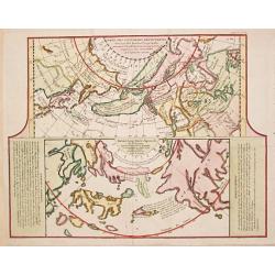
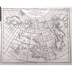
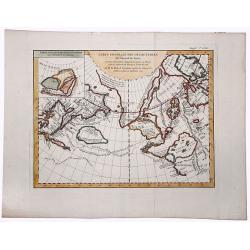
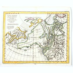
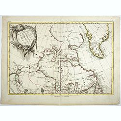
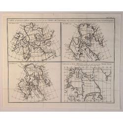
Carte qui represente les differentes connoissances que L'on a eues des Terres Arctiques depuis 1650. . . CARTE DE LA BAYE D' HUDSON.
A beautiful set of four maps of the Hudson, Button and Baffin Bay regions, Davis Straits and the Coast Labrador, showing the evolution of cartography and discoveries of t...
Date: Paris, 1772
Selling price: ????
Please login to see price!
Sold in 2019
Carte des parties nord et ouest de L' Amerique. . .
An interesting map of North America, based upon an earlier map by Thomas Engel. His map of North America was issued in his 'Memoires Observations Geographique' in 1765, a...
Date: Paris, 1772
Selling price: ????
Please login to see price!
Sold in 2020
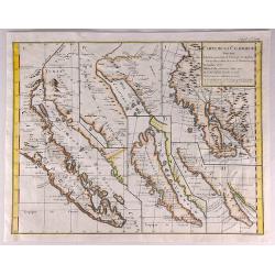
Carte de la Californie et des Pays Nord Ouest separes de L'Asie par le Detriot d'Anian. . .
Two map shown. The larger map prominently shows the Strait of Anian, Anian Regnum, Quivira Regnum, the Sierra Nevada, Nova Albion, Tontonteac Regnum, Tolm Regnum and a co...
Date: Paris, 1772
Selling price: ????
Please login to see price!
Sold in 2020
Carte generale des Decouvertes de L'Amiral de Fonte. . .
An interesting map of the northwest coast, showing de L'Isle's conjectural northwest coast, based upon that of de Font and Russian Discoverers, including the Bay of the W...
Date: Paris, 1772
Selling price: ????
Please login to see price!
Sold in 2020
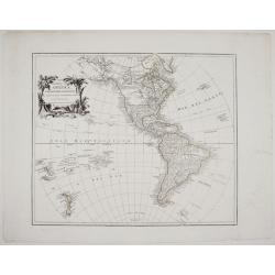
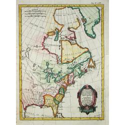
Mapa general de América ó hemisferio occidental. . .
A rare and very detailed map of Americas and the Western Hemisphere. With a decorative cartouche flanked by two trees, an exotic bird and a crocodile.
Date: Madrid, 1772
Selling price: ????
Please login to see price!
Sold in 2020
General Map of the Discoveries of Admiral de Fonte representing the great probability of a Passage to the North West by Thomas Jefferys. . .
An attractive and interesting map issued in the supplement to Diderot's 'Encyclopedie' as part of the series of ten maps by de Vaugondy illustrating the then-current view...
Date: Paris, 1772
Selling price: ????
Please login to see price!
Sold in 2020
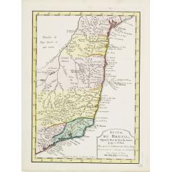
Suite du Bresil ..
Uncommon edition of this accurate map of part of Brazil.From Atlas Portatif pour servir a l'intelligence de l'Histoire Philosophique et Politique des etablissements et du...
Date: Amsterdam, 1773
Selling price: ????
Please login to see price!
Sold in 2016
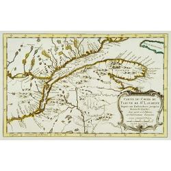
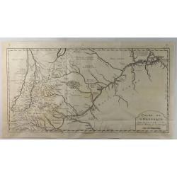
Carte du cours du Fleuve de St.Laurent..
Uncommon edition of this accurate map showing the lower St.Laurence. Second state.From Atlas Portatif pour servir a l'intelligence de l'Histoire Philosophique et Politiqu...
Date: Amsterdam 1773
Selling price: ????
Please login to see price!
Sold
Suite du cours du Fleuve de St.Laurent..
Uncommon edition of this accurate map showing the lower the upper St.Laurence. Second state. From Atlas Portatif pour servir a l'intelligence de l'Histoire Philosophique ...
Date: Amsterdam, 1773
Selling price: ????
Please login to see price!
Sold in 2013
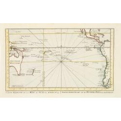
Carte réduite de la Mer du Sud.. Gereduceerde kaart van de Zuider-zee..
Intriguing map of the Pacific. Partial outline of Australia, Nouvelle Zeelande, Nouvelle Guinee, North America and the west coast of South America. With title in French a...
Date: Amsterdam 1773
Selling price: ????
Please login to see price!
Sold
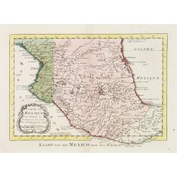
Carte du Mexique.
Uncommon edition of this fine map of Mexico.From Atlas Portatif pour servir a l'intelligence de l'Histoire Philosophique et Politique des etablissements et du commerce de...
Date: Amsterdam, 1773
Selling price: ????
Please login to see price!
Sold
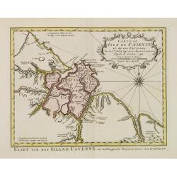
Carte de L'Isle de Caiene et de ses environs.
Uncommon edition of this accurate map of Cayenne.From Atlas Portatif pour servir a l'intelligence de l'Histoire Philosophique et Politique des etablissements et du commer...
Date: Amsterdam, 1773
Selling price: ????
Please login to see price!
Sold in 2022
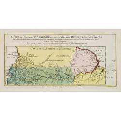
Carte du Cours du Maragnon ou .. Amazones..
Uncommon edition of this map of the river Amazon.From Atlas Portatif pour servir a l'intelligence de l'Histoire Philosophique et Politique des etablissements et du commer...
Date: Amsterdam, 1773
Selling price: ????
Please login to see price!
Sold in 2018
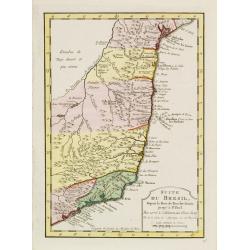
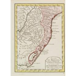
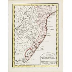
Suite du Bresil Depuis la Baie de Tous les Saints..
Uncommon edition of this accurate map of part of Brazil, from San Salvador till Rio de Janeiro and S.Paulo.From Atlas Portatif pour servir a l\'intelligence de l\'Histoir...
Date: Amsterdam, 1773
Selling price: ????
Please login to see price!
Sold in 2008
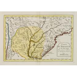
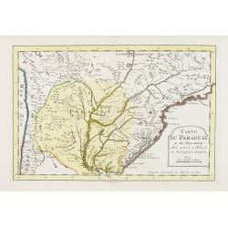
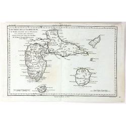
Carte du Paraguay et des Pays voisins..
Uncommon edition of this fine map of Paraguay.From Atlas Portatif pour servir a l'intelligence de l'Histoire Philosophique et Politique des etablissements et du commerce ...
Date: Amsterdam, 1773
Selling price: ????
Please login to see price!
Sold in 2017
Suite du Bresil ..
Uncommon edition of this accurate map of part of Brazil.From Atlas Portatif pour servir a l\'intelligence de l\'Histoire Philosophique et Politique des etablissements et ...
Date: Amsterdam 1773
Selling price: ????
Please login to see price!
Sold in 2008
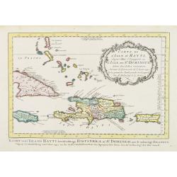
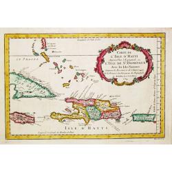
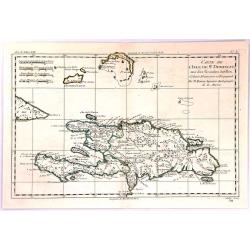
Carte de L'Isle d'Hayti, Aujour d'hui.. St.Domingue..
Uncommon edition of this fine map of Hispaniola and the neighboring islands Jamaica, Caymans, Porto Rico and eastern part of Cuba.Hispaniola divided into the five major c...
Date: Amsterdam, 1773
Selling price: ????
Please login to see price!
Sold
Carte réduite du Détroit de Magellan. . .
Uncommon edition of this fine map southern part of South America with Straits Magellan. In lower right engraved "27."From Atlas Portatif pour servir a l'intelli...
Date: Amsterdam, 1773
Selling price: ????
Please login to see price!
Sold in 2011
Carte du Paraguay et des Pays voisins..
Uncommon edition of this fine map of Paraguay. In lower right engraved "28."From Atlas Portatif pour servir a l'intelligence de l'Histoire Philosophique et Poli...
Date: Amsterdam, 1773
Selling price: ????
Please login to see price!
Sold in 2011
Suite du Bresil Depuis la Baie de Tous les Saints..
Uncommon edition of this accurate map of part of Brazil, from San Salvador till Rio de Janeiro and S.Paulo. In lower right engraved "29b."From Atlas Portatif po...
Date: Amsterdam, 1773
Selling price: ????
Please login to see price!
Sold
Suite du Bresil..
Uncommon edition of this accurate map of part of Brazil. In lower right engraved "29c."From Atlas Portatif pour servir a l'intelligence de l'Histoire Philosophi...
Date: Amsterdam, 1773
Selling price: ????
Please login to see price!
Sold
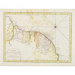
Carte de La Guiane..
Uncommon edition of this accurate map of part of Brazil. In lower right engraved "32."From Atlas Portatif pour servir a l'intelligence de l'Histoire Philosophiq...
Date: Amsterdam, 1773
Selling price: ????
Please login to see price!
Sold in 2022
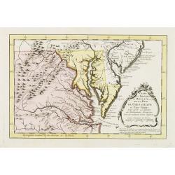
Carte de la Virginie et du Maryland, ou de la Baie de Chesapeack et pays voisins..
Uncommon edition of this accurate map showing Chesapeake Bay and part of New Jersey, Philadelphia and part of Virginia. In lower right engraved "39."From Atlas ...
Date: Amsterdam, 1773
Selling price: ????
Please login to see price!
Sold
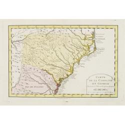
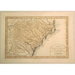
Carte de la Caroline et Georgie..
Uncommon edition of this early map of the Carolinas. In lower right engraved "40."From Atlas Portatif pour servir a l'intelligence de l'Histoire Philosophique e...
Date: Amsterdam, 1773
Selling price: ????
Please login to see price!
Sold
Carte de l' Isle d' Hayti, Aujourd'hui l' Espagnole, ou l' Isle de St. Dominique, Avec les Isles voisines.
Jaques Nicolas Bellin (1702-720) was the most important French hydrographer of the 18th century. Sea-atlas 'Hydrographique Français' , 1756-65, atlas to accompany Prévo...
Date: Amsterdam, 1773
Selling price: ????
Please login to see price!
Sold in 2008
Suite du Bresil . . .
Uncommon edition of this accurate map of part of Brazil.From Atlas Portatif pour servir a l'intelligence de l'Histoire Philosophique et Politique des etablissements et du...
Date: Amsterdam, 1773
Selling price: ????
Please login to see price!
Sold in 2022
![Vue des Indiens de la Terre de Feu dans leurs huttes. [Tome II Pl. 7.]](/uploads/cache/26105-250x250.jpg)
Vue des Indiens de la Terre de Feu dans leurs huttes. [Tome II Pl. 7.]
Family scene in a Patagonian hut. From the French edition of James Cook's first voyage entitled Relation des voyages entrepris par ordre de sa Majesté Britannique actuel...
Date: Paris, 1773
Selling price: ????
Please login to see price!
Sold in 2012
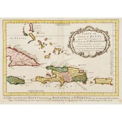
Carte de L'Issle d'Hayti, Aujour d'hui.. St.Domingue..
Uncommon edition of this fine map of Hispaniola and the neighboring islands Jamaica, Caymans, Porto Ricco and eastern part of Cuba. Hispaniola divided into the five major...
Date: Amsterdam, 1773
Selling price: ????
Please login to see price!
Sold in 2020
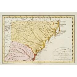
Carte de la Caroline et Georgie. . .
Uncommon edition of this early map of the Carolinas.From Atlas Portatif pour servir a l'intelligence de l'Histoire Philosophique et Politique des etablissements et du com...
Date: Amsterdam, 1773
Selling price: ????
Please login to see price!
Sold in 2016
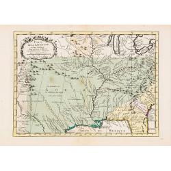
Carte de la Louisiane et Pays Voisins..
Uncommon edition of this accurate map centered on Louisiana and extending eastwards as far as the Atlantic seacoast. In lower right engraved "33."From Atlas Por...
Date: Amsterdam, 1773
Selling price: ????
Please login to see price!
Sold in 2019
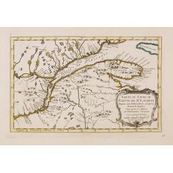
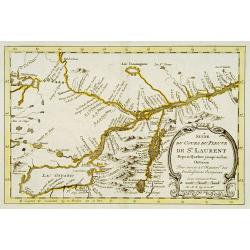
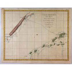
Carte du cours du Fleuve de St.Laurent Depuis son Embouchure..
Scarce edition of this accurate map showing the lower St.Laurence, including Quebec. Second state. In lower right engraved "34b."From Atlas Portatif pour servir...
Date: Amsterdam, 1773
Selling price: ????
Please login to see price!
Sold in 2014
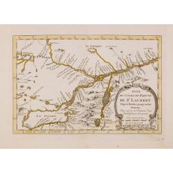
Suite du cours du Fleuve de St.Laurent Depuis Quebec jusqu'au Lac Ontario..
Scarce edition of this accurate map showing the upper St.Laurence. In lower right engraved "34c."From Atlas Portatif pour servir a l'intelligence de l'Histoire ...
Date: Amsterdam, 1773
Selling price: ????
Please login to see price!
Sold
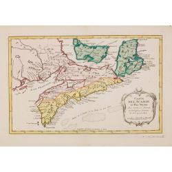
Carte de L'Acadie et Pais Voisins. . .
Scarce edition of this fine map of Maritime Canada. This is an intermediate state between Kershaw 785/786: the map has an engraved nr. 37.Louisburg and Baie Chedabouctou ...
Date: Amsterdam, 1773
Selling price: ????
Please login to see price!
Sold in 2014

Carte Particuliere d'une Partie des Riviers de Berbice et de Caroje, Pour L'Intelligence de la Relation Touchant l Revolt des Negres en 1763
Plan of Berbice, Surinam at the time of the slave revolt of 1763. The slaves revolted and forced the plantation owners out of the country.
Date: Amsterdam, 1773
Selling price: ????
Please login to see price!
Sold in 2018
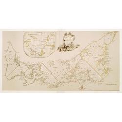
Partie de l'Amerique Septentrionale.. Canada, la Louisiane...
Interesting map of the eastern part of Canada with Hudson Bay, Baffin Bay and Greenland.
Date: Paris/ Bordeaux, 1773
Selling price: ????
Please login to see price!
Sold in 2018
![[Untitled] but Chart of the Track of the Dolphin, Tamar, Swallow & Endeavour through the South Seas & the track of M.Bougainville. . .](/uploads/cache/42647-250x250.jpg)
[Untitled] but Chart of the Track of the Dolphin, Tamar, Swallow & Endeavour through the South Seas & the track of M.Bougainville. . .
The map is one of a three part set, comprising of three sheets covering the world, and detailing Cook's first voyage. This is the Americas map is (part 1) and was issued ...
Date: London, 1773
Selling price: ????
Please login to see price!
Sold in 2020
Cours de L'Orenoque Depuis ses Sources Jusqu'a la Mer.
An uncommon copper engraved map of the mouth of the Orinoco River, in South America. The map covers the countries of Colombia and Venezuela. A simple block-style title c...
Date: Paris, 1773
Selling price: ????
Please login to see price!
Sold in 2020
Carte de la Caroline et Georgie.
Fine hand-colored Bellin atlas map of the Southern States Georgia and Carolina from Curriluk Pass to Kekil Island. Out of "Atlas Portalif ". A plain title carto...
Date: Paris, 1773
Selling price: ????
Please login to see price!
Sold in 2020
Carte Qui Represente les Differentes Connoissances que Lion Eues des Terres Arctiques. . .
This magnificent original copper-plate engraved antique maps of 4 different time based views of Hudsons Bay & Eastern Canada by Robert De Vaugondy was engraved in 177...
Date: Paris, 1773
Selling price: ????
Please login to see price!
Sold in 2020
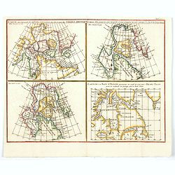
Carte qui represente les différentes connoissances que l'on a eues des Terres Arctiques depuis 1650 jusqu'en 1747. . .
A fascinating group of four maps on the one sheet to illustrate the cartography of Sanson in 1750, Delisle in 1700 and 1703 plus that of the famous Arctic explorer Henry ...
Date: Paris, 1773
Selling price: ????
Please login to see price!
Sold in 2020
Partie du Nord de l' Amerique Septentrionale.
Rigobert Bonne (1727-1795), French cartographer. His maps are found in a.o. Atlas Moderne (1762), Raynal's Histoire Philos. du Commerce des Indes (1774) and Atlas Encyclo...
Date: Paris, 1774
Selling price: ????
Please login to see price!
Sold
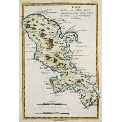
Carte de l\'Isle de la Martinique.
Rigobert Bonne (1727-1795), French cartographer. His maps are found in a.o. Atlas Moderne (1762), Raynal's Histoire Philos. du Commerce des Indes (1774) and Atlas Encyclo...
Date: Paris, 1774
Selling price: ????
Please login to see price!
Sold in 2010
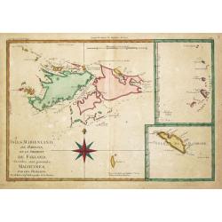
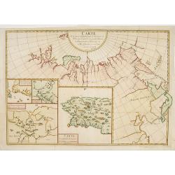
Isles Maidenland, de Hawkins et le Détroit de Falkland. / Isle de Géorgie. / Terre de Sandwich.
Rigobert Bonne (1727-1795), French cartographer. His maps are found in a.o. Atlas Moderne (1762), Raynal's Histoire Philos. du Commerce des Indes (1774) and Atlas Encyclo...
Date: Paris, 1774
Selling price: ????
Please login to see price!
Sold
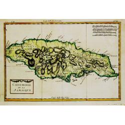
Carte de l''Isle de la Jamaique.
Rigobert Bonne (1727-1795), French cartographer. His maps are found in a.o. Atlas Moderne (1762), Raynal's Histoire Philos. du Commerce des Indes (1774) and Atlas Encyclo...
Date: Paris, 1774
Selling price: ????
Please login to see price!
Sold
![Port Gallant et Baye Fortescue / Port Eimine /Baye de Wood / Baye et Havre de Cordes. [Tome I Pl. 3.]](/uploads/cache/25889-250x250.jpg)
Port Gallant et Baye Fortescue / Port Eimine /Baye de Wood / Baye et Havre de Cordes. [Tome I Pl. 3.]
Four charts on one sheet of Port Famine, Wood's Bay, Port Gallant and Fortescue Bay, Cordes Bay and Harbour. This print is taken from the first French edition of James Co...
Date: Paris, 1774
Selling price: ????
Please login to see price!
Sold in 2012
![Carte de Maidenland ou de la Virginie de Hawkins, Découverte par Sir Richard Hawkins en 1574, et du Canal Falkland . . . [Tome I Pl.7.]](/uploads/cache/25892-250x250.jpg)
Carte de Maidenland ou de la Virginie de Hawkins, Découverte par Sir Richard Hawkins en 1574, et du Canal Falkland . . . [Tome I Pl.7.]
Chart shows the Falkland Islands and the Falkland Straits discovered by Sir Richard Hawkins in 1574. Shows many harbors, channels, capes, bays, shoals, islands, rocks, so...
Date: Paris, 1774
Selling price: ????
Please login to see price!
Sold in 2021
![Vue du Côté N.O. de Masafuero. [Tome I Pl. 8.]](/uploads/cache/25893-250x250.jpg)
Vue du Côté N.O. de Masafuero. [Tome I Pl. 8.]
Coastline views of the North West of Masafuero. This print is taken from the first French edition of James Cook's first voyage entitled Relation des voyages entrepris par...
Date: Paris, 1774
Selling price: ????
Please login to see price!
Sold in 2012
![Entrevue du Commodore Byrou avec les Patagons. [Tome I Pl. 6.]](/uploads/cache/26104-250x250.jpg)
Entrevue du Commodore Byrou avec les Patagons. [Tome I Pl. 6.]
Commodore Byron in talks with the native tribes of Patagonia. From the French edition of James Cook's first voyage entitled Relation des voyages entrepris par ordre de sa...
Date: Paris, 1774
Selling price: ????
Please login to see price!
Sold in 2013
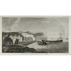
Entrevue du Commodore Byron avec les Patagons.
From the French edition of James Cook's first voyage entitled Relation des voyages entrepris par ordre de sa Majesté Britannique actuellement régnante pour faire des d�...
Date: Paris, 1774
Selling price: ????
Please login to see price!
Sold in 2010
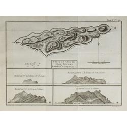
Carte et Vues de l'Isle Pitcairn.
From the French edition of James Cook's first voyage entitled Relation des voyages entrepris par ordre de sa Majesté Britannique actuellement régnante pour faire des d�...
Date: Paris, 1774
Selling price: ????
Please login to see price!
Sold in 2010
Carte de L'Isle de St. Domingue une des Grande Antilles
A copperplate map of the island of Hispaniola by Rigobert Bonne in 1774. With the two sovereign states of the Dominican Republic and Haiti. Also with nearby Caicos and th...
Date: Paris, 1774
Selling price: ????
Please login to see price!
Sold in 2017
Les Isles de la Guadeloupe, de Marie Galante, de la Désirade et Celles des Saintes...
A map of the French island of Guadeloupe, together with the islands in the vicinity, by Bonne, published in Paris in 1774. Engraved by Dien.Rigobert Bonne (1727-1795), wa...
Date: Paris, 1774
Selling price: ????
Please login to see price!
Sold in 2020
Carte des Decouvertes Faites dans la Mer Pacifique sur le Vaiseau de Poi La Resolution Commande par le Capitaine Cook en 1774.
This fine copper engraved map shows New Caledonia Island in the upper left, and the New Hebrides in the lower right. The map is west oriented so that north is on the righ...
Date: London, 1774
Selling price: ????
Please login to see price!
Sold in 2018
A Map of the Island of St. John in the Golf of St. Laurence
Based on the surveys of Captain Samuel Holland. Published in Thomas Jefferys' "The American Atlas." Detailed map with compass roses and system of rhumb lines, s...
Date: London 1775
Selling price: ????
Please login to see price!
Sold
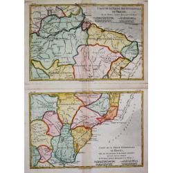
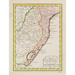
Carte de la Partie Septentrionale / Méridionale du Brésil.
Rigobert Bonne (1727-1795), French cartographer. His maps are found in a.o. Atlas Moderne (1762), Raynal's Histoire Philos. du Commerce des Indes (1774) and Atlas Encyclo...
Date: Paris, c, 1775
Selling price: ????
Please login to see price!
Sold
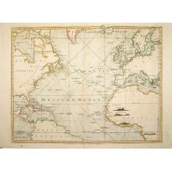
A Chart of the Atlantic Ocean. 1 sheet.
A very fine chart centered on the Atlantic ocean, including a part of western Europe and America continent. London: Printed and sold by Robert Sayer, No. 53 in Fleet Stre...
Date: London, 1775
Selling price: ????
Please login to see price!
Sold in 2008