Recently Listed Listings in Europe
![Malines. [Mechelen]](/uploads/cache/13125-250x250.jpg)
Malines. [Mechelen]
A very RARE panoramic town view of Mechelen, including a numbered legend in the left lower corner.Published by the brothers Chéreau, active in Paris at rue st.Jacques au...
Date: Paris, c.1720
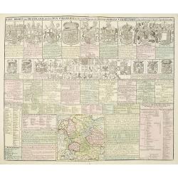
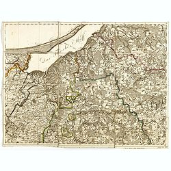
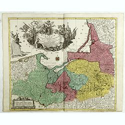
Kort Begryp van Duytsland, de drie Ryx Collegien in hunne Wapens en Zittingen. Kreits Verelingen en Aantekenigen door C. Specht't Utrectht.
Second state of this decorative table of family escutcheons, crests and coats of arms, for various German and Dutch princes and nobles of the 16th, 17th and 18th Centurie...
Date: Amsterdam, 1720

Mastric ou Maëstricht, Ville du Brabant-Hollandois. . .
A very decorative and extremely rareof Maastricht, including a numbered key (1-23) in lower part. Engraved by Pierre-Alexandre Aveline. With "Fait par Aveline avec p...
Date: Paris, ca.1692
![Ulma Folio CXCI [With view of Ulm.]](/uploads/cache/29713-250x250.jpg)
Ulma Folio CXCI [With view of Ulm.]
Double-page panoramic view of Ulm.An imaginary view, however, is the earliest obtainable view of this period.Two pages from the richest illustrated Incunabel, the famou...
Date: Nuremberg, 12 July 1493

De Texel Stroom .. vant Marsdiep./ Caarte van De Mase...
Two decorative charts on one sheet, one depicting Texel and the entrance of the Zuider Zee with an inset showing the north coast of West-Friesland, the other depicting th...
Date: Amsterdam, 1660

Tabula ducatus Limburch et comitatus Valckenburch. . .
The map describes the southern part of Limburg and reaches into Belgium (Liege, Verviers) and Germany. With two very decorative cartouches.
Date: Amsterdam, 1690

Prospectus Castelli Boxtel.
One of the earliest views of the Castle of Boxtel. Engraved by Henricus Cause. With a description in Latin, French and Dutch.
Date: Amsterdam, 1695

Prospectus veteris castelli Graviae.
One of the earliest views of the ancient Castle of Grave. Engraved by Casper Bouttats. With a description in Latin, French and Dutch.
Date: Amsterdam, 1695

Kasteel Croij.
Decorative lithography of the castle of Croij.
Date: Den Haag, 1880

Ruremunda Gelriae opp.
A bird's eye town-plan of the town of Roermond. From the first Dutch translation of Guicciardini's description of the Netherlands.
Date: Amsterdam, 1612

Zelandia Comitatus.
Based on the map by Van Deventer. For the first time a road connection between Flushing, Middelburg and Arnemuiden is shown. Mercator pays much attention to the area of s...
Date: Amsterdam, 1630

't dorp Aalst.
Rare print of the old church of Aalst (near Eindhoven), from Vaderlandsche gezichten of afbeeldingen.. by J.Bulthuis, printed by H.Gartman in Amsterdam.
Date: Amsterdam, 1786 / 1792

Pascaert van Engelant Van t'Voorlandt tot aen Blakeney waer in te sien is de mont vande Teemse.
Two charts on one sheet. One decorative sea chart of the southeast coast of England with an inset of the Thames till London, embellished with two title cartouches, a ship...
Date: Amsterdam, 1666

Cust van Hollant Tussen de Maes ende Texel.
Uncommon chart of the coast of Holland, including the southern tip of Texel. East at the top. Two fine compass cards, soundings and a large Bree Veerthien offshore.Piete...
Date: Amsterdam, 1666

Military map of the countries between Odessa & Perekop with the stations of the Russian forces.
Rare colored linen-backed map showing Russian troop positions and Odessa Batteries. On the inside of the cover a list of "Wyld's list of recent publications : seat o...
Date: London, ca. 1855

The town & harbour of Sevastopol with the batteries & approaches. . .
Rare colored linen backed map showing the harbour and town of Sevastopol, with soundings. In upper left corner a inset map (65x150mm) of the Black Sea. In bottom part a l...
Date: London, March 27th, 1854

Novissima Flandriae Comitatus tabula. . .
Rare issue of Theodorus Danckert's attractive map of eastern Belgium provinces, Flanders, with Brugge, Oostende, Gent, Mons, Antwerp, Cambray, etc..Decorative title carto...
Date: Amsterdam, 1700

Plan de Paris commencé l'année 1734, Dessiné et gravé sous les ordres de Messire Michel Etienne Turgot, prévost des marchands.
FIRST EDITION of Turgot's Monumental Joined View of Paris, stretching to over 10 Feet. This expansive large-scale engraved view of Paris covers the first eleven arrondis...
Date: Paris, 1739
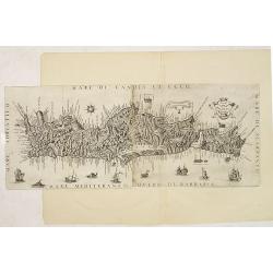
Il Regno Di Candia.
This rare map is based on the important map of Crete by Basilicata. The maps by Marco Boschini reached a wider audience than the few individuals for whom the Basilicata m...
Date: Venice, 1660

Ducatus Limburg.
A very rare issue of this map of Limburg. Cornelis Danckerts II copied the folio map of H.Hondius.The publisher's address was placed in the lower right-hand corner. The c...
Date: Amsterdam, 1636

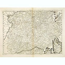
Nouvelle et exacte Carte du Duche de Brabant. . .
A very rare example of a map of the Duchy of Brabant. Title cartouche in the lower left-hand corner. A very rare issue of this map of Brabant. Cornelis Danckerts II. copi...
Date: Amsterdam, 1635
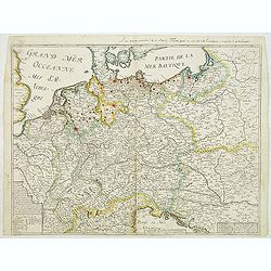
Carte generalle d'allemaigne nouvellement misse en françois et Ampliffiée de tous les Royaumes. . .
Attractive and rare map of Germany, the Low Countries, Austria, Moravia, Switzerland and part of Poland.
Date: Paris, 1632-1660
Ducato di Luxembourgo . . .
A beautiful and flamboyantly engraved map of Luxembourg. The map is the product of the late 17th century Venetian cartographer, Vincenzo Coronelli. A decorative title car...
Date: Venice, 1698
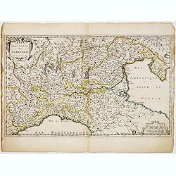
Carte Générale de Lombardie.
Fine map of Northern and middle part of Italy, engraved by A Peyrouin. According to the credit in the cartouche the map has been prepared by Pierre Duval.
Date: Paris, ca. 1650
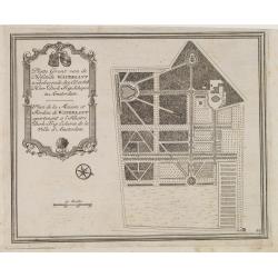
Gemete Kaerte van de Stede Beverwyk, zoo als die tegenwoordigh zich vertoont.
Uncommon plan of Beverwijk made in the year 1739. Published in Hollandsche Arcadia. Title in Dutch and French.
Date: Amsterdam, ca.1740
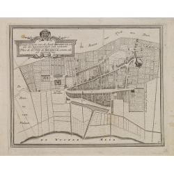
Platte Gront van de Hofstede Waterlant toebehorende den Ed. Achtb. Heer Dirk Trip Schepen te Amsterdam.
Uncommon plan of Hofstede Waterlant. Published in Hollandsche Arcadia. Title in Dutch and French "Plan de la Maison et Jardins appartenant a l'Illustre Dirk Trip Ech...
Date: Amsterdam, 1740

Pianta Della Citta di Roma con la Indicazione di tutte le Antichita e Nuovi Abbelliment.
Beautifully engraved town plan of Rome, featuring side borders that depict the 16 most important monuments, along with a legend that locates the significant places and bu...
Date: Venanzio Monaldini, Rome, 1829
![Sexta Etas Mundi. Constancia. [Constance CCXLI ]](/uploads/cache/33141-250x250.jpg)
Sexta Etas Mundi. Constancia. [Constance CCXLI ]
A very fine town view of Constance, in Germany, centered on the cathedral (198 x 520 mm).VERSO, seven insets of scientists, noblemen and Popes.Page from the richest illus...
Date: Nuremberg, 12 July 1493
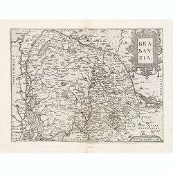
Brabantia.
Map of Brabant from Guicciardini's "Description de touts les Pais-Bais" edited by Plantin in 1582. The map drawn after Ortelius' map of Brabant, and after the l...
Date: Antwerp, 1582
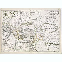
Romani Imperii Oriens est Descriptio Geographica. . .
A fine map of the Near East. The map was first published by Tavernier and later by Mariette. This edition is dated 1637 with the address of Pierre Mariette at rue S. Jacq...
Date: Paris, after 1637

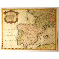
Tabula Secunda Europe (Spain & Portugal)
Wood block printed large-format Ptolemaic map of the Iberian Peninsula from the 1513 edition of Waldseemüller's Geographia.This Ptolemaic map comes from the first so cal...
Date: Strasburg, 1513

Carte von West=Gallizien welche auf allerhöchsten Befehl Seiner Kaiserlich oesterreichischen und Königlich apostolischen Majestät in den Jahren 1801 bis 1804. . .
Important early map of Western Galicia, as given to Austria by the third Partition of Poland (1795). Due to its lengthy development period, a rare map rich in detail depi...
Date: Vienna, (1808) after 1811

Schlavoniae, Croatiae, Carniale.. Bosniae. . .
First state. Fine and early map of former Yugoslavia after a map of Hirschvogel (1552-1565) and used by A.Ortelius in his atlas 'Theatrum Orbis Terrarum [Atlas of the Who...
Date: Antwerp, 1579
![Matelot Hollandais [Dutch sailor]](/uploads/cache/28927-250x250.jpg)
Matelot Hollandais [Dutch sailor]
Etching showing a typical Dutch sailor, after Jacques Grasset de Saint-Sauveur (1757–1810). Taken from "Costumes Civils actuels de tous les peuples connus, dessin�...
Date: Paris, Pavard, 1788

Tabula Episcopatuum Leodiensis et Coloniensis. . .
Rare issue of Cornelis Danckert's attractive map of Limburg, shows the area of Cologne, Mainz, Trier, Jülich, Mons, Antwerp and Liege in Belgium.Decorative title cartouc...
Date: Amsterdam, 1700
![[Set of 6 maps] Charta öfver Storfurstendömet Finland på Friherre S. G. Hermelins Anstalt och Omkostnad. Sammandragen och författad af C. P. Hällström. Philos. Magister och Auscultant i Kongl. BergsColl. 1799.](/uploads/cache/34482-250x250.jpg)
[Set of 6 maps] Charta öfver Storfurstendömet Finland på Friherre S. G. Hermelins Anstalt och Omkostnad. Sammandragen och författad af C. P. Hällström. Philos. Magister och Auscultant i Kongl. BergsColl. 1799.
This is a beautiful set of a key map and five separate maps of Samuel Gustav Hermelin's map of Finland. The maps have been engraved by Fredrik Akrel, a very skilled and p...
Date: Källa: J.Strang & E.- S. Harju: Suomen karttakirja 1799
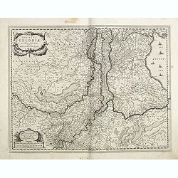
Ducatus Geldriae novissima. . .
Early map of Gelderland, but also including Utrecht, and parts of Brabant. Shows many cities (like Nijmegen, Eindhoven, Zutphen, Zwolle, etc), roads, rivers, woods, regio...
Date: Amsterdam, 1629-1630
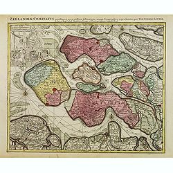
Zeelandiae Comitatus. . .
Scarce map of Zeeland, this is the state published by Tobias Conrad Lotter, previously published by Matthäus Seutter.Impressive cartouche with coat of arms of Zeeland to...
Date: Augsburg, c.1760
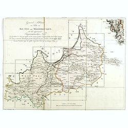
(Index sheet) General Tableau zur Karte von Alt Ost und West Preussen nebst dem aufgenommenen Trigonometrischen Netz. . .
Index sheet of this important multi-sheet map of Prussia, Lithuania, and Poland.Section XXIV of the rare first edition of this important 25-sheet map prepared by Friedric...
Date: Berlin, 1802-1810
(Sheet X with Puk Bay from) General Tableau zur Karte von Alt Ost und West Preussen nebst dem aufgenommenen Trigonometrischen Netz. . .
Sheet IV with Zalew Wislany and the towns of Elblag, Paslek, Braniewo, etc, of this important multi-sheet map of Prussia, Lithuania, and Poland.The rare first edition of ...
Date: Berlin, 1802-1810

Map of Russia and Poland.
Charming, folding map of Russia, Poland and Baltic States, still in its original publisher's blind stamped linen wrapper with yellow label. With yellow advertisements at ...
Date: London, ca. 1894
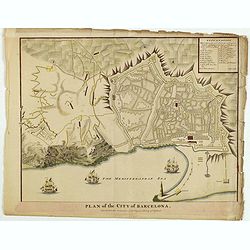
Plan of the City of Barcelona.
From Rapin's History of England , a nicely detailed plan of Barcelona, the capital of Catalonia. The plate contains a 19 point legend and the presentation is enhanced wit...
Date: London, c.1745
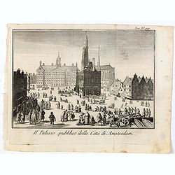
Il Palazzo pubblico della Citta di Amsterdam.
Fine panoramic views of the Dam square in Amsterdam, taken from Storia moderna di tutti I popoli del mondo , edited by Thomas Salmon. A Italian edition of this famous wor...
Date: Venice, 1740-1756

A plat of the East Sea. By William Fisher and Richard Mount...
An important sea chart of the East Sea with coast lines of Poland, Russia, Sweden, published by William Fisher and Richard Mount in London.Richard Mount (1654-1722) was a...
Date: London, 1695
Westphalia Ducatus.
Originally engraved for Jodocus Hondius II, at his death in August 1629 this map was, among 39 other copper plates,purchased by Willem Blaeu who deleted Hondius' name and...
Date: Amsterdam, 1634
Selling price: ????
Please login to see price!
Sold in 2025
A New and Accurate Map of the Kingdoms of Spain, Portugal and Part of France, The Islands of Majorca, Minorca &c.
Produced for “Universal Magazine” by J. Hinton. It was engraved by Richard William Seale (1703-1762). The map features an attractive rococo cartouche and compass ros...
Date: London, ca. 1760

Russia & Poland.
Charming, folding map of Russia and Poland, giving a detailed overview of Europe from Baltic to Caspian Sea. Railways and rivers prominently delineated.In lower left a ke...
Date: London, ca. 1890

Romani Imperii Imago.
Very rare map in a first edition by Jacques Honervogt. Copied after a map by Ortelius but much rarer. The medallion portraits are of Romulus and Remus - the genealogical ...
Date: Paris, 1630
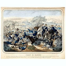
Combat de Palestro.
Showing the battle of Palestro lithographed by E.S. Walter and printed by De Becquet and published by Rousselot in Paris.The lithograph is part of a series of prints publ...
Date: Paris, ca. 1860
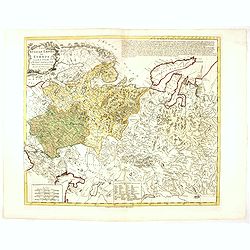
Russian Empire in Europe from the Dr. D'Anville of the Royal Academy. . .
Rare map of Russia, prepared by John Bayly (active 1755-1794) after D'Anville. In the lower-left corner parts of the Caspian and Black Sea. In the upper right corner Nova...
Date: London, ca. 1782
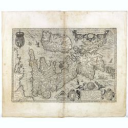
Angliae, Scotiae, et Hiberniae, sive Britannicar : Insularum descriptio.
A rare and ornate map with inset portraits of James First, Henry Prince of Wales Princess Anne of Denmark.Janssonius acquired the copperplate of van den Keere's 1604 Brit...
Date: Amsterdam, 1621

(View of the Moscow Kremlin, seen from the Moskva River in the south).
Anonymous, likely Russian School gouache drawing of Moscow Kremlin. The Kremlin is depicted in a typical 19th century romantic style and is seen from the Moskva river in ...
Date: Russia, ca. 1850

Nouveau théâtre de la guerre entre les Russes les turcs et les polonois confédérés.
A very rare separately published map of Crime region. With a large title cartouche lower left "Nouveau theâtre de la guerre entre les russes, les turcs et les polon...
Date: Paris, 1769
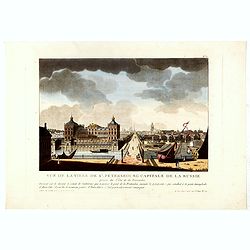
Vue de la ville de St. Pétersbourg capitale de la russie prise du côté de la Fontanka . . .
This aquatint print figures the town of St. Peterburg. With address "A Paris chez le Coeur graveur, rue Mouffetard, N° 89 et chez Bance aîné, rue Saint Denis, N°...
Date: Paris, Le Cœur et Bance ainé, ca 1814

Langley's New Travelling and Commercial Map . . .
A highly desirable, detailed and uncommon map of England and Wales, published by Langley and Belch. The map is flanked by a pair of large and detailed explanation tables,...
Date: London, 1817

Karte der Ukraina.
A large political, economical and transportation map of Ukraine, printed three months after the beginning of the WW II in Ukraine. Shows the newest borders, streets and r...
Date: Vienna: Freytag u. Bernd u. Artaria August 1941

Fossa Sanctae Mariae.
Detailed map of part of the country between rivers Rhine and Meuse showing a canal to be dug between 1626 and 1628 between Rheinberg in Germany and Venlo. A deficiency of...
Date: Amsterdam, 1645
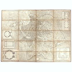
Pianta topografica di Roma moderna estratta dalla grande del Nolli an 1829
Town plan of Rome based on map by Giovanni Battista Nolli, ( fl. 1692-1756). Engraved by Pietro Ruga. With a key (I - XIV), scale and text "Nuova pianta di Roma mode...
Date: Rome, 1829

Deutschlands Postkarte begraenzt von Oesterreich, Preussen, Frankreich, Holland, Italien und der Schweiz. . .
A detailed and crucial post-road map prepared by Ignaz Heymann. The map shows the Low Countries, Germany, Poland, Austria, Hungary, etc.Borders in original outline colo...
Date: Triest, 1800

Gelriae, Cliviae, Finitimorumque Locorum Verissima..
East to the top. Fine map of Geldria and Limburg, prepared by Christian s'Grooten. Very fine title cartouche lower right with painter's utensils around the cartouche. ...
Date: Antwerp, 1598

Hollandiae Antiquorum Catthorum..
This map shows Holland in great detail, including small towns, walled cities, rivers and lakes (many of which were reclaimed in the 17th century, and no longer exist). A ...
Date: Antwerp, 1598

Silesiae typus..
Fine and early map of Silesia after Martin Helwig (1516-1574) and used by A.Ortelius in his atlas 'Theatrum Orbis Terrarum [Atlas of the Whole World].Only included in the...
Date: Antwerp, 1598
Carte de l'Asie Minevre ou de la Natolie et du Pont Euxin...
A map centered on the Black Sea and the geographical regions surrounding it. The map shows Asia Minor, Crete, Cyprus, northern Syria, Iraq, Georgia, Crimea, Bulgaria, Rom...
Date: Nuremberg, 1743
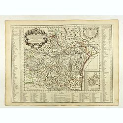
Carte du Diocese de Beziers . . .
Fine map of the diocese of Béziers with the address : A Paris Chez l’Auteur sur le Quai de l’Horloge a l’Aigle d’Or, avec Privil. Pr . 20 ans Mai 1708.In early 1...
Date: Paris, 1708
Carte du Diocese de Narbonne.
Topographically detailed map of the Narbonne diocese in southwestern France. Includes major roads and is supplemented with an extensive index. Inset map plan of the forti...
Date: Paris, 1704
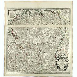
Carte du Brabant.
Map of Brabant with the address : Chez l’Auteur sur le Quai de l’Horloge (address erased after Horloge). Avec privilege du Roy. 1705." Guillaume de l'Isle's (167...
Date: Paris, 1705
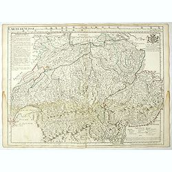
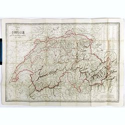
Carte de Suisse ou sont les Cantos de. . .
General map of Switzerland with all the cantons good detail, with the imprint "A Paris Chez l’Auteur sur le Quai de l’Horloge Avec Privilège Aout 1715". In...
Date: Paris, Aout 1715
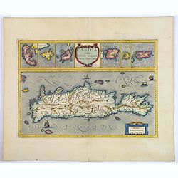
Candia cum Insulis aliquot circa Graeciam.
An attractive (if rather inaccurate) map of Crete, with insets of the islands of Corfu, Zante, Milos, Nicsia, Santorini, and Scarpanto.
Date: Amsterdam, ca 1636
Borussiae Regnum compectens Circulos Sambiensem, Natangiensem, et Hockerlandiae Nee non Borussia Polonica, exhibens Palatinatus Culmiensem. . .
Decorative map covering northern Poland with Prussia, Pomerania, Hockerlandia, Warmiaermelandia, Natanglensis, Galindia, Nandrovia, Sclavonia, and the Baltic Sea. Include...
Date: Augsburg, 1759
Carte de la Suisse . . .
Detailed canvas map of Switzerland.
Date: Paris, 1850
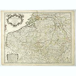
Carte Des Pays Bas Catholiques Dressée. . .
Rare with the address "Chez l’Auteur sur le Quai de l’Horloge a la Cour. ne de Diamans, 1702. Se trouve à Amsterdam chez L. Renard Libraire près de la Bourse.&...
Date: Paris, 1702

Tafel der Lender darin der Apostel Paulus geprediget hat.
Rare wood block map depicting the Mediterranean, with an over-sized Cyprus from the final Dutch edition of Heinrich Bünting's famous Itinerarium Sacrae Scripturae, a boo...
Date: Magdeburg, 1581

Carte du pays de Montenegro dressée d'après les opérations géodétiques . . .
Rare map of Montenegro prepared by Mr. le Comte Fedor de Karacsay (1787-1859) and engraved by Pietro Allodi. The title is in Russian, Arabic and French.In lower left corn...
Date: Vienna, ca. 1838

The hanging of the head of police Jean Grauwels in Brussels, 11 february 1569.
Print relating to Brussels during the first decades of the eighty year war between Spain and the Low Countries: (plate 18). This plate shows the hanging of the head of po...
Date: Cologne, ca. 1590
Antiquae urbis perfecta et Nova delineatio. [ Ancient Rome)
First state before imprint of Jacobus de Rubeis. A rare view of Ancient Rome from the Lafreri-School in the style of Ambrogio Brambilla's view of about 1575. A unique opp...
Date: Rome, ca. 1600

Vue et perspective de la ville de Marseille et ses environs, prise du côté de la belle vue de la plaine St. Michel. Dediée à S. A. S. Mgr. le duc de Penthievre Grand Amiral de France. Par son très humble et très obéissant Serviteur Aulagnier.
Scarce large and spectacular panorama of the city and harbour of Marseille published in Paris in the middle of the 18th century. Engraved by Pierre Jacques Duret under th...
Date: Paris, 1751
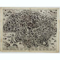
![[View of Gulf of Trieste].](/uploads/cache/45191-250x250.jpg)
[View of Gulf of Trieste].
Very rare view of Gulf of Trieste published in the first edition of "Viaggio da Venetia, a Costantinopoli. Per Mare, e per Terra, & infieme quello di Terra Santa...
Date: Venice, Giacomo Franco, 1598
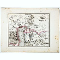
Il Turkestan il Mar d'Aral ed il Mar Caspio.
Uncommon map of Turkestan with the Northern part of the Caspian Sea, with part of present-day Uzbekistan in the lower right corner. in the prepared by Francesco Costant...
Date: Genova, Paolo Rivara fu Giacomo, 1858
Potentissimo Borussorum Regi Friderico Wilhelmo...
Large and sought-after 2-sheet map of an area of Lithuania and Eastern Prussia (Russian province of Kaliningrad) stretching from Klaipeda (Memel) in the north to Goldap i...
Date: Nuremberg, 1735
![Le Roy de Navarra venant à Paris recheut le coup de cousteau au visaige par ung Pierre Chastel, lequel par quatre chevaulx fut tiré en pièces, faict le 27 de Decemb[re] l'an 1594.](/uploads/cache/38548-250x250.jpg)
Le Roy de Navarra venant à Paris recheut le coup de cousteau au visaige par ung Pierre Chastel, lequel par quatre chevaulx fut tiré en pièces, faict le 27 de Decemb[re] l'an 1594.
Engraved news-sheet with text in German and French. Pictorial reportage on the failed assassination attempt on King Henri IV of France by Jean Châtel (here identified as...
Date: Cologne, ca. 1600