Recently Listed Listings in Europe

Polonia regnum et Silesia ducatus.
Very decorative map of Poland embellished with two cartouches and two coats of arms surmounted by cherubs and female figures. Showing the region from the Oder east to Pod...
Date: Amsterdam, 1638

Vue de Malthe du cote du Fort.
A so-called optical print of Valletta seen from the castle. This rare optical print shows people in typical French dresses in the foreground and placed in boats.In the ei...
Date: Paris, 1798

Die Stadt Narva. . .
An early of the town of Narva, located at the eastern tip of Estonia, on the Russian border.From the uncommon Hamburg edition "Viel Vermehrte Moscowitische und Pers...
Date: Hamburg, 1696

Lutzenburgensis Ducatus veriss descript.
Prepared by Jacob Surhon who made a manuscript map of Luxembourg for which he received 500 Livres from Charles V in 1551. For security reasons the map was not published. ...
Date: Antwerp, 1609

Vuë de l'ancien Palais d'hiver de sa Majesté Imperiale et du Canal qui Joint la Moika avec la Neva, a St. Petersburg.
So-called optical print illustrating a perspective view of St. Petersburg, namely the ancient Winter Palace and the canal which joins the Moika to the Neva.In the eightee...
Date: Paris, 1760

Carinthiae et Goritiae... / Histria tabula.../ Zarae, et Serebenici ..
Three maps on one sheet. The left hand is centered on the eastern part of Austria. The right upper hand map is centered on northern Yugoslavia, and the last map is center...
Date: Antwerp, 1598

III. Carte de la Hollande.. Over-Yssel.
Attractive small map centered on the delta of the River Ijssel, where it discharges into the Zuiderzee.From Atlas Portatif Universel, by Robert de Vaugondy. Unrecorded st...
Date: Paris, later than 1748

VI. Partie du Duche de Gueldre où se trouve la Veluwe.
Attractive small map covering the northwestern part of Gelderland. In the center "'t Loo". From Atlas Portatif Universel, by Robert de Vaugondy.Unrecorded state...
Date: Paris, later than 1748

Royaume de Bohéme, Marquisat de Moravie, et Silésie Autrichenne.
Small detailed map of today Czech Republic. From Atlas Portatif Universel, by Robert de Vaugondy.Unrecorded state with erased date. Page 32 outside border top right. Mary...
Date: Paris, later than 1749

Pianta Geografia delle Isole di Malta, e Gozo della Sagra Religione Gerosolimitana di S. Giovanni delineata, ed incisa in quest anno 1761.
A rare map of Malta and Gozo printed by the priest Antonio Bova (1688 - 1775), who was active as engraver in Palermo ca. 1727-1773. He produced cartographic engravings, s...
Date: Bova Ant., Palermo, 1761

Nova Helvetiae Tabula.
A most decorative "carte à figures" map with panoramic views of Lucern, S.Gal, Bern, Solothurn, Schafhausen in upper border and Basel and Zurich in lower left ...
Date: Amsterdam, 1630

De Haven en Straat von Gibraltar, Niewlyks getekend, en in`t licht gebracht door Johannes Covens en Cornelis Mortier tot Amsterdam.
Decorative map showing the siege of Gibraltar during the Spanish war of succession. This highly interesting map is richly ornated with three additional inset maps and vie...
Date: Amsterdam, 1710

La mer Mediterranee divisee en ses principales parties ou mers. . .
Very large map centered on the Mediterranean. With a sub title along upper margin "La Mer Mediterranée divisée en Mer de Levant et de Ponant Subdivisées en Leurs ...
Date: Amsterdam, c.1705

Europa, ad magnae Europae Gerardi Mercatoris. . .
General map of Europe, as well as Americae Pars, Greenland, Iceland, a Polar landmass, along with the mythical islands of Frisland, Drogeo, and Bradain. A large strapwor...
Date: Amsterdam, 1628

Portugalliae que olim Lusitania..
The best-known map of Portugal, after Alvares Secco (1560), orientated west to the top of the sheet. Secco's map was copied by many mapmakers and publishers for upwards o...
Date: Amsterdam, 1628

Carte des Isles de Maiorque Minorque et Yvice dediée A.M. le Comte de Maurepas Ministre et secretaire d'Etat. . .
Fine map of the Baleares with much detail, in lower part inset "Plan du Port de Mahon du Fort St. Philippe et ses Fortifications". The map is dedicated to Jean ...
Date: Amsterdam, after 1740

Henna ardera deel. De vijfde Grietenije van de Wester goo. . .
Very detailed map of "Henna ardera deel. De vijfde Grietenije van de Wester goo" in Friesland prepared by Bernardus Schotanus Steringa. With decorative title ca...
Date: Leeuwarden, 1718
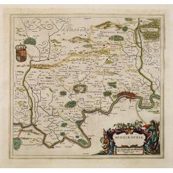
Middle-sexia.
Double-page map of the old Middlesex County, including a marvelous depiction of London on the Thames in the lower right corner. Decorative cartouche and coat of arms. Lat...
Date: Amsterdam, 1662
Selling price: ????
Please login to see price!
Sold in 2024

Carte de la Manche. . .
Decorative chart showing the Chanel, with the coastline of France from La Baie de Douarnenez to Dunkerque, and the coastline of England from Stroble head to Manning Tree....
Date: Amsterdam, 1692

Saint Petersbourg. Maison de bienfaisance, appartenant à Mr Anatole de Demidoff. . .
Beautiful lithography showing the house of Anatole de Demidoff in Saint Petersburg.
Date: Paris, c. 1850
![Tabula electoratus Brandenburgici, Meckelenburgi, et maximae partis Pomeraniae, ex variis, famosissimisq[ue] auctoribus summo studio concinnata. . .](/uploads/cache/29543-250x250.jpg)
Tabula electoratus Brandenburgici, Meckelenburgi, et maximae partis Pomeraniae, ex variis, famosissimisq[ue] auctoribus summo studio concinnata. . .
Uncommon "carte à figures"- map engraved by the master engraver Abraham Goos and published by Claes Jansz. Visscher (1587-1652). Showing the area of Brandenbur...
Date: Amsterdam, 1630
![Basilae [ Basle, CCXLIIII ]](/uploads/cache/29714-250x250.jpg)
Basilae [ Basle, CCXLIIII ]
A very fine view of Basle (253x520 cm). Verso showing the councils of Florence and Basle and two portraits.Page from the richest illustrated Incunabel, the famous: Nuremb...
Date: Nuremberg, 12 July 1493

Paskaert vande Bocht van Vranckrijck Biscajen. . .
An eye-catching chart of the coast of Bretagne from Brest running south till the coast of Biscay in Northern Spain.Including the towns of Ferrol in the west, Gijon, Santa...
Date: Amsterdam, after 1666

Imperium Russicum, cum regionibus adiacentibus duabus Tabulis ex optima quae A. 1784 tribus foliis comparavit Mappa geographica, aliisque subsidiis delineatum a C. Mannert, Tabula Ima. . .
A detailed map of the European part of the Russian Empire. Scarce map. Copper etching by C. Mannert and edited by Adam Gottlieb Schneider and Johann Christoph Weigel. Man...
Date: Nuremberg, 1794

Valletta ou Valete ville Forte, de l'Isle de Malta.
A beautifully engraved and richly detailed birds-eye plan of the harbour and city of Valletta seen from the northwest. In lower part extensive key, identifying 57 feautur...
Date: Amsterdam, 1705

Plan de la ville de Malthe ses Forts, ses Nouvelles Fortiffications. . .
Detailed plan of Valletta. In upper right corner a key (A-Z & 1-32) to the principal places in town. Prepared by N.de Fer and re-issued by Danet.
Date: Paris, 1723
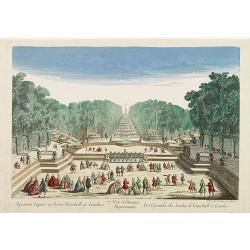
77e Vüe d'Optique Représentant Les Cascades du Jardin de Vauxhall a Londres.
So-called optical print illustrating a perspective view of the fountains and artificial cascades in Vauxhall Gardens, London.In the eighteenth and nineteenth centuries th...
Date: Paris, 1760

Nieuwe kaart van het Koningrijk der Nederlanden. . .
Uncommon map of the Netherlands prepared by J.S. Smulders and P. H. Witkamp and lithographed by Z.M. den Koning in the Hague. Dated.Showing The Kingdom of the Netherlands...
Date: The Hague, 1874

.Paskaart van de Mont van de Witte Zee,. Beginnende van Tiepena tot Pelitza, als mede van C. Cindenoes tot Catsnoes.
Fine sea chart of the southern part of the Barents Sea, oriented to the West. With five inset maps: - Swetenoes, de Kust van Laplandt, Lombascho, 'T Vaste Landt van Lapla...
Date: Amsterdam, c.1710

Potentissimo Borussorum Regi Friderico Wilhelmo Maiestate, Fortitudine Clementia Augustissimo Hancce Lithuaniam Borussicam : in qua luca coloniis Salisburg., ad incolendum Regio nutu...
Potentissimo Borussorum Regi Friderico Wilhelmo Maiestate, Fortitudine Clementia Augustissimo Hancce Lithuaniam Borussicam : in qua luca coloniis Salisburg., ad incolendu...
Date: Nuremberg, 1735
![.[Balkan region with Austria, Croatia, Slovenia, Switzerland, etc]](/uploads/cache/33858-250x250.jpg)
.[Balkan region with Austria, Croatia, Slovenia, Switzerland, etc]
Wood block printed map and one of earliest printed representation of Balkan with Austria, Croatia, Slovenia, Switzerland, etc prepared Martin Waldseemüller. Based on the...
Date: Vienna, 1525 -1541

Vue Interieure de la Bourse Royale à Londres.
So-called optical print of the London stock exchange. Daumont was a well-known publisher of optical prints, established in Paris. In the eighteenth and nineteenth centuri...
Date: Paris, 1760

Dongerdeel.. De vierde grietenij van Ooster Goo.
Very decorative map centered on Dokkum, Metzerwier, and Pasens from the Uitbeelding der Heerlijkheit Friesland prepared by Schotanus. With decorative title cartouche lowe...
Date: Leeuwarden, F.Halma, 1718

De zee cuften tufschen Dovere en Orfords nesse, daer de Teemse de Vermaerde Rivire van Lonen gelegens is. . .
A detailed chart of the English Channel coastland. Decorated by a colorful title cartouche and scale cartouche, one compass rose, several vessels and sea monsters. A very...
Date: Leiden, Plantijn, 1585

Belchrijuinghe vande zee custen van Engelandt. . .
A rare Dutch text edition of this detailed early chart of the northern coast of England. West to the top. The mileage cartouche has no Latin captures. Decorated by a colo...
Date: Leiden, Plantijn, 1585

Zee caerte vande Sondt tvermaerste van Danemarcke . . .
A detailed chart of the coast of Denmark and its islands, Copenhagen in the center of the chart. West to the top. It is decorated by a title, scale and descriptive cartou...
Date: Leiden, Plantijn, 1585
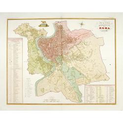
Pianta della citta di Roma.
Published in "Atlante Geografico dell' Italia". Uncommon and decorative town-plan of Rome. With a numbered key. Engraved by P.Manzoni.
Date: Florence, 1845

6e Vüe d'Optique Représentant Le Chœur de la Cathedrale de St. Paul de Londres.
So-called optical print illustrating a perspective view of the interior of the Saint Paul Cathedral in London.In the eighteenth and nineteenth centuries there were many p...
Date: Paris, 1760

5e Vue d'Optique Representant La Vue interieure de la Cathedralle de St. Paul de Londres.
So-called optical print illustrating a perspective view of the interior of the Saint Paul cathedral in London. Engraved by la Marcade.In the eighteenth and nineteenth cen...
Date: Paris, 1760

26e Vüe d'Optique Representant L'Abbaye de Westminster et de l'Eglise Ste. Marguerite à Londres.
So-called optical print illustrating a perspective view of the Westminster Abbey, in London.In the eighteenth and nineteenth centuries there were many popular speciality ...
Date: Paris, 1760

A View of S. James's Palace Pall Mall. - Vues du Palais royal de S.Jacques Pall Mall.
So-called optical print illustrating a perspective view of St James's Palace, Pall Mall. The gatehouse of St James's Palace is on the left.In the eighteenth and nineteent...
Date: Paris, 1753

Vüe Perspective du Pont neuf construit sur la tamise a Hampton-Court.
So-called optical print illustrating a bridge on the river Thames at Hampton-Court.In the eighteenth and nineteenth centuries there were many popular speciality establish...
Date: Paris, 1760

La Pologne Dressée sur ce qu'en ot donné Starovolsk, Beauplan, Hartnoch. . .
Large map of Poland, Lithuania, Belarus and part of Ukraine. The map is filled with detail and decorated with a title cartouche flanked by mythological figures.According ...
Date: Paris, 1773 - 1780

Tableau des guerres de Frédéric le Grand: ou plans figurés de vingt-six batailles rangées, ou combats essentiels donnés dans les trois guerres de Silésie. . .
The book includes a large folded map "Tableaux des Guerres de Frédéric le Grand", showing a map of Prussia, with present-day Poland and Eastern Germany surrou...
Date: Potzdam, Strasbourg, Paris, 1788

Nova et accurata Tabula Hispaniae. . .
Second state. The map shows the geographical image introduced by Hessel Gerritsz's 1612 wall map of Spain, based on information provided by the Coimbra University profess...
Date: Amsterdam, 1633

Dominio Veneto nell' Italia.
With the Gulf of Venice. Including the towns of Cremona, Brescia, Venice, etc.As Willem Blaeu died in 1638 most of his maps are actually published by his son Joan. This m...
Date: Amsterdam, 1638

Carte particuliere d'une grande partie des estats situez sur le haut rhein et sur les rivieres qui si déchargent comme sont L'Alsace, la Souabe et la Lorraine,&c. . .
Detailed map of Alsace, Lorraine and Souabe, centered on the River Rhine.
Date: Paris, 1705
Salzbourg.
Uncommon and decorative lithography published by Carl Johan Billmark and printed by Lemercier in Paris, 55 rue de Seine, the leading firm in Europe at that time. From: It...
Date: Paris, c.1859

Launa vulgo Laun Bohemiae civitas.
Bird's-eye views of Louny in Bohemia by G. Hoefnagel. The copperplate was made for Braun and Hogenberg's town book. However there the print has been transformed by the en...
Date: The Hague, 1700

Tschopau.
Very decorative and rare panoramic of Tschopau.The engraver and publisher of prints, Mrs. Anna Beek of the Hague, enlarged the print and mounted it on larger paper: she ...
Date: The Hague, ca. 1700

Volna.
Very decorative and rare panoramic town-view of Volna. We have more Anna Beek prints available.The engraver and publisher of prints, Mrs. Anna Beek of the Hague, enlarg...
Date: The Hague, ca. 1700

Strasborcs In der Vocker Marckt.
Very decorative and rare panoramic town view of Völckermarckt in Kärten.The engraver and publisher of prints, Mrs. Anna Beek of the Hague, enlarged the print and mounte...
Date: The Hague, ca. 1642

Statt Talbe an der Saal.
Very decorative and rare panoramic town view of Calbe a.d. Saale, Bez Magdeburg.The engraver and publisher of prints, Mrs. Anna Beek of the Hague, enlarged the print and ...
Date: The Hague, ca. 1642

Czaslaw.
Very decorative and rare panoramic of Czaslaw, Caslav, Tschslau in Böhmen.The engraver and publisher of prints, Mrs. Anna Beek of the Hague, enlarged the print and moun...
Date: The Hague, ca. 1642

Wittstocs.
Very decorative and rare panoramic of Wittstock, Bez. Potsdam.The engraver and publisher of prints, Mrs. Anna Beek of the Hague, enlarged the print and mounted it on larg...
Date: The Hague, ca. 1642

Leisnig.
Very decorative and rare panoramic town view of Leisnig a.d. Freiberger Mulde.The engraver and publisher of prints, Mrs. Anna Beek of the Hague, enlarged the print and m...
Date: The Hague, ca. 1642

ANTIBES, Ville et Port de Mer de Provence, sur la Mer Mediterranée.
Early plan of Antibes. From his "Introduction à la fortification".
Date: Paris, 1693

St Tropez.
Early plan of St.Tropez. From his "Introduction à la fortification".
Date: Paris, 1693

Kollumer land En het Nieuw Kruys land de vijfde gritenije van Oostergoo . . .
Very detailed map of "Kollumer land En het Nieuw Kruys land de vijfde gritenije van Oostergoo" in Friesland prepared by Bernardus Schotanus Steringa. Centered o...
Date: Leeuwarden, F. Halma, 1718

Comitatus Zutphania.
A very detailed map of this area, including Arnhem, Nijmegen, Zutphen, Groenlo, etc. First imprint, from a Latin edition of the scarce Atlas Appendix.
Date: Amsterdam, 1637

Grande Pologne et Prusse avec les frontières de la Misnie, Lusace, Moravie et Lithuanie.
Detailed map of Poland and Prussia. Published by Pieter van der Aa who published a.o. "Naauwkeurge versameling der gedenkwaardigste zee- en land-reysen", a seri...
Date: Leiden, 1729

Landgraviatus Alsatiae tam superioris..
Alsace, in the far north-eastern corner of France, stands out from other French wine regions thanks to its strong Franco-Germanic influences. Alsace is the only French wi...
Date: Nurenberg, 1710
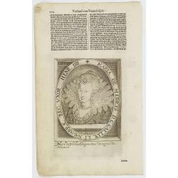
Maria De Medices D. G Galliae et Navarrae Reg. Uxor Henr. IIII.
The engraving depicts a half length oval portrait of Marie de' Medici, queen consort of France .Nicolaes de Clerck (de Klerc) was active as engraver and publisher in Delf...
Date: Amsterdam, Cloppenburch, 1621

Citta, porto, e rada di Brest, e . . . Nella Bretagna . . .
A beautiful and rare map of Bretagne. In top right an inset with the town of Brest.The remarkable Vincenzo Coronelli (1650-1718), encyclopaedist, geographer, inventor and...
Date: Venice, 1690

Languedoc - Foix Roussillon.
Very decorative, informative map of Languedoc - Foix Roussillon region in south eastern France. Including the towns of Carcassonne, Montpellier, Albi, Toulouse, etc.The m...
Date: France, 1943

Guyenne - Gascogne.
Very decorative, informative map of Guyenne and Gascogne region in France. The map is filled with buildings, animals, figures and two locals. With a large compass rose in...
Date: France, 1943

Le Duché d'Aiguillon Tracé Par le Sr. Du Vall.
Home of the "Cahors” This AOC is the most famous of the sub-regions and home to the popular variety Malbec. These inky wines have been adored for centuries, especi...
Date: Amsterdam, 1650

Isola d'Oleron, nella piaggie occidentali della Francia.
A beautiful and rare map showing île d'Oleron.The remarkable Vincenzo Coronelli (1650-1718), encyclopaedist, geographer, inventor and Doctor of Theology, was citizen of ...
Date: Venice, 1690

Het Canaal tusschen Engeland en Vranciick.
An eye-catching chart of the Channel.Pieter Goos (ca. 1616-1675) was one of the most important cartographers, engravers, publishers and print sellers of Amsterdam. His wi...
Date: Amsterdam, after 1666

Forteresse Ile Ste Marguerite.
Nice drawing of a stronghold Ste Marguerite. The Île Sainte-Marguerite is the largest of the Lérins Islands, about half a mile off shore from the French Riviera town of...
Date: France, Provence, after 1960
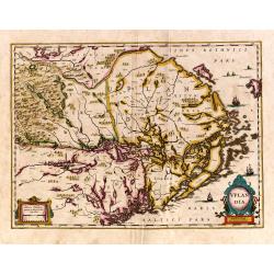
Uplandia.
Covers the area of the modern Uppsala, the vicinity of Stockholm, and includes most of Aland.
Date: Amsterdam, 1639

Moscovia urbs Metropolis totius Russiae Albae.
Detailed bird's-eye town-plan of Moscow from Janssonius' rare townbook. With a key (1-20) to important spots in town. The verso has French text and originates from Jansso...
Date: Amsterdam, 1657

Nostre Dame de Lorette.
A very RARE panoramic of Lorette and the church, including a numbered legend in both lower corners.The plate is numbered in black pencil in upper right corner.Published ...
Date: Paris c.1720

Tabula Ducatus Brabantiae.
Detailed map orientated west to the top.
Date: Amsterdam, 1680
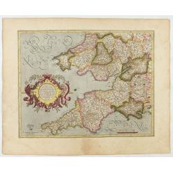
Cornubia, Devonia, Somersetus, . . .
A very nice map showing the south-western part of England. Mercator was born in Rupelmonde in Flanders and studied in Louvain under Gemma Frisius, Dutch writer, astronome...
Date: Amsterdam, 1630
Selling price: ????
Please login to see price!
Sold in 2025

Veue de la Ville, et du Port de Calais, di côte de la terre.
Showing the town of Calais; landscape with, in the left foreground, group of cavalrymen led by an officer and going to right, at right two soldiers walking alongside a ca...
Date: Paris, ca. 1680

s'Lants Zee-Magazyn en Scheeps Timmer-werf.
Decorative view of the back yard of the formerly the V.O.C. warehouse and arsenal for the Admiralty of Amsterdam, now-a-days the Scheepvaartmuseum (Maritime Museum).The p...
Date: Amsterdam, 1694

Gezicht van het Admiraliteits-Magazyn en Scheeps Timmerwerf.
Formerly the V.O.C. warehouse and arsenal for the Admiralty of Amsterdam, now-a-days the Scheepvaartmuseum (Maritime Museum). Taken from the "Atlas of Amsterdam"...
Date: Amsterdam, 1780

A Perspective View of the Admiralty Office, Dock-Yard, Storehouses &c. at Amsterdam.
Decorative engraving giving good detail of the intense activity in the Amsterdam dockyards.Engraved for BANKES's New System of Geography
Date: Amsterdam, 1780

Vue du Magazin de la Compagnie des Indes Orientales. . .
So-called optical print of the formerly the V.O.C. warehouse and arsenal for the Admiralty of Amsterdam, now-a-days the Scheepvaartmuseum (Maritime Museum).In the eightee...
Date: France, 1780