Browse Listings
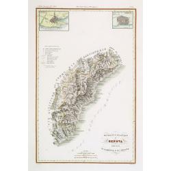
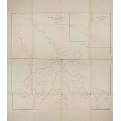
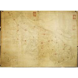
Divisione Militare di Genova. Albenga / Savona.
Very finely engraved and detailed map covering the Mediterranean coast from Oneglia, Albenga, Noli until Savona. Upper corners, two inset plans of Savona and Albenga. Key...
- $250 / ≈ €216
Date: Rome, 1860
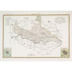
Governo di Milano / Provincia di Mantova e Cremona.
Very finely engraved and detailed map centered on Mantua, including Cremona. Lower corners two inset plans of Mantua and Cremona. Upper left corner, a key. Engraved by Ve...
- $250 / ≈ €216
Date: Rome, 1860

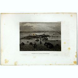
L'escadre alliée bombarde les forts extérieurs de Sébastopol. (18 octobre 1854)
Beautiful Crimean War lithography by Becquet after a painting by Louis Le Breton. The print illustrates the ships "Fort Constantin", "la ville de Paris&quo...
Date: Paris, 1860
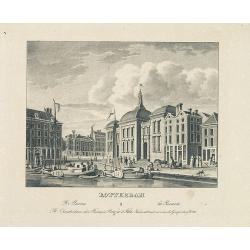
ROTTERDAM De beurs - La Bourse.
Decorative view of the exchange of Rotterdam. Printed by the master printer François Buffa of Amsterdam.
- $75 / ≈ €65
Date: Amsterdam, 1860
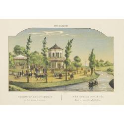
ROTTERDAM Gezigt op de Societeit in het nieuwe. . .
Decorative view of the society of Rotterdam. Decorated with personages in typical dress watching a concert.
- $75 / ≈ €65
Date: Amsterdam, 1860
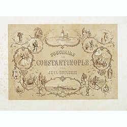
(Title page) Souvenirs de Constantinople . . .
Title page from the famous work "Souvenirs de Constantinople" drawn and lithographed by Jean Brindesi. Surrounded by locals in typical dress, and "Maiden's...
- $100 / ≈ €87
Date: Paris, Lemercier, 1855-1860
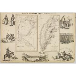
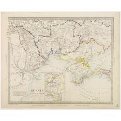
Portions of the Russian Empire in eastern & western Asia.
Two maps on one sheet. Components: The Aral Sea according to Khanikoff -- Kamchatka according to A. Erman. Relief is shown by hachures and spot heights. No. 8 from Fullar...
- $200 / ≈ €173
Date: London, 1860
BATAVIA. Het post etablissement te Weltevreden. L'établissement des postes à Weltevreden.
Rare lithographed view of the post office at Weltevreden (Jakarta). Beautiful lithography drawn by Charles Th. Deeleman (1823 - 1884), lithographed by G.J. Bos and printe...
Date: Batavia, 1859-1860
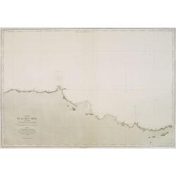
Carte de la Mer Noire. (5e Feuille). Du Cap Zefiros au Cap Kerempeh. . .
Very detailed chart of the Turkish part of the Black Sea including the towns of Sinop, Samsun, etc. Showing soundings in meters, lighthouses are marked with yellow and re...
Date: Paris, 1860
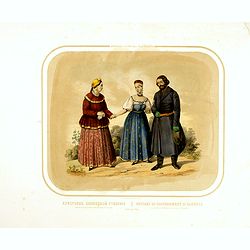
Race Finnoise. Paysans du gouvernement d'Olonetz districts de Petrozavodsk et de Vytiagorsk.
Lithography on tinted grounds printed by Lemercier in Paris and published by Velten in St. Petersburg.
- $100 / ≈ €87
Date: Paris, St. Petersburg, Carlsruhe, c.1860
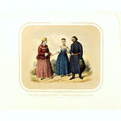
Race Finnoise. = Paysans du gouvernement d'Olonetz districts de Petrozavodsk et de Vytiagorsk.
People in local dress from Petrozavodsk region in Russia. Lithography on tinted grounds printed by Lemercier in Paris and published by Velten in St. Petersburg.
- $150 / ≈ €130
Date: Paris, St. Petersburg, Carlsruhe, c.1860
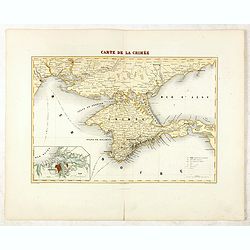
Carte de la Crimée / dressée par A. Vuillemin.
Attractive map of Crimea with inset plan of Sevastopol, prepared by Alexandre Aimé Vuillemin (1812-1886). A road system and the ferry lines are drawn in.Engraved by Jaco...
- $300 / ≈ €260
Date: Paris, ca. 1860
Asia Centrale, Tibet Thian - Scian - Nan - Lu, Mongolia Grand Deserto &.
From the "Geografia Commerciale". Steel engraving with attractive original outline color, printed on thick paper with wide margins. Engraved by C. Magrini.
Date: Genova, 1860
Kronstadt, in der ferne Petersburg.
Bird's eye view of Kronstadt, Russia's naval basis in front of Saint Petersburg. Original steel engraving published by Bibliographisches Institut Hildburghausen.
- $15 / ≈ €13
Date: Hildburghausen, ca. 1860
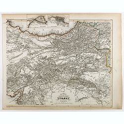
Specialkarte der Asiatischen Turkey : 1. Blatt Anadoli (Klein - Asien)
Steel engraved map of western part of Turkey, engraved by Ifslieb and J. Grassl.
- $75 / ≈ €65
Date: Hildburghausen, 1860
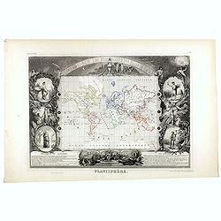
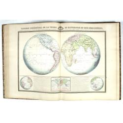
Planisphère.
One of the last decorative maps of the area. In side panels representations of the four seasons. In original out line color, from his "Atlas Universel Illustré"...
Date: Paris, 1845-1860
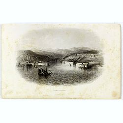
Sebastopol.
Steel engraving of the harbour at Sebastopol in the Ukraine published by James Virtue around 1860.
- $45 / ≈ €39
Date: London, 1860

Frefser.
Etching by Jos Ströber after a design of Loder.
- $75 / ≈ €65
Date: Germany, ca. 1860
Plan de la rivierè de Saigon et de ses affluents dressé par ordre de M. le capitaine de vaisseau d'Ariès, gouverneur de Saigon, d'après les documents fournis par MM. Lespès. . .
A huge folded map the Saigon river prepared after Léo de Lespès, Rieunier Narac. Inset map of "Carte de Banc de Corail, levée d' après les ordres de Mr. le Capta...
- $750 / ≈ €649
Date: St Joseph, Saigon, after 1860
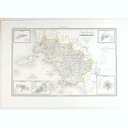
V. Compartimento Grossetano. . .
Very finely engraved and detailed map of Tuscany, centered on Grosseto. The island of Elba in left part.. In the corners insets of Sovana, Massa, Piombino, Orbetello and ...
- $200 / ≈ €173
Date: Rome, 1860
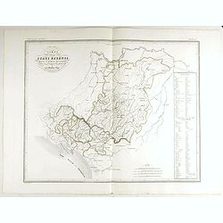
Carta degla Stati Estensi avanti il domino dei Romani Sotto Il governo dei Medesimi.
Very finely engraved and detailed map of the Duchy of Lucca before the dominion of the Romans under the rule of the same and in the Middle AgesWith a key on the right par...
- $200 / ≈ €173
Date: Rome, 1860

Very well . . . mon petite necessaire de voyage . . . very well.
A delightful water color of a portly, jolly looking fellow with braces and a blue checked jacket, settling down to a long journey. He is addressing his remarks to his ess...
- $100 / ≈ €87
Date: Paris, 1860
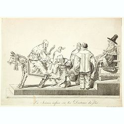
La Science infuse, ou les Docteurs du jour.
Demonstrating the innate knowledge of science, a man is sitting backwards on a donkey holding its tail in one hand and a candle in the other, another man is about to admi...
Date: Paris, 1860

Musicien de la Chapelle. Mr. Lebeau premier trombone du Roi.
A humorous cartoon showing a rather surprised looking Mr. Lebeau - the portly, premier trombone player to the French king, 'playing' a clyster, with tube in mouth, and on...
Date: Paris, ca 1860

Europish Turkije, Griekenland Jonische Eilander.
Uncommon map of Greece, Lithography by J.H. van Weijer, published in Atlas der geheele Aarde in 24 kaarten. With colored key to processions.
- $10 / ≈ €9
Date: Groningen, ca. 1860
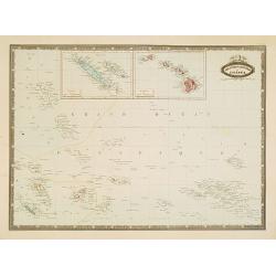
Les divers archipels de L'Oceanie.
Very detailed map from Atlas Sphéroïdal & Universel de geographie , Prepared by F.A.Garnier and edited by Jules Renouard, rue de Tournon, Paris. Uncommon map with d...
- $150 / ≈ €130
Date: Paris, 1861
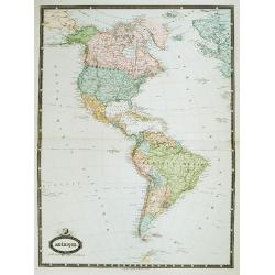
Amérique. . .
Very detailed map from Atlas Sphérodidal & Universel de géographie , Prepared by F.A.Garnier and edited by Jules Renouard, rue de Tournon, Paris. With decorative ti...
- $300 / ≈ €260
Date: Paris, 1861
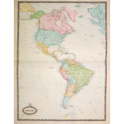
Amérique..
Very detailed map from Atlas Sphéroïdal & Universel de géographie. Prepared by F.A.Garnier and edited by Jules Renouard, rue de Tournon, Paris. With decorative tit...
- $175 / ≈ €151
Date: Paris, 1861
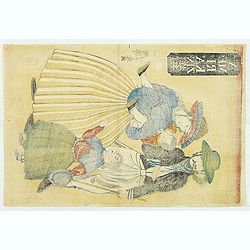
![Gaikoku jinbutsu - Amerika, Furansu. [People from foreign lands - Americans, French ]](/uploads/cache/32196-250x250.jpg)
Gaikoku jinbutsu - Amerika, Furansu. [People from foreign lands - Americans, French ]
Yokohama wood block print showing two women talking with each other. To the right two men in military uniforms. Utagawa, Yoshitora, was a Japanese wood cut engraver activ...
- $1500 / ≈ €1298
Date: Yokohama, 1861
Amerikajin yūkiō. (AMERIKAZIN??) (American family with children)
Wood block print by Utagawa Yoshifuji (1828-1887) of American parents with two children. Edited by Aito and signed : Ipposai Yoshifuji ga.
- $1500 / ≈ €1298
Date: Yokohama, February, 1861
Yokohama Shokan Furansujin umanori no zu. (Picture of a French lady on horse of a trading company in Yokohama)
A Frenchman and a French lady from the Trading Company in Yokohama, design by Utagawa Sadahide (1807-1873) and published by Daikokuya Heikichi and engraved by Hori Take....
- $1350 / ≈ €1168
Date: Yokohama, ca. 1861
![[Ships at sea]](/uploads/cache/08213-250x250.jpg)
[Ships at sea]
Attractive lithography showing Dutch vessels off the Dutch coast, by F.H.Weissenbruch after a painting by L.Meijer. Published in Kunst Kroniek .
Date: The Hague, 1862
![Red Sea - Strait of Jubal.. [2838]](/uploads/cache/23496-250x250.jpg)
Red Sea - Strait of Jubal.. [2838]
Large chart focused on the Strait of Jubal in the Gulf of Suez. With the Juzur Tawilah Islands at the center and an inset plan of the Tur Harbour (At Tur, South Sinai) o...
- $500 / ≈ €433
Date: London (1853) corrected for 1862
Militairy manuscript map of the end of Yangzi River across Shanghai, Jiangsu, and Zhejiang areas, with 3 red seals of the Ever-Victorious Army.
In the lower left corner, an inset plan of Songjiang District with Shanghai is shown with a grid, and the area is divided with red dotted border lines.The map has three r...
Date: China, ca 1862
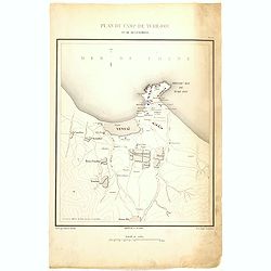
Plan de Camp de Tché-Fou et de ses environs.
A rare and detailed plan of Chefoo, which was a treaty port in Shantung province, near today's Yantai. Plate IV from "Atlas de l'expédition de Chine en 1860: rédig...
- $300 / ≈ €260
Date: Paris, 1862
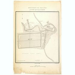
Occupation de Tien-Tsin par la Flottille Anglo-Française le 26 Mai 1859.
Plate III from "Atlas de l'expédition de Chine en 1860: rédigé au dépôt de la guerre d'après les documents officiels, étant directeur le général Blondel, so...
- $250 / ≈ €216
Date: Paris, 1862
![[Lady with a basket.]](/uploads/cache/37928-250x250.jpg)
[Lady with a basket.]
Lithography by Felix after a painting by Isaac Israel. Printed by J.D. Steurwald.
Date: The Hague, Amsterdam, 1862
Carte de l'Asie orientale comprenant l'empire chinois le Japon les états de l'Indo-Chine et le grand archipel d'Asie ou Malaisie.
Detailed map of Malaysia, Thailand, China, Taiwan, and good detail in Philippines. Lower part of a 2-sheet map.
Date: Paris, 1862
Atlas Sphéroïdal et Universel de Géographie. Dressé à l'aide des documents officiels, récemment publiés en France et à l'étranger.
World atlas divided in 6 sections : World and spheres, Europe, Asia, Africa, America and Oceania, Illustrated with 63 maps in original colors, 22 double-page maps and 41 ...
Date: Paris, Veuve Jules Renouard, 1862
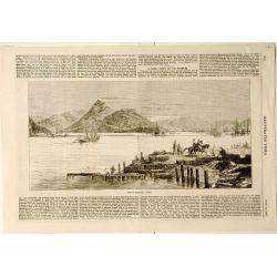
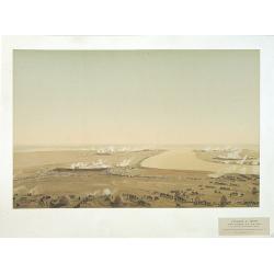
View of Nagasaki, Japan.
A panoramic view of Nagasaki harbour from the Illustrated Times of November 28th., 1863. With accompanying one column descriptive text on verso of Nagasaki.
- $100 / ≈ €87
Date: London, 1863
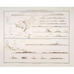
Küstenansichten von Japan bis Capstadt und St. Helena in 5 Blättern.
Prepared by Officer S.M.S. Arcona during the German expedition of 1860-1861 to South East Asia. Lithographed by Lippold and printed by C.Ulrich of Berlin. Sheet 2 from a ...
Date: Berlin, 1863

Great Elephant Imported from Central India.
This is a piece belonging to Misemono-e of animals (literally, pictures of show animals). The giant elephant brought in from India in 1863 was accepted by Japanese people...
- $3000 / ≈ €2596
Date: Yokohama, 1863
![[Macaire] Exploitation de l'amitié. Mon cher Alphonse... (Plate 58)](/uploads/cache/17387-250x250.jpg)
[Macaire] Exploitation de l'amitié. Mon cher Alphonse... (Plate 58)
Macaire personified the clever businessman, who was willing at any time to throw moral and ethical principles overboard for a quick buck. His personality fitted exactly t...
- $175 / ≈ €151
Date: Paris, 1864
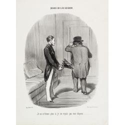
Quand on a du guignon. Je ne m'étonne plus si jevoyais pasmon chapeau . . .
Published by Bauger, rue du Croissant 16 (lower left). Printed by d'Aubert & Cie at Aubert, Place de la Bourse, Paris Text written by Alphonse Jean LAURENT-JAN (1808...
- $250 / ≈ €216
Date: Paris, 1864
Russia in Europe Part VIII with index map.
Very detailed steel engraved map of the region north of the Black Sea, Podolia, Bessarabia, Kherson, Iekaterinoslav, Taurida, Krimea. Relief shown by hachures.The map is ...
- $150 / ≈ €130
Date: London, Edward Stanford, 1864
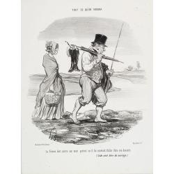
Tout ce qu'on voudra. La femme doit suivre son mari...
TOUT CE QU'ON VOUDRA. (As you like it). This series consists of 94 lithographs published between March 28,1847 and November 30, 1852 in the Charivari. Some of the plates ...
- $360 / ≈ €312
Date: Paris, 1864
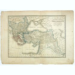
Az Europai és Asiai Torok Birodalom Kozonséges Foldképe
Hungarian map of Turkey, including Greece, Cyprus, etc.
- $150 / ≈ €130
Date: Pesten, 1864
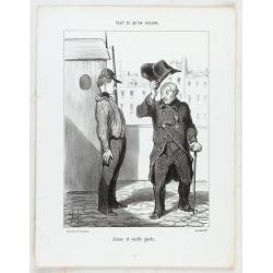
Tout ce qu'on voudra. Jeune et vieille garde...
TOUT CE QU'ON VOUDRA. (As you like it). This series consists of 94 lithographs published between March 28, 1847 and November 30, 1852 in the Charivari. Some of the plates...
- $150 / ≈ €130
Date: Paris, 1864
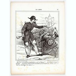
En Chine.
From the series "Caricatures du Prussien - Guerre des Duchés". Lithographed by Julés Pelcoq.
Date: Paris, 1864
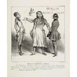
Bureau de remplacemens militaires. Y a Marchandise …(Plate 38)
Macaire personified the clever business man, who was willing at any time to throw moral and ethical principles overboard for a quick buck. His personality fitted exactly ...
Date: Paris, 1864
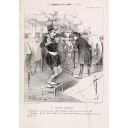
Les plaisirs des Champs-Elysées. Un guerrier electrisé. Le Physicien: tel est…
Published by Bauger, rue du Croissant 16 (lower left). Printed by Imprimeurs d'Aubert & Cie at Aubert, Place de la Bourse. Text was written by Alphonse Jean LAURE...
Date: Paris, 1864
![[Louis-Philippe teaching geography and mathematics in Reichenau, Switzerland]](/uploads/cache/47439-250x250.jpg)
[Louis-Philippe teaching geography and mathematics in Reichenau, Switzerland]
Lithograph by Chrétien after painting by David showing Louis-Philippe (1773-1850) the last king of France (1830-1848), in Switzerland teaching geography and mathematics ...
- $400 / ≈ €346
Date: Paris, 1864
Dutch landscape.
Attractive lithography showing a typical Dutch landscape, lithographed by F.H.Weissenbruch after a painting by W.Roelofs. Published in Kunst Kroniek.
- $50 / ≈ €43
Date: The Hague, 1865
Attaque & prise des forts du Pei-Ho Le 21 Août 1860, par les troupes Françaises et Anglaises.
In 1860, an Anglo-French force gathered at Hong Kong and then carried out a landing at Pei Tang on August 1, and a successful assault on the Taku Forts on August 21.This ...
- $500 / ≈ €433
Date: Paris, ca.1865
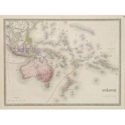
Océanie.
Detailed map of Australia, New Zealand, Indonesia and the Pacific. With a color key indicating English, French, Dutch, Spanish and Portuguese possessions in the region. F...
- $100 / ≈ €87
Date: Paris, 1865
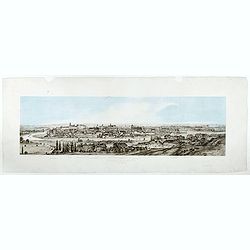
Widok Krakowa od Podgonza.
Bird's-eye view of Krakow city, with underneath the names of thirteen important buildings. Lithographed by J.Brydak after a photo by W. Rzewuskriego. Published by Czasu W...
- $750 / ≈ €649
Date: Krakow, ca. 1865
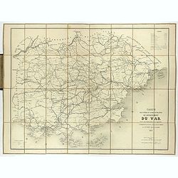
Carte routière et administrative du département du Var dressée sous l'administration et l'approbation de M. Montois, officier de la légion d'honneur, préfet , par J.B CHABET.
Folding-map of the Maritime Alps, and the Mediterranean coastline of Fréjus, Ramatuelle, St Tropez, Toulon. Engraved by Erhard, geographer and engraver (1821-1880) at th...
- $125 / ≈ €108
Date: Paris, 1865

Dutch windmill with sheeps.
Attractive lithography showing a typical Dutch windmill with sheep's on foreground, lithographed by F.H.Weissenbruch after a painting by Jan van Lokhorst. Published in Ku...
- $60 / ≈ €52
Date: The Hague 1866
![(2 charts of Shri Lanka) Mer des Indes - Ile de Ceylan - Partie Nord. Détroit de Palk et Golfe de Manaar.. [with] Partrie Sud...](/uploads/cache/23493-250x250.jpg)
(2 charts of Shri Lanka) Mer des Indes - Ile de Ceylan - Partie Nord. Détroit de Palk et Golfe de Manaar.. [with] Partrie Sud...
Two very large charts representing the northern and southern part of Sri Lanka and giving details about the Indian seacoast around the Gulf of Mannar and the Palk Strait....
- $750 / ≈ €649
Date: Paris, 1866

Paris fashion plate 577.
From Les Modes Parisiennes. Underneath the print are the names of the shops where the clothing's, perfumes, porcelains, flowers, etc., depicted in the engraving, are to b...
- $40 / ≈ €35
Date: Paris, 1866

Paris fashion plate. (584)
From Les Modes Parisiennes. Underneath the print are the names of the shops where the clothing's, perfumes, porcelains, flowers, etc., depicted in the engraving, are to b...
- $30 / ≈ €26
Date: Paris, 1866

Paris fashion plate. (120)
From Les Modes Parisiennes. Underneath the print are the names of the shops where the clothing's, perfumes, porcelains, flowers, etc., depicted in the engraving, are to b...
- $25 / ≈ €22
Date: Paris, 1866
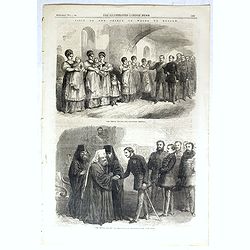
The Prince visiting the foundling hospital. / The Prince visiting the Metropolitan Archbishop.
Two engravings shown Albert Edward the Prince of Wales visiting Moscow from the Illustrated London News.
- $10 / ≈ €9
Date: London, 1866
Carta del Gran Banco de Bahama parte de la Isla de Cuba y Costa de la Florida.
A large marine chart, engraved by Juan Noguera and C.Marquerie, produced by the Direccion de Hydrografia, under the direction of Jose de Quesada, who was the then chief o...
- $1750 / ≈ €1515
Date: Madrid, 1858-1866
Nord America mit Westindien. . .
A superbly engraved and colored map of North America and the West Indies with a host of place names and meticulously rendered topography.Includes an inset of the Aleutian...
Date: Weimar, 1867
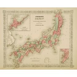
Johnson's Japan Nippon, Kiusiu, Sikok, Yesso. . .
A detailed steel-engraved map of Japan with inset maps of Yes and the Japanese Kuriles and Bay of Nagasaki. The map shows the island Argonaut labeled as Takashima (Ulleun...
- $175 / ≈ €151
Date: New York, 1867
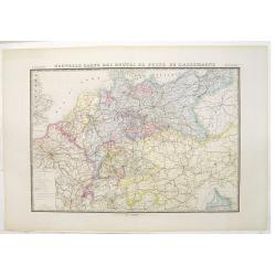
Nouvelle carte des routes de poste de l'Allemagne.
Large post road maps map of Germany, Poland, Austria, Franc, Switzerland, Austria and the Low Countries published by A. Logerot and engraved by C.Dyonnet.The mapsmakes di...
- $350 / ≈ €303
Date: Paris, A. Logerot, c.1867
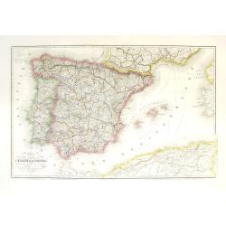
Carte géographique, physique et politique des royaumes d'Espagne et de Portugal indiquant les chemin fer en exploitations, ceux en cours d'éxécutions
Very large, highly detailed and uncommon map of Spain, Portugal and the northern coast of Africa. The map shows according to the title: rail roads, main interregional rou...
Date: Paris, c.1867
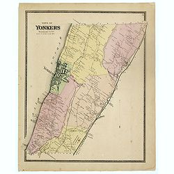
Town of Yonkers Westchester Co. NY
Fine lithographed map of the town of Yonkers. The map provides the names of specific homeowners, as well as information about the occupations and physical locations of th...
Date: New York, 1867
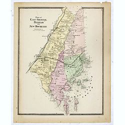
Plans of East Chester Pleham and New Rochelle. Westchester Co.
Fine lithographed map of East Chester Pelham and New Rochelle. The map provides the names of specific homeowners, as well as information about the occupations and physica...
Date: New York, 1867
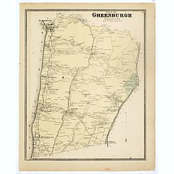
Town of Greenburgh.
Fine lithographed map of the town of Greenburgh. The map provides the names of specific homeowners, as well as information about the occupations and physical locations of...
Date: New York, 1867
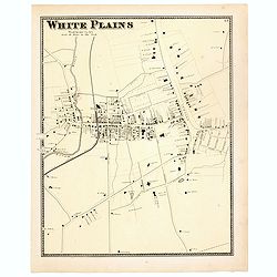
White Plains.
Fine lithographed map of White Plains. The map provides the names of specific homeowners, as well as information about the occupations and physical locations of the vario...
Date: New York, 1867
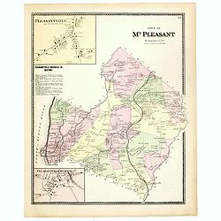
Town of Mt Pleasant. Westchester Co. NY.
Fine lithographed map of the town of Mt Pleasant. The map provides the names of specific homeowners, as well as information about the occupations and physical locations o...
Date: New York, 1867
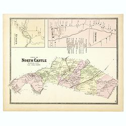
Town of North Castle.
Fine lithographed map of the town of North Castle. The map provides the names of specific homeowners, as well as information about the occupations and physical locations ...
Date: New York, 1867
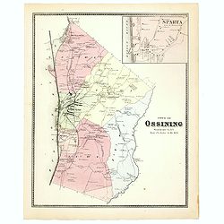
Town of Ossining. Westchester Co. NY.
Fine lithographed map of the town of Ossining. The map provides the names of specific homeowners, as well as information about the occupations and physical locations of t...
Date: New York, 1867
Town of New Castle. Westchester Co. NY.
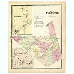
Fine lithographed map of the town of New Castle. The map provides the names of specific homeowners, as well as information about the occupations and physical locations of...
Date: New York, 1867
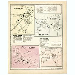
Mount Kisco / Bedford / Katonah / Bedford Station.
Fine lithographed map of Mount Kisco / Bedford / Katonah / Bedford Station. The map provides the names of specific homeowners, as well as information about the occupation...
Date: New York, 1867
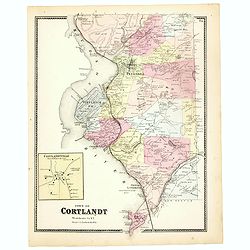
Town of Cortlandt.
Fine lithographed map of the town of Cortlandt. The map provides the names of specific homeowners, as well as information about the occupations and physical locations of ...
- $90 / ≈ €78
Date: New York, 1867
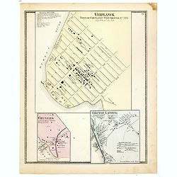
Town of Verplanck / Crugers / Croton Landing.
Fine lithographed map of the town of Verplanck / Crugers / Croton Landing. The map provides the names of specific homeowners, as well as information about the occupations...
- $90 / ≈ €78
Date: New York, 1867
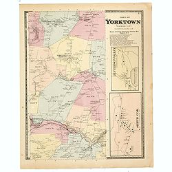
Town of Yorktown.
This is a fine lithographed map of Yorktown. The map provides the names of specific homeowners, as well as information about the occupations and physical locations of the...
- $90 / ≈ €78
Date: New York, 1867