Browse Listings
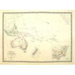
Nouvelle carte de l'Océanie dressée d'après les documents les plus récents par A. Vuillemin, géographe.
Very large, highly detailed and uncommon map of the Pacific with Australia and New Zealand, with inset map of "Partie de l'Australie (Nouvelle Galles du Sud) et Vict...
Date: Paris, 1876
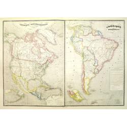
Amérique septentrionale dressée par C.V. Monin. . . / Amérique méridionale. . .
Two maps on one sheet. North America to the left, shows major cities, political divisions, and areas of Indian habitation for North America and the West Indies and state ...
- $300 / ≈ €260
Date: Paris, c.1876
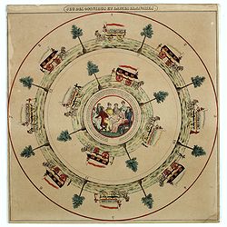
![Jules Verne. Le Tour du Monde en 80 jours. [Goose game board inspired by Jules Verne's novel Tour du Monde en 80 jours.]](/uploads/cache/44962-250x250.jpg)
Jules Verne. Le Tour du Monde en 80 jours. [Goose game board inspired by Jules Verne's novel Tour du Monde en 80 jours.]
This Goose game board is inspired by Jules Verne's novel whose boxes are illustrated with town views and figures and the center is occupied by a world map. Vignette illus...
- $1100 / ≈ €952
Date: Paris, 1876
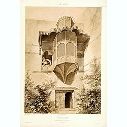
Beyt El-Emyr.
Lithograph by Mouilleron representing a young woman looking over a beautiful moucharabieh. From the author's "L'Art Arabe d'après les monuments du Kaire?". Emi...
Date: Paris, 1877
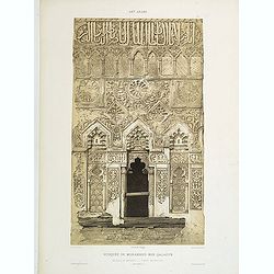
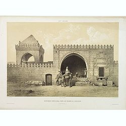
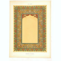
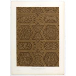
Mosquée de Mohammed Ben Qalaoûn. Details du Minaret Partie Inférieure. (XIVe. siècle)
Highly decorative lithography by Asselineau, showing architectural details of the minaret of Qalaoûn's mosque in Cairo. From the author's "L'Art Arabe d'après les ...
- $150 / ≈ €130
Date: Paris, 1877
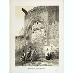
Porte du Palais du Soultan Beybars. (XIIIe. siècle)
Highly decorative lithography by Ch. Fichot, showing the walled-up entrance of Sultan Beybars' palace. From the author's "L'Art Arabe d'après les monuments du Kaire...
Date: Paris, 1877
Tombeau d'un Emir. (XIIIe. siècle)
Highly decorative lithography by Ch. Fichot, representing the mausoleum of an emir. From the author's "L'Art Arabe d'après les monuments du Kaire". Emile Priss...
- $150 / ≈ €130
Date: Paris, 1877
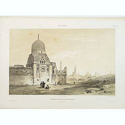
Tombeau du Soultan Tarabey. (XVIe. siècle)
Highly decorative lithography by Ch. Fichot, representing Sultan Tarabey's mausoleum. From the author's "L'Art Arabe d'après les monuments du Kaire?". Emile Pr...
Date: Paris, 1877
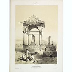
Monument Sépulcral près de Kymân El-Gyouchy. (XVIIIe. siècle)
Highly decorative lithography by Asselineau, representing a mausoleum. From the author's "L'Art Arabe d'après les monuments du Kaire?". Emile Prisse d'Avennes,...
Date: Paris, 1877
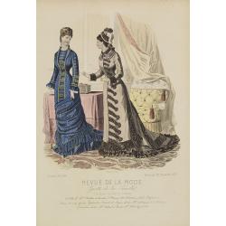
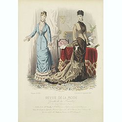
Paris fashion plate. (308)
From Revue de la Mode. Gazette de la Famille . Underneath the print are the names of the shops where the clothing's, perfumes, porcelains, flowers, etc., depicted in the ...
Date: Paris, 1877

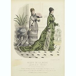
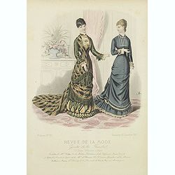
Paris fashion plate. (306)
From "Revue de la Mode - Gazette de la Famille". Underneath the print are the names of the shops where the clothing's, perfumes, porcelains, flowers, etc., depi...
Date: Paris, 1877

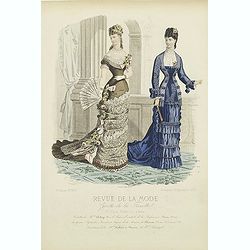
Paris fashion plate. (304)
From "Revue de la Mode - Gazette de la Famille". Underneath the print are the names of the shops where the clothing's, perfumes, porcelains, flowers, etc., depi...
Date: Paris, 1877
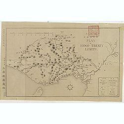
(Plan of Hiogo Treaty Limits)
Map of the new prefecture with Japanese and English descriptions. In lower right an key to "Position of Government Office, boundaries, road and railways. On January ...
Date: Meiji 10 = 1877
Paris fashion plate. (285)
From "Revue de la Mode - Gazette de la Famille". Underneath the print are the names of the shops where the clothing's, perfumes, porcelains, flowers, etc., depi...
- $30 / ≈ €26
Date: Paris, 1877
Paris fashion plate. (297)
From "Revue de la Mode - Gazette de la Famille". Underneath the print are the names of the shops where the clothing's, perfumes, porcelains, flowers, etc., depi...
- $40 / ≈ €35
Date: Paris, dated 1877
Paris fashion plate. (299)
From "Revue de la Mode - Gazette de la Famille". Underneath the print are the names of the shops where the clothing, perfumes, porcelains, flowers, etc., depict...
- $30 / ≈ €26
Date: Paris, dated 1877
Paris fashion plate. (311)
From "Revue de la Mode - Gazette de la Famille". Underneath the print are the names of the shops where the clothing's, perfumes, porcelains, flowers, etc., depi...
- $30 / ≈ €26
Date: Paris, dated 1877
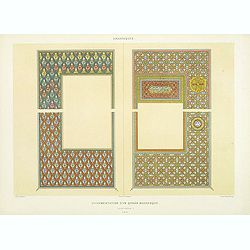
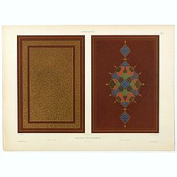
Arabesques. - Ornementation d'un Qoran Mauresque (XVIIIe siècle)
Lithographed by Daumont. From the author's "L'Art Arabe d'après les monuments du Kaire…". Emile Prisse d'Avennes, Orientalist and Muslim convert, obsessive i...
Date: Paris, 1877
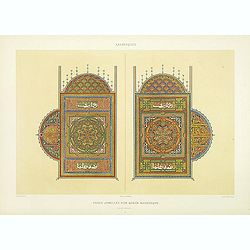
Arabesques. - Pages jumelles d'un qorân mauresque. (XVIIIe siècle)
Lithographed by Daumont. From the author's "L'Art Arabe d'après les monuments du Kaire…". Emile Prisse d'Avennes, Orientalist and Muslim convert, obsessive i...
Date: Paris, 1877
Art arabe. - Séances de Hariry.
Lithographed by Daumont. From the author's "L'Art Arabe d'après les monuments du Kaire…". Emile Prisse d'Avennes, Orientalist and Muslim convert, obsessive i...
Date: Paris, 1877
Art arabe. - Mosquée d'El-Bordeyny.
Lithographed by Daumont. From the author's "L'Art Arabe d'après les monuments du Kaire...". Emile Prisse d'Avennes, Orientalist and Muslim convert, obsessive i...
Date: Paris, 1877
Art arabe. - Maison appelée beyt el-Tcheleby.
Lithographed by Daumont. From the author's "L'Art Arabe d'après les monuments du Kaire…". Emile Prisse d'Avennes, Orientalist and Muslim convert, obsessive i...
Date: Paris, 1877
Art arabe. - Mosquée de Qaytbay.
Lithographed by Daumont. From the author's "L'Art Arabe d'après les monuments du Kaire…". Emile Prisse d'Avennes, Orientalist and Muslim convert, obsessive i...
- $50 / ≈ €43
Date: Paris, 1877
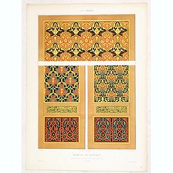
Art arabe. - Mosquée cathédrale de qous assemblage & détails des pièces du mimbar. . .
Lithographed by Daumont. From the author's "L'Art Arabe d'après les monuments du Kaire…". Emile Prisse d'Avennes, Orientalist and Muslim convert, obsessive i...
Date: Paris, 1877
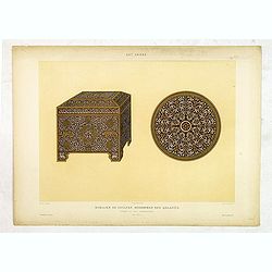
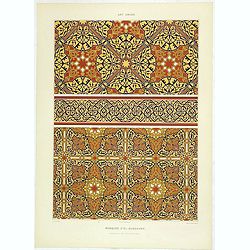
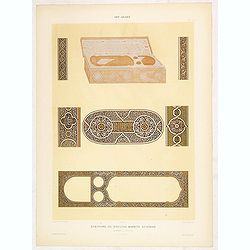
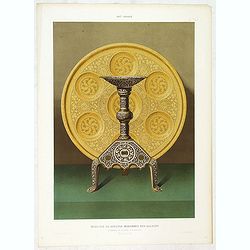
Art arabe. - Mobilier de soultan Mohammed Ben Qalaoûn coffret et plat damasquinés. . .
Lithographed by Daumont. From the author's "L'Art Arabe d'après les monuments du Kaire…". Emile Prisse d'Avennes, Orientalist and Muslim convert, obsessive i...
- $50 / ≈ €43
Date: Paris, 1877
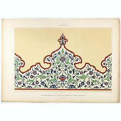
Arabesques. - Couronnement de la porte du Minbar de Gama Sysaryeh.
Lithographed by Daumont. From the author's "L'Art Arabe d'après les monuments du Kaire…". Emile Prisse d'Avennes, Orientalist and Muslim convert, obsessive i...
- $50 / ≈ €43
Date: Paris, 1877
Arabesques. - Incrustations en stuc sur pierre.
Lithographed by Daumont. From the author's "L'Art Arabe d'après les monuments du Kaire…". Emile Prisse d'Avennes, Orientalist and Muslim convert, obsessive i...
- $30 / ≈ €26
Date: Paris, 1877
![[Schwarzes Meer] Nr 1](/uploads/cache/37946-250x250.jpg)
[Schwarzes Meer] Nr 1
Uncommon map of the Black Sea and Crimea. In lower part a scale. Prepared by Friedrich Handtke (1815-1879). Map set in a decorative border.
- $120 / ≈ €104
Date: Glogau, Leipzig, 1877
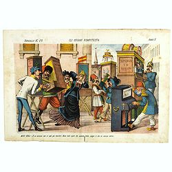
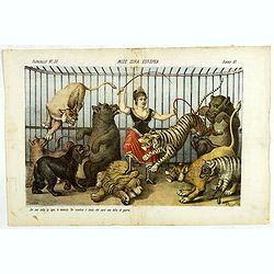
Gli organi rompitesta. Papagallo No. 52. Anno V.
Design by Augusto Grossi. Taken from the Italian satirical newspaper Il Papagallo, a satirical magazine founded in January 1873 by Augusto Grossi (1835-1919), which speci...
Date: Bologne, 1877
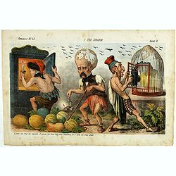
I tre diogene. Papagallo No. 43. Anno V.
Satirical lithographed plate published in the supplement to the political newspaper charivaric Papagallo / Le Perroquet N. 43, in the 5th year, published in Bologna. Sati...
Date: Bologne, 1877
Art arabe. - Ecritoire du soultan Bahrite Schâban. . .
Lithographed by Daumont. From the author's "L'Art Arabe d'après les monuments du Kaire…". Emile Prisse d'Avennes, Orientalist and Muslim convert, obsessive i...
- $50 / ≈ €43
Date: Paris, 1877
Art arabe. - Tombeau du soultan qansou el-Ghoury.
Lithographed by Daumont. From the author's "L'Art Arabe d'après les monuments du Kaire…". Emile Prisse d'Avennes, Orientalist and Muslim convert, obsessive i...
- $50 / ≈ €43
Date: Paris, 1877
Art arabe. - Mosquée cathédrale de qous Détails du Mimbar. . .
Lithographed by Daumont. From the author's "L'Art Arabe d'après les monuments du Kaire…". Emile Prisse d'Avennes, Orientalist and Muslim convert, obsessive i...
- $50 / ≈ €43
Date: Paris, 1877
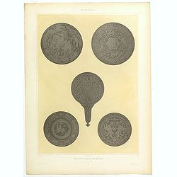
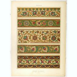
Arabesques. - Miroirs a main en métail. . .
Lithographed by Daumont. From the author's "L'Art Arabe d'après les monuments du Kaire…". Emile Prisse d'Avennes, Orientalist and Muslim convert, obsessive i...
- $75 / ≈ €65
Date: Paris, 1877
Arabesques. - Ornementation d'un Qorân mauresque. . .
Lithographed by Daumont. From the author's "L'Art Arabe d'après les monuments du Kaire…". Emile Prisse d'Avennes, Orientalist and Muslim convert, obsessive i...
- $75 / ≈ €65
Date: Paris, 1877
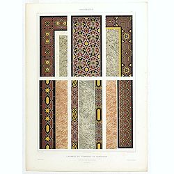
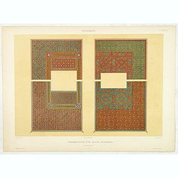
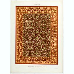
Arabesques. - Lambris du tombeau de Barsabay. Détails des mosaïques.
Lithographed by Daumont. From the author's "L'Art Arabe d'après les monuments du Kaire…". Emile Prisse d'Avennes, Orientalist and Muslim convert, obsessive i...
- $75 / ≈ €65
Date: Paris, 1877
Arabesques. - Reliure a recouvrement.
Lithographed by Daumont. From the author's "L'Art Arabe d'après les monuments du Kaire…". Emile Prisse d'Avennes, Orientalist and Muslim convert, obsessive i...
- $75 / ≈ €65
Date: Paris, 1877
Arabesques. - Vase en Bronze damasquiné orné de martichores.
Lithographed by Daumont. From the author's "L'Art Arabe d'après les monuments du Kaire…". Emile Prisse d'Avennes, Orientalist and Muslim convert, obsessive i...
- $90 / ≈ €78
Date: Paris, 1877
Arabesques. - Application de découpures en papier.
Lithographed by Daumont. From the author's "L'Art Arabe d'après les monuments du Kaire…". Emile Prisse d'Avennes, Orientalist and Muslim convert, obsessive i...
- $75 / ≈ €65
Date: Paris, 1877
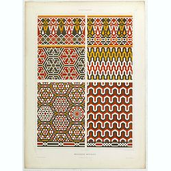
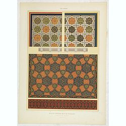
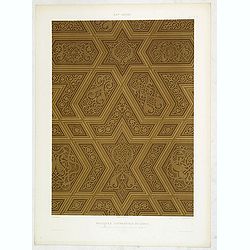
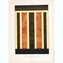
Arabesques. - Mosaïques Murales.
Lithographed by Daumont. From the author's "L'Art Arabe d'après les monuments du Kaire…". Emile Prisse d'Avennes, Orientalist and Muslim convert, obsessive i...
Date: Paris, 1877
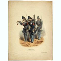
Types militaires - Clairons de Chasseurs à pied. (Pl 40)
Militariary plate depecting two buglers, lithographed by Becquet frères, rue des Noyers, 37.
Date: Paris, chez Bequet , 1877
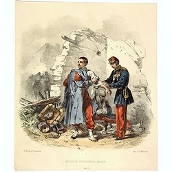
L'Armée Française - Medecin chirurgien Major. (Pl 32)
Lithography by H. Lalaisse depicting an army doctor and injured soldiers. François Hippolyte Lalaisse was born in Nancy in 1812 and died in Paris in 1884. He was a Frenc...
Date: Paris, 1877
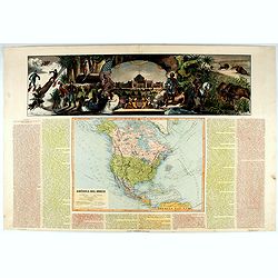
América del Norte.
Beautiful, large map of North America with a stunning panorama at the top of figures representing the continents, etc. A rare and decorative map. From "Atlas geográ...
- $550 / ≈ €476
Date: Madrid, 1877
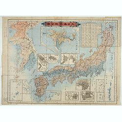
Kaisei dosen Dai Nihon yochi zenzu.
Title in top : "Dai Nihon yochi zenzu.". Showing Japan, Korea and in an inset Hokkaido. Folding copperplate print in Japanese. Relief shown by hachures. Include...
- $350 / ≈ €303
Date: Tokyo, Meiji 10 or 1877
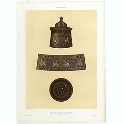
Art arabe. - Mobilier de soultan Mohammed Ben Qalaoûn flambeau et plateau d'alcarazas. . .
Lithographed by Daumont. From the author's "L'Art Arabe d'après les monuments du Kaire…". Emile Prisse d'Avennes, Orientalist and Muslim convert, obsessive i...
Date: Paris, 1877

Paris fashion plate. (305)
From "Revue de la Mode - Gazette de la Famille". Underneath the print are the names of the shops where the clothing's, perfumes, porcelains, flowers, etc., depi...
Date: Paris, 1877
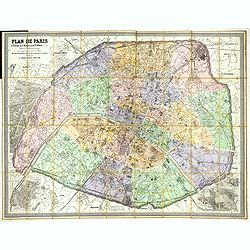
Plan de Paris A l'Echelle de 2 Millim. pour 2.5 Metres . . . Indiquant les Nouveaux percements et les changements de mons de Voies publiques Avec Plans Supplmentaries Pour Les Bois De Boulogne et De Vicennes . . .
Magnificent map of the urban redevelopments planned for Paris at the end of the 19th century. The map has been updated, with insets showing supplemental plans for the Boi...
- $600 / ≈ €519
Date: Paris, 1878
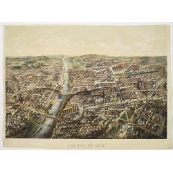
Angers 1878.
Large bird's-eye view of Angers after Mollay and lithographed by Muller.
- $250 / ≈ €216
Date: Paris, Lemercier, ca. 1878
Miss Cora Europea. Papagallo No. 35. Anno VI.
Miss Europa taming the lion (Russia) with other nations shown as animals. Design by Augusto Grossi. Taken from the Italian satirical newspaper Il Papagallo, a satirical m...
Date: Bologne, 1878
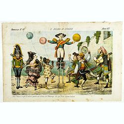
Il bolero in Ispagnia. Papagallo No. 42. Anno VI.
About Spanish expansion, with balloons symbolizing Cuba, Havana, Cortes. Taken from the Italian satirical newspaper Il Papagallo, a satirical magazine founded in January ...
Date: Bologne, 1878
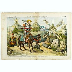
Il Don Cihsciotte a complici. Papagallo No. 48. Anno VI.
Taken from the Italian satirical newspaper Il Papagallo, a satirical magazine founded in January 1873 by Augusto Grossi (1835-1919), which specialized in color-printed ca...
Date: Bologne, 1878
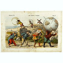
Pesi Graditi ee sgraditi. Papagallo No. 6. Anno VI.
Translation of the legend: "Several weights, each one has to carry its weight, the more serious it is, the longer the trip seems to be, and they will come sooner or ...
Date: Bologne, 1878
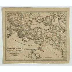
Karte des Türkischen Reiches in Europa und Asien . . .
Map of Turkish Empire.
- $35 / ≈ €30
Date: Breslau, 1878
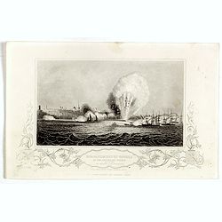
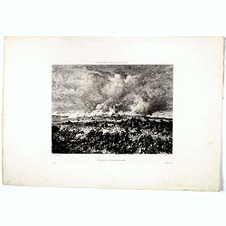
Bombardment of Odessa by the English and French April 22 1854, explosion on the imperial mole . . .
Scene from the Crimea war, showing a bombardment of Odessa, 22nd April 1854 (during Crimean War, 1853-56), by English and French forces, explosion imperial mole (breakwat...
- $30 / ≈ €26
Date: London, ca. 1879
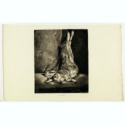
Le Lapin.
Nice etching by Ch. Waltner after a painting of Manet.
- $20 / ≈ €17
Date: Paris, 1879
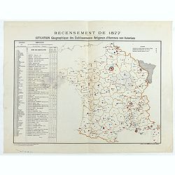
Recensement de 1877. Situation Géographique des Etablissements Religieux d'Hommes non Autorisés.
Rare map showing private secondary schools for boys created by unauthorized religious congregations. On sale at M. Devillaire, 43, R. du Four St. Germain in Paris / at M....
Date: Paris, F. Appel, 1879
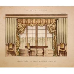
Grande baie de salle a manger Louis XVI.
Very decorative and colorful lithography of an elegant French interior. From La Tenture Française, published by G.MathiÞre, 32/34 Rue de Charonne, Paris.
- $75 / ≈ €65
Date: Paris, 1880
Sint Catharinakerk te Eindhoven
Uncommon print of St.Catharina church of Eindhoven, built by the well-known architect P.Cuijpers. Published in Katholieke Illustratie .
- $85 / ≈ €74
Date: 'sHertogenbosch, 1880
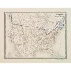
États-Unis et Nouvelle Bretagne.
A detailed map of the United States. All different States are divided by an orange border line.
- $120 / ≈ €104
Date: Paris, 1880
![[Title page] La France Nouvel Atlas illustré des Départements & des Colonies . . .](/uploads/cache/17248-250x250.jpg)
[Title page] La France Nouvel Atlas illustré des Départements & des Colonies . . .
Title page from a French atlas, the decoration executed in Neo-Gothic style. In bottom part a globe and a map of France, to the left an Atlas-figure.Engraved by Villerey.
- $30 / ≈ €26
Date: Paris, 1880

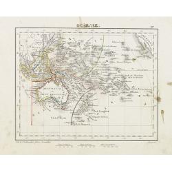
Océanie.
Decorative map of the Pacific Ocean including Indonesia, Australia, New Zealand and California. Lower right inset map Détails de la Nouvelle Galles Méridionale , includ...
- $120 / ≈ €104
Date: Paris 1880
Océanie.
Small map of Australia, New Zealand and the Pacific. The area is divided in different parts. Lithographed by C.Callewaert from Brussels.
- $80 / ≈ €69
Date: Bruxelles, c. 1880
![Sint-Catharinakerk te Eindhoven [with plan]](/uploads/cache/28813-250x250.jpg)
Sint-Catharinakerk te Eindhoven [with plan]
Uncommon wood engraved print of St.Catharina church in Eindhoven, built by the well-known architect P.Cuijpers. Published in Kunstkronijk. This wood engraving is similar ...
- $85 / ≈ €74
Date: Amsterdam, c.1880
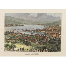
Nagasaki. - Vue générale. Dessin de Taylor, après une photographie.
A bird's-eye view showing Nagasaki Bay. After a photograph by Taylor. Engraved in wood by A.Kohl.Showing the town and natural harbour of Nagasaki.In the harbour the islan...
- $150 / ≈ €130
Date: Paris, 1880
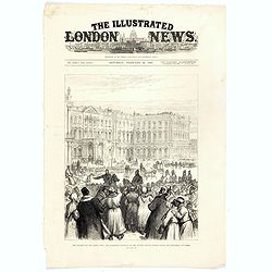
The attempt on the Czar's life: the Soltykoff dorway of the Winter Palace . . .
A panorama of the Winter Palace published in the Illustrated London News of 1880.
- $20 / ≈ €17
Date: London, 28 February, 1880
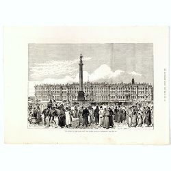
The attempt on the Czar's life: The Winter Palace, St Petersburg.
A panorama of the Winter Palace with an attempt on the Czar's life published in the Illustrated London News of 28 February, 1880.
- $15 / ≈ €13
Date: London, 28 February, 1880
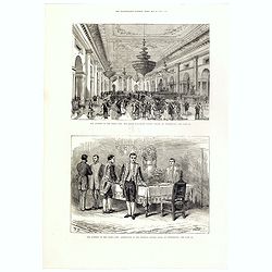
The attempt on the Czar's life: The Grand Ball-Room . . .
A panorama of the Winter Palace with an attempt on the Czar's life published in the Illustrated London News of 28 February, 1880.
- $15 / ≈ €13
Date: London, 28 February, 1880
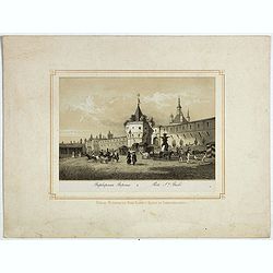
Porte Ste Barbe.
View of the gate of St. Barbe. Title in Russian and French.
- $50 / ≈ €43
Date: Russia, ca. 1880
Bataille de la Moskova.
Etching of a battle in which Napoleon's army fought the Russian army of general Kutuzov on 7 September 1812.Etched by Auguste II. Boulard (1852–1927) after a painting b...
- $50 / ≈ €43
Date: Paris, 1880
Jeu des omnibus et dames blanches.
The name of 'Dames Blanches', or white ladies, was bestowed on the two-compartment public omnibus that plied the Madeleine-Bastille run in Paris. In 1937 the brand Hermè...
- $250 / ≈ €216
Date: Paris, ca 1880
![[ A set of four humorous illustrations 'Le Malade Imaginaire'.]](/uploads/cache/46323-250x250.jpg)
[ A set of four humorous illustrations 'Le Malade Imaginaire'.]
A humorous illustration from the "Le Malade Imaginaire" - numbers 68. Shows a smiling, frothing syringe, with hands-on hips surrounded by dancing witches. Small...
Date: Paris, ca. 1880
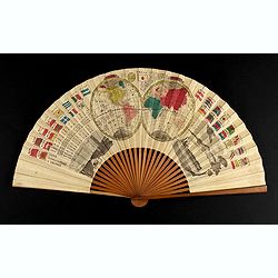
A folding fan with a map of Japan, double hemisphere world map and views of Yokohama and Edo.
The folding fan showing a map of Japan on one side, and on the other side a double hemisphere world map, two city views, and a train. Read more about folding fans andcar...
- $750 / ≈ €649
Date: Japan, ca. 1880
![Fantaisie Funebre [ Funeral Fantasy.]](/uploads/cache/46336-250x250.jpg)
Fantaisie Funebre [ Funeral Fantasy.]
With text below the illustration "-Qui, parlons-en: vous faites un malade bien agréable... j'voudrais... qu'vous n'ayez personne à votre enterrement ! Design by Le...
- $80 / ≈ €69
Date: Paris, ca. 1880
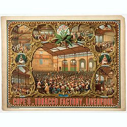
Cope's Tobacco Factory Liverpool.
The company was started in 1848 in Old Post Office Street Liverpool by Thomas Cope and George Cope. By the 1880s the company was employing nearly 2000 staff and producing...
- $750 / ≈ €649
Date: Paris, 1880
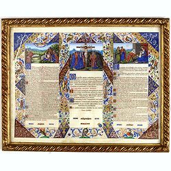
Canon Altar.
Each panel is handwritten in red and black ink, with beautiful golden blue or red initials; it is part of a rich and beautiful gouache and gold polychrome frame foliage f...
Date: ca. 1880
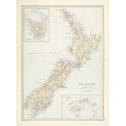
New Zealand.
Very detailed map of New Zealand, with inserts of Tasmania and Fiji Islands. The map was printed from lithographic stones taken from a hand-engraved steel plate. The cart...
Date: Edinburg, ca 1881
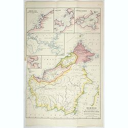
Borneo, shewing the lands ceded by the sultans of Brunei & Sulu to the British North Borneo Company.
Chromo lithographed folded map showing Borneo with Brunei, Sarawak, British North Borneo Company or Sabah. One of the first maps showing the British North Borneo Company ...
- $1750 / ≈ €1515
Date: London, Stanford, 1881
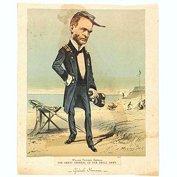
William Tecuseh Sherman The Great General of our small army.
Illustration of General William T. Sherman, full-length portrait, standing, facing right, holding binoculars, his sword resting on a campstool behind him. Published in Ne...
- $100 / ≈ €87
Date: New York, 1881
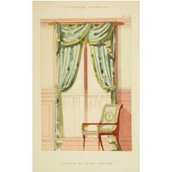
Fenètre et siège empire.
Very decorative and colorful lithography of an elegant French interior. From La Tenture Française, published by G.Mathière, 32/34 Rue de Charonne, Paris.
- $50 / ≈ €43
Date: Paris, 1882
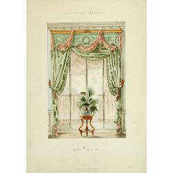
Baie Louis XVI. . .
Very decorative and colorful lithography of an elegant French interior. From La Tenture Française published by G.Mathière, 32/34 Rue de Charonne, Paris.
Date: Paris, 1882