Browse Listings
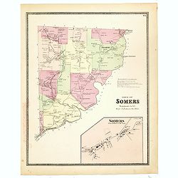
Town of Somers.
This is a fine lithographed map of the town of Somers. The map provides the names of specific homeowners, as well as information about the occupations and physical locati...
- $90 / ≈ €78
Date: New York, 1867
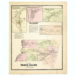
Town of North Salem.
Fine lithographed map of the town of North Salem. The map provides the names of specific homeowners, as well as information about the occupations and physical locations o...
- $90 / ≈ €78
Date: New York, 1867
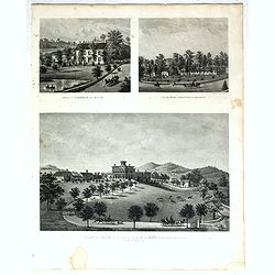
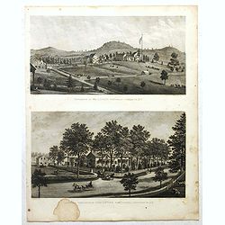
Property of F.A.Halstead Bedford Station, The Halstead Homestead at Bedford and Inland Vale residence of J.S.Libby, Westchester Co. NY North Salem.
Three heliographic prints on one sheet : "Property of F.A.Halstead Bedford Station", "The Halstead Homestead at Bedford" and "Inland Vale residen...
- $100 / ≈ €87
Date: New York, 1867
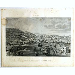
View of Brewsters' Putnam Co.N.Y.
Heliographic print of Brewsters' Putnam Co.N.Y." after a design by R.K.Sneden.From Beer's famous county atlas "Atlas of New York and vicinity, a documentary rec...
- $100 / ≈ €87
Date: New York,1867
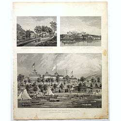
Résidence of WM H.Drew Southeast Putnam Co.N.Y / Lake Farm Résidence of John V.Storm East Fiskill Dutches Co.N.Y.
Two heliographic prints on one sheet : " Résidence of WM H.Drew Southeast Putnam Co.N.Y / Lake Farm Résidence of John V.Storm East Fiskill Dutches Co.N.Y." af...
- $100 / ≈ €87
Date: New York,1867

Todd Homestead / Résidence of B. Travis Katonah N.Y / Reisig & HexamersBarn Ivy Hill / Résidence of W.F Bearns
Four heliographic prints on one sheet : "Todd Homestead / Résidence of B. Travis Katonah N.Y / Reisig & HexamersBarn Ivy Hill / Résidence of W.F Bearns "I...
- $100 / ≈ €87
Date: New York,1867
Residence of A.S. Doane Doanesburg Putnam Co. N.Y. - N. L. Thompsons's lake Mahopac - The Gregory House lake Mahopac Putnam Co N. Y. Lewis H. Gregory Proprietor.
Three heliographic prints on one sheet : "Residence of A.S. Doane Doanesburg Putnam Co. N.Y. (120x150mm.) / N. L. Thompsons's lake Mahopac (120 x 160mm.) / The Grego...
- $100 / ≈ €87
Date: New York,1867
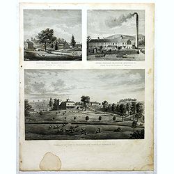
Mount Vernon Valley Residence of S.J. Powers / Borden condensed milk factory brewsters N.Y / Residence of Dan D. Chamberlain South East Putman Co. N.Y.
Three heliographic prints on one sheet : "Mount Vernon Valley Residence of S.J. Powers (135 x 155mm.) / Borden condensed milk factory brewsters N.Y (135 x 155mm.) / ...
- $100 / ≈ €87
Date: New York,1867
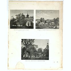
"Old Dutch church, "Sleepy Hollow" / Residence of A.B Baylis esq Bedford village N.Y / "Sunny side" former residence of Washington Irving."
Three heliographic prints on one sheet : "Old Dutch church, "Sleepy Hollow" / Residence of A.B Baylis esq Bedford village N.Y / "Sunny side" form...
- $100 / ≈ €87
Date: New York,1867
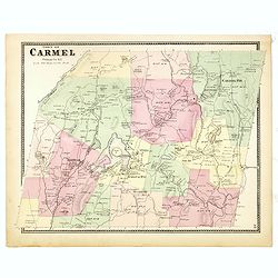
Town of Carmel.
Fine lithographed map of the town of Carmel. From : "Atlas of New York and vicinity" published by Beers, Ellis & Soule, 95 Maiden Lane, New York. The map pr...
Date: New York, 1867
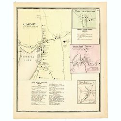
Town of Carmel / Towners Station / South East Centre / Mill Town.
Fine lithographed map of the town of Carmel / Towners Station / South East Centre / Mill Town. From "Atlas of New York and vicinity" published by Beers, Ellis ...
Date: New York, 1867
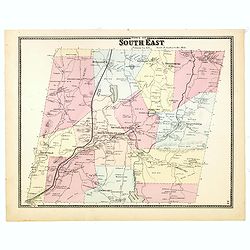
Town of South East.
Fine lithographed map of the town of South East. From : "Atlas of New York and vicinity" published by Beers, Ellis & Soule, 95 Maiden Lane, New York.The map...
Date: New York, 1867
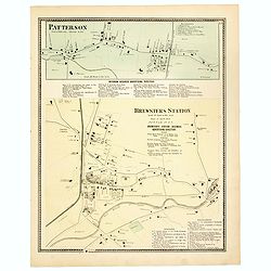
Town of Patterson / Brewsters Station.
Fine lithographed map of the town of Patterson / Brewsters Station. From : "Atlas of New York and vicinity" published by Beers, Ellis & Soule, 95 Maiden Lan...
Date: New York, 1867
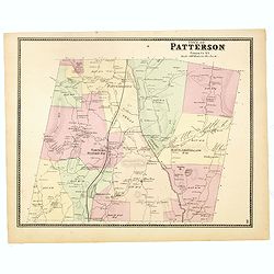
Town of Patterson.
Fine lithographed map of the town of Patterson. From : "Atlas of New York and vicinity" published by Beers, Ellis & Soule, 95 Maiden Lane, New York.The map ...
Date: New York, 1867
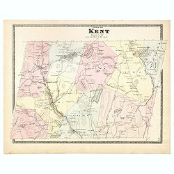
Town of Kent.
Fine lithographed map of the town of Kent. From :"Atlas of New York and vicinity" published by Beers, Ellis & Soule, 95 Maiden Lane, New York.The map provid...
Date: New York, 1867
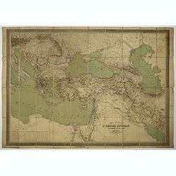
Carte général de L'Empire Ottoman en Europe et en Asie. . . dressée par Henri Kiepert.
Large School wall map of Turkish Empire printed in chromo-lithography. Published by Dieter Reimer and printed by Ferdind Barth in Berlin.This rare map has two insets in l...
- $700 / ≈ €606
Date: Berlin, Dieter Reimer, 1867
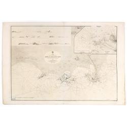
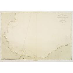
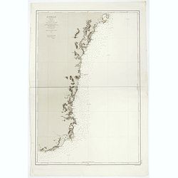
Arabia. Gulf of Aden - North Coast. Aden and Adjacent Bays..
Large chart focused east of Aden, in Yemen. With inset plan of Aden Anchorage in the upper right corner and a set of coastal profiles in the upper left corner.With latitu...
- $900 / ≈ €779
Date: London (1836) corrected to 1868
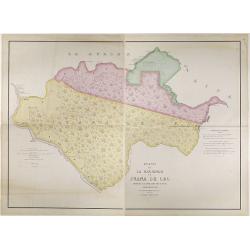
Plano de la Hacienda de Juana de Oro.
Wall-map sized map in 2 sheets, if joined 940 x 1300mm., showing the Hacienda (farm) of Juana de Oro in Ecuador. The cocoa farm was owned by Mrs. Leonor Carbo of Higgins ...
Date: Guayaquil ( Equateur), 1868

Den Briel.
Attractive lithography showing a typical Dutch street scene of Den Briel in the middle of the 19th century, lithographed by A.C.Cramer after a painting by Cornelis Spring...
- $50 / ≈ €43
Date: The Hague, 1869

Carte générale de la mer des Indes dressée par P. Daussy et P.E. Wissocq, grave par Chassant, ecrit par J.M. Hacq.
Magnificent and detailed large-scale chartdepicting the Indian ocean, with east coast of Africa, Madagascar, Arabian Peninsula, India, China, etc .Including the West coa...
- $1000 / ≈ €865
Date: Paris, 1837-1869
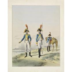
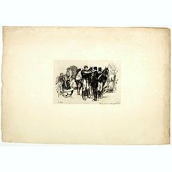
Guides interprètes de l'armee d'Angleterre.
A very decorative lithography of English soldiers about 1804.
- $50 / ≈ €43
Date: France, c.1870

Paris fashion plate. (115)
From Les Modes Parisiennes. Underneath the print are the names of the shops where the clothing's, perfumes, porcelains, flowers, etc., depicted in the engraving, are to b...
Date: Paris 1870

Paris fashion plate. (697)
From Les Modes Parisiennes. Underneath the print are the names of the shops where the clothing's, perfumes, porcelains, flowers, etc., depicted in the engraving, are to b...
Date: Paris, 1870

Paris fashion plate. (700)
From Les Modes Parisiennes. Underneath the print are the names of the shops where the clothing's, perfumes, porcelains, flowers, etc., depicted in the engraving, are to b...
Date: Paris 1870

Paris fashion plate. (697)
From Les Modes Parisiennes. Underneath the print are the names of the shops where the clothing's, perfumes, porcelains, flowers, etc., depicted in the engraving, are to b...
Date: Paris 1870
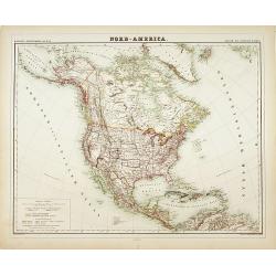
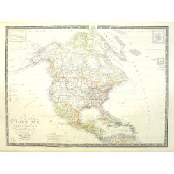
Carte de L'Amérique du Nord. . .
Detailed map of Nord America and Central America giving good detail along the east coast and the Lakes. Including San Francisco, Monterey, etc.With inset map of Dominican...
- $250 / ≈ €216
Date: Paris, 1870
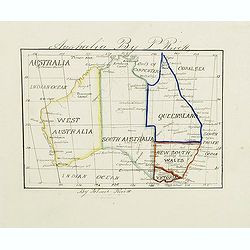
Australia by P.Rivett.
Manuscript map of Australia without Tasmania, prepared by Palmer Rivett, who was born around 1858 in Blundeston, Suffolk, England, where he spent most of his life. He was...
Date: c. 1860-1870
Carte de la Mer Noire. (1e Feuille). Du Bosphore à Mangalia et du Bosphore au Cap Kerempeh.
Very detailed chart of the Turkish part of the Black Sea including the towns of Constantinople (Istanbul) , Bourgas. Showing soundings in meters, lighthouses are marked w...
Date: Paris, 1860, updated for 1870
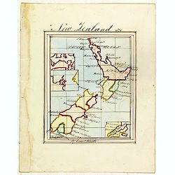
New Zealand 1870
Manuscript map of new Zealand, signed in lower border "By Ernst Pivett. Perhaps a school exercise map.
- $200 / ≈ €173
Date: London, ca. 1870
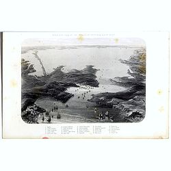
Birds-eye view of the Straits of Kertch & Sea of Azoff.
Steel engraving of the harbour at Sebastopol and the Straits of Kertch and Sea of Azoff in the Ukraine published by James Virtue around 1860.Title in upper margin. With a...
- $75 / ≈ €65
Date: London, 1870
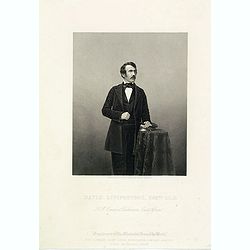
David Livingstone, ESQre L.L.D. H.M.Consul at Duillimane, East Africa.
Steel engraved portrait of David Livingstone (19 March 1813 – 1 May 1873), engraved by D.J.Pound after a photography by Mayall. Published as supplement to "The Ill...
- $300 / ≈ €260
Date: London, ca. 1870
![Veduta di Istambul. [Gouache]](/uploads/cache/45368-250x250.jpg)
Veduta di Istambul. [Gouache]
Very decorative view depicting Istanbul, in the style of Neapolitan gouaches. Features different Mosques and the shores of the Bosporus. Many ships, small and large, are ...
Date: Italy ?, ca. 1870
Mouzon près de la route de Villemonty 30 Aout 1810 - 2 heures
Military scene by Auguste Lançon (1836-1885), painter and etcher, was active during the war of 1870. Engaged in an ambulance of the press, he sent day by day his drawing...
- $100 / ≈ €87
Date: Paris, 1870
![[Satirical Cartoon] La difference qu'il y a entre un gendarme et de l'eau de Sedlitz?. . .](/uploads/cache/46539-250x250.jpg)
[Satirical Cartoon] La difference qu'il y a entre un gendarme et de l'eau de Sedlitz?. . .
A humorous French satirical cartoon asking the difference between a policeman and Eau de Sedlitz (a purgative liquid). The caption answers "one stops/arrests while t...
Date: Paris, ca 1870
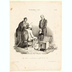
La Caricature (Journal) Ah! docteur, ce maudit siege m'a fait bien du mal.
[Ah! Doctor, this damn seat hurt me badly] A French lithograph showing a man dressed in a nightgown seated on a chair with a crest on the back. A stern faced doctor and a...
Date: Paris, 1870
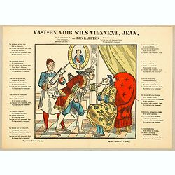
Va-t'en-voir s'ils viennent, Jean, ou Les Raretes.
[Go, see if they come John, or Rarities.] A nice fully colored litho print depicting a doctor examining an old man in an armchair from the eighteenth century. Behind the ...
Date: Paris, 1870
![[Game of the goose] Jeu du Jardin Zoologique / Thiergarten Spiel.](/uploads/cache/48344-250x250.jpg)
[Game of the goose] Jeu du Jardin Zoologique / Thiergarten Spiel.
Goose board game. With boxes numbered from 1 to 25. The boxes illustrate different animals.Below the title and the game rules in letterpress in French and German.N° 71 ...
- $150 / ≈ €130
Date: Wissembourg (Alsace), ca. 1870

Tōkyō Takanawa fūryō no zu' 東京高輪風凉図 (A View of Takanawa in Tokyo)
Woodblock print designed by Toyohara Kunichika and published by Yorozuya Magohei. Toyohara Kunichika (1835-1900) was a Ukiyoe painter. Also referred to as Kachoro, Ichios...
- $1500 / ≈ €1298
Date: Yokohama, (Meiji 3) 1870
![Bay of Bengal, compiled chiefly from government survey.. [2 sheets]](/uploads/cache/23495-250x250.jpg)
Bay of Bengal, compiled chiefly from government survey.. [2 sheets]
Large scale chart in 2 sheets focused on the Bay of Bengal.It covers Sri Lanka, the whole Indian eastern coast, the seacoast of Bangladesh, Myanmar and Thailand as far as...
- $1200 / ≈ €1039
Date: London (1863), corrections to 1871
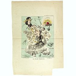
Le plan Trochu.
Lithography showing a map of France with a caricature of General Trochu and other scenes imposed on it. Designed by the French caricaturist Evrard, Emile , with his initi...
Date: Paris, 1871
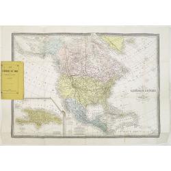
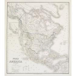
Nord-America
Large and detailed map of North and Central America. With inset key to the different possessions, Republic of Mexico, - Central America, States and territories.Lithograph...
- $150 / ≈ €130
Date: Berlin, 1872
Australien, von E. van Sÿdow.
Large School wall map of Australia and New Zealand, including some islands in the Pacific, including Hawaii. Prepared by Emil von Sydow (1812 - 1873), who was a Prussian ...
- $1000 / ≈ €865
Date: Gotha, H. Kiepert, 1873
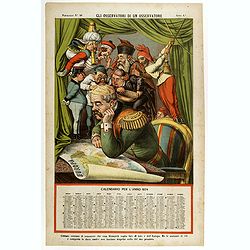
Gli observatori di un osservatore. Papagallo N°48.
Showing Bismarck studying a map of Europe. Taken from the Italian satirical newspaper "Il Papagallo", this plate N°48 has a descriptive text, in Italian langua...
- $600 / ≈ €519
Date: Bologne, 1873
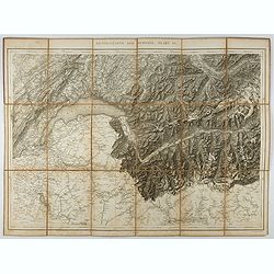
Generalkarte der Schweiz. Blatt III.
Folding map showing Leman lake. The map, engraved by Müllhaupt, is probably part of the 'Topographical Atlas of the Federal General Staff reduced under the direction of ...
- $75 / ≈ €65
Date: Bern, 1873
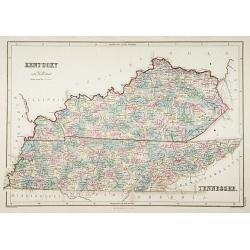
Kentucky.
A detailed lithographed map of Kentucky. Published by Adam (1784-1874) and Charles Black, publishers active in Edinburgh.
- $100 / ≈ €87
Date: Edinburg, 1874
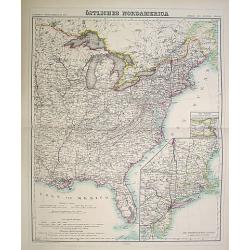
Östliches Nordamerica. . .
An extensive and detailed map of North America. With inset map lower right of "Die Nordöstlichen Staten". With color key in lower left.The map is prepared by H...
- $200 / ≈ €173
Date: Weimar 1874
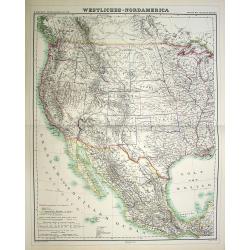
Westliches-Nordamerica.
An extensive and detailed map of North America. With color key in lower left. The map is prepared by H. Kiepert and published in Berlin by Dietrich Reimer and engraved b...
- $200 / ≈ €173
Date: Weimar, 1874
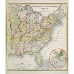
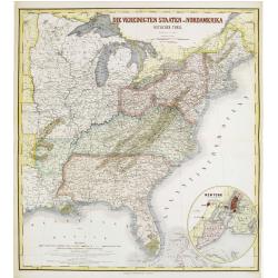
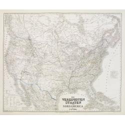
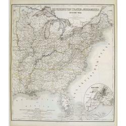
Die Vereinigten Staten von Nordamerika (Ostlicher theil).
Detailed map of eastern part of the United states. In lower right hand corner inset map of New York Bay, including, NY, Newark, Staten Island.The map is prepared by C.Gr�...
- $450 / ≈ €389
Date: Weimar, 1874
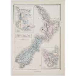
New Zealand.
A detailed lithographed map of New Zealand. With in upper left corner inset-map of Western Australia and in lower right hand corner a map of Van Diemens Land. Published b...
- $100 / ≈ €87
Date: Edinburg, 1874
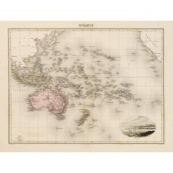
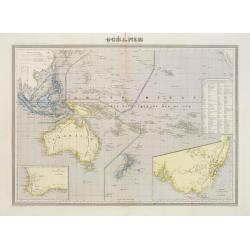
Océanie.
In lower right hand corner a view of Nouméa. Showing the Pacific including California. Engraved by L.Smith.
- $90 / ≈ €78
Date: Paris, 1874
Die Vereinigten Staten von Nordamerika (Ostlicher theil).
Detailed map of eastern part of the United states until the border of Texas. In lower right hand corner inset map of New York Bay, including, NY, Newark, Staten Island.Th...
- $450 / ≈ €389
Date: Weimar, 1874
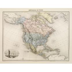
Amérique du Nord.
Decorative map of Northern America from Géographie Universelle, Atlas Migeon. published by J. Migeon. Nice engraving at the lower left hand of New York with the Statue o...
Date: Paris, 1874
Die Vereinigten Staten von Nordamerika nebst Canada.
Large and very detailed German map issued before the outbreak of the Civil War. It covers the United States, parts of Canada, and Mexico. The states and territories are s...
- $400 / ≈ €346
Date: Weimar, 1874
Nord America mit Westindien.
Detailed map of North America. With a color key indicating US, English, French, Dutch, Spanish, Portuguese, Danish possessions in the region with original outline color d...
- $300 / ≈ €260
Date: Weimar, 1874
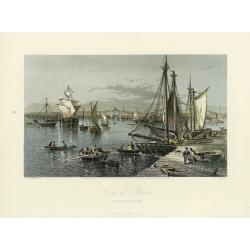
City of Boston.
A handsome mid 19th century panoramic view of the city of Boston as seen from the southern part of it's harbor. Many monuments are clearly visible, including the State Ho...
- $250 / ≈ €216
Date: New York, 1872-1874
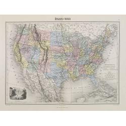
Etats-Unis.
Decorative map of the United States from Géographie Universelle, Atlas Migeon. Oklahoma is Indian Territory with Public Lands in the panhandle. With an engraving lower l...
- $75 / ≈ €65
Date: Paris, 1874
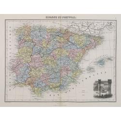
Espagne et Portugal.
A decorative map of Spain and Portugal from Géographie Universelle, Atlas Migeon. With an engraving of the Alhambra in the lower right corner. Published by J. Migeon. Fr...
- $35 / ≈ €30
Date: Paris, 1874
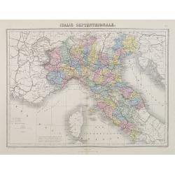
Italie Septentrionale.
A decorative map of northern Italy from Géographie Universelle, Atlas Migeon, published by J. Migeon.From one of the last decorative atlases published in the 19th centur...
- $25 / ≈ €22
Date: Paris, 1874
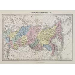
Sibérie ou Russie d'Asie.
A decorative map of Siberia from Géographie Universelle, Atlas Migeon. published by J. Migeon.From one of the last decorative atlases published in the 19th century.
Date: Paris, 1874
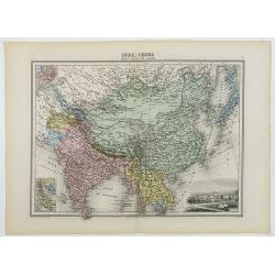
Inde, Chine, Indo-Chine et Japon.
A decorative map of India, China, Japan and East Asia from Géographie Universelle, Atlas Migeon, published by J. Migeon. In lower right corner a view of Calcutta and to ...
Date: Paris, 1874
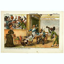
Un Posto mal fermo. Papagallo No. 5. Anno II.
Design by Augusto Grossi. Taken from the Italian satirical newspaper Il Papagallo, a satirical magazine founded in January 1873 by Augusto Grossi (1835-1919), which speci...
Date: Bologne, 1874
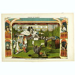
Theatre du Trianon. Papagallo No. 2. Anno II.
Design by Augusto Grossi. Taken from the Italian satirical newspaper Il Papagallo, a satirical magazine founded in January 1873 by Augusto Grossi (1835-1919), which speci...
Date: Bologne, 1874
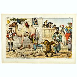
L'Orsa Balla. Papagallo No. 30. Anno II.
Design by Augusto Grossi. Taken from the Italian satirical newspaper Il Papagallo, a satirical magazine founded in January 1873 by Augusto Grossi (1835-1919), which speci...
Date: Bologne, 1874

I diritti da discutersi al congresso di Brusselle. Papagallo No. 32. Anno II.
Design by Augusto Grossi. Taken from the Italian satirical newspaper Il Papagallo, a satirical magazine founded in January 1873 by Augusto Grossi (1835-1919), which speci...
Date: Bologne, 1874
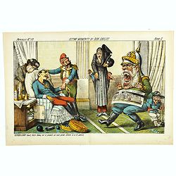
Ultimi momenti di Don Carlos. Papagallo No. 33. Anno II.
Design by Augusto Grossi. Taken from the Italian satirical newspaper Il Papagallo, a satirical magazine founded in January 1873 by Augusto Grossi (1835-1919), which speci...
Date: Bologne, 1874
Australie (Côte Est) Feuille N°10 Partie comprise entre La Baie Jervis et le Cap Everard . . .
Large French sea chart featuring the eastern coast of Australia. Engraved by J.Millian. The chart is based on surveys by the British Captn. F.W. Sidney, Staff Comr., H.J....
Date: Paris, 1874
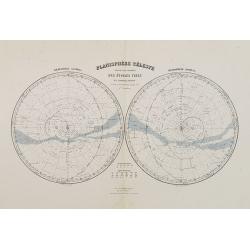
Planisphère Célèste.
Showing the southern and northern celestial hemispheres from Géographie Universelle, Atlas Migeon. Published by J. Migeon. From one of the last decorative atlases publis...
Date: Paris, 1874
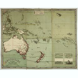
Océanie dresée par C.V.Monin.
Fine and uncommon map including Australia, New Zealand, Indonesia, with inset maps of New Zealand, Victoria/New South Wales and Western Australia including Albany and Per...
- $150 / ≈ €130
Date: Paris, 1875
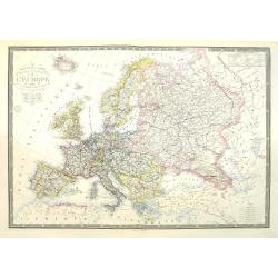
Nouvelle carte physique et politique de l'Europe. Les limites d'états.
A very large, uncommonly updated version of the map of Europe, prepared by H. Brué and updated by A. Vuillemin. In the lower margin, "Nouvelle edition" and a d...
Date: Paris, 1875
Nouvelle carte de l'Amérique Septentrionale et des iles qui en dépendent dressée par H. Brué. . .
Very large, highly detailed, and uncommon issue of the map of North and Central America (ca. 1:13,888,000) prepared by H. Brué and improved by A.Vuillemin. Showing main ...
- $500 / ≈ €433
Date: Paris, 1875
(Untitled map of western shores of the Black Sea, with Bulgaria, Roumenia.)
Untitled map of western shores of the Black Sea, with Bulgaria, Roumenia. The map has elaborate floral borders. Prepared by Josef Schlacher in Vienna and published by K.K...
- $150 / ≈ €130
Date: Vienna, K.K. Militär Geografisches Institut, 1875
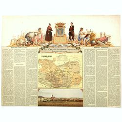
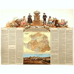
Provincia de Ciudad-Real.
Chromolithography published in "Atlas geográfico histórico de las Provincias de España". Map made by J. Reinoso, Dedicated to Excmo. Sr. Dn. Baldomero Espart...
- $120 / ≈ €104
Date: Madrid, c. 1875
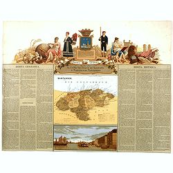
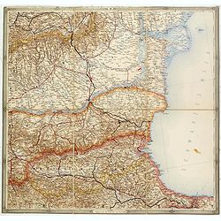
Provincia de Santander.
Chromolithography published in "Atlas geográfico histórico de las Provincias de España". Map engraved by J. Reinoso, Dedicated to Excmo. Sr. Duque de Santona...
- $120 / ≈ €104
Date: Madrid, c. 1875
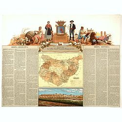
Provincia de Caceres.
Chromolithography published in "Atlas geográfico histórico de las Provincias de España". Map made by M. Vierge, Dedicated to Excmo. Sr. Dn. Cipriano Segundo ...
- $120 / ≈ €104
Date: Madrid, c. 1875
Provincia de Badajoz.
Chromolithography published in "Atlas geográfico histórico de las Provincias de España". Map engraved by M. Vierge, Dedicated to Ilmo. Sr. Dn. Vicente Barran...
- $120 / ≈ €104
Date: Madrid, c. 1875
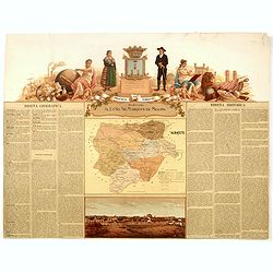
Provincia de Albacete.
Chromolithography published in "Atlas geográfico histórico de las Provincias de España". Map made by M. Vierge, Dedicated to Ilmo. Sr. Dn. Vicente Barrantes....
- $60 / ≈ €52
Date: Madrid, c. 1875
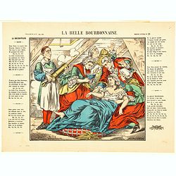
La Belle Bourbonnaise.
A lovely colorful lithograph illustration to accompany the song "The Beautiful Bourbonnaise". The lyrics to the song flank the print, which shows a woman bedrid...
Date: Paris ca 1875

Paris fashion plate. (164)
From Revue de la Mode. Gazette de la Famille.. Underneath the print are the names of the shops where the clothing's, perfumes, porcelains, flowers, etc., depicted in the ...
Date: Paris, 1875

Atlas der für den Weinbau Deutschlands und Oesterreichs werthvollsten Traubensorten. Mit genauer Beschreibung der Eigenschaften, Cultur-Methoden und des Schnittes...
Atlas der für den Weinbau Deutschlands und Oesterreichs werthvollsten Traubensorten. Mit genauer Beschreibung der Eigenschaften, Cultur-Methoden und des Schnittes, der A...
Date: Vienne, Wien, Faesy und Frick, 1873-1876
Die Vereinigten Staaten von Nordamerika (Ostlicher theil).
This is a 1876 example of C. Graf's map of the United States of America. The map covers the eastern part of the United States from eastern Texas to the Atlantic, extendin...
- $300 / ≈ €260
Date: Weimar, 1876