Browse Listings
![[Title page] Atlas général et élémentaire. . .](/uploads/cache/47732-250x250.jpg)
[Title page] Atlas général et élémentaire. . .
Decorative allegorical frontispiece page from "Atlas général et élémentaire", published by Louis Charles Desnos in 1778, with five text pages. Engraved by ...
- $200 / ≈ €173
Date: Paris, 1778
![The country Coromandel from the Coleroon to Cape Comorin. . . [with] The carnatic from the Pennar to the Coleroon. .](/uploads/cache/48363-250x250.jpg)
The country Coromandel from the Coleroon to Cape Comorin. . . [with] The carnatic from the Pennar to the Coleroon. .
Coromandel from the Coleroon to Cape Comorin. Elegant map in two sheets compiled for the East-India Company. In lower right margin : Writing by W. Harrison.
- $300 / ≈ €260
Date: London, 1778
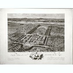
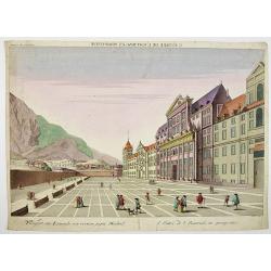
Plan perspective de l'École royale militaire.
A decorative bird's eye view of the complex of the French military school in Paris, 1777, showing all grounds and buildings of the 'Ecole Royale Militaire', drawn 'd'apr�...
- $250 / ≈ €216
Date: Paris, 1778
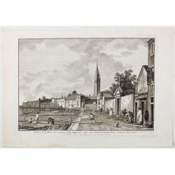
Ecclesae R.R.M.M. Ord. Servorum (vulgo Cappuccine) super ripam dictam Fondamente Nuove Prospectus litora versus.
Ecclesae [sic] R.R.M.M. Ord. Servorum (vulgo Cappuccine) super ripam dictam Fondamente Nuove Prospectus litora versus". Apud Ludovicum Furlanetto supra Pontem vulgo ...
Date: Venice, c. 1778
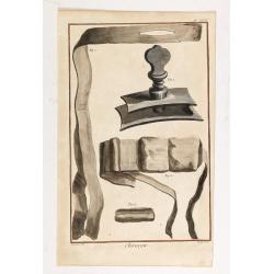
Chirurgie, plate XVIII
Showing bondage from the medical section of Diderot's Encyclopaedia. Engraved by Bernard after a design of Goussier. Very important work as it is giving an inventory of t...
- $100 / ≈ €87
Date: Paris 1779
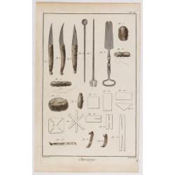
Chirurgie, plate II.
Showing medical instruments and bondage from the medical section of Diderot's Encyclopaedia. Engraved by Bernard after a design of Goussier. Very important work as it is ...
- $80 / ≈ €69
Date: Paris 1779

Chirurgie, plate XXXII
Showing medical bondage from the medical section of Diderot's Encyclopaedia. Engraved by Bernard after a design of Goussier. Very important work as it is giving an invent...
- $80 / ≈ €69
Date: Paris 1779
Carte du Mexique et de la Nouvelle Espagne..
Santini's version of D'Anville's important map shows the south-eastern part of the United States, Mexico and the Gulf of Mexico. Tecas is named as Nouv'le Leon. La Salle'...
Date: Venice 1779
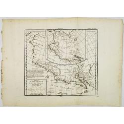
Carte de la Californie et des Pays Nord-Ouest. . . 4de Carte.
Diderot's famous 2 on 1 map shows the two early mappings of the west coast of North America, the first after Visscher, the second after Plancius' World map. Both show the...
- $200 / ≈ €173
Date: Paris, 1779
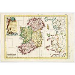
L'Irlande. . .
Map of Ireland, prepared by M. Philippe, embellished with a decorative title cartouche. Engraved by Vallet.
- $300 / ≈ €260
Date: Paris, 1779
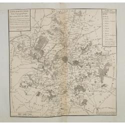
Carte particuliere semi-topographique de l'election de Paris. . .
Very decorative maps. Maps of the Parisian region. Map including Luzarches, Orgeval, Arpajon, Bussy saint georges.
- $300 / ≈ €260
Date: Paris 1779
![[Title page] Recueil de tous les Costumes.](/uploads/cache/06437-250x250.jpg)
[Title page] Recueil de tous les Costumes.
Uncommon and decorative title page of a man holding a curtain with title and a woman reading a book. With a dedication to Mr. Bignon, who was librarian of the King of Fra...
- $200 / ≈ €173
Date: Paris, 1779
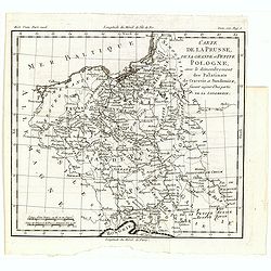
Carte de la Prusse, de la Grande et Petite Pologne, avec le démembrement des Palatinats de Cracovie et Sandomirz, faisant aujour d'hui partie de la Lodomerie.
A map of the Polish territories by Louis Brion de la Tour, from the work "Histoire universelle depuis le commencement du monde jusqu a present" published in Par...
Date: Paris, 1779
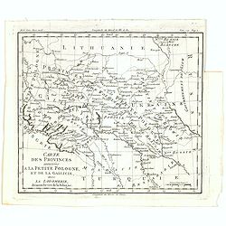
Carte des provinces annexées à la petite Pologne, et de la Gallicie, avec la Lodomerie, démembrées de la Pologne.
A map of the southern provinces of Poland by Louis Brion de la Tour, from the work "Histoire universelle depuis le commencement du monde jusqu a present" publis...
Date: Paris, 1779
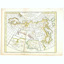
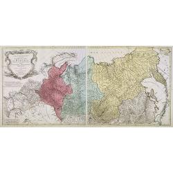
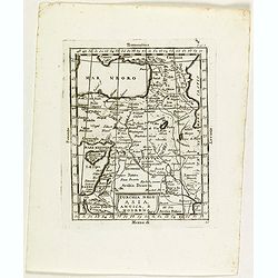
Carte des parties Nord et Est de L'Asie. . .
Five maps on one sheet, showing the Northern Russian territories in Europe and Asia, including the western coastline from Siberia, with Japan and Korea with the island of...
- $100 / ≈ €87
Date: Paris, 1779

Chirurgie, plate XIV.
Showing medical bondage from the medical section of Diderot's Encyclopedia. Engraved by Bernard after a design of Goussier. Very important work as it is giving an invento...
- $50 / ≈ €43
Date: Paris, 1779
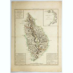
L'Isle de la Dominique par M.J.M.Anglois. . .
A handsome map of the Caribbean island of Dominica. There are "Observations" at lower left, and "Suite des observations" at lower right, both providin...
Date: Paris, 1779
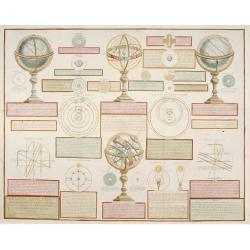
Analytique des différentes positions de la Sphère, des différens systemes, des révolutions et des distances des Planètes, &c
Containing "Globe Celeste", "Sphere de Copernic", "Globe Terrestre", "Systeme de Ptolomee" ; including diagrams of the solar syste...
Date: Paris, 1780
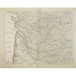
Carte du Bourdelois du Perigord et des provinces voisines..
Map covering the area from La Rochelle till the surrounding country of Bordeaux to the south and till Limoges and Cahors to the east.
- $120 / ≈ €104
Date: Paris, c. 1780
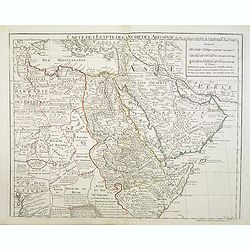
Carte de l'Egypte de la Nubie de l'Abissinie..
Map of east Africa showing South Arabia.
- $200 / ≈ €173
Date: Paris, 1780
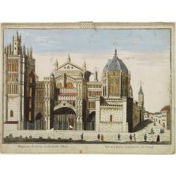
Vüe de L'Eglise Cathedrale de Tolede.
A so-optical print of a church in Toledo, Spain, prepared for use in a light-box or an amusing light-show. This richly hand colored print is much perforated, windows are ...
Date: Italy ca 1780
Carte géographique contenant le royaume de Sibérie . . .
Scarce and highly detailed map of Siberia subdivided into three provinces, namely Tobolsk, Jenissejesk, Irkutsk, and outer parts of the Tartary.In upper right corner inse...
Date: Augsburg, c. 1770-1780
Prospect des Escurials von vornen gegen Madrid / L'entrée de l'Escurial, en perspective.
A so-called optical print of the the entrance to the Escurial at the foot of the Sierra Guadarrama in Spain. Bilingual title in German and French. Engraved by Leizel.
Date: Augsburg, 1780
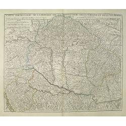
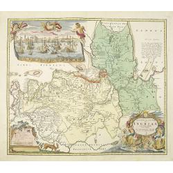
Carte Particuliere de la Hongrie de la Transilvanie de la Croatie et de la Sclavonie Dressée sur les Onservations de Mr. Le Comte Marsilli. . . Par G. Delisle.
Map of Hungary and Slovakia and adjacent parts of Croatia, Serbia and Romania (Transylvania). Prepared by Marsilli, published by Dezauche.
Date: Paris, ca. 1780
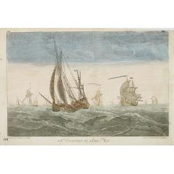
108e. Vaisseaux en pleine Mer.
Optical print of ships in the open sea, by Daumont, who was a well-known publisher of optical prints, established in Paris.In the eighteenth and nineteenth centuries, the...
- $200 / ≈ €173
Date: Paris, 1780
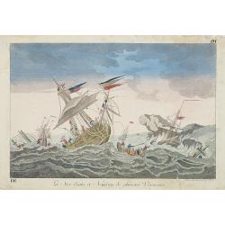
La Mer Agitée et Naufrage de plusietrs Vassseaux.
So-called optical print illustrating a dramatic rough sea with the wrecking of 3 ships.A so-called optical print by Daumont. In the eighteenth and nineteenth centuries, m...
- $200 / ≈ €173
Date: Paris, 1780
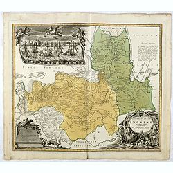
Ingermanlandiae seu Ingriae novissima tabula luci tradita. . .
Detailed map centered on Saint Petersburg. With imposing title cartouche and panoramic view of Saint Petersburg. The map was drawn shortly after the conclusion of the Gre...
Date: Nurenberg, 1780
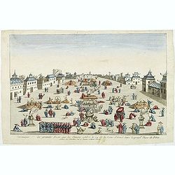
Ceremonie de la grande Feste que les Chinois celebre le 24 de la Lune d'Aoust dans la principale Place de Pekin.
So-called optical print illustrating the festivities on the 24th of August in Beijing.Mondhare was a well-known publisher of optical prints, established in Paris, at rue ...
Date: Paris, c.1780
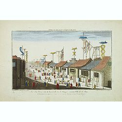
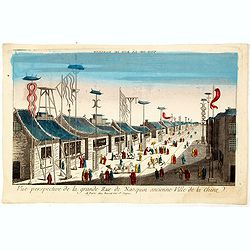
Vue perspective de la grande Rue de Nanquin ancienne Ville de la Chine.
So-called optical print of a street in Nanking. The wide boulevard is lined with merchants displaying their wares with colorful flags and signs. The street is filled with...
Date: Paris, c.1780
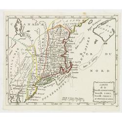
Carte de la Nouvelle Angleterre, Nouvelle York, Nouvelle Jersey, et Pensilvanie.
Highly detailed regional map of the Northeastern US, featuring numerous place names, Forts, Native American tribes, rivers,coastal banks, and other details. This is a Fre...
- $250 / ≈ €216
Date: Paris, 1780
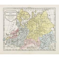
Partie Septentrionale de la Russie Européenne . . .
Detailed map of European part of Russia, including Finland and Lapland.
Date: Paris, 1780
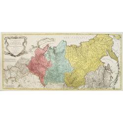
Carte géographique contenant le Royaume de Siberie . . .
Very rare and highly detailed map of Siberia subdivided in three provinces, namely Tobolsk, Jenissejesk, Irkutsk, and outer parts of the Tartary. In upper right corner in...
- $800 / ≈ €692
Date: Augsburg, 1770- 1780
![Fille Jakoute par derrière [together with] Fille Jakoute par devant.](/uploads/cache/32984-250x250.jpg)
Fille Jakoute par derrière [together with] Fille Jakoute par devant.
Uncommon copper-engraved costume plate from Johann Gottlieb Georgi "Beschreibung aller Nationen des russischen Reichs" (1776), the work stands out for the hand-...
- $75 / ≈ €65
Date: St. Petersbourg, C.G. Müller, 1776-1780
![Fille Jakoute par derrière [together with] Fille Jakoute par devant.](/uploads/cache/32985-250x250.jpg)
Fille Jakoute par derrière [together with] Fille Jakoute par devant.
Uncommon copper-engraved costume plate from Johann Gottlieb Georgi "Beschreibung aller Nationen des russischen Reichs" (1776), the work stands out for the hand-...
- $75 / ≈ €65
Date: St. Petersbourg, C.G. Müller, 1776-1780
![Un Jacout en habit de chasse par devant [together with] Un Jakout en habit de chasse par derriére.](/uploads/cache/32986-250x250.jpg)
Un Jacout en habit de chasse par devant [together with] Un Jakout en habit de chasse par derriére.
Uncommon copper-engraved costume plate from Johann Gottlieb Georgi "Beschreibung aller Nationen des russischen Reichs" (1776), the work stands out for the hand-...
- $75 / ≈ €65
Date: St. Petersbourg, C.G. Müller, 1776-1780
![Fille tatare à Kousnetsk par devant. [together with] Fille tatare Kousnetsk par derriere.](/uploads/cache/32988-250x250.jpg)
Fille tatare à Kousnetsk par devant. [together with] Fille tatare Kousnetsk par derriere.
Uncommon copper-engraved costume plate from Johann Gottlieb Georgi "Beschreibung aller Nationen des russischen Reichs" (1776), the work stands out for the hand-...
- $75 / ≈ €65
Date: St. Petersbourg, C.G. Müller, 1776-1780
![Femme tatare à Kousnetsk par devant. [together with] Femme tatare à Kousnetsk par derriere.](/uploads/cache/32990-250x250.jpg)
Femme tatare à Kousnetsk par devant. [together with] Femme tatare à Kousnetsk par derriere.
Uncommon copper-engraved costume plate from Johann Gottlieb Georgi "Beschreibung aller Nationen des russischen Reichs" (1776), the work stands out for the hand-...
- $75 / ≈ €65
Date: St. Petersbourg, C.G. Müller, 1776-1780
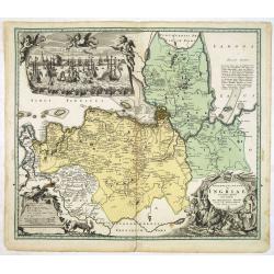
Ingermanlandiae seu Ingriae. . .
Detailed map centered on St.Petersburg. With imposing title cartouche and panoramic town-view of St.Petersburg. The map was drawn shortly after the conclusion of the Grea...
- $750 / ≈ €649
Date: Nurenberg, 1780
Vue perspective de la grande Rue de Nanquin ancienne Ville de la Chine.
So-called optical print of a street in Nanking. The wide boulevard is lined with merchants displaying their wares with colorful flags and signs. The street is filled with...
Date: Paris, c.1780

Kirgise à cheval.
Uncommon copper-engraved costume plate from Johann Gottlieb Georgi "Beschreibung aller Nationen des russischen Reichs" (1776), the work stands out for the hand-...
- $50 / ≈ €43
Date: St. Petersbourg, C.G. Müller, 1776-1780

Femme tatare de Katchin.
Uncommon copper-engraved costume plate from Johann Gottlieb Georgi "Beschreibung aller Nationen des russischen Reichs" (1776), the work stands out for the hand-...
- $50 / ≈ €43
Date: St. Petersbourg, C.G. Müller, 1776-1780
![Une Chamane ou devineresse de Krasnojarsk par derrière.[together with] Une Chamane ou devineresse de Krasnojarsk.](/uploads/cache/33007-250x250.jpg)
Une Chamane ou devineresse de Krasnojarsk par derrière.[together with] Une Chamane ou devineresse de Krasnojarsk.
Uncommon copper engraved costume plate from Johann Gottlieb Georgi "Beschreibung aller Nationen des russischen Reichs" (1776), the work stands out for the hand-...
- $100 / ≈ €87
Date: St. Petersbourg, C.G. Müller, 1776-1780
Tempum S.Joannis in Laterano Romae. . .
A so-called optical print. In the eighteenth and nineteenth centuries there were many popular specialty establishments in Paris, Augsburg and London which produced optica...
- $150 / ≈ €130
Date: Italy, ca.1780
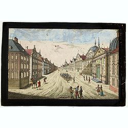
Prospect der Strasse gegen der Kirche der Recolecten in der obern Stadt zu Quebec. Vuë de la Rue des Recolets dans la haute Ville de Quebec.
A so-called optical print showing a decorative imaginary town view of Québec, with a street view with soldiers marching and pedestrians, an idealized view depicting Qué...
- $450 / ≈ €389
Date: Augsburg, ca. 1780
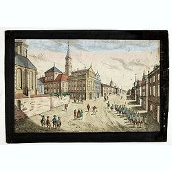
Prospect des Haupt Plazes der Untern Stadt zu Quebec.
A so-called optical print showing a decorative imaginary town view of Québec, with a street view with soldiers marching and pedestrians, an idealized view depicting Qué...
- $500 / ≈ €433
Date: Augsburg, ca.1780
Ingermanlandiae seu Ingriae novissima tabula luci tradita. . .
Detailed map centered on St. Petersburg. With imposing title cartouche and panoramic view of St. Petersburg. The map was drawn shortly after the conclusion of the Great N...
Date: Nurenberg, 1780
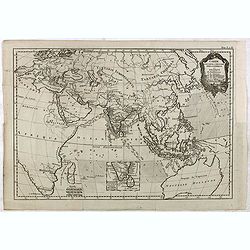
Carte pour servir a L'Histoire Philosophique et Politique..
Showing the eastern hemisphere, including Australia. With inset map of India and Sri Lanka in the Indian Ocean.The focus of the chart is European trade and commerce with ...
- $150 / ≈ €130
Date: Paris, 1780
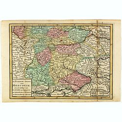
T Zuider-Deel van Moscovie.
Map details the regions South from Moscow to the Black Sea and the Sea of Azof.
- $150 / ≈ €130
Date: Deventer, ca 1780
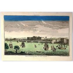
Vue de la Pondichery dans les Indes Orientales
Pondicherry is the capital city of Indian union territory of Puducherry. Pondicherry is situated in Puducherry district of the union territory in India. The vue was produ...
Date: Paris, 1780
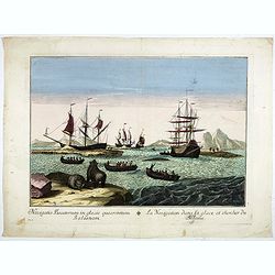
Navigatio Piscatorum in glacie quaerentium Balaenam / La navigation dans la glace, et chercher du Baleine.
A so called optical print of the Greenland Whale Fishery with polar bears in foreground. Bilingual title in Latin and French.
- $400 / ≈ €346
Date: Italy, c. 1780
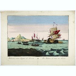
Balaena ramis adigitur ad Navim / La baleine est rame en Navire.
A so called optical print of the Greenland Whale Fishery with polar bears in foreground. Bilingual title in Latin and French.
- $400 / ≈ €346
Date: Italy, c. 1780
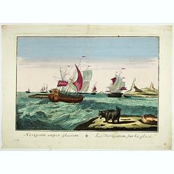
Navigacio super Glaciem / La navigation sur la glace.
A so called optical print of the Greenland Whale Fishery with polar bears in foreground. Bilingual title in Latin and French.
- $400 / ≈ €346
Date: Italy, c. 1780
Carte topographique d'Allemagne contenant une partie du royaume de Boheme. . .
Detailed map cantered on Prague, Caaden, Laim, Melnik… Map 43 of the multi sheet map "Carte topographique d'Allemagne" of German Empire. Published by Johann W...
- $100 / ≈ €87
Date: Frankfurt, ca.1780
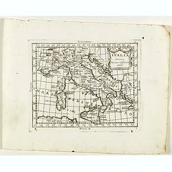
Italia divisa né suoi differenti stati.
Rare map of Italy, Sardinia and Corsica from "Atlante Novissimo ad uso Dei Giovani Studiosi Contenuto In Carte XXVII.", published by Giovanni Zempel in Rome, ca...
- $50 / ≈ €43
Date: Rome, 1780
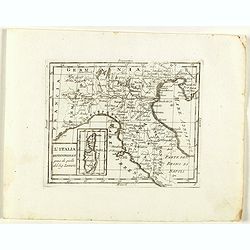
L'Italia Settentrionale presa da quella del Sig. Zannoni.
Rare map of Italy with inset map with Corsica and Sardinia, from "Atlante Novissimo ad uso Dei Giovani Studiosi Contenuto In Carte XXVII.", published by Giovann...
- $75 / ≈ €65
Date: Rome, 1780
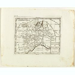
Parte Occidentale del Regno Italico, Il Piemonte e Genovestato.
Rare map of Piemonte region in Italy, centered on Piemonte region, Genova and Milan, from "Atlante Novissimo ad uso Dei Giovani Studiosi Contenuto In Carte XXVII.&qu...
- $75 / ≈ €65
Date: Rome, 1780
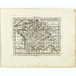
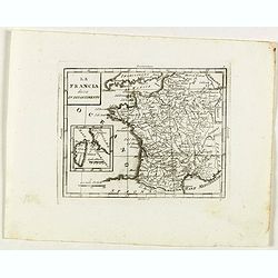
Francia divisa in provincie.
Rare map of France, from "Atlante Novissimo ad uso Dei Giovani Studiosi Contenuto In Carte XXVII.", published by Giovanni Zempel in Rome, ca. 1780.The map is ba...
- $50 / ≈ €43
Date: Rome, 1780
La Francia divisa in dipartimenti.
Rare map of South western France and inset with map of Corsica, from "Atlante Novissimo ad uso Dei Giovani Studiosi Contenuto In Carte XXVII.", published by Gio...
- $40 / ≈ €35
Date: Rome, 1780
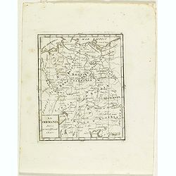
La Germania divisa ne' suoi differenti stati
Rare map of Germany, from "Atlante Novissimo ad uso Dei Giovani Studiosi Contenuto In Carte XXVII.", published by Giovanni Zempel in Rome, ca. 1780.The map is b...
- $25 / ≈ €22
Date: Rome, 1780
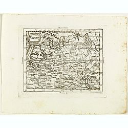
Moscovia.
Rare map of western Russia centered on Moscow, from "Atlante Novissimo ad uso Dei Giovani Studiosi Contenuto In Carte XXVII.", published by Giovanni Zempel in R...
- $100 / ≈ €87
Date: Rome, 1780
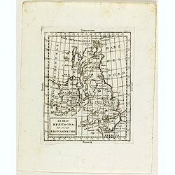
La Gran Bretagna ed isole Britanniche.
Rare map of Great Britain with Ireland, from "Atlante Novissimo ad uso Dei Giovani Studiosi Contenuto In Carte XXVII.", published by Giovanni Zempel in Rome, ca...
- $75 / ≈ €65
Date: Rome, 1780
Turchia Nell' Asia antica, e moderna.
Rare map of Armenia, Palestine, Turkey and northern Arabia, from "Atlante Novissimo ad uso Dei Giovani Studiosi Contenuto In Carte XXVII.", published by Giovann...
- $200 / ≈ €173
Date: Rome, 1780
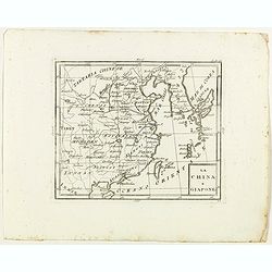
La China e Giapone.
Rare map of China, Korea and Japan, from "Atlante Novissimo ad uso Dei Giovani Studiosi Contenuto In Carte XXVII.", published by Giovanni Zempel in Rome, ca. 17...
- $300 / ≈ €260
Date: Rome, 1780
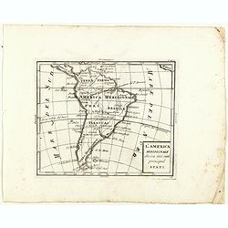
L'America meridionale divisa nei suoi principali stati.
Rare map of south America, from "Atlante Novissimo ad uso Dei Giovani Studiosi Contenuto In Carte XXVII.", published by Giovanni Zempel in Rome, ca. 1780.The ma...
- $100 / ≈ €87
Date: Rome, 1780
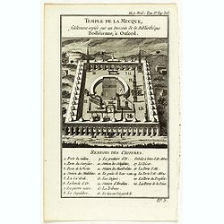
Temple de la Mecque fidelement copiée sur un dessein de la bibliothèque Bodléienne, à Oxford.
View of the Mecca Temple.
Date: Pqris, ca. 1780
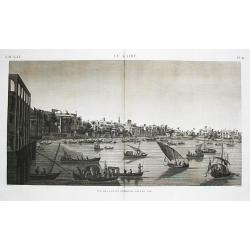
Le Kaire (Cairo). Vue de la place Ezbekyeh, côté du sud
A very fine view of Cairo.
- $500 / ≈ €433
Date: Paris, ca 1780
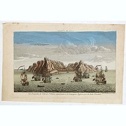
Vue perpective de l'Isle de St.Helene appartenant a la Compagnie Angloise pour les Indes Orientales.
Decorative optical view of St. Helena. The island is well-known as after the Royal Navy captured Napoleon Bonaparte, he was held hostage on the island until he died in 18...
- $300 / ≈ €260
Date: Paris, 1780

Vue Perspective de la Place des Victoires
So-called optical print of la Place des Victoires in Paris. Therefore the image is reversed or mirror-image. One of the well-known publishers of optical prints, establish...
- $100 / ≈ €87
Date: Paris, 1780
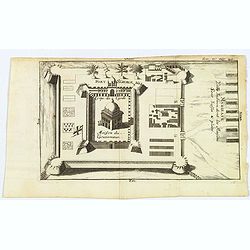
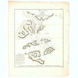
Madirass. Ville Indienne don't les Maisons sont basses & plates.
A small plan of Fort St. George, Madras/Chennai in India. It highlights both inner and outer fortifications, fences, town entrances and the sea, together with the church,...
Date: Unknown, ca 1780
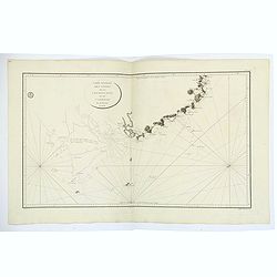
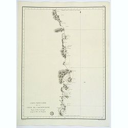
Carte Generale des Cotes de la Cochinchine et du Camboge.
A large, double-page French sea chart of part of the southern Cambodian coastline, and from Vietnamese Saigon up to Vung-Tau, Cap Varella, Cam Ranh Bay and Nha Trang. Wit...
Date: Paris, 1780
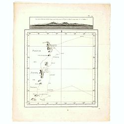
Carte Particuliere de la Cote de Cochinchine Depuis la baie Camraigne jusqu'a le baie de Tamquam.
A basic coastal sea chart of a part of French Indochina (Vietnam) from Cap Varella and Cam Ranh Bay in the south, northward past Nha Trang, Hen Kohe Bay, on to Phu-yen Ba...
Date: Paris ca 1780
![[No Title]](/uploads/cache/46548-250x250.jpg)
[No Title]
A small copperplate engraving showing an elderly lady sitting in her bed chamber, astride a camode , using a cylster, probably to administer an enema to herself. A not un...
Date: France, ca. 1780
Plan du Typa, ou de Macao.
A pleasant copper engraving of Typa, Macao. By Rigobert Bonne from his ATLAS ENCYCLOPEDIQUE published in 1780. Engraved by Andre.Rigobert Bonne (1727-1795) was one of the...
- $100 / ≈ €87
Date: Paris, 1780
Vue de la Côte du Japon lorsque nous la vimespour la 1ere fois La Coline A restant dans l'O à 3 Millerc.
A pleasant copper engraving of Japan coasts. By Rigobert Bonne from his ATLAS ENCYCLOPEDIQUE published in 1780. Engraved by Andre.Rigobert Bonne (1727-1795) was one of th...
- $100 / ≈ €87
Date: Paris, 1780
![[Title page] Atlas Géographique des quatre parties du monde . . .](/uploads/cache/47734-250x250.jpg)
[Title page] Atlas Géographique des quatre parties du monde . . .
Title page of Atlas Géographique des quatre parties du monde by Guillaume De L'Isle and Philippe Buache, published by Jean-Claude Dezauche ca. 1820. With two catalog pag...
- $350 / ≈ €303
Date: Paris, ca. 1780
![["Kijkkast"]. Viewing box for optical prints](/uploads/cache/49106-250x250.jpg)
["Kijkkast"]. Viewing box for optical prints
A very rare custom made collapsible peepshow in a bookshaped box, late 18th century, folded out 66(h.)x56(w.)x40(d.) cm., 7 hinging cardboard parts painted blue or w. bla...
- $12000 / ≈ €10385
Date: The Netherlands, ca. 1780
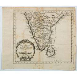
Carta Dell' Indostan che comprende il Malabar, Coromandel, e tutta la penisola Dell' India.
This is from a scarce Italian edition of French cartographer Jacques-Nicholas Bellin’s map of southern India and the island of Ceylon (Sri Lanka). The map extent is fro...
Date: Paris, ca 1780
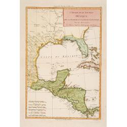
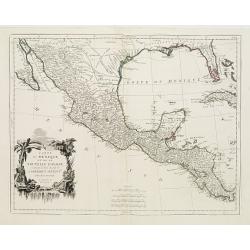
L'Ancien et le nouveau Mexique avec la Floride..
Covering Florida, Texas, western part of Cuba and central America. Showing dozens (100+) of place names, extensive river systems, mountain ranges and featuring the Gulf o...
Date: Paris, 1781
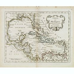
Golfe du Mexique Assujetti aux Observations Astronomiques Par J.B.Nolin.
Rare map of the Caribbean prepared by J.B.Nolin and published by L.J. Mondhare for his Atlas Général a l'usage des colleges et maisons d'education.. Louis Joseph Mondha...
- $200 / ≈ €173
Date: Paris, 1781
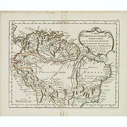
Carte du Bresil le Perou. . .
Scarce map of Northern part of South America with Venezuela, Colombia, Brazil and Peru, prepared by Nolin and published by L.J. Mondhare for his Atlas Général a l'usage...
- $125 / ≈ €108
Date: Paris, 1781