Browse Listings
Malte.
A charming late 17th century French plan of La Valletta. With a ribbon style title cartouche and a nautical sailing ship scene across the top.By Allain Manneson Mallet (1...
- $225 / ≈ €195
Date: Paris, 1683
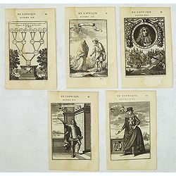
Set of 5 Malta related copper engravings.
Set of 5 Malta-related copper engravings from the French edition of the "Description De L'Univers" by Allain Manesson Mallet. French edition, 1683..By Allain Ma...
- $200 / ≈ €173
Date: Paris, 1683
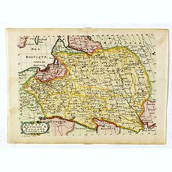
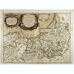
Estats de la Couronne de Pologne.
Map of Poland prepared by N.Sanson and published by F. Halma.Published in an Dutch edition of the small Sanson atlas L'Europe Dediée a Monseigneur . . . Le Tellier Secre...
Date: Amsterdam, Utrecht, 1683
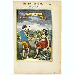
P.les du Chile.
A charming copper engraving depicting a town surrounded by a luxuriant landscape on the background and a couple of indigenous on the foreground.From the French text editi...
- $60 / ≈ €52
Date: Paris, 1683
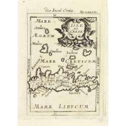
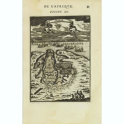
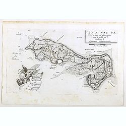
Isle de Crete.
A charming late 17th century map of the Island of Crete. By Allain Manneson Mallet (1630-1706), a well traveled military engineer and geographer who worked in 17th centur...
Date: Frankfurt, 1684
![Fig. 2. [ print depicting three armillary spheres]](/uploads/cache/22626-250x250.jpg)
Fig. 2. [ print depicting three armillary spheres]
Appealing print depicting three armillary spheres.From the German text edition of Description d'Univers.. (5 volumes), 1683. By Allain Manneson Mallet (1630-1706), a well...
- $150 / ≈ €130
Date: Frankfurt, 1684
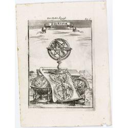
Equateur.
Appealing print centered on an armillary sphere. The latter sits atop a map of the world, which clearly shows California as an island (in reverse — the engraver must ha...
- $125 / ≈ €108
Date: Frankfurt, 1684

Pas kaart Van Rio Oronoque Golfo De Paria met d'Eylanden Trinidad, Tabago, Granada, Granadillos, en Bequia . . .
A highly detailed and rare sea chart of the mouth of the Orinoco River, Trinidad, Tabago, St.Vincent and neighboring islands. Oriented with north to the right by two comp...
Date: Amsterdam, 1684
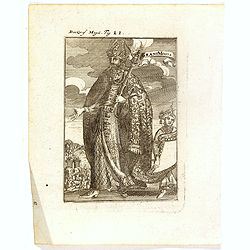
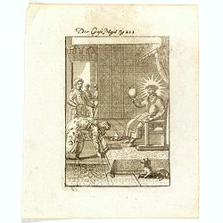
Grant Mogol - Der Graf Mogol (Fig LI).
A fine and uncommon early 17th century print of a Mughal emperor. Engraved by Joh. Jak. Vogel.By Allain Manneson Mallet (1630-1706), a well traveled military engineer and...
- $45 / ≈ €39
Date: Frankfurt, 1684

Die Mogoler (Fig LIII).
A fine and uncommon early 17th century print of a couple at time of the Mughal Empire. Engraved by Joh. Jak. Vogel.By Allain Manneson Mallet (1630-1706), a well traveled ...
- $40 / ≈ €35
Date: Frankfurt, 1684
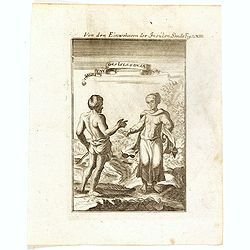
Von den Einwohnerne der Insulen Sonde (Fig LXIII).
A fine and uncommon early 17th century print of two inhabitants of the Sunda Islands, East Indies (Indonesia). Engraved by Joh. Jak. Vogel.By Allain Manneson Mallet (1630...
- $75 / ≈ €65
Date: Frankfurt, 1684
Der Grosse Mogol Fig LII.
A fine and uncommon early 17th century print of a Mogol.By Allain Manneson Mallet (1630-1706), a well traveled military engineer and geographer who worked in 17th century...
- $45 / ≈ €39
Date: Frankfurt, 1684
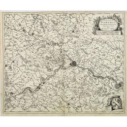
Comitatus Namurci Emendata Delineatio, Nuperrimè in lucem edita, per Nicolaum Visscher.
Detailed engraved map of the province of Namur (Namen), showing cities including Charleroi and Dinant., towns, rivers and lakes. Decorative cartouche with putti. Explanat...
Date: Amsterdam, 1684
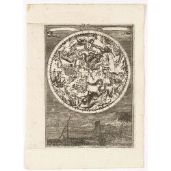
(Celestial) Fig. 36.
A fine celestial map depicting the southern constellations in allegorical form. Fully engraved, it presents a landscape with some sailing ships in the background.From the...
- $200 / ≈ €173
Date: Frankfurt, 1684
S. Nicolaes.
Beautifully etched by Gasper Bouttats (1640-1695) of Szent-Nicolas (Madarsko). Published by Jacques Peeters.
- $150 / ≈ €130
Date: Antwerp, c. 1684
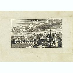
Adrianopel. (Edirne)
Panoramic view of Adrianopel or its modern name Edirne in European Turkey, near the border with Greece and Bulgaria. Published in "Der Donau-Strand Mit allen seinen ...
- $75 / ≈ €65
Date: Nuremberg, Jacob Sandrart, 1684
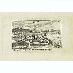
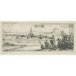
Sissek.
Panoramic view of Sisak in Sisak in central Croatia. Published in "Der Donau-Strand Mit allen seinen Ein- und Zuflüssen. . .". Published by Jacob Sandrart.
- $75 / ≈ €65
Date: Nuremberg, Jacob Sandrart, 1684
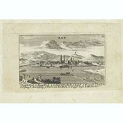
Rab. / Leopoldina. / Der Grosse und wunderbare Comet. . .
On recto panoramic view of Raab or Gyor, the Hungarian town on the Danube. On verso a plan of Leopoldina and a view of comet. Published in "Der Donau-Strand Mit alle...
- $90 / ≈ €78
Date: Nuremberg, Jacob Sandrart, 1684
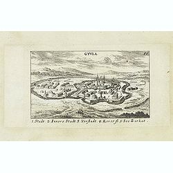
Gyula.
Panoramic view of Gyula in Békés County, Hungary. The town is best known for its Medieval castle and thermal bath. Published in "Der Donau-Strand Mit allen seinen ...
- $75 / ≈ €65
Date: Nuremberg, Jacob Sandrart, 1684
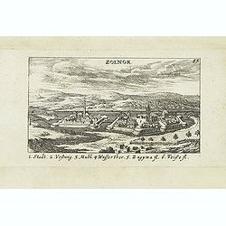
Zolnok.
Panoramic view of Szolnok (solnok) is the county seat of Jász-Nagykun-Szolnok county in central Hungary. Its location on the banks of the Tisza river, at the heart of th...
- $75 / ≈ €65
Date: Nuremberg, Jacob Sandrart, 1684
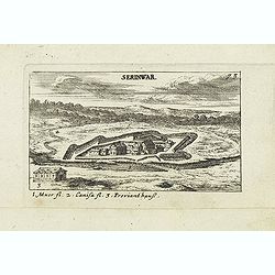
Serinwar. (Zrínyi vár)
Panoramic view of Zrínyi vár in Hungary. Published in "Der Donau-Strand Mit allen seinen Ein- und Zuflüssen. . .". Published by Jacob Sandrart.
- $90 / ≈ €78
Date: Nuremberg, Jacob Sandrart, 1684
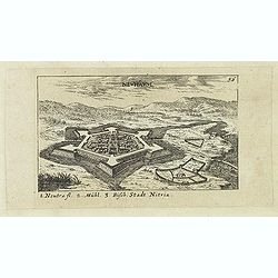
Neuhäusl. (Nové Zámky)
Panoramic view of Nové Zámky, in southwestern Slovakia.Published in "Der Donau-Strand Mit allen seinen Ein- und Zuflüssen. . .". Published by Jacob Sandrart.
- $75 / ≈ €65
Date: Nuremberg, Jacob Sandrart, 1684
![Weitzen [Vác / Waitzen]](/uploads/cache/30817-250x250.jpg)
Weitzen [Vác / Waitzen]
Panoramic view of Vác / Waitzen with the Donau in the foreground Published in "Der Donau-Strand Mit allen seinen Ein- und Zuflüssen. . .". Published by Jacob ...
- $90 / ≈ €78
Date: Nuremberg, Jacob Sandrart, 1684
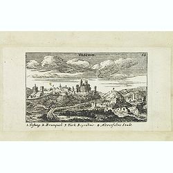
Vesprin.
Panoramic view of Veszprém is one of the oldest urban areas in Hungary, and a city with county rights. It lies approximately 15 km north of the Lake Balaton. Published i...
- $90 / ≈ €78
Date: Nuremberg, Jacob Sandrart, 1684
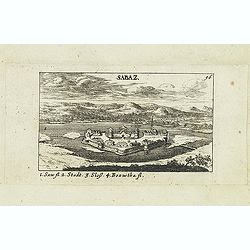
Sabaz. (Sabac)
View of Šabac in western Serbia, along the Sava river.Published in "Der Donau-Strand Mit allen seinen Ein- und Zuflüssen. . .". Published by Jacob Sandrart.
- $75 / ≈ €65
Date: Nuremberg, Jacob Sandrart, 1684
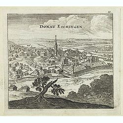
Donau Eschingen. / Der donaü stränd.
Two views pasted on recto and verso of a larger sheet of paper. On recto panoramic view of Donaueschingen a German town in the Black Forest.On verso a map of the Danube a...
- $75 / ≈ €65
Date: Nuremberg, Jacob Sandrart, 1684
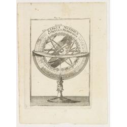
Fig. 4.
Appealing print focused on an armillary sphere.From the German text edition of Description d'Univers.. (5 volumes), 1683. By Allain Manneson Mallet (1630-1706), a well tr...
- $150 / ≈ €130
Date: Frankfurt, 1684
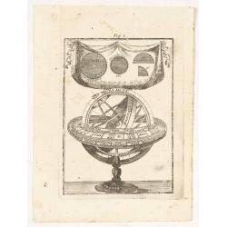
Fig. 3.
Appealing print depicting an armillary sphere.From the German text edition of Description d'Univers.. (5 volumes), 1683. By Allain Manneson Mallet (1630-1706), a well tra...
- $150 / ≈ €130
Date: Frankfurt 1684
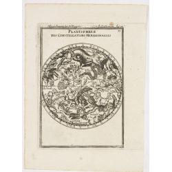
Planisphere des Constellations Meridionalles.
A fine celestial map depicting the southern constellations in allegorical form.From the German text edition of Description d'Univers.. (5 volumes), 1683. By Allain Maness...
- $200 / ≈ €173
Date: Frankfurt, 1684
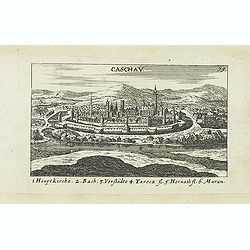
Caschav.
Panoramic view of Caschav (Cassovie). Published in "Der Donau-Strand Mit allen seinen Ein- und Zuflüssen. . .". Published by Jacob Sandrart.
- $100 / ≈ €87
Date: Nuremberg, Jacob Sandrart, 1684
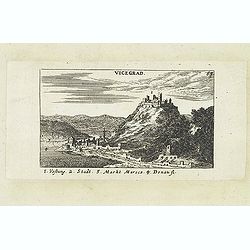
Vicegrad.
Panoramic view of Vicegrad. Published in "Der Donau-Strand Mit allen seinen Ein- und Zuflüssen. . .". Published by Jacob Sandrart.
- $100 / ≈ €87
Date: Nuremberg, Jacob Sandrart, 1684
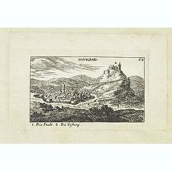
Novigrad.
Panoramic view of Nógrád in northern Hungary. Published in "Der Donau-Strand Mit allen seinen Ein- und Zuflüssen. . .". Published by Jacob Sandrart.
- $150 / ≈ €130
Date: Nuremberg, Jacob Sandrart, 1684
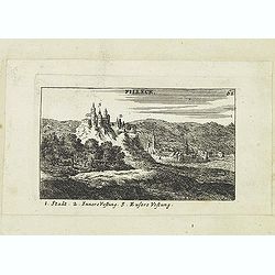
Filleck.
Panoramic view of Filleck (Fuleck, Filakovo). Published in "Der Donau-Strand Mit allen seinen Ein- und Zuflüssen. . .". Published by Jacob Sandrart.
- $150 / ≈ €130
Date: Nuremberg, Jacob Sandrart, 1684
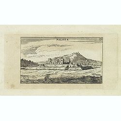
Palota.
Panoramic view of Palota in the Medzilaborce District in the Prešov Region of far north-eastern Slovakia. Published in "Der Donau-Strand Mit allen seinen Ein- und Z...
- $150 / ≈ €130
Date: Nuremberg, Jacob Sandrart, 1684
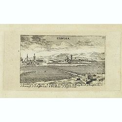
Comora.
Panoramic view of Comora. Published in "Der Donau-Strand Mit allen seinen Ein- und Zuflüssen. . .". Published by Jacob Sandrart.
- $100 / ≈ €87
Date: Nuremberg, Jacob Sandrart, 1684
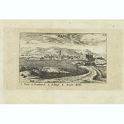
Papa.
Panoramic view of historical city Papa. Published in "Der Donau-Strand Mit allen seinen Ein- und Zuflüssen. . .". Published by Jacob Sandrart.
- $100 / ≈ €87
Date: Nuremberg, Jacob Sandrart, 1684
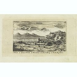
Dotis.
Panoramic view of Dotis (Tata). Published in "Der Donau-Strand Mit allen seinen Ein- und Zuflüssen. . .". Published by Jacob Sandrart.
- $150 / ≈ €130
Date: Nuremberg, Jacob Sandrart, 1684
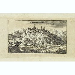
S. Martinsberg.
Panoramic view of S. Martinsberg. Published in "Der Donau-Strand Mit allen seinen Ein- und Zuflüssen. . .". Published by Jacob Sandrart.
- $100 / ≈ €87
Date: Nuremberg, Jacob Sandrart, 1684
Stulweissenburg. (Székesfehérvár)
Panoramic view of Székesfehérvár. Published in "Der Donau-Strand Mit allen seinen Ein- und Zuflüssen. . .". Published by Jacob Sandrart.
- $100 / ≈ €87
Date: Nuremberg, Jacob Sandrart, 1684
![Erla [Eger]](/uploads/cache/30834-250x250.jpg)
Erla [Eger]
Panoramic view of Eger. Published in "Der Donau-Strand Mit allen seinen Ein- und Zuflüssen. . .". Published by Jacob Sandrart.
- $150 / ≈ €130
Date: Nuremberg, Jacob Sandrart, 1684
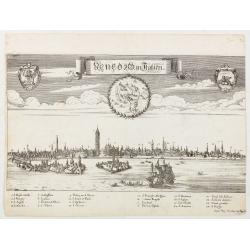
Venedig in Italien.
View of Venice with a numbered key 1-24. Lower right below the legend " Iohan Philip Steüdner ex Augusta". From "Theatrum Adriaticum, oder Schau-Platz de�...
Date: Augsburg, 1685
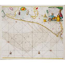
Nieuwe Paskaert van de Kust van HOLLANDT - Tussen Texel en de Maes.
Nieuwe Paskaert van de Kust van Hollandt Tussen Texel en de Maes. A very attractive sea chart off the coast of Holland by Johannes van Keulen with a pair of decorative c...
- $500 / ≈ €433
Date: Amsterdam, ca 1685
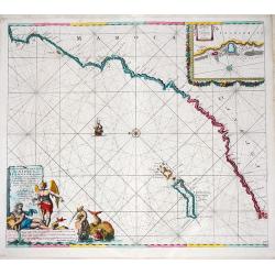
Nieuwe Pascaert van de Kust van Maroca en Zanhaga. . .
A very fine sea chart of the west coast of Morocco between C.Cantin tot C.Bajador and the Canary Islands, Lanzerote and Fuerteventura. With a very large decorative title-...
Date: Amsterdam, ca 1685
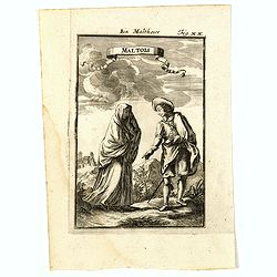
Maltois. Ein Maltheser Fig. XX.
Charming late 17th century engraving of a couple in local dress from Malta.By Allain Manneson Mallet (1630-1706), a well traveled military engineer and geographer who wor...
- $120 / ≈ €104
Date: Frankfurt, 1685

GM de Malte. Der Grossmeister von Malta Fig. XVIII.
Charming late 17th century engraving of grand master of Malta.By Allain Manneson Mallet (1630-1706), a well traveled military engineer and geographer who worked in 17th c...
- $120 / ≈ €104
Date: Frankfurt, 1685
![Ancien Cheva.er de Malte Ein Alter Malthese Ritter Fig: XVI [Together with] D. Gregoire Caraffe G.M. de Malte MDCLXXXI.](/uploads/cache/35860-250x250.jpg)
Ancien Cheva.er de Malte Ein Alter Malthese Ritter Fig: XVI [Together with] D. Gregoire Caraffe G.M. de Malte MDCLXXXI.
Two charming late 17th century engravings of an Knight of Malta and an round portrait of Gregoire Carafa.The copper plate seems during the printing process not well clean...
- $120 / ≈ €104
Date: Frankfurt, 1685
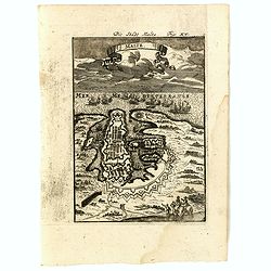
Malte Die Stadt Malta Fig: XV.
A charming late 17th century birds-eye view of Valletta and its fortifications from the southeast with battle ships in the sea. Title scroll in the sky.The copper plate s...
- $250 / ≈ €216
Date: Franckfurt, 1685
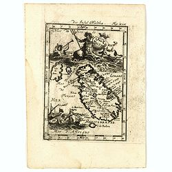
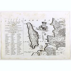
Isle de Malthe. Die Insul Maltha Fig: XIV.
A charming late 17th century map of Malta and Gozo with a large pictorial cartouche depicting Neptune and a merman, a nautical sailing ship scene across the bottom.The co...
- $250 / ≈ €216
Date: Frankfurt, 1685
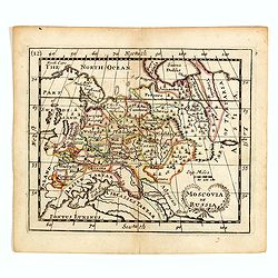
Moscovia or Russia
A rare late seventeenth-century English map of Russia and the Crimea and southern Ukraine, with the northern coast of the Black Sea and its shores. A scarce little map ut...
- $300 / ≈ €260
Date: London, 1685
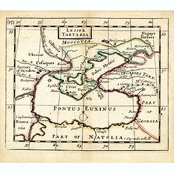
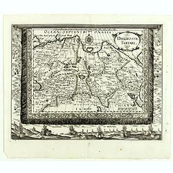
Lesser Tartaria.
A late seventeenth-century English map of the Crimea and southern Ukraine, with the whole of the Black Sea and its shores. A scarce little map utilized in various of the ...
- $300 / ≈ €260
Date: London, 1685
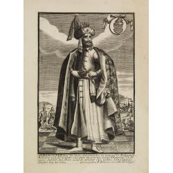
Avrengzebe Roy des Indes Orientales, si zelé po.r. la Religion de Mahomet ..
Very rare and decorative costume plate. Underneath the plate a descriptive text in French.Bears the address : Se vend à Paris chez F. Jollain l aine Rue St Jacques a la ...
Date: Paris, ca. 1685

Zemblien.
Engraving presenting inhabitants of Nova Zembla from his monumental work "Description de L'Univers."
Date: Paris, 1685
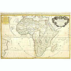
L'Afrique divisée suivant l'estendue de ses principales parties ou sont distingués les vns des autres . . .
A second state of this fine mile-stone map of Africa with a decorative title and scale cartouche. As the title indicates, this map is based on the geography of Guillaume ...
- $750 / ≈ €649
Date: Paris, 1685
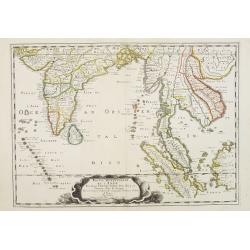
Partie Meridionale de l'Inde en deux presqu'isles. . .
Sanson's important mid-seventeenth century map of India and Southeast Asia, with the engraved date 1686, with the address "Aux Galleries du Louvre" added in bro...
- $800 / ≈ €692
Date: Paris, 1686
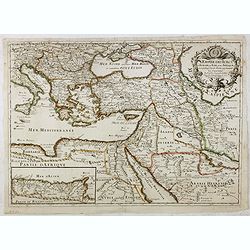
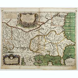
L'Empire des Turcs en Europe, en Asie et en Afrique.
A nice map showing the Turkish Empire, including an inset map of kingdom of Alger. Extending from Italy and the Eastern Mediterranean in the west to the Caspian Sea and P...
- $550 / ≈ €476
Date: Paris, 1686
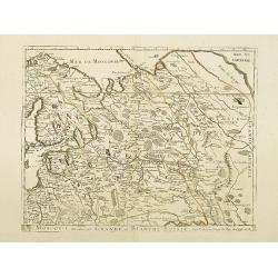
Moscovie dite autrement Grande et Blanche Russie.
Uncommon map of the Russia, including Finland, here with the date 1686.
Date: Paris, 1686
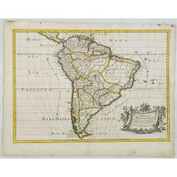
L'America Meridionale . . .
The second edition of Rossi's map of South America, based upon Sanson's map, but with revised Italian nomenclature. From his 'Mercurio Geografico...'. The engraver was G...
Date: Rome, 1687
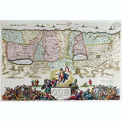
Het Beloofde Landt Canaan door wandelt onser Saligmaecker Jesu Christo neffens sijne Apostelen.
Fine map of the Land of Canaan or the Promised Land with north oriented to right. Large decorative title cartouche at bottom surrounded by vignettes depicting birth, deat...
Date: Amsterdam, 1688
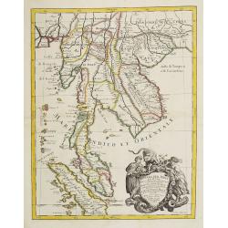
Penisola Dell India di la dal Gange Diusa ne i Regni, che in essasi contengono et accresciuta di varie notizie. Da Giacomo Cantelli da Vignola e conforme le Relationi di alcuni Padri della Compa di Giesu di Monsu Tavernier . . .
Giacomo Rossi's fine late 17th-century map of Malaysia, Thailand, Cambodia and part of Sumatra. The region is shown divided into kingdoms, including Tonkin, Cochinchina, ...
Date: Rome, 1683-1688
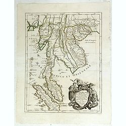
Penisola dell India di là dal Gange. . .
Giacomo Rossi's fine late 17th-century map of Malaysia, Thailand, Cambodia and part of Sumatra. Issued in Il Mercurio geografico In the lower right-hand corner a large ti...
Date: Rome, 1683-1688
La Bulgaria ela Romania con Parte di Marcedonia. . .
Scarce map of the region along the Danube River and to the south. Extends to include part of the Sea of Azov and the northern extreme of the Aegean Sea. Elaborate militar...
- $600 / ≈ €519
Date: Rome, 1689
La Prussia Divisa in Reale Che Appartiene al Ré Di Polonia et in Ducale Che Spetta all'Elettore Di Brandeburgo. Da Giacomo Cantelli Da ...
In the upper left-hand corner a large title cartouche with a dedication to Cardinal Denhoff. The map is dated 1689.The cartographer was Giacomo Cantelli (1643-1695) who w...
- $1000 / ≈ €865
Date: Rome, 1689
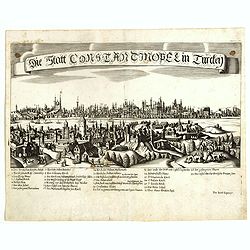
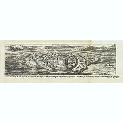
Constantinopolitanae urbis effigies ad vivum expressa.
Extremely rare panoramic view of Istanbul published by Jacob Koppmayr. With a numbered key (1-29) to principal places in town. Jacob Koppmayr was a printer and publisher ...
- $900 / ≈ €779
Date: Augsburg, 1689
Die Grosse Tartari.
Rare map showing Siberia, Korea, with part of the Caspian Sea to the West, as well as India and North Russia. The title is in an oval cartouche in the upper right cornerT...
- $1000 / ≈ €865
Date: Augsburg, 1689
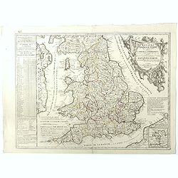
Le Royaume d'Angleterre.
An attractive map centered on England, Wales and the southern part of Scotland. The very decorative cartouche includes a dedication to Jacques II Roy d'Angleterre, d'Esco...
- $650 / ≈ €563
Date: Paris, 1689
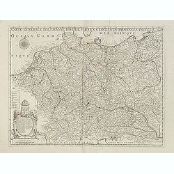
Carte générale d'Alemagne divisée par les cercles ou provinces d'icelle.
Rare and detailed map of Germany, Poland and Austria, engraved by H. le Roy in 1643 or 1666 for Jacques L'Agniet. Published by François Jollain (ca. 1641 – 18 April 17...
- $450 / ≈ €389
Date: Paris, 1689
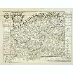
Le Comté de Flandre par P. Placide Augustin. . .
Detailed map of Flanders prepared by P. Placide Augustin, with fine title cartouche and dedication to "Monseigneur Le Marquis de Torcy, Secretaire d'État" in u...
- $350 / ≈ €303
Date: Paris, 1690

Nicolas Bion Ingenieur du Roy . . .
Copper engraved portrait of Nicolas Bion, engraved by Nicolas II de Larmessin (1632-1694). Bion was a French mathematician and maker of globes and scientific instruments....
- $300 / ≈ €260
Date: Paris, ca. 1690

Magnae Prussiae Ducatus Tabula denuo correcta et in lucem edita per Nicolaum Visscher.
Striking old color example of Visscher's map of Prussia and part of the Baltic region. Includes a gorgeous cartouche and banner key held aloft by 2 cherubs, plus 4 sailin...
- $1500 / ≈ €1298
Date: Amsterdam, 1690
Le Coste della Francia sul Mare Oceano.
Uncommon map from "Mercurio Geografico", published in Rome by G. de Rossi. A decorative title and scale cartouches enriching the map. The Italian cartographer C...
- $375 / ≈ €325
Date: Rome, 1690
Isola del Re Nel Mare di Guascogna . . .
A beautiful map showing Ile de Ré in Bretagne, located in the Bay of Biscay off the coast of France, from Vincenzo Coronelli's Corso Geografico Universale.Italian text o...
Date: Venice, 1690
Isola d'Oleron, nella piaggie occidentali della Francia.
A beautiful and rare map showing île d'Oleron.The remarkable Vincenzo Coronelli (1650-1718), encyclopaedist, geographer, inventor and Doctor of Theology, was citizen of ...
Date: Venice, 1690
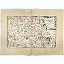
Partie Septentrionale de l'Evesché de Poictiers. Partie Septentrionale du Haut Poitou.
Rare map engraved by R. Michault and published "a Paris chez Greg. Mariette sur le quay de l'Horloge au dessus de la cour de Lamoignon". Dedicated to the Bishop...
Date: Paris, 1690
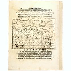
Isola della Guinea. / Isola Gore.
Fine map of Guinea, from Isolario Dell'Atlante Vento.On verso a map of the island Goeree (130x172mm). The sheet dimension is 485x350mm
- $300 / ≈ €260
Date: Venice, 1690
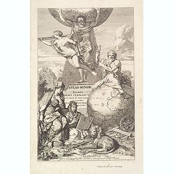
Title page: Atlas Minor sive totius Orbis Terrarum. . .
Finely etched title page from Visscher's Atlas Minor. Showing Atlas supporting the World, and Neptune seated astride a terrestrial globe, showing the Atlantic coasts. Two...
- $400 / ≈ €346
Date: Amsterdam, 1690
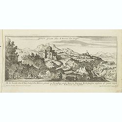
Gebort Plaedt Van S Ioannes des dooper. [Bith place of John Baptist)
Magnificent view of birthplace of John Baptist. Etched by Gaspar Bouttats (1640-1695).The Antwerp based publisher Jacques Peeters published ca. 1690 a series of prints re...
Date: Antwerp, c.1690
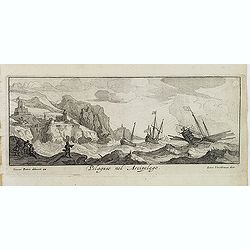
Pelaguse nel Arcipelago. (Pegalos)
Magnificent shipping scene offshore of Pelagos. Engraved by Lucas Vostermans II, who was born in 1624, in the same year when the family moved to England for six years. He...
- $125 / ≈ €108
Date: Antwerp, c.1690
Fanar nel Arcipelago. (Phanar)
Magnificent bird's-eye town-view of Fanar or Phanar, a neighborhood midway up the Golden Horn, within the district of Fatih in Istanbul. Engraved by Lucas Vostermans II, ...
- $150 / ≈ €130
Date: Antwerp, c.1690

Kam Hi Fils de Chien chi Empereur des Tartares orientaux?.plusieurs titres d'honneur Ecrits de sa propre main.
Very rare and decorative costume plate. Underneath the plate a descriptive text in French. Bears the address AParis Chez Nolin rue St. Jacques à l'Enseigne de la Place d...
- $300 / ≈ €260
Date: Paris ca. 1690
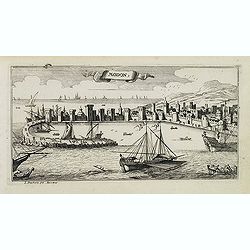
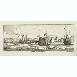
Modon. (Methoni)
Magnificent bird's eye-town-view of Methoni on Morée. Etched by Gaspar Bouttats (1640-1695).The Antwerp based publisher Jacques Peeters published ca. 1690 a series of pr...
- $150 / ≈ €130
Date: Antwerp, c.1690