Browse Listings in Australia & Oceania
![[The attack by Schouten and his men on a waka.]](/uploads/cache/39658-250x250.jpg)
[The attack by Schouten and his men on a waka.]
Scarce print on French text sheet showing the attack by Schouten and his men on a waka.From a description of the voyage of Le Maire and Schouten included in the first Fre...
- $200 / ≈ €175
Date: Amsterdam, 1622
![[Locals.]](/uploads/cache/39659-250x250.jpg)
[Locals.]
Scarce print on French text sheet showing a copper engraved view of locals in Oceania.From a description of the voyage of Le Maire and Schouten included in first French t...
- $150 / ≈ €131
Date: Amsterdam, 1622
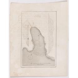
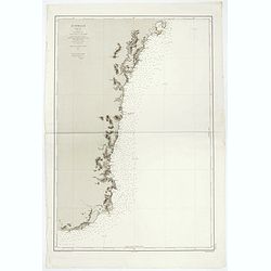
Victoria Harbour.
Chart of Victoria Harbour, showing where stores unloaded, depth readings. Plate from John Ross's Second Voyage in Search of a Northwest Passage, from the book entitled 'N...
Date: London, 1627
Cocos Insel Cocos Insula / Verräter Insel Insula proditorum.
Scarce print (148x204mm.) on a German text sheet showing the landing of Le Maire and Schouten at Cocos Island in May 1616 (today’s Tafahi in the Tonga Islands). Named b...
- $150 / ≈ €131
Date: Frankfurt, M.Merian, 1631
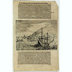
![[The attack by Schouten and his men on a waka.]](/uploads/cache/39754-250x250.jpg)
[The attack by Schouten and his men on a waka.]
Scarce print (145x210mm.) on a German text sheet showing the attack by Schouten and his men on a waka.The page is taken from a first edition of Johann Ludwig Gottfried's ...
- $150 / ≈ €131
Date: Frankfurt, M.Merian, 1631
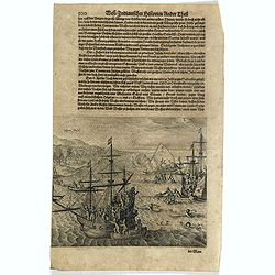
Vligen Insel.
Scarce print (168x200mm.) on a German text sheet showing the attack of mosquitos on Schouten's ship.The page is taken from a first edition of Johann Ludwig Gottfried's &q...
- $75 / ≈ €66
Date: Frankfurt, M. Merian, 1631
![[The description of Horn's Island].](/uploads/cache/41103-250x250.jpg)
[The description of Horn's Island].
This was a charming and beautiful island, full of coconuts, upas-root and wild pigs, which the natives either offered or sold to the Dutch. The natives seemed very wild a...
Date: Frankfurt, M.Merian, 1633
![[The natives eat, drink and dance for their king].](/uploads/cache/41104-250x250.jpg)
[The natives eat, drink and dance for their king].
Food was carried on the natives’ heads as they humbly crept forward on their knees to greet the Dutch. The drink, called cava, was made from a certain plant, which they...
Date: Frankfurt, M.Merian, 1633
![[The Dutch are received at another island in Samoa].](/uploads/cache/41105-250x250.jpg)
[The Dutch are received at another island in Samoa].
On visiting another island [in Samoa] the Dutch were made heartily welcome by the king and all the inhabitants. A king of another neighbouring island also called to meet ...
Date: Frankfurt, M.Merian, 1633
![[The adventures of the Dutch at 'Bottomless' island in Samoa].](/uploads/cache/41106-250x250.jpg)
[The adventures of the Dutch at 'Bottomless' island in Samoa].
The Dutch arrived at an island [in Samoa] fringed with wild vines on which there were native men with long hair and native women with short hair. Because the water surrou...
Date: Frankfurt, M.Merian, 1633

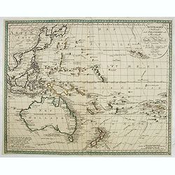
.Pascaerte Vande Zuyd-Zee tusschen California, en Ilhas de Ladrones. . .
A decorative and most interesting map - being one of the earliest of the Pacific to record the observations of Tasman's voyages. The northern part of the island of Califo...
Date: Amsterdam, 1666
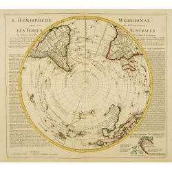
L'Hemisphere Meridional pour voir plus distinctement les Terres Australes.
Decorative map depicting from the southern pole to the Equator with good detail, and showing all the political divisions.Showing South America, southern Africa, the west ...
Date: Amsterdam, c. 1745
![Le Capitaine Wallis est attaqué dans le Dauphin par les Otahitiens. [Tome II Pl. 1ère.]](/uploads/cache/26099-250x250.jpg)
Le Capitaine Wallis est attaqué dans le Dauphin par les Otahitiens. [Tome II Pl. 1ère.]
Scene of an attack by local Tahitians on Captain Wallis' Dolphin ship off Tahiti's shore. Samuel Wallis (1728-95), a Royal Navy Captain and a skilled navigator was given ...
- $150 / ≈ €131
Date: Paris, 1773
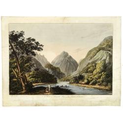
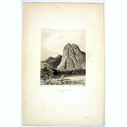
![Vue d'un Rocher troué de la Nouvelle Zélande. [Tome III Pl. 8.]](/uploads/cache/29073-250x250.jpg)
Vue d'un Rocher troué de la Nouvelle Zélande. [Tome III Pl. 8.]
A view of a New Zealand landscape and seascape through a hollow rock. Engraved by Demouchy. From the French edition of James Cook's first voyage entitled Relation des voy...
- $75 / ≈ €66
Date: Paris, 1773
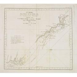
Carte d'une Partie de la Côte, de la Nle Galles Meridle depuis le Cap Tribulation jusqu'au Detroit de l'Endeavour par le Lieut. J. Cook 1770. Tome IV. Pl. 3.
Map of a part of the New galles Meridle Coastline in Australia from the Cap Tribulation to the Endeavour Detroit. This map is taken from the first French edition of Jame...
Date: Paris, 1774
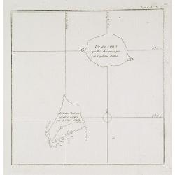
Isles des Cocos appellée Bosscaiven par le Capitaine Wallis / Isles des Traîtres appellée Keppel par le Capitaine Wallis. Tome II Pl. 4.
Chart of the Cocos and Keeppel Islands. The territory of Cocos (Keeling) Islands, also called Cocos Islands and Keeling Islands, is a territory of Australia. This map is ...
- $50 / ≈ €44
Date: Paris, 1774
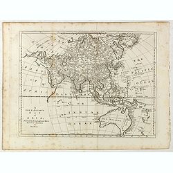
A new and accurate map of Asia, Drawn from the most approved modern maps & charts / by Thos. Bowen.
The map is of interest for the use of Sea of Korea for the sea between Korea and Japan.Detailed map of Asia from Saudi Arabia, Persia, Russia, India, China, Japan to Sout...
Date: London, J.Cooke, 1777-1778
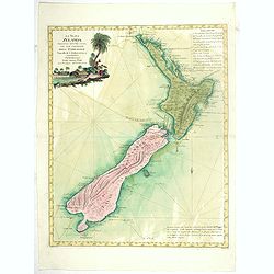
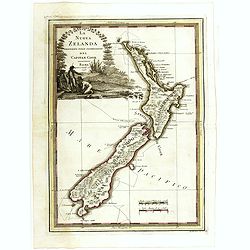
La Nuova Zelanda tracorsa nel 1769 e 1770 dal Cook commandante dell' Endeavour Vascello di S.M.Britannica.
Antonio Zatta’s map of New Zealand is not only one of the first to show the results of Cook’s voyages, but is also one of the most attractive of the islands. Consider...
Date: Venise, 1778
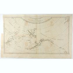
Carte de l'Entrée de Norton, et du Detroit de Bhering ou Von vou le Cap le plus oriental de l'Asie, et la Pointe la plus occidentale de l'Amerique.
Early detailed map of the passage between Asia and the NW Coast of America, including nice topographical details and the day by day tracks of Cook through the region in 1...
- $300 / ≈ €262
Date: Paris, 1785
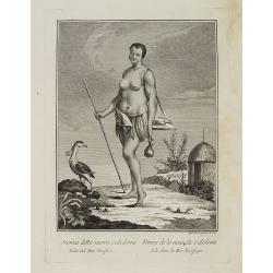
Donna della nuova Caledonia Isola del Mar Pacifico. / Femme de la nouvelle Calédonie Isle dans la Mer Pacifique.
Full portrait of a woman from New Caledonia. A rare engraving from "Raccolata di stampe ... di varie nazioni". From the original drawing by William Hodges, who ...
Date: Venice, Antonio Zatta, c.1790
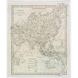
![[Asia and part of Australia]](/uploads/cache/26453-250x250.jpg)
[Asia and part of Australia]
An engraved map of Asia shows an oversized Japan and part of Australia, called Neu Holland. To the east of the Caspian Sea, we see the area of present-day Uzbekistan and ...
- $450 / ≈ €393
Date: Tübingen, Heerbrandt, 1790
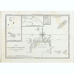
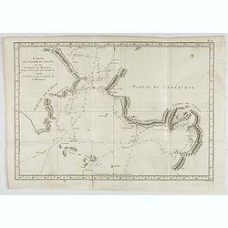
Isles de la Reine Charlotte.
Four charts on one page including chart of Nendö Island, largest of the Santa Cruz Islands, part of the Solomon Islands group, as mapped by Captain Cartaret in 1767, the...
- $40 / ≈ €35
Date: Paris, 1790
![[Lot of 6 maps / prints] Schets van de Donkere Baai in Nieuw Zeeland 1773.](/uploads/cache/20531-(1)-250x250.jpg)
[Lot of 6 maps / prints] Schets van de Donkere Baai in Nieuw Zeeland 1773.
A map of Dusky Bay, visited by James Cook in 1773. From a Dutch edition of ‘Cook's voyages'. Schets van de Donkere Baai in Nieuw Zeeland 1773. Nicolas Bellin's map of t...
- $350 / ≈ €306
Date: London, c, 1790
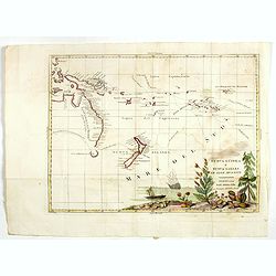
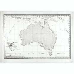
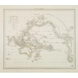
Nuova Guinea e Nuova Galles ed Isole Adjacenti
Map of the South Pacific, showing the sailing routes to the South Pacific by Carteret and Byron, but most importantly the discoveries made by Captain Cook, 1768-1771. The...
- $1750 / ≈ €1529
Date: Venise, 1794-1796
![[Lot of 2 maps] Important plan of Port Bucarelli 1384 / Chart of the entrance of "Bassin de L'Quest", La Perouse. 1709](/uploads/cache/20473-250x250.jpg)
[Lot of 2 maps] Important plan of Port Bucarelli 1384 / Chart of the entrance of "Bassin de L'Quest", La Perouse. 1709
Chart of the entrance of "Bassin de L'Quest", La Perouse. 1709 / With antique print of Alaska] Pirogue du port des Francais. / Pirogue, trouvee au port des Fran...
- $350 / ≈ €306
Date: Paris, 1797
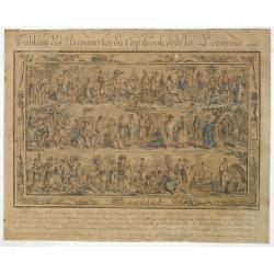
Tableau des Decouvertes du Cap.ne Cook, & de la Pérouse.
Three series of figures of natives with key below, surrounded by narrow pictorial border.Grasset de Saint Sauveur skillfully wove together two dozen individual scenes fro...
- $2200 / ≈ €1922
Date: Paris, 1798
La nuova Zelanda delineate sulle ultima osservazioni del Capitan Cook.
First edition on laid paper Cassini’s splendid early map of New Zealand, being the most decorative version of Captain Cook's map of New Zealand, published in the very s...
Date: Rome, 1798
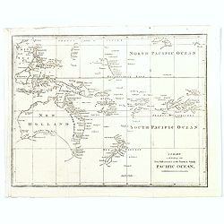
A Chart exhibiting the New Discoveries in the North & south Pacific Ocean.
A scarce map, probably from an English travel journal, produced in the late eighteenth century, showing the latest cartographic discoveries within the Pacific region. Map...
Date: London, ca. 1800
Kaart van de Noord-West kust van Amerika en de Noord-Oost kust van Asia. . .
A uncommon issue of this important map of the Northern Pacific and contiguous coasts of America and Asia, published in 'Reize rondom de Waereld door James Cook', a Dutch ...
- $1000 / ≈ €874
Date: Leyden, Amsterdam & The Hague: Honcoop, Allart & van Cleef, 1795-1801
(RESERVED) A view in Oheitepeha Bay in the Island of Otaheite. (Tahiti)
A view of Vaitepiha Bay (Tahiti), with a mountainous landscape, with a river in the centre, a small canoe, Tahitian houses to the right, and a Tahitian couple in the left...
Date: London, Boydell and Co., 1808
Asia, drawn from the latest Astronomical Observations.
This finely engraved, and detailed, map of Asia shows the extent of knowledge from astronomical observations at the time. It is also of interest for showing Australia her...
Date: London ca. 1808
Carte Generale de la Nouvelle Hollande.
Fine map of the continent of Australia prepared by Louis Freycinet during his voyage under Captain Thomas Baudin in 1800-1803. Freycinet's map of New Holland was the firs...
- $5000 / ≈ €4368
Date: Paris, Imprimerie Royale, 1811

Voyage de découvertes aux Terres Australes. Historique. Atlas Deuxième partie.
First edition of the second part of the atlas by Freycinet, part of his important book "Voyage de découvertes aux Terres Australes". Illustrated with two foldi...
- $7500 / ≈ €6552
Date: Paris, Langlois, 1811
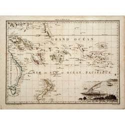
Océanique Oriente.
Drom the Carolines to New Zealand and east to Pitcairn Island with Australia from Torres Strait to Tasmania. Engraved by J.B.Tardieu and prepared by Giraldon.From Conrad ...
- $300 / ≈ €262
Date: Paris, 1809/1812
![Plan d'une partie de la Terre Napoléon [with] Plan des Iles Joséphine et de la Baie Murat.](/uploads/cache/46367-250x250.jpg)
Plan d'une partie de la Terre Napoléon [with] Plan des Iles Joséphine et de la Baie Murat.
Two maps showing Descartes Bay and Bridgewater Bay in Victoria and Murat Bay in South Australia showing French discoveries prepared by Louis Freycinet during his voyage u...
- $100 / ≈ €87
Date: Paris, 1807-1816
![Plan des Iles Jérôme [with] Plan des Iles Berthier [with] Plan du Comté de Cumberland.](/uploads/cache/46370-250x250.jpg)
Plan des Iles Jérôme [with] Plan des Iles Berthier [with] Plan du Comté de Cumberland.
Three maps on one sheet, Jérôme islands, Berthier islands and Cumberland county, from Voyage de découvertes aux terres Australes by François Péron, 1824. The French ...
- $100 / ≈ €87
Date: Paris, 1807-1816
![Plan du Port du Roi-George [with] Plan de la Baie du Geographe.](/uploads/cache/46371-250x250.jpg)
Plan du Port du Roi-George [with] Plan de la Baie du Geographe.
Two maps on one sheet, King George Sound and Geographe Bay, now Busselton and Dunsborough area and the earliest chart of this area, from Voyage de découvertes aux terres...
- $500 / ≈ €437
Date: Paris, 1807-1816
Australien (Südland) auch Polynesien oder Inselwelt..
SECOND EDITION of the Johann Walch map of Australasia and the South Pacific. Australia lettered Neu Holland, the name given to it by Able Tasman that was still in use un...
Date: Augsburg, 1802-1820
![Nouvelle-Hollande. Oui-Re-Kine. [plate XXI]](/uploads/cache/40110-250x250.jpg)
Nouvelle-Hollande. Oui-Re-Kine. [plate XXI]
A portrait of a female aboriginal residing in Sydney.After the original sketches by Lesueur, from Voyage de découvertes aux terres Australes by François Péron, 1824.Th...
- $100 / ≈ €87
Date: Paris, 1824
![Nouvelle-Hollande: Nouvelle Galles du Sud. Navigation. [plate XXIII]](/uploads/cache/40112-250x250.jpg)
Nouvelle-Hollande: Nouvelle Galles du Sud. Navigation. [plate XXIII]
Aboriginal boats, used for hunting and water transportationAfter the original sketches by Lesueur, from Voyage de découvertes aux terres Australes by François Péron, 1...
- $100 / ≈ €87
Date: Paris, 1824
![Phisique. [plate XL]](/uploads/cache/40124-250x250.jpg)
Phisique. [plate XL]
Some scientific instruments for measuring the sea temperature at some depth. From Voyage de découvertes aux terres Australes by François Péron, 1824.The French expedit...
- $40 / ≈ €35
Date: Paris, 1824
![Nouvelle-Hollande. Gnoung-A-Gnougn-A, Mour-Re-Mour-Ga ( Dit Collins). [plate XVII]](/uploads/cache/46280-250x250.jpg)
Nouvelle-Hollande. Gnoung-A-Gnougn-A, Mour-Re-Mour-Ga ( Dit Collins). [plate XVII]
A portrait of a male Tasmanian Aboriginal Gnoung-A-Gnougn-A, Mour-Re-Mour-Ga ( Dit Collins) by Lesueur, from Voyage de découvertes aux terres Australes by François Pér...
- $100 / ≈ €87
Date: Paris, 1824
![Nouvelle-Hollande: Ile Decrès. - Détails du Casoar de la Nouvelle Hollande. [plate XLL]](/uploads/cache/46362-250x250.jpg)
Nouvelle-Hollande: Ile Decrès. - Détails du Casoar de la Nouvelle Hollande. [plate XLL]
Plate illustrating Casoar, by Lesueur, from Voyage de découvertes aux terres Australes by François Péron, 1824.The French expedition under Nicolas Baudin, was commissi...
- $75 / ≈ €66
Date: Paris, 1824
![[ Ippah village New Zealand ].](/uploads/cache/25857-250x250.jpg)
[ Ippah village New Zealand ].
Aquatint depicting a view of Ippah, a village built on a rock. Engraved by G.Castellini. Plate N° 66. From Giulio Ferrario's work Le Costume Ancien et Moderne ou Histoir...
- $100 / ≈ €87
Date: Milan, 1827
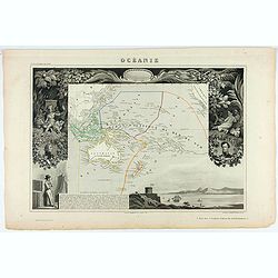
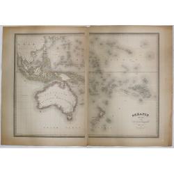
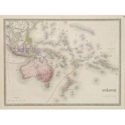
Océanie ou Australasie et Polynesie . . .
Detailed map of Oceania, prepared by A. H. Basset, rue Saint-Jacques, no. 64, Paris and published in Atlas classique et Universel de Géographie . . . .The engraver of th...
- $150 / ≈ €131
Date: Paris, A.H. Basset, 1828
Carte générale de l'océan pacifique. . .
depicting the Pacific Ocean, with nice detail of Hawaii. With a complete outline for Australia and Tasmania. Shows the south east Asian region and South America.Mapping ...
Date: Paris, 1833
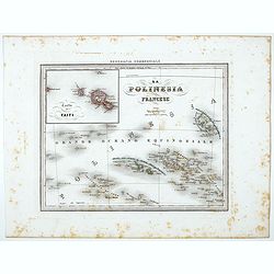
Carte particuliere de la Polynesie. . .
Prepared by A.Brué in 1826 and published by Charles Piquet. Two maps on one sheet, showing the Polynesian islands. In upper left an inset map of Formosa and the coast o...
- $150 / ≈ €131
Date: Paris, 1834
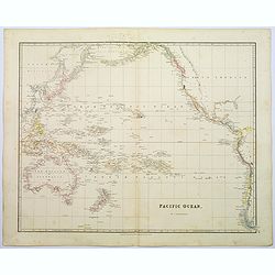
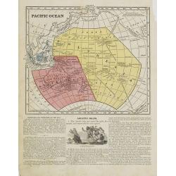
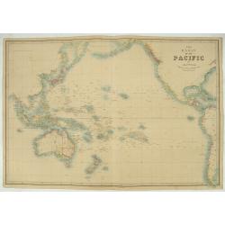
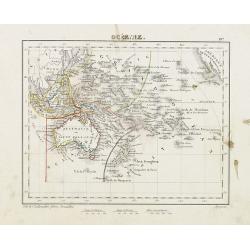
Pacific Ocean.
A wonderfully laid out map of the region, displaying the many island groups that make up this fascinating part of the world. The region is separated into parts, the South...
Date: London, 1839
Oceana or Pacific Ocean.
A lovely detailed map of the Pacific, centered on Hawaii, from an early edition of Tanner's New Universal Atlas. From Russian America (AK) to Patagonia, and from New Zeal...
- $100 / ≈ €87
Date: Philadelphia, ca 1840
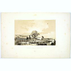
Montagne de la Manchiri.
Lithograph of the Montagne de la Manchiri in Papua New Guinea. It shows Breton, the artist on Dumont D'urville's voyage setting up a camera obscura in the foreground. Pla...
Date: Paris, 1842
Pecheurs de Tripang a la Baie Raffles.
Fine lithograph of Javanese fishermen in the Bay of Raffles. Located at the eastern end of the Cobourg Peninsula, Raffles Bay was the site of the second abortive attempt ...
Date: Paris, 1842
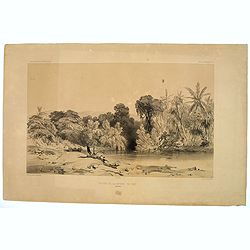
Entrée de la Riviere de Paiou.
A lithograph showing the entrance to the river Paiou on Vanikoro Island, a part of the Santa Cruz Group and the Solomon Islands in the Pacific. Plate 97 taken from the 'V...
- $50 / ≈ €44
Date: Paris, 1842
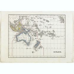
Océanie.
Detailed map of Oceania, including Indonesia and the Pacific Ocean with Hawaii, prepared by Charles V. Monin (fl.1830-1880) a French cartographer of Caen and Paris. Publi...
- $50 / ≈ €44
Date: Paris, 1845
![Oceanie. [Manuscript on paper]](/uploads/cache/01830-250x250.jpg)
Oceanie. [Manuscript on paper]
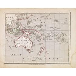
Decorative manuscript map on paper covering South East Asia, Australia and New Zealand.
Date: France ?, ca. 1850
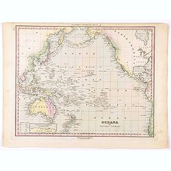
Océanie.
A very decorative 19th century map of the Pacific Ocean, with hand colored lines indicating the extent of Polynesia, Micronesia, Melanesia, and Malaysia (or Southeast Asi...
- $120 / ≈ €105
Date: Paris, 1850
Océanie.
A very decorative 19th century map of the Pacific Ocean, with hand colored lines indicating the extent of Polynesia, Micronesia, Melanesia, and Malaysia (or Southeast Asi...
Date: Paris, 1850
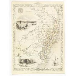
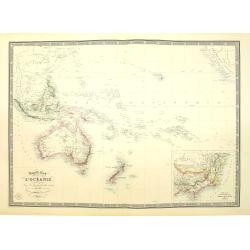
New South Wales.
Decorative steel engraved map of New South Wales, surrounded by illustrations of Sydney Cove, native trees and the seal of New South Wales. Interlocking border design. Ta...
- $300 / ≈ €262
Date: London, ca. 1851
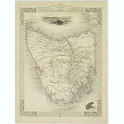
Van Diemen's Island or Tasmania.
Decorative steel engraved map of Tasmania. Taken from "The illustrated atlas and modern history of the world by John Tallis", published between 1849 and 1853. T...
- $225 / ≈ €197
Date: London, 1851
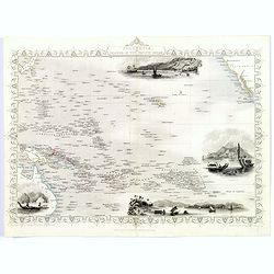
Polynesia or Islands in the Pacific Ocean.
Decorative and attractive map of the Islands in the Pacific Ocean. The map extent shows parts of California, Papua New Guinea, eastern Australia, and southern Japan.The m...
- $175 / ≈ €153
Date: London ,1851
Océanie dressée par A.H. Dufour géographe.
Wall-sized map (87x117cm) in two sheets prepared by Adolphe Hippolyte Dufour, giving good detail to Australia and New Zealand, due to extensive discoveries of the French ...
- $1200 / ≈ €1048
Date: Paris, 1854
Pacific Ocean.
Map of the Pacific Ocean with its Polynesian islands, and New Zealand and Australia. From Sidney E. Morse''s: System of Geography for the use of schools , published by Ha...
- $30 / ≈ €26
Date: New York, 1855
La Polinesia Francese.
Uncommon map of French Polynesia prepared by Francesco Costantino Marmocchi. Above the map "Geografia Commerciale". From "Il Globo Atlante di carte Geograf...
Date: Genova, Paolo Rivara fu Giacomo, 1858
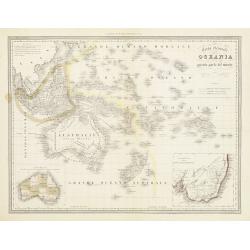
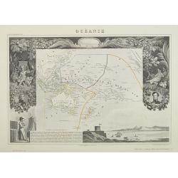
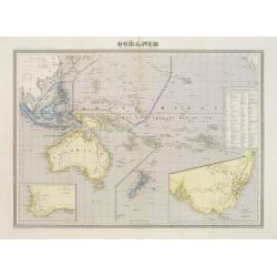
Carta Generale dell' Oceania ossia quinta parte del mondo.
Attractive original outline color large map of the whole of Oceania covering South East Asia, the many and various groups of Pacific Islands, Australia and New Zealand pr...
- $175 / ≈ €153
Date: Turin ca. 1860
Les divers archipels de L'Oceanie.
Very detailed map from Atlas Sphéroïdal & Universel de geographie , Prepared by F.A.Garnier and edited by Jules Renouard, rue de Tournon, Paris. Uncommon map with d...
- $150 / ≈ €131
Date: Paris, 1861
The Basin of the Pacific…
Very detailed map of the Pacific Ocean, including Australia, New Zealand, Japan, Hawaii, etc.James Wyld (the younger) was geographer to the Queen and H.R.H. Prince Albert...
- $200 / ≈ €175
Date: London, 1855/1864
Océanie.
Detailed map of Australia, New Zealand, Indonesia and the Pacific. With a color key indicating English, French, Dutch, Spanish and Portuguese possessions in the region. F...
- $100 / ≈ €87
Date: Paris, 1865
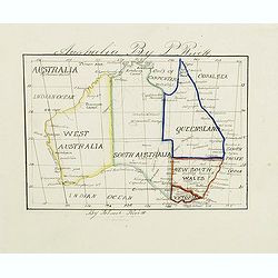
Australia by P.Rivett.
Manuscript map of Australia without Tasmania, prepared by Palmer Rivett, who was born around 1858 in Blundeston, Suffolk, England, where he spent most of his life. He was...
Date: c. 1860-1870
New Zealand 1870
Manuscript map of new Zealand, signed in lower border "By Ernst Pivett. Perhaps a school exercise map.
- $200 / ≈ €175
Date: London, ca. 1870
Australien, von E. van Sÿdow.
Large School wall map of Australia and New Zealand, including some islands in the Pacific, including Hawaii. Prepared by Emil von Sydow (1812 - 1873), who was a Prussian ...
- $1000 / ≈ €874
Date: Gotha, H. Kiepert, 1873
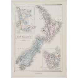
New Zealand.
A detailed lithographed map of New Zealand. With in upper left corner inset-map of Western Australia and in lower right hand corner a map of Van Diemens Land. Published b...
- $100 / ≈ €87
Date: Edinburg, 1874
Océanie.
In lower right hand corner a view of Nouméa. Showing the Pacific including California. Engraved by L.Smith.
- $90 / ≈ €79
Date: Paris, 1874
Australie (Côte Est) Feuille N°10 Partie comprise entre La Baie Jervis et le Cap Everard . . .
Large French sea chart featuring the eastern coast of Australia. Engraved by J.Millian. The chart is based on surveys by the British Captn. F.W. Sidney, Staff Comr., H.J....
Date: Paris, 1874
Océanie dresée par C.V.Monin.
Fine and uncommon map including Australia, New Zealand, Indonesia, with inset maps of New Zealand, Victoria/New South Wales and Western Australia including Albany and Per...
- $150 / ≈ €131
Date: Paris, 1875
Nouvelle carte de l'Océanie dressée d'après les documents les plus récents par A. Vuillemin, géographe.
Very large, highly detailed and uncommon map of the Pacific with Australia and New Zealand, with inset map of "Partie de l'Australie (Nouvelle Galles du Sud) et Vict...
Date: Paris, 1876

Océanie.
Decorative map of the Pacific Ocean including Indonesia, Australia, New Zealand and California. Lower right inset map Détails de la Nouvelle Galles Méridionale , includ...
- $120 / ≈ €105
Date: Paris 1880
Océanie.
Small map of Australia, New Zealand and the Pacific. The area is divided in different parts. Lithographed by C.Callewaert from Brussels.
- $80 / ≈ €70
Date: Bruxelles, c. 1880
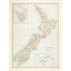
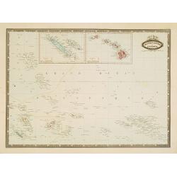
New Zealand.
Very detailed map of New Zealand, with inserts of Tasmania and Fiji Islands. The map was printed from lithographic stones taken from a hand-engraved steel plate. The cart...
Date: Edinburg, ca 1881
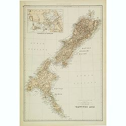
New Zealand (with Environs of Auckland)
Striking map of New Zealand, with a large inset map of the environs of Auckland. Made by J. Bartholomew. NO. 66 in lower right corner.
- $200 / ≈ €175
Date: Glasgow, London, 1882
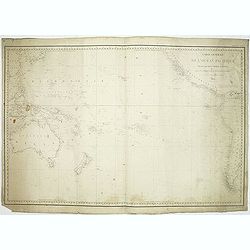
![[2 Sheets] Carte Générale de l'Océan Pacifique Dressée Par Mr. C. A. Vincendon-Dumoulin. . . Pl. 1. N° 1092. / Ocean Pacifique Feuille 2. . . Pl. 2. N° 1093.](/uploads/cache/26731-250x250.jpg)
[2 Sheets] Carte Générale de l'Océan Pacifique Dressée Par Mr. C. A. Vincendon-Dumoulin. . . Pl. 1. N° 1092. / Ocean Pacifique Feuille 2. . . Pl. 2. N° 1093.
Two sea charts depicting the Pacific Ocean, with nice detail of Hawaii. Sheet 1 shows the south east Asian region. The second North America and part of South America. Pre...
- $900 / ≈ €786
Date: Paris, 1845, updated for 1884
