Browse Listings in Australia & Oceania
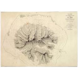
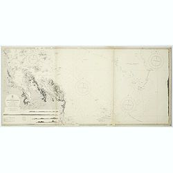
Océan Pacifique. Archipel de la Société. Iles Raiatea et Tahaa. 1ère Feuille. Ile Tahaa..
Large scale chart focused on the island Tahaa, in French Polynesia.Showing a few details of the village of Tahaa, banks, isles and soundings made in meters. Relief is sho...
- $200 / ≈ €175
Date: Paris, 1885
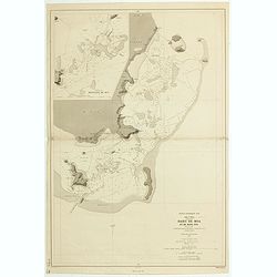
ILE UVEA CROQUIS DES BAIES DE MUA ET DE MATA UTU.
Mata-Utu is the capital of Wallis and Futuna, an overseas collectivity of France. It is located on the island of Uvéa, in the district of Hahake, of which it is also the...
- $80 / ≈ €70
Date: Paris, 1887
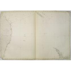
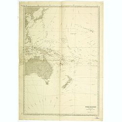
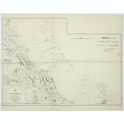
Carte de la Mer comprise entre l'Australie, la Nelle. Zélande et la Nelle.
Sea chart of the Pacific Ocean between Australia, New Zealand and New Caledonia. Including the towns of Sydney, Brisbane. The northern tip of New Zealand in lower right c...
- $350 / ≈ €306
Date: Paris, 1872 updated for 1888
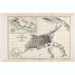
New Guinea. Map illustrating Sir. w. Macgregor's route to the Owen Stanley Range 1889.
Map illustrating Sir. w. Macgregor's route to the Owen Stanley Range 1889. With inset map of South-East New Guinea.Fine colored lithograph map lithographed by Turner &...
- $50 / ≈ €44
Date: London, Edward Stanford, 1890
![[Australia and Polynesia].](/uploads/cache/46141-250x250.jpg)
[Australia and Polynesia].
Alexey Afinogenovich Ilyin was a lieutenant general and cartographer (1832-1889). In 1856, after graduating from the Academy of the General Staff, he was at the military ...
- $150 / ≈ €131
Date: St. Petersburg, 1899
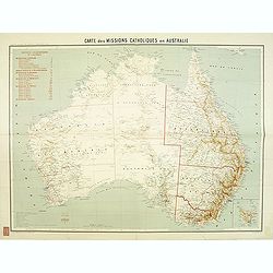
Carte des missions Catholiques en Australie.
Rare and detailed map of Australia (Scale 1:5 000 000) showing Catholic dioceses and bishops' residences, but not missions, on a topographic basis. Relief is shown by hac...
Date: Lyon / Paris, 1906
Ocean Pacifique Partie Ouest.
Large French sea chart featuring the western part of the Pacific Ocean with Australia, New Zealand, New Guinea, Philippines, till Korea and Japan, corrected in 1929.On th...
- $450 / ≈ €393
Date: France, 1909-1929
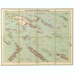
Principaux archipels d'Oceanie.
Detailed folding map of seven principal island groups in the South Pacific represented at various scales. The number and title are also on the outside front of the sheet....
- $120 / ≈ €105
Date: Paris, ca. 1930
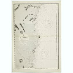
Sheet VI East coast of Australia. New South Wales Tacking Point to Coffs Islands surveyed by Comr. Fredk. W. Sidney R.N. . . 1862 - 1864. . .
Large chart representing East coast of Australia with New South Wales including Tacking Point to Coffs Islands surveyed by Comr. Fredk. W. Sidney R.N. from 1862 - 1864. F...
- $150 / ≈ €131
Date: London, 1939-1942
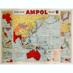
Pacific AMPOL Map
A large and very colorful World War II era map of the Pacific Ocean produced with the complements of the Australian Motorists Petrol Co. Ltd. The map itself shows the Pac...
- $1000 / ≈ €874
Date: Australia, ca 1942
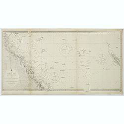
Australia, Coral Sea and Great Barrier Reefs shewing the inner and outer routes to Torres Strait. Sheet 1. . .
Large scale chart representing the Great Barrier Reef and the Coral Sea showing routes to the Torres Strait. Sheet 1.First published at the Admiralty 1860 with new editio...
- $150 / ≈ €131
Date: London, 1869-1943
East coast of Australia. New South Wales. Sheet VII, Coffs Islands to Evans Head surveyed by Comr. Fredk. W. Sidney R.N. assisted by E.P. Bedwell & J.T. Gowlland, Masters & S. Guy, 2nd Master R.N. 1864-5
Large chart representing East coast of Australia with New South Wales including Coffs Islands to Evans Head surveyed by Comr. Fredk. W. Sidney R.N. First published at the...
- $150 / ≈ €131
Date: London, 1907-1943
Sheet V East coast of Australia. New South Wales Evans Head to Danger Pt. surveyed by Comr. Fredk. W. Sidney R.N. . . 1864-5. . .
Large chart representing East coast of Australia with New South Wales including Evans Head to Danger Pt. surveyed by Comr. Fredk. W. Sidney R.N. from 1864 - 1865. First p...
- $150 / ≈ €131
Date: London, 1866-1943
Australia - East coast Queensland Keppel Bay and Islands surveyed by staff Commr. J.Jeffery. . . 1864. . .
Large chart representing East coast of Australia with Queensland including Keppel Bay and Islands surveyed by Comr. J.Jeffery in 1864. First published at the Admiralty 3r...
- $150 / ≈ €131
Date: London, 1866-1943
Sheet XI East coast of Australia - Sandy Cape to Keppel isles surveyed by Staff Commr. E.P. Bedwell, Navg. Lieutt. E.H.S. Bray, and Navg. Sub. Lieutt. E.R. Connor, 1870
Large chart representing East coast of Australia from Sandy Cape to Keppel isles surveyed by Staff Commr. E.P. Bedwell. With two inset charts of Pancake Creek. Scale 1:24...
- $150 / ≈ €131
Date: London, 1883-1944
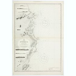
Sheet XII East coast of Australia Queensland Keppel Isles to Percy Isles. . .
Large chart representing east coast of Australia's Queensland showing Keppel Isles to Percy Isles with relief shown by hachures, spot heights and bathymetric soundings. S...
- $150 / ≈ €131
Date: London, 1932-1944
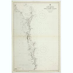
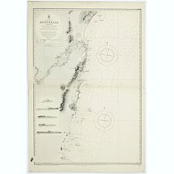
Australia - East coast. Cape Byron to Lady Elliot Island compiled chiefly from Admiralty surveys, 1863-70.
Large chart representing Cape Byron to Lady Elliot Island, Australia, east coast with relief shown by hachures, spot heights and bathymetric soundings. Compiled chiefly ...
Date: London, 1907-1944
![Australia, E. coast - Queensland Percy isles to Whitsunday I. chiefly from a joint Admiralty & Colonial survey by Staff Commander Bedwell, R.N. 1873 to 1879 [1945]](/uploads/cache/36212-250x250.jpg)
Australia, E. coast - Queensland Percy isles to Whitsunday I. chiefly from a joint Admiralty & Colonial survey by Staff Commander Bedwell, R.N. 1873 to 1879 [1945]
Large chart representing East coast of Australia with Queensland from Percy isles to Whitsunday Island, with inset of Beverley Islands Anchorage. Scale 1:74,000. in lower...
- $150 / ≈ €131
Date: London, 1882-1945
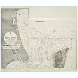
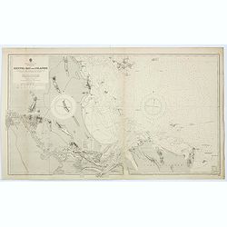
Australia, E. coast - Queensland Moreton Bay
Large chart representing East coast of Australia with Moreton Bay in Queensland.After a survey by Comr. J.Jeffery, etc. in 1865. New edition at the Admiralty 1870. With ...
Date: London, 1882-1945
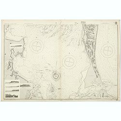
Australia, E. coast - Queensland Moreton Bay
Large chart representing East coast of Australia with Moreton Bay in Queensland.After a survey by Comr. J.Jeffery, etc. in 1865. New edition at the Admiralty 1870. With ...
- $120 / ≈ €105
Date: London, 1882-1945
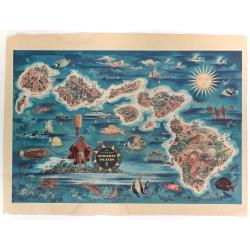
The Dole Map of the Hawaiian Islands.
A terrific, colorful poster of the Hawaiian Islands by Joseph Feher, commissioned for the Hawaiian Pineaple Co. The poster displays all eight of the major islands in the ...
- $250 / ≈ €218
Date: USA, 1950
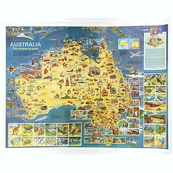
Australia, The Awakening Giant.
This large, fully colored map of Australia was published in America and Australia in the late 1960s. The map is covered in small colored illustrations, connected with loc...
Date: Victoria, 1967
