Browse Listings in Asia
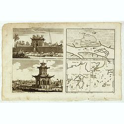
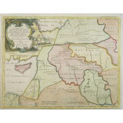
Chinese Temples. Sin-Ko-Tsyen. Canton, Sancian Isle. Ma-Kao.
An attractive print divided into four areas, two depicting Chinese temples and the other two with maps of the city of Canton, the island of Sancian and the island of Ma-K...
- $75 / ≈ €66
Date: London, 1745-1747
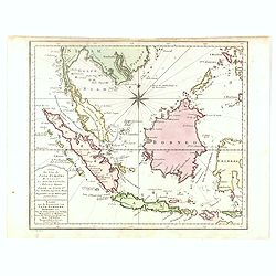
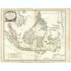
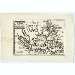
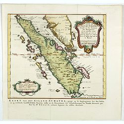
Carte des Isles de Java, Sumatra, Borneo. . . Malaca et Banca. . . / Kaart van de Eilanden van Java. . .
Dutch edition of this map of Indonesia prepared by N. Bellin and published by Pierre d'Hondt in Amsterdam. Jaques Nicolas Bellin (1703-1772) was one of the most important...
- $400 / ≈ €349
Date: Amsterdam, 1747
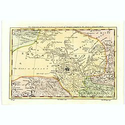
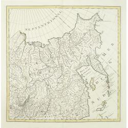
The Empire of Hya (including grear part of Tangul)...
Uncommon map of the Gobi Desert.Engraved by Thomas Kitchin - with his signature in lower bottom.From Astley, Thomas, "A New General Collections of Voyages and Travel...
- $100 / ≈ €87
Date: London, 1745-1747
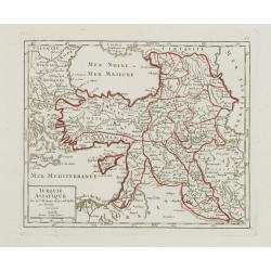
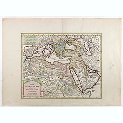
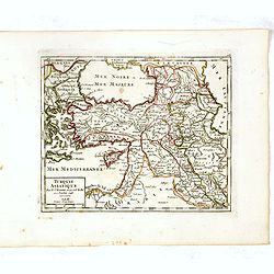
Turquie Asiatique..
Small detailed map of the Near East, including Cyprus, the Black Sea and Georgie. From Atlas Portatif Universel, by Robert de Vaugondy.Page 65 outside border top right. M...
- $100 / ≈ €87
Date: Paris, later than 1748
Afbeelding van all de Landen gelegen tusschen de Middellandsche, Zwarte, Caspische, Persische en Rode Zeën.
A map of the Near East, with an oversized Cyprus. From a Dutch bible published by Nicolaas Goetzee. Willem Albert Bachiene (1712-1783), Dutch geographer in Maastricht. Mo...
- $300 / ≈ €262
Date: Gorichem, Nicolaas Goetzee, 1748
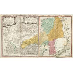
No title (Carte générale de l'empire de Russie).
The right hand sheet of a map of the Empire of Peter the Great.This important map is based on maps from the Bering expedition and on De L'Isle's Akademiia nauk Atlas of 1...
- $800 / ≈ €699
Date: Amsterdam, ca.1748
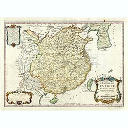
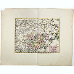
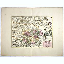
L'Empire de la Chine.
A fine map of China, Korea and Taiwan.Jacques Nicholas Bellin (1703-1772) was one of the most important and proficient French cartographers of the mid-eighteenth century....
- $450 / ≈ €393
Date: Paris, 1748
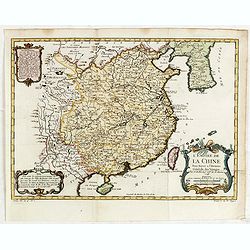
L'Empire de la Chine. . .
A fine map of China, Korea and Taiwan.Jacques Nicholas Bellin (1703-1772) was one of the most important and proficient French cartographers of the mid-eighteenth century....
- $450 / ≈ €393
Date: Paris, 1748
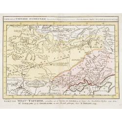
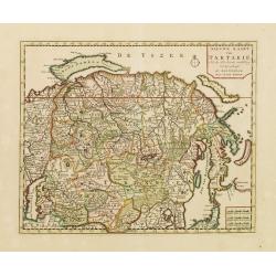
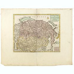
Carte de la Tartarie Occidentale.
Uncommon issue of this finely engraved map showing China's capital city of Peking inland from the Gulf of Lyau-tong. The map locates northeastern China to the border of R...
- $150 / ≈ €131
Date: Amsterdam, 1749
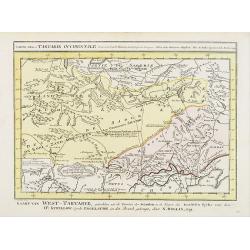
Carte de la Tartarie Occidentale.
Uncommon issue of this finely engraved map shows China's capital city of Peking, inland from the Gulf of Lyau-tong.The map locates in northeastern China to the border of ...
- $100 / ≈ €87
Date: Amsterdam, 1749
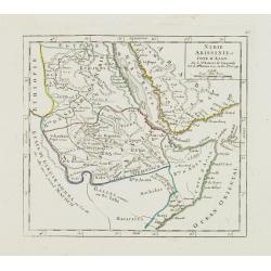
Nubie Abissinie et Cote d'Ajan.
Charming small map showing the Horn of Africa. Included are part of present-day Yemen and the coastline of Saudi Arabia along the Red Sea.From Atlas Portatif Universel, b...
- $100 / ≈ €87
Date: Paris, 1749
Tartariae Sinensis mappa geographica ex Tabulis specialibus RRPP Iesuitarun nec non Relationibus R.P. Gerbillon / per Dom d'Anville, . . . primum A° 1732 nunc se Nunc secundum LL. projectionis . . . descripta per Tobiam Mayer
A very attractive map of Korea and Manchuria on the mainland and two islands of 'Ezo' and Sakhalin, prepared by Jean-Baptiste Bourguignon d'Anville (1697-1782) and Johann...
- $750 / ≈ €655
Date: Nuremberg, 1749
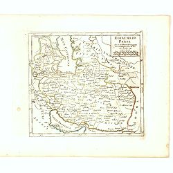
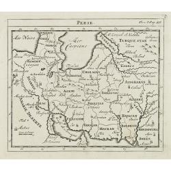
Royaume de Perse Par le Sr. Robert de Vaugondy fils de Mr. Robert Geog. Ord du Roi avec Privilege 1749.
Small detailed map of Persia. From Atlas Portatif Universel, by Robert de Vaugondy.Page 163 outside border top right. First and only state.
Date: Paris, 1749
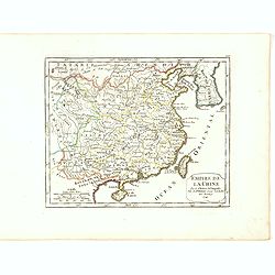
Empire de la Chine Par le Sr. Robert de Vaugondy fils de Mr. Robert Geog. Ord du Roi avec Privilege 1749.
Small detailed map of China, and Corea, including Taiwan. From Atlas Portatif Universel, by Robert de Vaugondy.Page 165 outside border top right. First and only state.The...
Date: Paris, 1749
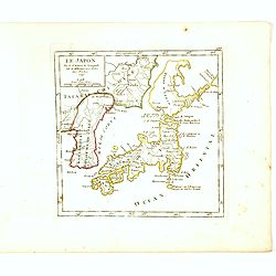
Le Japon Par le Sr. Robert de Vaugondy fils de Mr. Robert Geog. Ord du Roi avec Privilege 1749.
Small detailed map of Japan and Korea. From Atlas Portatif Universel, by Robert de Vaugondy.Page 168 outside border top right. First state. The map is of interest for the...
Date: Paris, 1749
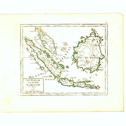
Les Isles de la Sonde Par le Sr. Robert de Vaugondy fils de Mr. Robert Geog. Ord du Roi avec Privilege 1749.
Small detailed map of of South East Asia, including Malaysian Peninsular with Singapore. From Atlas Portatif Universel, by Robert de Vaugondy.Page 170 outside border top...
Date: Paris, 1749
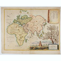
Afbeeldinge der Oude Waereld; Benevens Derzelver Verdeling Onder de Nakomelingen Noachs.
An interesting and uncommon map of the 'Old World' showing the continents of Europe, Asia, and Africa divided among Noah's sons. Engraved by Jan van Jagen and published i...
Date: Amsterdam, 1749
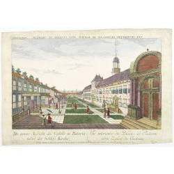
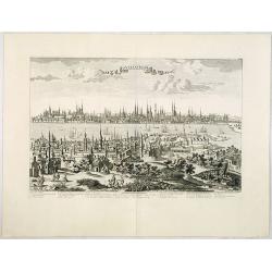
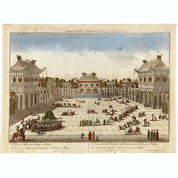
Die innere Aussicht des Castells in Batavia . . .
Showing the inside-square of the V.O.C. headquarters in Jakarta.The hand colored engraving is much perforated and the windows are cut out, a thin transparent paper is mou...
- $500 / ≈ €437
Date: Augsburg, 1750
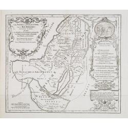
La Judée ou Palestine, sous le roi Herodes surnommé le grand, où sont la Judée, la Samarie, la Galilée, la Thrachonitide ou Iturée, la Perée et l'Idumée pour le nouveau testament et pour les livres des Machabées. . .
Scarce map of Palestine. Published by Pierre Moullart-Sanson, who was the grandson of Nicolas the elder.This is the uncommon third state. For the second state a large tit...
- $200 / ≈ €175
Date: Paris, ca.1750
Nieuwe kaart van Tartarie.
A map of Tartary, Korea and part of Japan. The map is most notable for the confusion between Kamchatka and Iesso. Hokaido labelled Compagnie LandFrom: Nieuwe en Beknopte ...
- $450 / ≈ €393
Date: Amsterdam 1750
Carte des Isles Kouriles.
A good impression of a detailed, finely engraved map of the north of Honshu. Derived from Russian maps resulting from the expeditions of Bering, Cherikov and others, one ...
- $300 / ≈ €262
Date: Paris, 1750

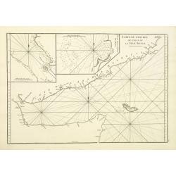
Manuscript map of the Bay of Nagasaki.
An extremely rare manuscript chart in brown ink and wash color on a printed sheet of paper with a system of rhumblines and latitude scales. This chart shows the Bay of Na...
Date: Amsterdam, 1750
Constantinople ville de Romanie et capitale de l'Empire des Turcs.
A very decorative and extremely rare of Istanbul, including a numbered legend in lower part. Published by Jacques Chéreau, (1688 - 1776). Engraved by Aveline and first ...
Date: Paris, ca.1750
Partie Orientale De L'Empire De Russie En Asie, ou trouvent les Provinces de Jakuckskoy, Kransnojarskoy, Selinginskoy, Ilimskoy, Krasnojarskoy, Narimskoy, Jenisseiskoy, Mangajeiskoy, & c. et les Confins de la Tatarie Chinoise. . . .1750
Map of the Northeastern portion of Asia, including Russia, China, the Gobi Desert, etc..
- $250 / ≈ €218
Date: Paris, 1750
Partie Orientale de l'Empire de Russie en Asie.. et les Confins de la Tatarie Chinoise. . .
Large map with mostly topographical detail of mountains, deserts, rivers and forests. Covers the region from Tomsk eastward and includes Sakhalin. Uncolored, decorative t...
- $300 / ≈ €262
Date: Paris, 1750
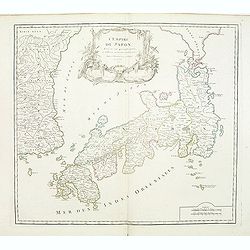
L'Empire du Japon divisé en sept principales parties. . .
Large map of Japan and Korea with a distinctively French style title cartouche containing two small landscapes.The map draws heavily on the previous work of Bellin, but i...
Date: Paris, 1750
Nieuwe kaart van Tartarie.
A map of Tartary, Korea and part of Japan. The map is most notable for the confusion between Kamchatka and Iesso.There are very good details of towns and trade routes in ...
Date: Amsterdam, 1750
Partie Orientale de l'Empire de Russie en Asie.. et les Confins de la Tatarie Chinoise. . .
Large map with mostly topographical detail of mountains, deserts, rivers and forests. Covers the region from Tomsk eastward and includes Sakhal from his "Atlas Unive...
- $120 / ≈ €105
Date: Paris, 1750
Partie Orientale de l'Empire de Russie en Asie.. et les Confins de la Tatarie Chinoise. . .
Large map with mostly topographical detail of mountains, deserts, rivers and forests. Covers the region from Tomsk eastward and includes Sakhal from his "Atlas Unive...
Date: Paris, 1750
Nouvelle Carte de L'Empire De La Chine et les Pais circonvoisins - Nieuwe Kaart van t Keizerryk China en de aangrensende Landen.
Finely engraved map of China and Korea, with titles in both French and Dutch.The map extends west to the Gobi Desert and Tibet and shows Macao and Canton, among other cit...
- $500 / ≈ €437
Date: Amsterdam, 1750
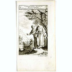
1. Seigneure Delassa tirés de Grueber. 2. Trophée à l'honneur du Grand Lama. (Tibet).
Fanciful European depiction of people from Tibet and Lhassa. A somewhat larger image appeared in "Abbe A.F. Prévost, Histoire Generale des Voyages".
Date: Paris, ca. 1750
Nouvelle Carte de L'Empire De La Chine et les Pais circonvoisins - Nieuwe Kaart van t Keizerryk China en de aangrensende Landen.
Finely engraved map of China and Korea, with titles in both French and Dutch.The map extends west to the Gobi Desert and Tibet and shows Macao and Canton, among other cit...
Date: Amsterdam, 1750
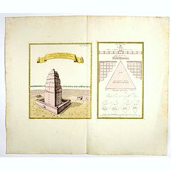
Totius Templi Beli et partis ubis Babylonicae prospectiva.
Two print on the same sheet, showing The Tower of Babe. The story of the city of Babel is recorded in Genesis 11:1–9. Everyone on earth once spoke the same language. As...
Date: Nuremberg, 1750
Nieuwe kaart van het Turksche Ryk gelegen in Europa, Asia en Afrika. . .
Attractive map of the Mediterranean and countries bordering, extending eastwards to include all the Arabian Peninsula.
- $700 / ≈ €611
Date: Amsterdam, 1750
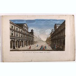
Vue du serail du grand Mogol, des Indes.
Optical print of a Mogul Palace in India. Probably published by or after Jacques Chereau, who was a well-known publisher of optical prints, established in rue St. Jacques...
- $200 / ≈ €175
Date: Paris, ca. 1750
Archipel des indes Orientales
A finely engraved map depicting South East Asia with very good detail on the Philippines. Decorative title cartouche. From Atlas Universel of Gilles and Didier Robert de ...
Date: Paris, 1750
Carte de L'Isle de Sumatra Dressee sur les Journaux des Navigateurs . . .
Detailed map of Sumatra and Malacca, centered on Singapore and including the southern portion of the Malaysian peninsula. With "Detroit de Sincapour" and severa...
Date: Paris, ca. 1750
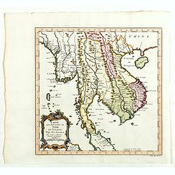
Carte des Royaumes de Siam, du Tunquin, Pegu, Ava, Aracan . . .
Map of Siam, du Tunquin, Pegu, Ava, Aracan. Across the top is an extensive list of 22 important sites and locations keyed to the plan with tiny letters and numbers.Jacque...
- $350 / ≈ €306
Date: Paris, 1750
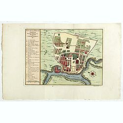
(Lopburi - Thailand) Plan de la ville de Louvo . . .
Early plan of Louvo city. The map shows a list of important buildings such as King Narai's Palace (Narai Ratcha Niwet), trading posts, pagodas, water reservoirs, gardens,...
Date: Paris, 1750
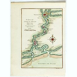
Carte du Cours du Menam . . .
Map of the Menam Riviera. Across the top is an extensive list of 22 important sites and locations keyed to the plan with tiny letters and numbers.Jacques Nicolas Bellin (...
- $200 / ≈ €175
Date: Paris, 1750
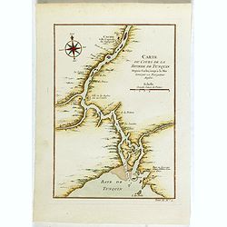
Carte du Cours de la riviere de Tunquin . . .
Map of the Tunquin Riviera. Across the top is an extensive list of 22 important sites and locations keyed to the plan with tiny letters and numbers.Jacques Nicolas Bellin...
- $200 / ≈ €175
Date: Paris, 1750
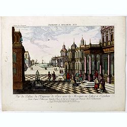
Vuë de la Cour de l'Empereur de Perse avec le diverses Habillements des Dames du premier Rang designe d'apres Nature par Quilielm Baur et fait en Estampe par François Xav. Habermann.
An optical print of the court of the Persian Emperor. Engraved by F.X. Habermann (1721-1796). The Academie Imperiale was a well-known publisher of optical prints, establi...
Date: Augsburg, 1750
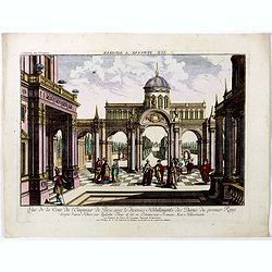
Vue du Pallais du l'Empereur de Perse avec la Mosquée, ou Eglise a Ispahan.
An optical print of the court of the Persian Emperor. Engraved by F.X. Habermann (1721-1796). The Academie Imperiale was a well-known publisher of optical prints, establi...
- $300 / ≈ €262
Date: Augsburg, 1750
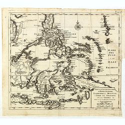
The Philippine Islands and others of the East Indies. . .
Herman Moll's 'busy' map of South East Asia and the Philippines, published in the middle of the eighteenth century in London. The map includes numerous small islands, Sum...
- $280 / ≈ €245
Date: London, ca 1750
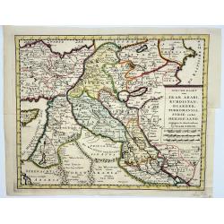
Irak, Arabi, Kurdistan, Diarbek, Turkomania, Syrie en het Heilige Land.
Isaak Tirion's map of the Near East. His 'Nieuwe en beknopte handatlas' saw 6 editions between before 1740 and after 1784. Also the 'Atlas van de Nederlandse Provintien' ...
- $350 / ≈ €306
Date: Amsterdam, ca. 1750
![[Lot of 13 prints of the Chinese court] Habillement de l' Empereur dela Chine & des Dames de son Palais aves quel...](/uploads/cache/IMG_0845-250x250.jpg)
[Lot of 13 prints of the Chinese court] Habillement de l' Empereur dela Chine & des Dames de son Palais aves quel...
Prints of the Chinese court.[Lot of 13 prints]- Salle Imperiale De L'Audience, tiree de Nieuhof (1760)- Pagodes ou Statues; Miniso ou la Volupté (1749- Pagodes ou sta...
- $400 / ≈ €349
Date: Amsterdam, c. 1750
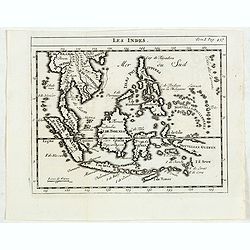
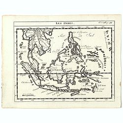
Les Indes.
Scarce small map of South East Asia with Indonesia, Thailand, Philippines and including New Guinee, based on cartography of Guillaume Delisle. Published in "Nouveau ...
- $125 / ≈ €109
Date: Paris, La veuve Lottin & Butard, P.G. Le Mercier, Rollin, 1751
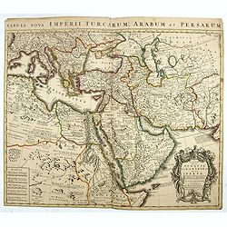
Carte de la Turquie de L'Arabie et de la Perse.
This is the Amsterdam issue of De L'Isle's map of the Turkish Empire and Arabian Peninsula. It includes the Turkish Empire, the Mediterranean, Central Asia, and parts of ...
Date: Amsterdam, 1751
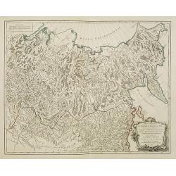
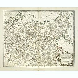
Partie Orientale de l'Empire de Russie en Asie.
Detailed map of the north-eastern part of Russia, including Siberia.
Date: Paris 1752
Carte Des Isles de Java, Sumatra, Borneo.. Malaca et Banca..
Jacques Nicolas Bellin (1703-1772) was one of the most important and proficient French cartographers of the mid-eighteenth century. He was appointed the first Ingenieur H...
- $300 / ≈ €262
Date: Paris, 1752
Perse.
Scarce small map of Persia based on cartography of Guillaume Delisle (. Published in "Nouveau traité de geographie par M ", published by La veuve Lottin & ...
Date: Paris, P.G. Le Mercier, 1752
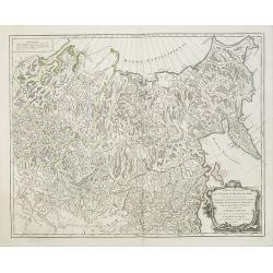
Partie Orientale de l'Empire de Russie en Asie.
Detailed map of the north-eastern part of Russia, including Siberia, Kamchatka, the island of Sakhalin.
- $200 / ≈ €175
Date: Paris, 1752
Les Indes.
A scarce small map of Southeast Asia, including Indonesia, Thailand, the Philippines, and New Guinea, based on the cartography of Guillaume Delisle. Published in "No...
- $200 / ≈ €175
Date: Paris, ca. 1752
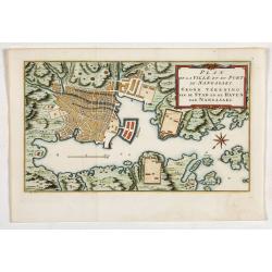
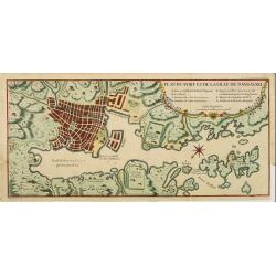
Plan de la Ville et du port de Nangasaki. Grond tékening van de stad en de haven van Nangasaki.
The map shows a plan of the port and the town of Nagasaki. Deshima, the place where the Dutch traders were allowed to settle, is included. From Prévost's important Colle...
- $300 / ≈ €262
Date: Amsterdam, 1752
Carte de L'entrée du Golfe de la Mer Rouge.
Chart of the Gulf of Aden with the coast line of Yemen, the Island Socotra and the entrance of the Red Sea. With 2 inset charts off-shore of the town Mocha.D'Après De Ma...
- $400 / ≈ €349
Date: Paris, 1753
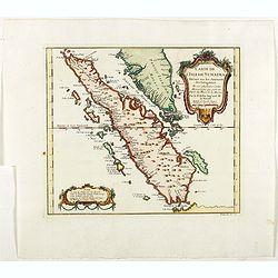
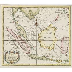
Carte de l'Isle de Sumatra. . . / Kaart van het Eiland Sumatra. . .
Map of Sumatra, also showing the tip of the Malay Peninsula and the Straits of Singapore. An unusually detailed map of the area, showing many coastal features, shoals, ba...
Date: The Hague, Pierre d'Hondt, 1753
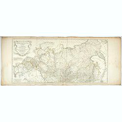
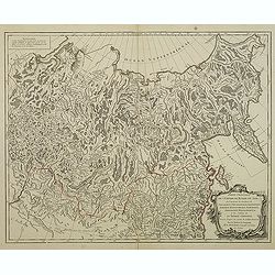
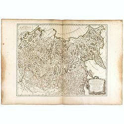
Troisième partie de la carte d'Asie, contenant la Sibérie, et quelques autres parties de la Tartarie. . .
Engraved map of Tartary on two sheets, with country boundaries in outline color. Includes geographic notes and ornamental cartouche by "H. Gravelot, invenit., DeLafo...
Date: Paris, 1753
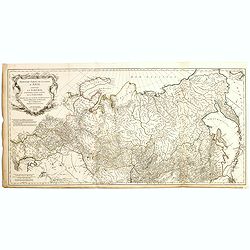
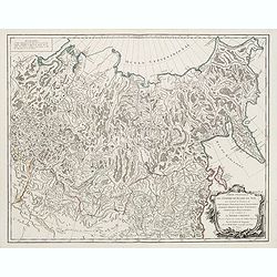
Troisième partie de la carte d'Asie, contenant la Sibérie, et quelques autres parties de la Tartarie. . .
Engraved map of Tartary on two sheets, with country boundaries in out line color. Includes geographic notes and ornamental cartouche by "H. Gravelot, invenit., DeLaf...
- $750 / ≈ €655
Date: Paris, 1754
Turquie Asiatique. Par le Sr. Robert Geog. Ord du Roi avec Privilege 1748.
Small detailed map of Turkey. From Atlas Portatif Universel, by Robert de Vaugondy.Page 161 outside border top right. First and only state.
Date: Paris, 1754
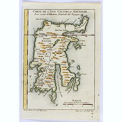
Carte de L'Isle Celebes ou Macassar.
A fine little copper engraved map of Celebes Island, Makassar.It is the provincial capital of South Sulawesi, Indonesia. It is the largest city on Sulawesi Island in term...
- $60 / ≈ €52
Date: Paris, 1754
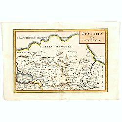
Scythia et Serica.
Covering the region between the Caspian and the Sea of China, much of which is Terra Incognita in the North and East. With title in upper right corner.To the east of the ...
Date: London, 1755
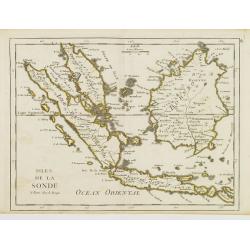
Isles de la Sonde.
Fine map of the islands of Java, Sumatra, Borneo, Bali and part of the Malay peninsular. George Louis Le Rouge was active from 1740- till 1780 as a publisher, and was app...
- $200 / ≈ €175
Date: Paris, 1756
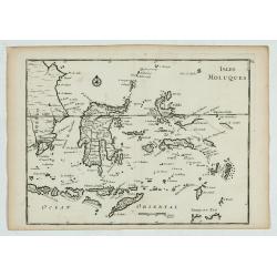
Isles Moluques.
A scarce little map depicting European knowledge of Sulawesi, part of Borneo and the Spice Islands at the time of publication.George Louis Le Rouge was active from 1740- ...
Date: Paris, 1756
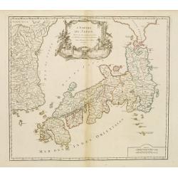
L'Empire du Japon..
Very similar to Joan Blaeu's map of 100 years previously: Europeans by then had been expelled, except the Dutch, whose movements were so curtailed that they were not able...
Date: Paris, 1756
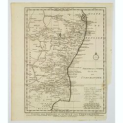
Toneel des Oorlogs op de Kust van Choromandel . . .
The detailed map refers to the Carnatic (or Karnatic) Wars (1746-1763), a series of military conflicts in the middle of the 18th century in India. These conflicts involve...
Date: Amsterdam, 1756
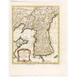
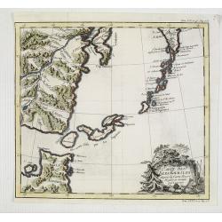
Carte de la province de Quan-tong, ou Lyau-tong et du Royaume de Kau-li ou Corée.
Map of Korea. The map is of interest for the use of East Sea, the sea between Korea and Japan, here called "Mer de Corée. With Seoul named, King-Ki-TaoDecorative ti...
Date: Paris, 1757
![[Lot of 6] Carte de la Baye d'Hocsieu. Fukin. (3 Maps + 3 Gravure of China)](/uploads/cache/IMG_2524-250x250.jpg)
[Lot of 6] Carte de la Baye d'Hocsieu. Fukin. (3 Maps + 3 Gravure of China)
[Lot of 6 items]. (3 Maps +3 gravure )- Carte de la Baye d'Hocsieu et des Entrees de la Riviere de Chang Situees dans la Province de Fokyen. J.N.Berlin 1748- Carte de l�...
Date: Amsterdam, 1759
Plan du port et de la ville de Nangasaki.
This plan originates from Charlevoix's work Histoire et description Générele du Japon . His first in 1715 published work was the Histoire de l'etablissement du christia...
- $600 / ≈ €524
Date: Paris, 1760
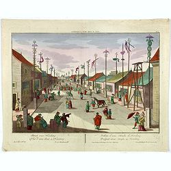
Vue d'une Rue Nanking.
A well-known publisher of optical prints, established in Augsburg. After a design by P.van Blankaert.In the eighteenth and nineteenth centuries, there were many popular s...
Date: Augsburg 1760
Karte von den Bengaslishen Meerbussen . . .
Manuscript map including Ceylon, south of India, Bengal gulf with Burma (Myanmar), Thailand and northern tip of Sumatra. Very decorative and colorful compass rose in cent...
Date: Germany, ca. 1760
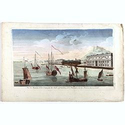
Vue des Magasins de la Compagnie des Indes à Pondichéry, de l'Amirauté et de la maison du Gouverneur.
Optical print of the French East India Company's warehouses, the Admiralty and the Governor's House at Pondicherry in Tamil Nadu. Pondicherry, on the Coromandel Coast sou...
- $300 / ≈ €262
Date: Paris, ca 1760
Le dedans du Palais de l'Empereur de Chine à Peking.
This so called optical print shows the imperial palace, the Forbidden City in Peking, China. In the foreground a large courtyard is depicted, surrounded by buildings. Thr...
Date: Augsburg, 1760
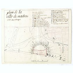
Plan de la ville de Madras et de ses attaques.
Manuscript map, in black, brown and red ink, showing the fortifications of the city of Madras, now Chennai, on the east coast of India, north of Pondicherry.Showing the c...
Date: Paris, ca 1760
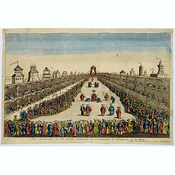
Vue perspective de la grande Ceremonie du Couronnement de l'Empereur de la Chine.
So-called optical print illustrating the crowning of the Chinese emperor. It shows the throne at the center.Mondhare was a well-known publisher of optical prints, establi...
- $450 / ≈ €393
Date: Paris, 1761
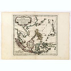
Les Isles de la Sonde, Moluques, Philippines, Carolines, et Marlannes.
Nice detailed map of southeast Asia, showing the Malay Peninsula, Sumatra, Java and the island of Borneo. Engraved by E. Dussy and the title cartouche by Arrivet. From hi...
- $275 / ≈ €240
Date: Paris, ca. 1762
Nuova et Accurata Carta dell' Isole Filippine, Ladrones, a Moluccos o Isole della Speziarie come anco Celebes &c.
The map has been prepared by Isaac Tirion for his Nieuwe en beknopte Handatlas (New and concise hand-atlas) of which Albrizzi made an imitation and used in the Italian ed...
- $400 / ≈ €349
Date: Venice, 1740-1762
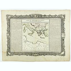
Suite de l'Histoire de Perse. Depuis l'An 3519, jusqu'à l'An 3525.
Showing eastern Europe centered on Greece, Macedonia, Persia and western Turkey. Textural information in French flanking the map. De Mornas was Geographer to Louis XVI, a...
- $60 / ≈ €52
Date: Paris, 1762
Histoire universelle depuis le commmencement du monde jusqu'a present. Tome Vingt-unieme. Portugais, Espagnols, Hollanois etc
Volume 21 of this informative publication with a description of the discoveries, conquests, and settlements by the Portuguese, Spaniards, English, and Dutch in Southeast ...
- $1200 / ≈ €1048
Date: Amsterdam, Leipzig, 1763
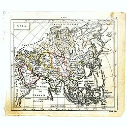
Asia.
Uncommon miniature map of Asia. The map is of interest for the use of Sea of Corea, for the sea between Korea and Japan.Engraved by J.Ellis for "A New General and Un...
- $150 / ≈ €131
Date: London, 1761-1763
![East Indies. {India]](/uploads/cache/38623-250x250.jpg)
East Indies. {India]
Uncommon miniature map of India, engraved by Thomas Kitching for "A New General and Universal Atlas Containing Forty five Maps by Andrew Dury".This miniature at...
- $100 / ≈ €87
Date: London, 1761-1763
