Browse Listings in America > South America
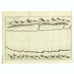
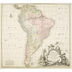
I. S. Sebastien.
Simplified bird's-eye view of Ilha de São Sebastiao, part of an archipelago off the southern coast of Brazil 210 miles from Rio de Janeiro. It was discovered on January ...
- $225 / ≈ €197
Date: Amsterdam, E. Roger, 1703
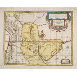
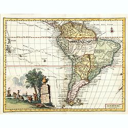
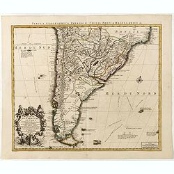
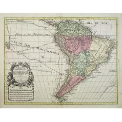
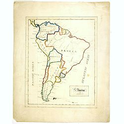
Paraguay o Prov. De Rio De La Plata cum regionibus adiacentibus Tucuman et Sta. Cruz De la Sierra.
An attractive map centered on Paraguay. Title cartouche on the upper right-hand corner, on the ocean a ship and a sea monster are depicted.
- $300 / ≈ €262
Date: Amsterdam, 1708
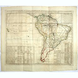
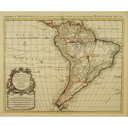
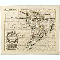
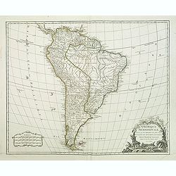
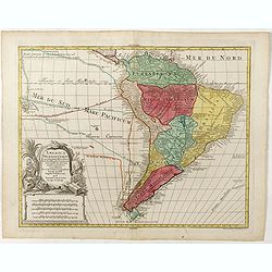
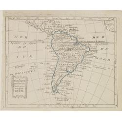
Nouvelle carte de geographie de .. Meridionale de l'Amerique
Chatelain's map of South America. The title is in two lines across the map. The tracks of Magellan, de la Maire, de Mendana, etc. are shown.On each side, borders appear a...
- $250 / ≈ €218
Date: Amsterdam, 1719
Isle du Prince.
Simplified bird's-eye view of "Isle du Prince" in present-day Argentina.From volume two of the French reissue of the account of early Dutch voyages. The French ...
- $75 / ≈ €66
Date: Amsterdam, F. Bernard, 1725
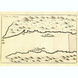
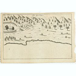
Porto il Desire.
Simplified bird's-eye view of Port Desire or Puerto Deseado in present-day Argentina.From volume two of the French reissue of the account of early Dutch voyages. The Fren...
- $150 / ≈ €131
Date: Amsterdam, F. Bernard, 1725
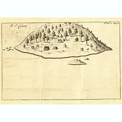
I. S. Clara.
Island "S. Clara" in Brazil just a few degrees north of the Tropic of Capricorn.From volume two of the French reissue of the account of early Dutch voyages. The...
- $100 / ≈ €87
Date: Amsterdam, F. Bernard, 1725
![[þLot of 2 maps of South America] Carte de la Terre Ferme, du Perou, du Bresil, et du Pays des Amazones. . . [together with] Carte du Paraguai, du Chili...](/uploads/cache/48132-250x250.jpg)
[þLot of 2 maps of South America] Carte de la Terre Ferme, du Perou, du Bresil, et du Pays des Amazones. . . [together with] Carte du Paraguai, du Chili...
SET OF TWO MAPS: A handsome pair of maps that together make up South America. The first map is a northern part of America based on cartography by Guillaume Delisle.Fill...
Date: Amsterdam, 1728
Carta geografica della america meridionale.
Uncommon map of South America based upon Guillaume De L'Isle's map. Includes the routes of early explorers in the Pacific, including Magellan, Drake, Le Maire, Mendana, V...
Date: Venice, 1740
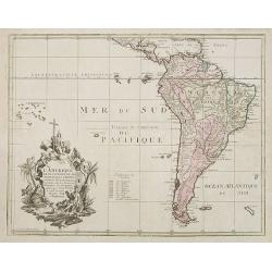
L'Amerique Meridionale Dressée sur les Observations..
Detailed map of South America prepared by De L'Isle, with fine title cartouche.The map is from a Dutch edition of De L'Isle's work entitled, Atlas Nouveau, Contenant Tout...
- $500 / ≈ €437
Date: Amsterdam c. 1745
Carte du Paraguay, du Chili, du Detroit de Magellan &c.
Large handsome map of the southern part of the continent with good interior detail for the period. The route of 18th century explorations are shown along with notations c...
Date: Amsterdam c. 1745
L'Amerique Meridionale Dressée sur les Observations . . .
Detailed map of South America prepared by De L'Isle, with fine title cartouche.
Date: Amsterdam, ca. 1745
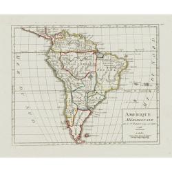
Amérique Méridionale.
Nice small map of South America. Dated 1748. From Atlas Portatif Universel, by Robert de Vaugondy.Page 105 outside border top right. Mary Sponberg Pedley does not mention...
- $75 / ≈ €66
Date: Paris, later than 1748
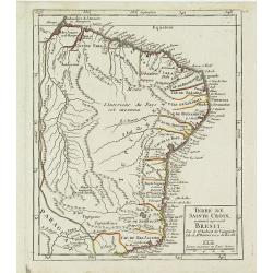
Terre de Sainte Croix, nommée à présent Bresil.
Detailed small map showing most part of the Brazilian seacoasts, from the mouth of the Amazon River as far as the island of Sao Sebastiao.From Atlas Portatif Universel, b...
- $75 / ≈ €66
Date: Paris, later than 1749
Amerique méridionale. . .
Detailled map of South America from his "Atlas Universel".Gilles Robert de Vaugondy (1688–1766), also known as Le Sieur or Monsieur Robert, and his son, Didie...
- $150 / ≈ €131
Date: Paris, 1750
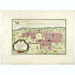
Plan de la ville de Buenos-Ayres.
Early plan of Buenos-Ayres city. Across the top is an extensive list of 22 important sites and locations keyed to the plan with tiny letters and numbers.Jacques Nicolaas ...
- $300 / ≈ €262
Date: Paris, 1750
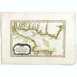
Carte de La Riviere de la Plata . . .
Map of La Plata Riviera. Across the top is an extensive list of 22 important sites and locations keyed to the plan with tiny letters and numbers.Jacques Nicolas Bellin (1...
- $350 / ≈ €306
Date: Paris, 1750
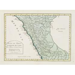
Suite de Perou Audience de Lima.
Uncommon edition of this accurate map showing the southern Peruvian coast, the ranges and villages of numerous Indian tribes are shown.FromAtlas Portatif pour servir a l'...
Date: Amsterdam, 1756
L'amerique meridionale dressee sur les memoires le plus recens. . .
Rare and decorative map of South America with good detail and interesting notations concerning the explorations of the interior. With in the lower right corner a title ca...
- $550 / ≈ €480
Date: Amsterdam, 1757
America Meridionalis.
This is the more scarce edition with the title cartouche lower left surrounded by Neptune and a native Indian.A rather accurate depiction and descriptions of South Americ...
- $550 / ≈ €480
Date: Augsburg, c. 1760
America Meridionalis.
The title cartouche lower left surrounded by native Indians and an Elephant.A rather accurate depiction and descriptions of South America. Brazil is slightly enlarged and...
Date: Augsburg, c. 1760
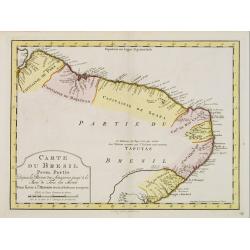
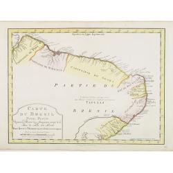
Carte du Bresil Prem.Partie...
Uncommon edition of this accurate map of the eastern part of Brazil.From Atlas Portatif pour servir a l'intelligence de l'Histoire Philosophique et Politique des etabliss...
- $100 / ≈ €87
Date: Amsterdam, 1773
Carte du Bresil Prem. Partie..
Uncommon edition of this accurate map of eastern part of Brazil. In lower right engraved 29a.From Atlas Portatif pour servir a l''''intelligence de l''''Histoire Philosop...
Date: Amsterdam, 1773
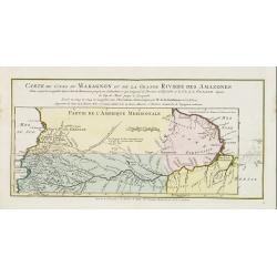
Carte du Cours du Maragnon ou .. Amazones..
Uncommon edition of this map of the river Amazon. In lower right engraved "30."From Atlas Portatif pour servir a l'intelligence de l'Histoire Philosophique et P...
Date: Amsterdam, 1773
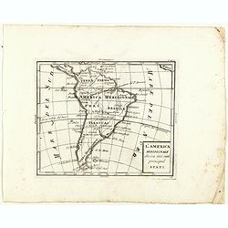
L'America meridionale divisa nei suoi principali stati.
Rare map of south America, from "Atlante Novissimo ad uso Dei Giovani Studiosi Contenuto In Carte XXVII.", published by Giovanni Zempel in Rome, ca. 1780.The ma...
- $100 / ≈ €87
Date: Rome, 1780
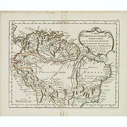
Carte du Bresil le Perou. . .
Scarce map of Northern part of South America with Venezuela, Colombia, Brazil and Peru, prepared by Nolin and published by L.J. Mondhare for his Atlas Général a l'usage...
- $125 / ≈ €109
Date: Paris, 1781
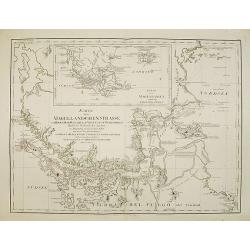
Karte der Magellanischen-Strasse. . .
Very detailed map of Strait of Magellan, with in top inset map of Southern tip of South America with the Falklands. Prepared by Don Juan de La Cruz of Spain.Engraved by J...
- $600 / ≈ €524
Date: Vienna, 1789
L'Amerique selon l'Etendue de Ses Principales Parties et don't les Points Principaux. . .
Uncommon map of South America, decorated with an elaborate cartouche referring to the conversion of the natives to Christianity, with natives bowing to a figure holding a...
Date: Augsburg, ca. 1790
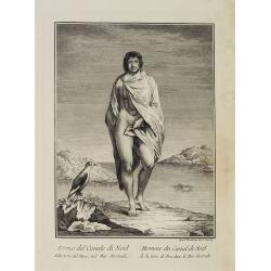
Uomo del Canale di Noël della terra del Fuoco, nel Mar Australe. / Homme du Canal de Noël de la terre de Feu dans la Mer Australe.
Full portrait of a man from Christmas Sound, in Tierra del Fuego This engraved print on laid paper is from "Raccolta di stampe," a series of historically sign...
Date: Venice, Antonio Zatta, c.1790
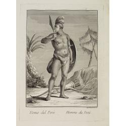
Uomo del Perù. / Homme du Perou.
Full portrait of a Peruvian warrior. From “Raccolta di … stampe.” a series of historically significant eighteenth-century copper plate engravings by Venetian engrav...
Date: Venice, Antonio Zatta, c.1790
L'Amérique Méridionale, Divisée en ses Principaux Etats.
Map of South America, from Atlas de la Géographie de toutes les parties du monde .. Ouvrage destiné pour l'education, et nécessaire aux négocians, aux voyageurs, aux ...
Date: Paris, Prudhomme, Levrault, Debray, 1806
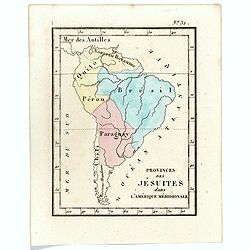
Prvinces des Jésuites dans l'Amerique méridionale.
Rare map of South America from "Atlas Universel indiquant les établissemens des Jésuites: avec la manière dont ils divisent la terre, suivi desévénemens remarqu...
- $200 / ≈ €175
Date: Paris, Ambroise Dupont , 1826
![[The Callo Palace ].](/uploads/cache/27288-250x250.jpg)
[The Callo Palace ].
Aquatint depicting Peruvian Inca Palace called Callo.Engraved by Fumagalli.From Giulio Ferrario's work Le Costume Ancien et Moderne ou Histoire du gouvernement, de la mil...
- $80 / ≈ €70
Date: Milan, 1827
![[The Callo Palace.]](/uploads/cache/27289-250x250.jpg)
[The Callo Palace.]
Aquatint depicting upper portion of print an Inca Palace near Cannar in the province of Quito in Peru. Bottom portion a plan of the palace (70 x 160).Engraved by Fumagall...
- $80 / ≈ €70
Date: Milan, 1827
![[Spanish Sheppard's in Paraguay ].](/uploads/cache/27290-250x250.jpg)
[Spanish Sheppard's in Paraguay ].
Aquatint depicting Spanish Sheppard's in Paraguay.Engraved by Gallina.From Giulio Ferrario's work Le Costume Ancien et Moderne ou Histoire du gouvernement, de la milice, ...
- $50 / ≈ €44
Date: Milan, 1827
![[ The circular fortress of Cannar, Peru. ]](/uploads/cache/27292-250x250.jpg)
[ The circular fortress of Cannar, Peru. ]
Aquatint depicting the circular fortress of Cannar, Peru.Engraved by Fumagalli.From Giulio Ferrario's work Le Costume Ancien et Moderne ou Histoire du gouvernement, de la...
- $80 / ≈ €70
Date: Milan, 1827
![[ Fortresss of Cannar in Quito Peru ].](/uploads/cache/27293-250x250.jpg)
[ Fortresss of Cannar in Quito Peru ].
Aquatint depicting the fortress of Cannar in Quito Peru inspired by a print from atlas by Alexander Von Humboldt.Engraved by E. F.From Giulio Ferrario's work Le Costume A...
- $80 / ≈ €70
Date: Milan, 1827
![[ Santiago inhabitants in their local dress. ]](/uploads/cache/27294-250x250.jpg)
[ Santiago inhabitants in their local dress. ]
Aquatint depicting inhabitants of Santiago in local dress.Engraved by Gallina.From Giulio Ferrario's work Le Costume Ancien et Moderne ou Histoire du gouvernement, de la ...
- $50 / ≈ €44
Date: Milan, 1827
![[ Guayanas inhabitants Paraguay ].](/uploads/cache/27295-250x250.jpg)
[ Guayanas inhabitants Paraguay ].
Aquatint depicting some relexing Guayanas Indians of Paraguay, who occupy the rivers flowing to the right bank of the Parana.The Charruas Indians were the first inhabitan...
- $50 / ≈ €44
Date: Milan, 1827
![[ Charruas Indians from Paraguay ].](/uploads/cache/27296-250x250.jpg)
[ Charruas Indians from Paraguay ].
Aquatint depicting the Charruas Indians cooking. The charruas Indians were the first inhabitants who hunted and fished in the area now known as Uruguay. They have probabl...
- $60 / ≈ €52
Date: Milan, 1827
![[ Indians playing Queciu (top) and Porotos (bottom) ].](/uploads/cache/27298-250x250.jpg)
[ Indians playing Queciu (top) and Porotos (bottom) ].
Aquatint depicting Indians playing Queciu (top) and Porotos (bottom).Engraved by Fumagalli.From Giulio Ferrario's work Le Costume Ancien et Moderne ou Histoire du gouvern...
- $50 / ≈ €44
Date: Milan, 1827
![[ Chilean indians playing ciueca ].](/uploads/cache/27299-250x250.jpg)
[ Chilean indians playing ciueca ].
Aquatint depicting Chilean indians playing "ciueca", a native hockey-like game.Engraved by Fumagalli.From Giulio Ferrario's work Le Costume Ancien et Moderne ou...
- $75 / ≈ €66
Date: Milan, 1827
![[Jesuitical Indians at work at their 'Reducciones' ]](/uploads/cache/27300-250x250.jpg)
[Jesuitical Indians at work at their 'Reducciones' ]
Aquatint depicting Jesuitical Indians in Paraguay. The Jesuit Missions or "Reducciones" functioned like small independent "republics" and lived in com...
- $80 / ≈ €70
Date: Milan, 1827
![[Araucani chief and his entourage from Chile ].](/uploads/cache/27302-250x250.jpg)
[Araucani chief and his entourage from Chile ].
Aquatint depicting an Araucani chief and his entourage. They were known as the toughest indigenous people of South America. The Araucans are Amerindian tribes habiting th...
- $85 / ≈ €74
Date: Milan, 1827
![[Indians of Patagonia, Chile, greeting a European traveller, probably Louis Antoine de Bougainville. ]](/uploads/cache/27303-250x250.jpg)
[Indians of Patagonia, Chile, greeting a European traveller, probably Louis Antoine de Bougainville. ]
Aquatint depicting Indians of Patagonia, Chile, greeting a European traveller, probably Louis Antoine de Bougainville. Comte de Bougainville was a French admiral and expl...
- $75 / ≈ €66
Date: Milan, 1827
![[Yacanacus inhabitants of Tierra del Fuego ].](/uploads/cache/27304-250x250.jpg)
[Yacanacus inhabitants of Tierra del Fuego ].
Aquatint depicting Yacanacus natives of Tierra del Fuego.Engraved by Gallina.From Giulio Ferrario's work Le Costume Ancien et Moderne ou Histoire du gouvernement, de la m...
- $100 / ≈ €87
Date: Milan, 1827
![[Birds from Brazil ].](/uploads/cache/27307-250x250.jpg)
[Birds from Brazil ].
Aquatint depicting 6 different species of birds from Brazil. Engraved by Raineri.From Giulio Ferrario's work Le Costume Ancien et Moderne ou Histoire du gouvernement, de ...
- $75 / ≈ €66
Date: Milan, 1827
![[Coroados artifacts from Brazil ].](/uploads/cache/27309-250x250.jpg)
[Coroados artifacts from Brazil ].
Aquatint depicting artifacts used by the Coroados tribe of Brazil.Engraved by Fumagalli.From Giulio Ferrario's work Le Costume Ancien et Moderne ou Histoire du gouverneme...
- $80 / ≈ €70
Date: Milan, 1827
![[Camacan indians in Brazil ].](/uploads/cache/27312-250x250.jpg)
[Camacan indians in Brazil ].
Aquatint depicting the Camacan indians in the Amazonian forest.Engraved by Fumagalli.From Giulio Ferrario's work Le Costume Ancien et Moderne ou Histoire du gouvernement,...
- $70 / ≈ €61
Date: Milan, 1827
![[Camacani Indian artifacts ].](/uploads/cache/27316-250x250.jpg)
[Camacani Indian artifacts ].
Aquatint depicting Camacani Indian artifacts.Engraved by Gallina.From Giulio Ferrario's work Le Costume Ancien et Moderne ou Histoire du gouvernement, de la milice, de la...
- $75 / ≈ €66
Date: Milan, 1827
![[Patacho Tribesmen of the Rio do Prado. ]](/uploads/cache/27317-250x250.jpg)
[Patacho Tribesmen of the Rio do Prado. ]
A native Patacho Tribesman is about to cut open a piece of fruit (melon?) with a hatchet while another holds a bow and arrows or spears while looking on. Behind them are ...
- $60 / ≈ €52
Date: Milan, 1827
![[Botocudos tribe artifacts ].](/uploads/cache/27318-250x250.jpg)
[Botocudos tribe artifacts ].
Aquatint depicting artifacts from the Botocudos tribel.Engraved by Gallina.From Giulio Ferrario's work Le Costume Ancien et Moderne ou Histoire du gouvernement, de la mil...
- $60 / ≈ €52
Date: Milan, 1827
![[Botocudos tribe of the Rio Grande, Paraguay ].](/uploads/cache/27320-250x250.jpg)
[Botocudos tribe of the Rio Grande, Paraguay ].
Aquatint depicting Botocudos tribe of the Rio Grande in Paraguay.Botocudo (from Portuguese for botoque, a plug, in allusion, to the wooden disks or plugs worn in their li...
- $120 / ≈ €105
Date: Milan, 1827
![[ Pampas Indians near Buenos Aires in Argentina ].](/uploads/cache/27322-250x250.jpg)
[ Pampas Indians near Buenos Aires in Argentina ].
Aquatint depicting the Pampas Indians in front of a local shop near Buenos Aires.Engraved by Bonatti.From Giulio Ferrario's work Le Costume Ancien et Moderne ou Histoire ...
- $100 / ≈ €87
Date: Milan, 1827
![[Gauchos near Buenos Aires in Argentina ].](/uploads/cache/27323-250x250.jpg)
[Gauchos near Buenos Aires in Argentina ].
Aquatint depicting some Gauchos cooking and relaxing near Buenos Aires. Engraved by Bonatti.From Giulio Ferrario's work Le Costume Ancien et Moderne ou Histoire du gouv...
- $75 / ≈ €66
Date: Milan, 1827
![[ Soldiers near the river banks of the River Plate ].](/uploads/cache/27324-250x250.jpg)
[ Soldiers near the river banks of the River Plate ].
Aquatint depicting soldiers living near the river banks of the River Plate, an estuary formed by a combination of Uruguay rivers and the Parana River. It is located at th...
- $75 / ≈ €66
Date: Milan, 1827
![[ A square at Buenos Aires. ]](/uploads/cache/27329-250x250.jpg)
[ A square at Buenos Aires. ]
Aquatint depicting a suare at Buenos Aires.Engraved by Fumigalli.From Giulio Ferrario's work Le Costume Ancien et Moderne ou Histoire du gouvernement, de la milice, de la...
- $75 / ≈ €66
Date: Milan, 1827
![[ Market Place at Buenos Aires. ]](/uploads/cache/27330-250x250.jpg)
[ Market Place at Buenos Aires. ]
Aquatint depicting a lifely scene of the Market Place Buenos Aires with its merchants.Engraved by Fumigalli.From Giulio Ferrario's work Le Costume Ancien et Moderne ou Hi...
- $75 / ≈ €66
Date: Milan, 1827
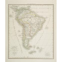
Amérique Méridionale . . .
Detailed map of South America, prepared by A. H. Basset, rue Saint-Jacques, no. 64, Paris and published in Atlas classique et Universel de Géographie . . . .The engraver...
- $100 / ≈ €87
Date: Paris, A.H. Basset, 1828
Carta esférica del Rio de la Plata : desde su embocadura hasta Buenos Aires.
Large nautical chart illustrating the estuary formed by the combination of the Uruguay River and the Paraná River. It forms part of the border between Argentina and Ur...
Date: Madrid, 1812-1838
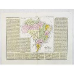
Impero Brasiliano . . .
A rare and detailed double-page map of Brazil. Map is surrounded by an explanatory historical text about the countries in a yellow background color.According to the title...
- $100 / ≈ €87
Date: Venice, 1840
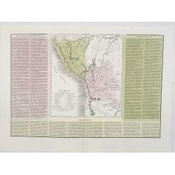
Le due Repubbliche . . . la Confederazione Peruviana . . . Bolivia . . .
A rare and detailed double-page map of Peru and Bolivia. Map is surrounded by an explanatory historical text about the countries in pink, yellow and green background colo...
- $100 / ≈ €87
Date: Venice, 1840
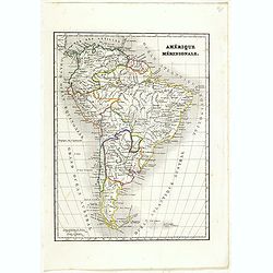
Amérique méridionale.
Detailed map of South America, prepared by Charles V. Monin (fl.1830-1880) a French cartographer of Caen and Paris. Published in Atlas Universel de Géographie Ancienne &...
- $45 / ≈ €39
Date: Paris, 1845
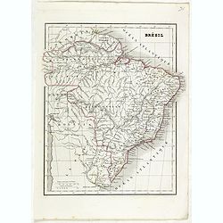
Brésil.
Detailed map of Brazil, prepared by Charles V. Monin (fl.1830-1880) a French cartographer of Caen and Paris. Published in Atlas Universel de Géographie Ancienne &c M...
- $45 / ≈ €39
Date: Paris, 1845
Pérou et Bolivia.
Detailed map of Peru and Bolivia, prepared by Charles V. Monin (fl.1830-1880) a French cartographer of Caen and Paris. Published in Atlas Universel de Géographie Ancienn...
- $45 / ≈ €39
Date: Paris, 1845
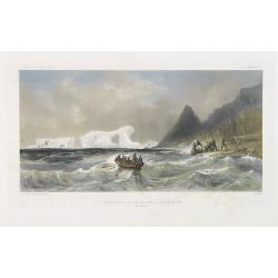
Débarquement sur les iles Powell, le 20 février 1838.
Exquisite contemporary colored lithograph of the Powell islands, situated near the South Orkney Islands, with Dumont D'Urville's officers leaving the island. Drawn by Lou...
- $400 / ≈ €349
Date: Paris, 1848
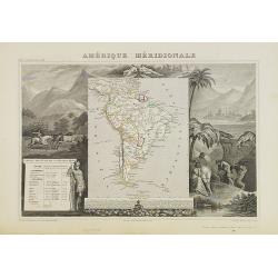
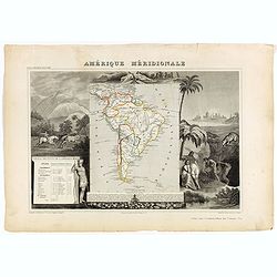
Amérique Méridionale.
A very decorative 19th century map of the continent colored to show political divisions. The map is surrounded by steel engraved scenes including horses, Indians, mining ...
Date: Paris, c. 1850
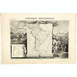
Amerique Meridionale.
A very decorative 19th century map of the continent colored to show political divisions. The map is surrounded by fully colored, steel engraved scenes including horses, I...
- $150 / ≈ €131
Date: Paris, 1850
(Album Pallière. Escenas Americanas. Reduccion de Cuadros, aquarelles y bosquejos.)
51 (of 52 )beautifully lithographed plates on tinted ground, lithographed by J. Pelvilain after designs by Juan Léon Palliere. One plate missing : santiagueña tejiendo ...
- $10000 / ≈ €8736
Date: Buenos Aires, en venta en la casa de los S.res Fusoni H.nos, ca. 1850
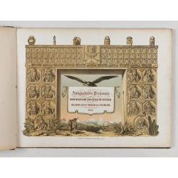
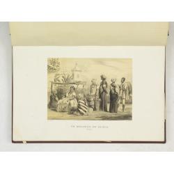
Antiguedades Peruanas (Atlas).
Atlas illustrated with 60 chromolithographic and tinted lithograph plates including illustrated title page.This atlas volume was produced to accompany a landmark collabor...
Date: Vienna (Austria), 1851
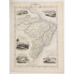
Brazil.
A highly decorative and detailed map of Brazil which was drawn and engraved by J. Rapkin (vignettes by H. Winkles & W. Lacey ).Showing Boats on Lake Negro, Monte Vide...
- $100 / ≈ €87
Date: London, Edinburgh & Dublin 1851
Amérique Méridionale.
Map of South America.Lovely map from one of the last decorative atlases of the nineteenth century.The rather simple map is framed by horses, Indians, jaguars, tapirs, and...
Date: Paris, A. Combette, 1852
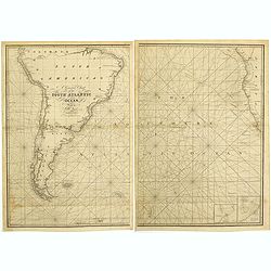
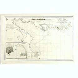
A general chart of the South Atlantic Ocean Drawn by J.W.Norie hydrographer. Revised & Corrected 1854.
A 2-sheet chart of the South Atlantic Ocean, showing the coast of South America from the mouth of the Amazon to Quito in Peru. The right hand part showing Africa's coast ...
- $600 / ≈ €524
Date: London, 1854
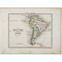
Nuovo Mondo parte Meridionale.
Uncommon map of South America prepared by Francesco Costantino Marmocchi. Above the map "Geografia Commerciale". From "Il Globo Atlante di carte Geografich...
Date: Genova, Paolo Rivara fu Giacomo, 1858
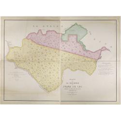
Plano de la Hacienda de Juana de Oro.
Wall-map sized map in 2 sheets, if joined 940 x 1300mm., showing the Hacienda (farm) of Juana de Oro in Ecuador. The cocoa farm was owned by Mrs. Leonor Carbo of Higgins ...
Date: Guayaquil ( Equateur), 1868
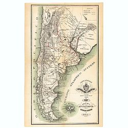
Carte générale de la République Argentine dressée d'après les données les plus récentes.
An UpToDate map of the Argentinian Republic published in Basel by "le Bureau Officiel d'Information de la République Argentine". Detailed map of Argentina show...
- $350 / ≈ €306
Date: Basel, 1887
![[South America].](/uploads/cache/46140-250x250.jpg)
[South America].
Alexey Afinogenovich Ilyin was a lieutenant general and cartographer (1832-1889). In 1856, after graduating from the Academy of the General Staff, he was at the military ...
- $100 / ≈ €87
Date: St. Petersburg, 1899
S America by Mas T.J. Sackels.
Pen and ink on card board. Map of South America drawn by T.J.Shackels. Probably a school exercise.
- $120 / ≈ €105
Date: England, ca. 1900
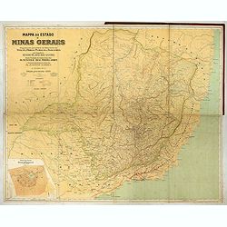
Mappa do estado de Minas Geraes.
Monumental map of the Minas Geraes State, the Brazilian Eldorado, with an inset plan of Belo Horizonte. Scale of 1 : 100 000. Lith. Hartmann-Reichenbach, 1910. Organized ...
- $1000 / ≈ €874
Date: Rio de Janeiro, 1910 -1911
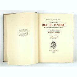
Cidade do Rio de Janeiro - Remodelação, Extensão e Embelezamento.
Important architectural book prepared by Antonio Prado Junior (1880-1955) under the general direction of Alfredo Agache ( 1875-1959) published by Foyer Brésilien editor,...
- $1100 / ≈ €961
Date: Foyer Brésilien editor, Paris, 1930
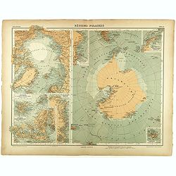
Régions Polaires.
Eight maps on one sheet, showing the North and South Poles, with adjective regions. Taken from "Atlas Universel" by Chesneau and Ch. Bonnesseur. Engraved by R. ...
- $50 / ≈ €44
Date: Paris, 1931
