Browse Listings in America > South America

177 listings found. Showing results 161 to 177
Débarquement sur les iles Powell, le 20 février 1838.

Exquisite contemporary colored lithograph of the Powell islands, situated near the South Orkney Islands, with Dumont D'Urville's officers leaving the island. Drawn by Lou...

$400 / ≈ €352
Maker / Publisher: DUMONT D'URVILLE, J.
Place & Date: Paris, 1848


Amérique Méridionale.

A very decorative 19th century map of the continent colored to show political divisions. The map is surrounded by steel engraved scenes including horses, Indians, mining ...

$150 / ≈ €132
Maker / Publisher: LEVASSEUR, V.
Place & Date: Paris, c. 1850


Amerique Meridionale.

A very decorative 19th century map of the continent colored to show political divisions. The map is surrounded by fully colored, steel engraved scenes including horses, I...

$150 / ≈ €132
Maker / Publisher: LEVASSEUR, V.
Place & Date: Paris, 1850


(Album Pallière. Escenas Americanas. Reduccion de Cuadros, aquarelles y bosquejos.)

51 (of 52 )beautifully lithographed plates on tinted ground, lithographed by J. Pelvilain after designs by Juan Léon Palliere. One plate missing : santiagueña tejiendo ...

$10000 / ≈ €8805
Maker / Publisher: PALLIERE, Jean Léon.
Place & Date: Buenos Aires, en venta en la casa de los S.res Fusoni H.nos, ca. 1850


Antiguedades Peruanas (Atlas).

Atlas illustrated with 60 chromolithographic and tinted lithograph plates including illustrated title page.This atlas volume was produced to accompany a landmark collabor...

$2200 / ≈ €1937
Maker / Publisher: DE RIVERO, Mariano Eduardo and VON TSCHUDI, Jakob.
Place & Date: Vienna (Austria), 1851


Amérique Méridionale.

Map of South America.Lovely map from one of the last decorative atlases of the nineteenth century.The rather simple map is framed by horses, Indians, jaguars, tapirs, and...

$90 / ≈ €79
Maker / Publisher: LEVASSEUR, V.
Place & Date: Paris, A. Combette, 1852


A general chart of the South Atlantic Ocean Drawn by J.W.Norie hydrographer. Revised & Corrected 1854.

A 2-sheet chart of the South Atlantic Ocean, showing the coast of South America from the mouth of the Amazon to Quito in Peru. The right hand part showing Africa's coast ...

$600 / ≈ €528
Maker / Publisher: NORIE, J.W.
Place & Date: London, 1854


Nuovo Mondo parte Meridionale.

Uncommon map of South America prepared by Francesco Costantino Marmocchi. Above the map "Geografia Commerciale". From "Il Globo Atlante di carte Geografich...

$75 / ≈ €66
Maker / Publisher: MARMOCCHI, F.C.
Place & Date: Genova, Paolo Rivara fu Giacomo, 1858


Plano de la Hacienda de Juana de Oro.

Wall-map sized map in 2 sheets, if joined 940 x 1300mm., showing the Hacienda (farm) of Juana de Oro in Ecuador. The cocoa farm was owned by Mrs. Leonor Carbo of Higgins ...

$500 / ≈ €440
Maker / Publisher: DILLON, A.
Place & Date: Guayaquil ( Equateur), 1868


Carte générale de la République Argentine dressée d'après les données les plus récentes.

An UpToDate map of the Argentinian Republic published in Basel by "le Bureau Officiel d'Information de la République Argentine". Detailed map of Argentina show...

$350 / ≈ €308
Maker / Publisher: BUREAU OFFICIEL D'INFORMATION DE LA REPUBLIQUE D'A
Place & Date: Basel, 1887


[South America].

Alexey Afinogenovich Ilyin was a lieutenant general and cartographer (1832-1889). In 1856, after graduating from the Academy of the General Staff, he was at the military ...

$100 / ≈ €88
Maker / Publisher: ILYIN, A.
Place & Date: St. Petersburg, 1899


S America by Mas T.J. Sackels.

Pen and ink on card board. Map of South America drawn by T.J.Shackels. Probably a school exercise.

$120 / ≈ €106
Maker / Publisher: SACKELS, T.J.
Place & Date: England, ca. 1900


Mappa do estado de Minas Geraes.

Monumental map of the Minas Geraes State, the Brazilian Eldorado, with an inset plan of Belo Horizonte. Scale of 1 : 100 000. Lith. Hartmann-Reichenbach, 1910. Organized ...

$1000 / ≈ €880
Maker / Publisher: DOS SANTOS, B-J.
Place & Date: Rio de Janeiro, 1910 -1911


Cidade do Rio de Janeiro - Remodelação, Extensão e Embelezamento.

Important architectural book prepared by Antonio Prado Junior (1880-1955) under the general direction of Alfredo Agache ( 1875-1959) published by Foyer Brésilien editor,...

$1100 / ≈ €969
Maker / Publisher: A. PRADO JUNIOR. / A.AGACHE
Place & Date: Foyer Brésilien editor, Paris, 1930


Régions Polaires.

Eight maps on one sheet, showing the North and South Poles, with adjective regions. Taken from "Atlas Universel" by Chesneau and Ch. Bonnesseur. Engraved by R. ...

$50 / ≈ €44
Maker / Publisher: HACHETTE
Place & Date: Paris, 1931


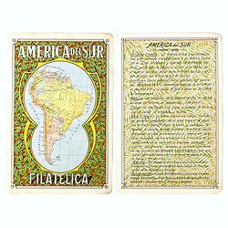
America del Sur Filatelica.

Unique manuscript map of South America. Award-winning manuscript card, prepared by Antonio Raggio for the 11th Congreso de la Union Postal Universal (World Postal Congres...

$200 / ≈ €176
Maker / Publisher: RAGGIO, Antonio F.
Place & Date: Buenos Aires, 1939


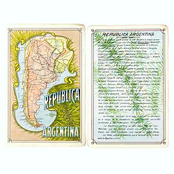
Republica Argentina.

Unique manuscript map of Argentina. Award-winning manuscript card, prepared by Antonio Raggio for the 11th Congreso de la Union Postal Universal (World Postal Congress) E...

$200 / ≈ €176
Maker / Publisher: RAGGIO, Antonio F.
Place & Date: Buenos Aires, 1939