Browse Listings
![[Religion Map].](/uploads/cache/46153-250x250.jpg)
[Religion Map].
A detailed map from Учебный Географический Атлас published by the very successful St. Petersburg publisher "Cartographic institution A.Ilin...
Date: St. Petersburg, 1899
![[Europe].](/uploads/cache/46155-250x250.jpg)
[Europe].
A detailed map from Учебный Географический Атлас published by the very successful St. Petersburg publisher "Cartographic institution A.Ilin...
Date: St. Petersburg, 1899
![[Euroidenic Columns all parts of the light].](/uploads/cache/46171-250x250.jpg)
[Euroidenic Columns all parts of the light].
A detailed map from Учебный Географический Атлас published by the very successful St. Petersburg publisher "Cartographic institution A.Ilin...
Date: St. Petersburg, 1899
![[Asia].](/uploads/cache/image-250x250.png)
[Asia].
A detailed map from Учебный Географический Атлас published by the very successful St. Petersburg publisher "Cartographic institution A.Ilin...
Date: St. Petersburg, 1899
![[Africa].](/uploads/cache/46177-250x250.jpg)
[Africa].
A detailed map from Учебный Географический Атлас published by the very successful St. Petersburg publisher "Cartographic institution A.Ilin...
Date: St. Petersburg, 1899
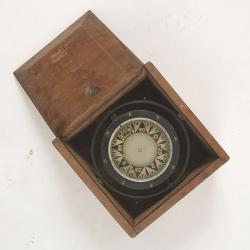
Compass.
A sloop compass in the original wooden box with lit. The compass with floating rose (Cardan system). Slung in gimbals, the east point is decorated and graduated in half ...
Date: c. 1890-1900
![Nankin [Nanjing, Jiangsu]](/uploads/cache/30031-250x250.jpg)
Nankin [Nanjing, Jiangsu]
Very detailed (1:1.000.000) map showing the area north of Nanjing, Jiangsu. The French Service géographique des armées was founded in 1887 and provided the French milit...
Date: Paris, 1900
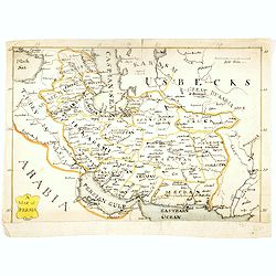
A map of Persia.
Manuscript map of Persia, including Armenia, Georgie, Caspian Sea, etc.
- $250 / ≈ €216
Date: ca. 1900
![[Oxford Canal from Oxford to Coventry].](/uploads/cache/37232-250x250.jpg)
[Oxford Canal from Oxford to Coventry].
Manuscript map covering the Oxford Canal. Orientated East to the North. The Oxford Canal is a 78-mile-long (126 km) narrow canal in central England linking Oxford with Co...
- $140 / ≈ €121
Date: ca. 1900
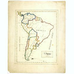
S America by Mas T.J. Sackels.
Pen and ink on card board. Map of South America drawn by T.J.Shackels. Probably a school exercise.
- $120 / ≈ €104
Date: England, ca. 1900
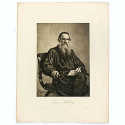
Léon Tolstoy.
Etching by Gustaf Frank after a painting of Ilya Repin (1887). Gustav Frank (1859-1923) attended school in Vlasim, where he learned to draw from Cenka Schneider. Then he ...
- $50 / ≈ €43
Date: Vienna, 1900
![[West Central London from Booth's Poverty Map of London]](/uploads/cache/40267-250x250.jpg)
[West Central London from Booth's Poverty Map of London]
A map of West Central London, one section (of twenty) of an extended version of the incredibly influential Poverty Map, originally published in Charles Booth's 'Life and ...
Date: London, 1900
![[map printed on a tissue] The British remedy for coughs and colds. Owbridge's lung tonic.](/uploads/cache/40288-250x250.jpg)
[map printed on a tissue] The British remedy for coughs and colds. Owbridge's lung tonic.
Handkerchief showing a map of Europe and part of Asia continent printed on a tissue. OWBRIDGE’S LUNG TONIC, THE BRITISH REMEDY FOR COUGHS AND COLDS.Walter Thomas Owbrid...
- $400 / ≈ €345
Date: London, ca. 1900
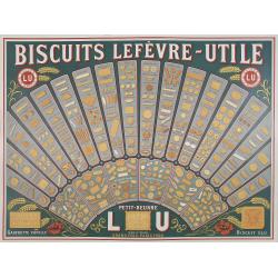
(Publicity) Biscuit Lefèvre-Utile.
Colorful advertisement of the famous French cookie brand LU.The Lefèvre-Utile Biscuit Co. Was a baker and cookie maker founded in Nantes, France in 1846 by Jean-Romain L...
- $600 / ≈ €518
Date: Joubain et Beuchet, Nantes, ca. 1900
![[Les anciennes provinces Françaises à la ville de Saint Denis].](/uploads/cache/41681-250x250.jpg)
[Les anciennes provinces Françaises à la ville de Saint Denis].
Nine small chromolithography's trade cards for Ville de Saint Denis, each with French regions and places, with description in French on each verso.Cards of the regions : ...
Date: Paris, circa 1900
![[Les anciennes provinces Françaises à la ville de Saint Denis].](/uploads/cache/41683-250x250.jpg)
[Les anciennes provinces Françaises à la ville de Saint Denis].
Nine small chromolithography trade cards for Ville de Saint-Denis, each with French regions and places, with description in French on each verso.Cards of the regions: Lor...
Date: Paris, circa 1900
![[Les anciennes provinces Françaises à la ville de Saint Denis].](/uploads/cache/41684-250x250.jpg)
[Les anciennes provinces Françaises à la ville de Saint Denis].
Nine small chromolithography's trade cards for Ville de Saint Denis, each with French regions and places, with description in French on each verso.Cards of the regions : ...
Date: Paris, circa 1900
![[Map of Grodno gubernia.]](/uploads/cache/81813-250x250.jpg)
[Map of Grodno gubernia.]
Карта Гродненско&...
- $450 / ≈ €389
Date: Sankt Peterburg, 1850-1900
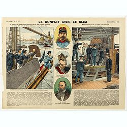
Le conflit avec le siam. (N°195)
Broad sheet relating to The Franco-Siamese War of 1893, a conflict between the French Third Republic and the Kingdom of Siam. Auguste Pavie, French vice consul in Luang P...
Date: Epinal, ca. 1900
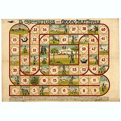
Il cacciatore - Giuoco Dilettevole.
Game of the Goose with 63 numbered boxes, rules in the lower margin. In this game, more players can play and a prismatic die is used with 14 numbers. Whoever goes to the ...
Date: Milan, ca. 1900
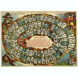
Giuoco dell' Oca. La tentazione
Uncommon Italian Game of the Goose in 90 boxes. The rules of the game are explained as follows: "REGOLA DEL GIUOCO: Questo giuoco è composto di 90 numeri e può ser...
Date: Italy, ca. 1900
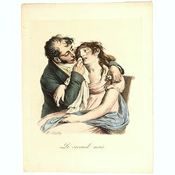
Le Second Mois. (The second month).
Lithograph depicting a woman suffering and her husband supporting her with the early pregnancy sicknesses.Belonging to the series "LES GRIMACES" by Louis-Léopo...
- $50 / ≈ €43
Date: Paris, c. 1830-1900
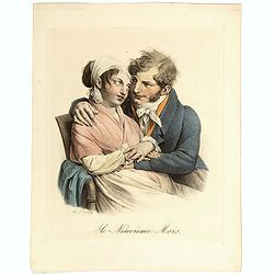
Le Neuvieme Mois.
Lithograph depicting a woman and her husband awaiting for the childbirth moment.Belonging to the series "LES GRIMACES" by Louis-Léopold Boilly (1761-1845), lit...
- $50 / ≈ €43
Date: Paris, c. 1830-1900
![Drehbare Tasschen Sternkarte Brieftasche Format . . . [Calendrier perpetuel]](/uploads/cache/44965-250x250.jpg)
Drehbare Tasschen Sternkarte Brieftasche Format . . . [Calendrier perpetuel]
Calendrier perpetual prepared and published by Otto Maier in Regensburg. This "Rotatable Cosmos Star Chart" shows in no time the currently visible sky detail. Y...
- $200 / ≈ €173
Date: Regensburg, ca. 1900
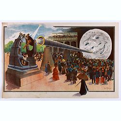
La Lune à un Mètre [Mini poster for Paris Exposition Universelle)
Original lithograph poster for the "Paris Exposition Universelle," held between April and November 1900, which attracted 50 million visitors. In 1899, director...
Date: Paris, c.1900
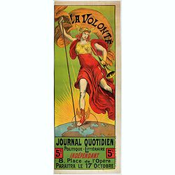
La Volonté - Journal politique et littéraire.
Advertising poster for the French newspaper La Volonté, made by Armand Point and printed by Imp. Vercasson. Showing Mercury standing on the globe showing the European pa...
- $700 / ≈ €605
Date: Paris, ca. 1900
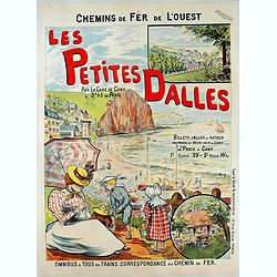
Les petites dalles.
Advertising poster for Chemins de fer de l’ouest, made by Fernel and printed by J. Van Gindertaele, Paris.Les Petites-Dalles is located in a valley on the Alabaster coa...
- $900 / ≈ €777
Date: Paris, ca. 1900
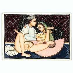
Indian painting on ivory
Fine oriental miniature of an amourouse Indian couple. Drawing, brush and gouache on ivory panel, late 19th/ early 20th cent.
Date: India, ca. 1900
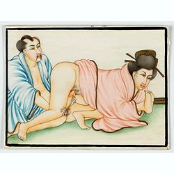
Indian painting on ivory
Fine oriental miniature of an Japanese looking couple. Drawing, brush and gouache on ivory panel, late 19th/ early 20th cent.
Date: India, ca. 1900
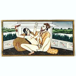
Indian painting on ivory
Fine oriental miniature of a amorous scene of an Indian couple with a landscape in the back. Drawing, brush and gouache on ivory panel, late 19th/ early 20th cent.
Date: Iran, India, ca. 1900
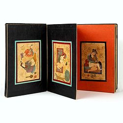
Eight Indian paintings, accordion mounted.
SUPERB SET of eight remarkable free miniatures, presenting couples in natural decorations. The miniatures are painted in Iran or India in late 19th - early 20th century]....
Date: Iran, India, ca. 1900
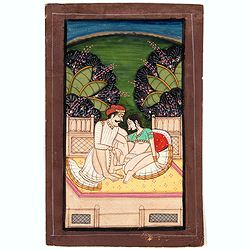
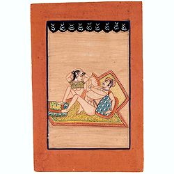
Indian painting on paper.
Fine miniature, presenting a couple in love making position, set on a balcony with in a landscape in the background. The miniature has been painted in India in late 19th ...
Date: India, ca. 1900
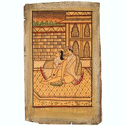
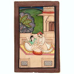
Indian painting on paper.
Fine miniature, presenting a couple in love making position, set in an interior. The miniature has been painted in India in late 19th - early 20th century. The miniature ...
Date: India, ca. 1900
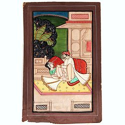
Indian erotic painting on paper.
Fine miniature, presenting a couple in a love-making position, set on a balcony within a landscape in the background. The miniature was painted in India in the late 19th ...
Date: India, ca. 1900
Indian painting on paper of a couple in a love-making position.
Fine miniature, presenting a couple in a love-making position. The miniature was painted in India in the late 19th - early 20th century. The miniature is 165 x 108 mm, pa...
Date: India, ca. 1900
Indian painting on paper of a couple in a love-making position.
Fine miniature, presenting a couple in a love-making position, set on a balcony with in a landscape in the background. The miniature was painted in India in the late 19th...
Date: India, ca. 1900
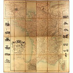
Carte routière de France de Dion Bouton spéciale pour automobiles
Highly decorative folding wall map of France in a scale of 1 : 800 000. In the upper left hand corner an inset plan of Paris, upper right Algeria and lower right map of C...
- $1500 / ≈ €1296
Date: Paris, J. Barreau, 1900
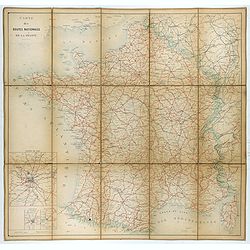
Carte nationale des routes de la France.
Map of the national roads in France, engraved and published by Regnier et Dourdet. Four inset maps of which three shows the three largest cities in France and one shows C...
- $75 / ≈ €65
Date: Paris, ca. 1900
![Le Malade Imaginaire. [Plate 48]](/uploads/cache/47424-250x250.jpg)
Le Malade Imaginaire. [Plate 48]
Illustration from the "Le Malade Imaginaire" by Félix Lorioux . This plate 48 has a caption that roughly translates as: "I hear some great news", Mr ...
Date: Paris, ca. 1900
![Le Malade Imaginaire. [Plate 61]](/uploads/cache/47425-250x250.jpg)
Le Malade Imaginaire. [Plate 61]
Humorous illustration from the "Le Malade Imaginaire" by Félix Lorioux. This Plate 61 has a caption that reads: "A doctor, having posed a question to Arga...
Date: Paris, ca. 1900
![Le Malade Imaginaire. [Plate 6]](/uploads/cache/47426-250x250.jpg)
Le Malade Imaginaire. [Plate 6]
Humorous illustration from the "Le Malade Imaginaire" by Félix Lorioux . This plate 6 has a caption that roughly translates "There was not a day when Arga...
Date: Paris, ca. 1900
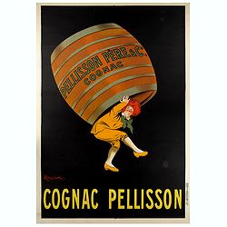
COGNAC PELISSON.
Original advertising poster for the French cognac brand Pellisson, printed by Imprimerie Vercasson, in Paris, designed by Leonetto Cappiello. Leonetto Cappiello, born in ...
Date: Paris, ca. 1900
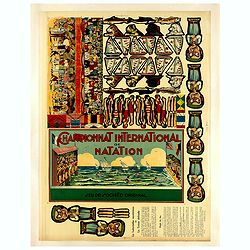
Championnat international de natation.
Uncut sheet for a game for kids " Championnat international de notation", showing images of swimmers donned in swimsuits representing their respective countri...
- $350 / ≈ €302
Date: Saussine, Paris, 1900
![[Game of the goose] Het nieuw vermakelijk ganzenspel. Le nouveau jeu d'Oie.](/uploads/cache/48331-250x250.jpg)
[Game of the goose] Het nieuw vermakelijk ganzenspel. Le nouveau jeu d'Oie.
Game of 63 boxes, spiral, counter clockwise. Goose board game with spiral with 63 numbered squares. In different boxes a representation of a goose. In a box on the center...
- $100 / ≈ €86
Date: Turnhout, ca.1900
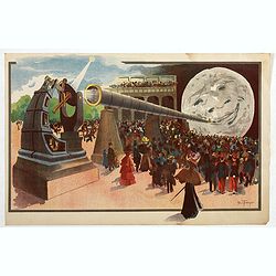
La Lune à un Mètre (Mini poster for Paris Exposition Universelle)
Original chromo-lithograph mini poster for "Paris Exposition Universelle" held between April and November, 1900, which received 50 million visitors. In 1899, ...
- $900 / ≈ €777
Date: Paris, c.1900
![[Game of the goose] Nouveau Jeu des Singes.](/uploads/cache/48327-250x250.jpg)
[Game of the goose] Nouveau Jeu des Singes.
Game of 30 boxes, spiral, counter clockwise, showing apes and in the center apes enjoying a dinner. The example was made by "Imagerie d'Epinal" and in upper rig...
- $150 / ≈ €130
Date: Epinal, ca.1900
![[Game of the goose] Het nieuw vermakelijk ganzenspel. Le nouveau jeu d'Oie.](/uploads/cache/48365-250x250.jpg)
[Game of the goose] Het nieuw vermakelijk ganzenspel. Le nouveau jeu d'Oie.
Game of 63 boxes, spiral, counter clockwise. Goose board game with spiral with 63 numbered squares. In different boxes a representation of a goose. In a box on the center...
- $100 / ≈ €86
Date: Turnhout, ca.1900
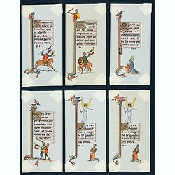
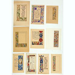
Six illuminated neo-gothic cards on vellum paper for a Book of Hours, in French.
Six very finely executed drawings on vellum paper, being a model for a neo-Gothic religious book. Text in French, with border illustrations of knight scenes, one relating...
Date: Paris, ca. 1900
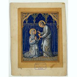
Illuminated neo-gothic card on vellum paper for a Book of Hours.
A very finely executed drawing on vellum paper, being a model for a neo-Gothic religious book.Original designs made in the atelier of the Parisian publisher of religious ...
Date: Paris, ca. 1900
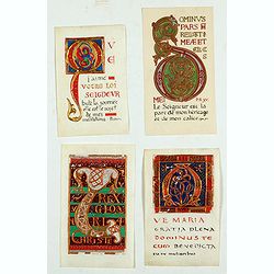
Ten Illuminated neo-gothic cards on vellum paper for a Book of Hours.
Ten very finely executed drawings on vellum paper, being models for neo gothic religious books. Text in Latin, with a decorated 2-line initial A.Made in the atelier of th...
Date: Paris, ca. 1900
Four illuminated neo-gothic cards on vellum paper for a Book of Hours, in French.
Four very finely executed drawings of border designs on vellum paper, being a model for a neo gothic religious book. Made in the atelier of the Parisian publisher of reli...
Date: Paris, ca. 1900
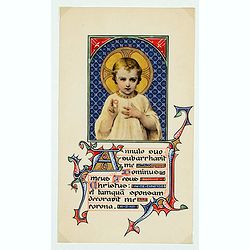
Illuminated neo-gothic card on vellum paper for a Book of Hours.
A very finely executed drawing on vellum paper, being a model for a neo gothic religious book. Text in Latin, with a decorated 2-line initial A.Made in the atelier of the...
Date: Paris, ca. 1900
![[Board game] - La course autour du Monde.](/uploads/cache/48521-250x250.jpg)
[Board game] - La course autour du Monde.
Very rare French board game - no other copies known. The game consists of 50 fields linked to the lines of longitude. A globe lies in the center of the board to symboli...
Date: Paris, ca. 1900

Anamorphose.
Perspective anamorphosis is an ingenious perspective technique that gives a distorted image of the subject represented in a picture when seen from the usual viewpoint but...
- $750 / ≈ €648
Date: Paris, ca. 1900
Anamorphose.
Perspective anamorphosis are an ingenious perspective technique that gives a distorted image of the subject represented in a picture when seen from the usual viewpoint bu...
- $750 / ≈ €648
Date: Paris, ca. 1900
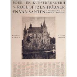
Kasteel Heeswijk.
Very fine etching of the Castle of Heeswijk, by the well-known etcher Ludwig Willem Reymert Wenckebach. He was born in The Hague on 12 January 1860 and died in 1937. The ...
Date: Amsterdam, 1901
Peking. ( Pictorial map)
This pictorial map of this Game of the Goose, published at the time of the Boxer War, shows well the situation of Pei-Ho and Tientsin in relation to Peking. There are 42 ...
- $600 / ≈ €518
Date: France, ca.1901

COLLECTION OF HONG KONG MAPS, BOOKS & FLYERS. Including CHINA - HONGKONG surveyed by Captn. Sir Edward Belcher, in H.M.S. Sulphur 1841. Corrected to 1901.
A collection of 30 maps, prints, and publications relating to Hong Kong. Including : - BELCHER, E. Sir, An updated version of this most important nautical chart of Hong K...
Date: London, 1841 - 1901
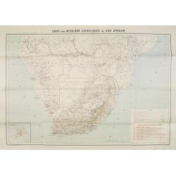
Carte des Missions Catholiques du Sud Africain.
Map of the Catholic Missions in South Africa. Inset map of L'Ile St. Hélène.Published as supplement of the Les Missions Catholiques. To the lower right an inset key to ...
Date: Paris, Monrocq, 1902
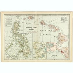
Philippine Islands and Hawaii.
Map of Philippine Islands and Hawaii, with inset maps of Manila, Honolulu, and Pearl Harbor, circa 1902, from the 10th edition of Encyclopaedia Britannica.
- $40 / ≈ €35
Date: London, ca. 1902
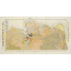
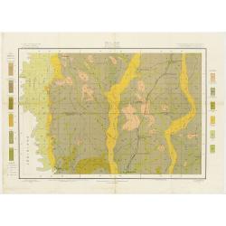
Soil map - Florida, Gadsden County sheet.
Early color lithographed soil map by Julius Bien & Co. in New York for the Department of Agriculture. Legends at the side give detail on soil type, etc. They also inc...
- $40 / ≈ €35
Date: New York, 1903
Soil map - South Carolina Campobello Sheet.
Early color lithographed soil map by Julius Bien & Co. in New York for the Department of Agriculture. Legends at the side give detail on soil type, etc. They also inc...
- $50 / ≈ €43
Date: New York, 1903
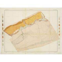
Soil map - Virginia Norfolk Sheet.
Soil map printed by Julius Bien & Co. in New York for the Department of Agriculture. The map gives great detail of the area centered on Norfolk, Potsmouth, Chesapeake...
- $50 / ≈ €43
Date: New York 1903
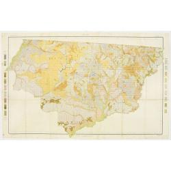
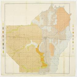
![[Soil map] Virginia-Maryland-West Virginia, Leesburg sheet.](/uploads/cache/23257-250x250.jpg)
[Soil map] Virginia-Maryland-West Virginia, Leesburg sheet.
Early color lithographed soil map by Julius Bien & Co. in New York for Department of Agriculture. Legends at side give detail on soil type, etc. They also include int...
Date: New York, 1903
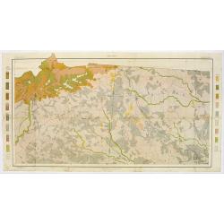
Soil map - Pennsylvania, Lockhaven sheet.
Early color lithographed soil map by Julius Bien & Co. in New York for Department of Agriculture. Legends at side give detail on soil type, etc. They also include int...
- $50 / ≈ €43
Date: New York, 1903
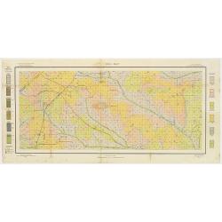
Soil map - Texas, Nacogdoches sheet.
Early color lithographed soil map by Julius Bien & Co. in New York for Department of Agriculture. Legends at side give detail on soil type, etc. They also include int...
- $75 / ≈ €65
Date: New York, 1903
Soil map - Georgia, Fort Valley sheet.
Early color lithographed soil map by Julius Bien & Co. in New York for Department of Agriculture. Legends at side give detail on soil type, etc. They also include in...
- $50 / ≈ €43
Date: New York, 1903
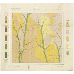
Soil map - Mississippi, McNeill sheet.
Soil map printed by Julius Bien & Co in New York for Department of Agriculture. The map is giving great detail of the area McNeill, Mississippi, in the year 1903. Soi...
- $50 / ≈ €43
Date: New York, 1903
Soil map - Louisiana, Ouachita sheet.
Early color lithographed soil map by Julius Bien & Co. in New York for Department of Agriculture. Legends at side give detail on soil type, etc. They also include int...
- $40 / ≈ €35
Date: New York, 1903
![Wusung River or Hwang Pu. / Wusung River Entrance [With Shanhhai]](/uploads/cache/48595-250x250.jpg)
Wusung River or Hwang Pu. / Wusung River Entrance [With Shanhhai]
A fine Survey chart no. 1601 showing Wusung River or Hwang Pu. / Wusung River Entrance [With Shanghai]
- $800 / ≈ €691
Date: London, 1887 - 190, updated to 1903

CANTON Kong-Teheou.
Very detailed (1:1.000.000) map centered on Macao and Victoria Island, showing soundings, English, Australian, Danish telegraph lines reaching Hong Kong and extended to M...
Date: Paris, 1898 updated for june 1904
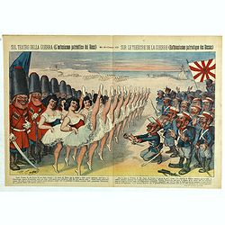
Sul teatro della guerra (L'entusiasmo patriottico dei Russi) - Rana N. 10 (Cent.10) - Sur le théâtre de la guerre (enthousiasme patriotique des Russes).
Satirical depiction of the Russo-Japanese war, which began in February 1904,we can see the opposed armies of the Russian and those of the Japanese Empire for the control ...
Date: Bologna, 11 March 1904
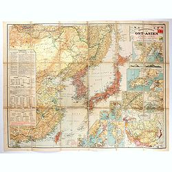
Übersichtskarte von Ost-Asien im Maßstabe 1: 5.000.000 mit 14 Beikarten in großen Maßstäben . . .
A large, uncommon map of East Asia prepared by Karl Peucker, and published by Ataria & Co. Striking and heavily annotated with information on China, Korea, Japan, and...
Date: Vienna, Artaria, 1904
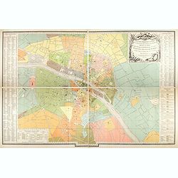
Plan des paroisses de Paris avec la distinction des parties éparses qui en dépendent dressé... par J. Junié, Ingén. Géogr. De Monseigneur l'Archeveque et géomètre des Eaux et forêts de ...
Large wall map size plan of Paris in 4 separate sheets, if joined forming a plan of Paris of 93 x 60cm. This plan is a 1904 version of a manuscript plan drawn in 1786 by ...
Date: Paris, Service des Travaux historiques de la Ville de Paris, 1904
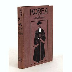
Korea. Das Land des Morgenrots. Nach seinen Reisen geschildert von Angus Hamilton. Autorisierte Übersetzung aus dem Englischen.
With 114 illustrations after photographes and one map.
- $175 / ≈ €151
Date: Leipzig: Spamer, 1904

A Humorous Diplomatic Atlas of Europe and Asia. / 滑稽欧亜外交地図 / Kokkei Ō-A Gaikō Chizu.
A wonderful example of the rare 1904 Kisaburo Ohara satirical 'Octopus Map' of Europe being swallowed by an octopus (Russia). Composed at the outbreak of the Russo-Japane...
Date: Tokyo, April, 1904
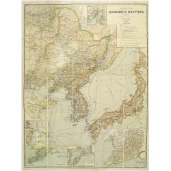
Map of the Far East
rare map including, Corea, Japan and China, prepared by Leonid Ivanovich Borodovsky, (1870-1906) and published in 1904. This folding map has several insets, one with Tai...
- $1000 / ≈ €864
Date: St. Petersburg, A.Ilyin, 1904

Excelsiori (Rana N. 28 - Cent. 20).
"After so many wars and so many troubles, young Russia, in a more serene glaze all the beautiful sun of freedom you will enjoy ... ". Fascinating allegorical sa...
Date: Bologna, 1905
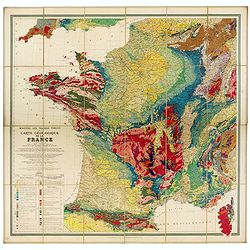
Carte géologique de la France.
Early geological map of France, published by Charles Béranger. Full title: " Ministère des Travaux publics, Carte géologique de la France 1:1'000'000, Exécutée ...
- $1200 / ≈ €1036
Date: Paris, 1905