Browse Listings

Russian Perestroika Ballet Poster.
Wonderful and delicate Russian Perestroika poster depicting a ballerina. On the frills of her skirt, there are several messages written down, which mean « a coupon for s...
Date: Russia, 1990
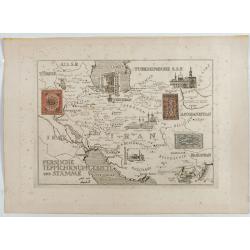
Persische Teppichknüpfgebiete und Stämme.
Map of Iran and neighboring countries in German language, published in limited edition probably in France : "Gravée à l'eau-forte et au burin. Edition limitée&quo...
Date: France ?, after 1935 - before 1991
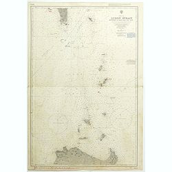
China Sea Luzon Strait between Luzon and Tai-Wan from the United States & Japanese Government chartsto 1929. . . (3804)
A highly corrected version of Admiralty chart 3804 originally published 18 September 1925 under the Superintendence of Captain P.H. Douglas. New Editions 18th December 19...
- $150 / ≈ €129
Date: London, 1929 / 1992
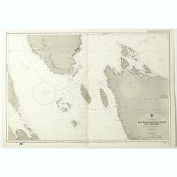
China sea Gulf of Tongking (Southern sheet).
A highly corrected version of Admiralty chart 3989 originally published 11 Mai 1962 under the Superintendence of Captain EG Irving. Detailed chart including the coasts of...
- $80 / ≈ €69
Date: London, 1962 - 1992
West Indies Virgin islands Sheet III Tortola I. to Culebra including St. Thomas...
An British Admiralty chart of the Virgin Islands. A highly corrected version of Admiralty chart 2452 originally published 15th December 1856 under the Superintendence of ...
- $135 / ≈ €116
Date: London, 1856- 1988-1993
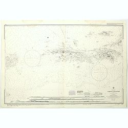
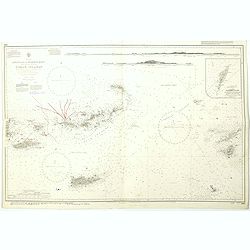
China Sea Philippine Islands - San Bernandino Strait and approaches. (3370)
A highly corrected version of Admiralty chart 3370 originally published 14th November 1924 under the Superintendence of Captain H.P. Douglas. Edition Date 1982 with furth...
- $150 / ≈ €129
Date: London, 1924 / 1996

Philippine Islands - Semirara, Ilin and Ambulong 1.s with part of Mindoro. (971)
A highly corrected version of Admiralty chart 971 originally published 15th February 1866 under the Superintendence of Captain G.H. Richards. Edition Date 1991 with furth...
- $150 / ≈ €129
Date: London, 1866 / 1999
West Indies Anguilla to Puerto Rico showing the approaches to the Virgin Islands . . .
A highly corrected version of Admiralty chart 130 originally published 22nd June 1868 under the Superintendence of Captain G.H. Richards. Edition Date 1974 with further c...
- $100 / ≈ €86
Date: London, 1868 - 1999

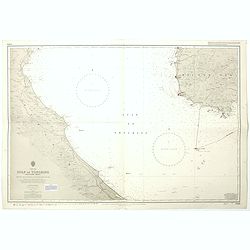
Philippine Islands - Mindanao West Coast - Basilan Strait to Camiguin Island including Tubbataha Reefs. . . (3811)
A highly corrected version of this oversized Admiralty chart 3811 originally published 26th February 1925 under the Superintendence of Captain P.H. Douglas. Edition Date ...
- $150 / ≈ €129
Date: London, 1925 / 2005

July tenth: The Flaming Tsunamis fatter than Albert a billion ernies stuck lucky and the best of the worst.
Poster by Justin Santora, numbered 8/65 ans signed in pencil, in the lower right margin.Santora began working as a freelance illustrator and screen printer like some of C...
Date: Chicago, ca. 2008
![Grote Atlas van de Verenigde Oost-Indische [Complete set of 7 volumes] Compagnie/Comprehensive Atlas of the Dutch United East India Company](/uploads/cache/49206-250x250.jpg)
Grote Atlas van de Verenigde Oost-Indische [Complete set of 7 volumes] Compagnie/Comprehensive Atlas of the Dutch United East India Company
This seven volume atlas was published in a limited edition. It covers all territories and possessions under the Charter of the Dutch East India Company (VOC) from 1602-17...
Date: Voorburg, Asia Maior/Atlas Maior, 2006-2010
![[Lot of 3] Celestial chart depicting astronomical division of the earth.](/uploads/cache/IMG_2256-250x250.jpg)
[Lot of 3] Celestial chart depicting astronomical division of the earth.
A chart depicting the astronomical division of the earth. With on both sides a descriptionary text. All within an elaborate and very decorative border. A very fine item. ...
- $250 / ≈ €215
Date: Paris, L.C. Desnos,1761.

Carte géologique détaillée. Beyrouth.
Geological or soil map showing part of Lebanon with Beyrouth, including in top a colored legend with signs of the different geological ages. Provenance : Fondation P. Fal...
Date: Liban, Service geographique des F.F.L., 1945.

Carte géologique détaillée. Jezzîne.
Geological or soil map showing part of Lebanon with Jezzîne, including a legend with signs of the different geological ages and giving many information of greatest inter...
Date: Liban, Service geographique des F.F.L., 1945.

Carte géologique détaillée. Râchaïya Nord.
Geological or soil map showing part of Lebanon with Râchaïya , including a legend with signs of the different geological ages and giving many informations of greatest i...
Date: Liban, Service geographique des F.F.L., 1945.

Carte géologique détaillée. Zahle.
Geological map showing part of Lebanon with Zahle. , including a legend with signs of the different geological ages. Provenance : Fondation P. Fallot
Date: Liban, Service geographique des F.F.L., 1945.

Carte geologique detaillee. Jbail.
Geological or soil map showing part of Lebanon with Jbail antique Byblos Ancien Port phenicien / scale 1 : 50 000., including a legend with signs of the different geologi...
Date: Liban, Service geographique des F.F.L., 1945.
![[Set of two maps of the Pacific Ocean with transportation lines, with Ottoman script]](/uploads/cache/44327-250x250.jpg)
[Set of two maps of the Pacific Ocean with transportation lines, with Ottoman script]
Two post card size maps showing the Pacific Ocean with transportation lines. The maps are in Ottoman script prepared by Mehmet EŞREF in a small atlas : عمومولاي...
Date: Istanbul, Şirket-i Mürettibiye ve Karacoğlu Matbaas&#