Browse Listings
![[Cloth Map of Europe]](/uploads/cache/47148-250x250.jpg)
[Cloth Map of Europe]
Anglo-centric cloth map of Europe produced during WWI.Serbia, the spark that lit the conflagration of World War One, isn’t even labeled on this interesting cloth map of...
Date: London, c. 1915
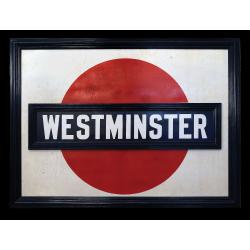
A very early large London Underground enamel station sign for Westerminster Station
This large enamel sign can be dated between 1908 and 1915, when the bull’s-eye design, a solid red disk with a horizontal bar containing the text, was adopted by all th...
- $22000 / ≈ €18697
Date: London, ca. 1908-1915
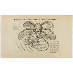
L'Impero della preda ossia la Piovra d'Absburgo.
Austro-Hungarian Octopus zinc lithographed map. A propaganda sheet attacking the Austro-Hungarian Empire, showing it as an octopus with its tentacles wrapped around the v...
Date: La Zincografia, Milan, c. 1915
![[Map of Turkey in Ottoman script]](/uploads/cache/40765-250x250.jpg)
[Map of Turkey in Ottoman script]
Map of Turkey, including Cyprus, with text in Ottoman script. In the bottom a color key to the different regions. Published by Elbemühl Graphische Industrie in Vienna (f...
Date: Vienna, ca. 1915
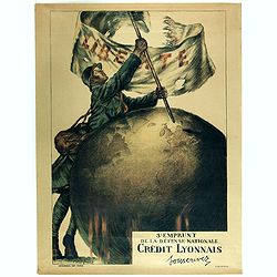
3e emprunt de la Défense nationale Crédit Lyonnais. Souscrivez.
Large color lithographed propaganda World War 1 poster. Designed by the illustrator Faivre Abel (1867-1945). A solder placing the French flag on a globe.English translati...
Date: Paris, 1917
![[Lot of Five Pacific Brand crate labels]](/uploads/cache/45706-250x250.jpg)
[Lot of Five Pacific Brand crate labels]
Five fruit crate label for Pacific Brand, showing a lemon and a map of the Pacific Ocean, centered on Hawaii and including a part of California and Asia, with also Austra...
Date: Santa Barbara, 1917
![[2 maps] Das Europa der Zukunft... / Das heutige Europa…[The Europe of the Future / The Europe of Today]](/uploads/cache/48735-250x250.jpg)
[2 maps] Das Europa der Zukunft... / Das heutige Europa…[The Europe of the Future / The Europe of Today]
A pair of very scarce WWI German maps highlighting Europe as it currently was, and Europe as it may become. The maps were produced as part of an 8 page booklet produced b...
- $2750 / ≈ €2337
Date: Paris, 1917

Mapa Polski i Krajów Osciennych - Wydanie trzecie. Opracowal Stanislaw Max. Wydani M. Arcta.
‘The Birth of Modern Poland on a map’ - an excellent wall map of Poland and surrounding regions, published in Warsaw near the end of World War I, when Poland’s fate...
Date: Warsaw, [H. Sklodowski], 1918

Guaranty Trust Company of New York. Emprunt national 6%.n Souscrivez.
Very decorative propaganda poster with design by Mark All of Paris for "Guaranty Trust Company of New York", a JPMorgan Chase predecessor in order to promote th...
Date: Paris, 1918
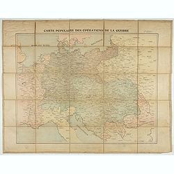
Carte populaire des opérations de la guerre. 2ème édition.
Folding map. War Operations Map showing a part of Europe, published by Epinal.
Date: Paris, ca. 1919
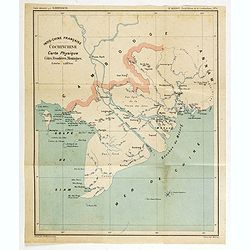
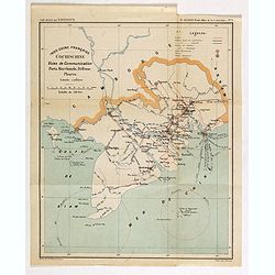
Indo-Chine Française Cochinchine. Carte Physique Côtes, Frontières, Montagnes.
Charming map of the southern third of current Vietnam whose principal city is Saigon or Prey Nokor in Khmer. It was a French colony from 1862 to 1954.Prepared by R.Brissa...
- $150 / ≈ €127
Date: Saigon, Librairie Brunet. c.1920
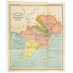
Indo-Chine Française Cochinchine. Régime des Eaux Réseaux.
Charming map of the southern third of current Vietnam whose principal city is Saigon or Prey Nokor in Khmer. It was a French colony from 1862 to 1954.Prepared by R.Brissa...
- $150 / ≈ €127
Date: Saigon, Librairie Brunet. c.1920
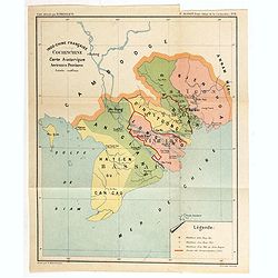
Indo-Chine Française Cochinchine. Carte historique Anciennes Provinces.
Charming map of the southern third of current Vietnam whose principal city is Saigon or Prey Nokor in Khmer. It was a French colony from 1862 to 1954.Prepared by R.Brissa...
- $150 / ≈ €127
Date: Saigon, Librairie Brunet. c.1920
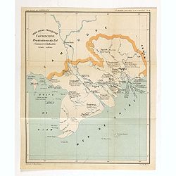
Indo-Chine Française Cochinchine. Productions du Sol Commerce, Industrie.
Charming map of the southern third of current Vietnam whose principal city is Saigon or Prey Nokor in Khmer. It was a French colony from 1862 to 1954.Prepared by R.Brissa...
- $150 / ≈ €127
Date: Saigon, Librairie Brunet. c.1920
Indo-Chine Française Cochinchine. Voies de Communication Ports Marchants, Défense Phares.
Charming map of the southern third of current Vietnam whose principal city is Saigon or Prey Nokor in Khmer. It was a French colony from 1862 to 1954.Prepared by R.Brissa...
- $150 / ≈ €127
Date: Saigon, Librairie Brunet. c.1920
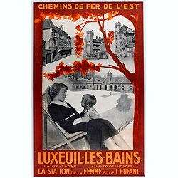
Chemin de fer de l'est - Luxeuil les Bains vers 1920.
Vintage Railway Travel Poster - Luxeuil les Bains, for the department Haute-Saône. Printed by Hachard Paris
Date: Paris, ca. 1920
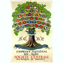
Pour que L'Arbre conserve sa vigueur, Emprunt National 6 % 1920.
Original lithograph poster printed by Devambez Paris for Société Centrale des Banques de Province and signed by L. Dappe. The poster illustrates the coats of arms of di...
- $500 / ≈ €425
Date: Paris, 1920
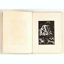
Les Strophes libertines du chevalier Naja. Bois originaux de Gécé.
First edition of this under cover published book with a collection of 20 poems celebrating "les fesses de la femme, ses lingeries et les plaisirs qu'on peut prendre ...
- $400 / ≈ €340
Date: Paris, Priape, ca. 1920
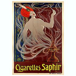
Cigarettes Saphir.
Beautiful late Art Nouveau style poster for the tobacco brand Cigarettes Saphir. Printed by Imprimerie Moullot, in Paris and designed by Stephano. The poster shows a very...
Date: Marseille, ca. 1920
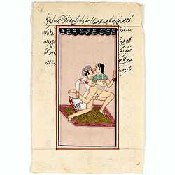
Indian painting on paper.
Fine miniature, presenting a couple in love making position, set in a landscape. The miniature has been painted in Iran or India in late 19th - early 20th century. The mi...
- $100 / ≈ €85
Date: India, ca. 1920
-250x250.jpg)
Indian painting on paper.
Fine miniature, presenting a couple in love making position. The miniature has been painted in India in early 20th century. The miniature is 165 x 110 mm, painted in oil ...
Date: India, ca. 1920
![[Title page] L'Hydrographie Françoise recueil des cartes matines dressées au dépôt des cartes, plans et journeaux.](/uploads/cache/48056-250x250.jpg)
[Title page] L'Hydrographie Françoise recueil des cartes matines dressées au dépôt des cartes, plans et journeaux.
Title page from L'Hydrographie Françoise. In the lower part of the globe, showing a part of Europe. To the left and right hand side instruments. A work of art in its ow...
- $75 / ≈ €64
Date: Paris, 1798 but ca. 1920
![[Title page] Le Neptune Francois. I Volume.](/uploads/cache/48057-250x250.jpg)
[Title page] Le Neptune Francois. I Volume.
Restrike of the title page Le Neptune Francois I. Volume" featuring Neptune in a sea-chariot drawn by white horses, fleets of ships and allegorical figures of winged...
- $100 / ≈ €85
Date: Paris, 1798 but ca. 1920
![[Title page] Le Neptune Francois. Quo ego. Sed moto praestat componere fluctus.](/uploads/cache/48058-250x250.jpg)
[Title page] Le Neptune Francois. Quo ego. Sed moto praestat componere fluctus.
Restrike of the title page featuring Neptune in a sea-chariot drawn by white horses, fleets of ships and allegorical figures of winged gods, all within an ornate border. ...
Date: Paris, 1798 but ca. 1920
![[6 Post cards of young woman seated on a globe ]](/uploads/cache/41502-250x250.jpg)
[6 Post cards of young woman seated on a globe ]
Complete set of 6 pictorial post cards showing young women seated on a globe. Signed "Morin". Unsent.More aboutcartographical curiosities [+]
Date: Italy, ca. 1920
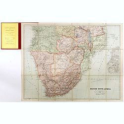
British South Africa.
With the signature of Alan Sillitoe (1928-2010), who was England’s best writer of proletarian fiction. From an early age, geography and maps were a very important part ...
- $450 / ≈ €382
Date: London, 1923
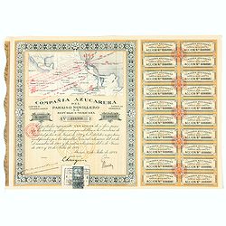
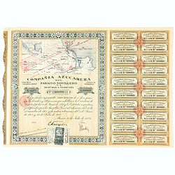
Accion de 10 pesos. No. 110,930 (Share certificate)
Beautifully engraved certificate from the "Compania Azucarera de Paraiso Novillero S.A. Republica Mexicana", share certificate No.110,930 for one share, in a $ ...
Date: Paris, 1924
Accion de 10 pesos. No. 110,931 (Share certificate)
Beautifully engraved certificate from the "Compania Azucarera de Paraiso Novillero S.A. Republica Mexicana", share certificate No.110,931 for one share, in a $ ...
Date: Paris, 1924
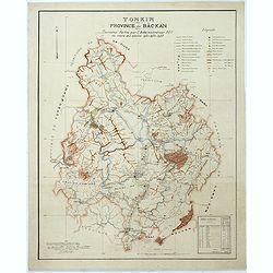
Tonkin Province de Bac-Kan Tournées faites par l'administrateur Blu au cours des années 1921-1922-1923.
Large scale manuscript map (1:200,000) centered on B?c K?n province in the northern region of Vietnam, north of the capital Hanoi.With a key in upper right corner, to the...
- $3000 / ≈ €2550
Date: Hanoï, 1924
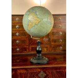
A globe by Thomas
Large terrestrial globe by G. Thomas of Paris c.1920. 12" diameter globe with printed paper surface and brass fitting. On an ebonized column basis.Thomas shows us th...
Date: Paris, ca. 1922-1924
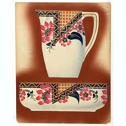
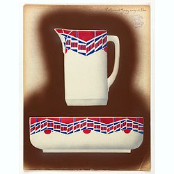
Designs for Porcelains with Chinese design.
In right hand side "Planche d'aquarelle N° 04509". and the numbers 11.103, 11.141, 11.142, 11,077, 11,101, 10,981. Original design created by the Sevres artist...
Date: Desvres, 1905 - 1925

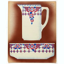
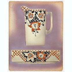
Designs for porcelain plate with Chinese design.
In right hand side "Planche d'aquarelle N° 06502". And the numbers 11.153, 11.154, 11.155. Original design created by the Sevres artist Gabriel Fourmaintraux (...
Date: Desvres, 1905 - 1925

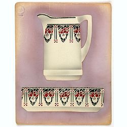
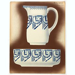
Designs for Porcelain ware with Chinese design.
In left hand side "Planche d'aquarelle N° 05501". Original design created by the Sevres artist Gabriel Fourmaintraux ( 1886 - ) at about 1910 to serve as guide...
Date: Desvres, 1905 - 1925

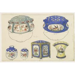
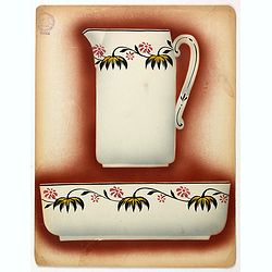
Designs for two porcelain bowls with Chinese design.
With numbers 4.601, 4.818. In top "Planche N° d'ordre : 03004.Original design created by the Sevres artist Gabriel Fourmaintraux ( 1886 - ) at about 1910 to serve a...
Date: Desvres, 1905 - 1925

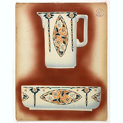
Designs for porcelain vase with Chinese motif.
With attractive pattern of a classic Chinese motif. In top "Planche d'aquarelle N° 04510" and the numbers 2,198. Original design created by the Sevres artist G...
Date: Desvres, 1905 - 1925

Designs for porcelain vases with Chinese motif.
Hand colored design of 13 vases with attractive patterns of a classic Chinese motif. In right "Planche d'aquarelle N° 04004" and the numbers 7.404, 2.074, 8.93...
Date: Desvres, 1905 - 1925
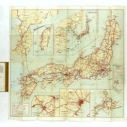
Travellers' Map of Japan, Chosen (Korea), Taiwan (Formosa) with Brief Descriptions of the Principal Tourist Points of Japan.
An early 20th century map which wss published in Tokyo for English speaking tourists.Very detailed set of maps of Japan and parts of Korea, Taiwan and part of China, show...
Date: Tokyo, 1925
![Hoo Daihiko Kinen Hiko Sugoroku [ [訪欧大飛行記念飛行双六 ]](/uploads/cache/46569-250x250.jpg)
Hoo Daihiko Kinen Hiko Sugoroku [ [訪欧大飛行記念飛行双六 ]
FIRST EDITION. A rare paper board game celebrating a flight from Tokyo to Rome Europe. Published in by Osaka Asahi Shinbun.This color offset-printed sugoroku (a paper “...
- $600 / ≈ €510
Date: Osaka, Taisho 14 or 1925
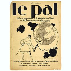
Le Pal - Nous ne connaissons ni la discipline des partis ni les complaisances de la camaraderie.
Original cover design in pen and ink by Henri Desbarbieux for the satirical bi-monthly journal Le Pal.Not much information is found about Henri Desbarbieux. In this BNF l...
Date: Paris, 1925
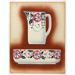
Design / Promotion card in original pochoir technique.
The ceramics of Saint-Amand-les-Eaux is a porcelain produced from 1705 in several factories in France in the Nord department and the Nord-Pas-de-Calais region . Many fact...
- $75 / ≈ €64
Date: France, ca. 1925
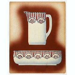
Design / Promotion card in original pochoir technique.
The ceramics of Saint-Amand-les-Eaux is a porcelain produced from 1705 in several factories in France in the Nord department and the Nord-Pas-de-Calais region . Many fact...
- $75 / ≈ €64
Date: France, ca. 1925
Design / Promotion card in original pochoir technique.
The ceramics of Saint-Amand-les-Eaux is a porcelain produced from 1705 in several factories in France in the Nord department and the Nord-Pas-de-Calais region . Many fact...
- $75 / ≈ €64
Date: France, ca. 1925
Design / Promotion card in original pochoir technique.
The ceramics of Saint-Amand-les-Eaux is a porcelain produced from 1705 in several factories in France in the Nord department and the Nord-Pas-de-Calais region . Many fact...
- $75 / ≈ €64
Date: France, ca. 1925
Design / Promotion card in original pochoir technique.
The ceramics of Saint-Amand-les-Eaux is a porcelain produced from 1705 in several factories in France in the Nord department and the Nord-Pas-de-Calais region . Many fact...
- $75 / ≈ €64
Date: France, ca. 1925
Design / Promotion card in original pochoir technique.
The ceramics of Saint-Amand-les-Eaux is a porcelain produced from 1705 in several factories in France in the Nord department and the Nord-Pas-de-Calais region . Many fact...
- $75 / ≈ €64
Date: France, ca. 1925
Design / Promotion card in original pochoir technique.
The ceramics of Saint-Amand-les-Eaux is a porcelain produced from 1705 in several factories in France in the Nord department and the Nord-Pas-de-Calais region . Many fact...
- $75 / ≈ €64
Date: France, ca. 1925
Design / Promotion card in original pochoir technique.
The ceramics of Saint-Amand-les-Eaux is porcelain produced from 1705 in several factories in France in the Nord department and the Nord-Pas-de-Calais region . Many factor...
- $75 / ≈ €64
Date: France, ca. 1925
Design / Promotion card in original pochoir technique.
The ceramics of Saint-Amand-les-Eaux is porcelain produced from 1705 in several factories in France in the Nord department and the Nord-Pas-de-Calais region . Many factor...
- $75 / ≈ €64
Date: France, ca. 1925
Design / Promotion card in original pochoir technique.
The ceramics of Saint-Amand-les-Eaux is a porcelain produced from 1705 in several factories in France in the Nord department and the Nord-Pas-de-Calais region . Many fact...
- $75 / ≈ €64
Date: France, ca. 1925
![[Map of the Monterey Peninsula.]](/uploads/cache/48349-250x250.jpg)
[Map of the Monterey Peninsula.]
A lovely example of Jo Mora's Del Monte Properties Company' California's Fun' playground tourist map of the Monterey Peninsular, published in San Francisco in 1927. The r...
- $900 / ≈ €765
Date: San Francisco, 1927

The Wonderground Map of London.
A large and pictorially striking 'Wonderland' advertising poster on behalf of the London Underground, published in the late 1920s. The poster was very popular, and ran fo...
- $4000 / ≈ €3400
Date: London, ca 1927
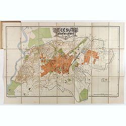
Cesu un apkartnes vadonis ar Cesu pilsetas planu. . .
Uncommon and detailed plan of Cesis and its direct surroundings. Cesis is a town in northeastern Latvia, built in the 13th century and one of the best-preserved medieval ...
- $550 / ≈ €467
Date: Cesu, 1928
Dessins de Mariette Lydis pour illustrer les Fleurs du Mal. (PL II. L'Albatros)
"L'Albatros" - Etching enhanced with watercolors and signed in pencil by Mariette Lydis, to illustrate Baudelaire's poems of "Les Fleurs du Mal".Govo...
Date: Paris, G.Govane, 1928
Dessins de Mariette Lydis pour illustrer les Fleurs du Mal. (PL XI. Le Léthé)
"Le Léthé" - Lithography enhanced with watercolors and signed in pencil by Mariette Lydis, to illustrate Baudelaire's poems of "Les Fleurs du Mal".M...
- $45 / ≈ €38
Date: Paris, G.Govane, 1928
![Tutte le strade conducono a Roma. [All roads lead to Rome]](/uploads/cache/44998-250x250.jpg)
Tutte le strade conducono a Roma. [All roads lead to Rome]
Game board of the game "All roads lead to Rome" from the Fascist era, offered by the chocolate or cocoa company Talmone-Unica. Showing a world map surrounded by...
- $1500 / ≈ €1275
Date: Turin, 1928
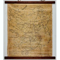
Railway map of China.
Railway map of China. Key in the left with keys to capital cities, Ocean cables, etc. Published by The Chinese Government Bureau of Economic Information, which was a nonp...
- $350 / ≈ €297
Date: China, ca. 1928
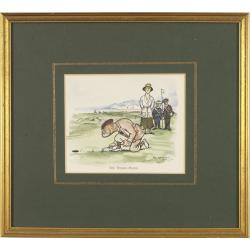
Mr. Punch on the Links.
Golfing cartoon taken from the famed English humor magazine Mr. Punch on the Links. Size of the frame : 23x25cm.THE WOMAN-HATER.After Frank Reynolds (1876 - 1953 ). He wa...
Date: London, Methuen: 1929
Ocean Pacifique Partie Ouest.
Large French sea chart featuring the western part of the Pacific Ocean with Australia, New Zealand, New Guinea, Philippines, till Korea and Japan, corrected in 1929.On th...
- $450 / ≈ €382
Date: France, 1909-1929
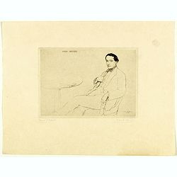
Jules Romains.
Full portrait of Jules Romains, who was born Louis Henri Jean Farigoule, a French poet and writer and the founder of the Unanimism literary movement. Dry-point by Paul-É...
Date: Paris, 1929
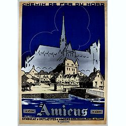
Amiens. Chemin de fer du nord.
Promoting poster for Chemin fer du Nord and Syndicat d'iniatives d'Amies. Created by Ringard & Normand, Amiens.
- $400 / ≈ €340
Date: Amiens, 1929
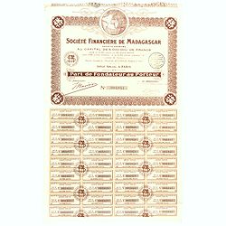
Share of 100 Francs. No. 003841 (Share certificate)
Beautifully engraved certificate from the "Société Financière de Madagascar", share certificate No. 003841 for one hundred shares, in a 5,000000 francs loan....
Date: Paris, 1929
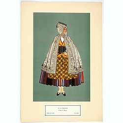
Femme de Barèges (106, La Gascogne).
Plate published in "Les costumes régionaux de France" with illustrations by Gratiane de Gardilanne (painter and designer) and Elisabeth Whitney Moffat.Costume ...
- $75 / ≈ €64
Date: Paris, Editions du Pégase, 1929
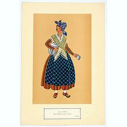
Laitière Bordelaise, d'après de Gallard (110, La Guyenne).
Plate published in "Les costumes régionaux de France" with illustrations by Gratiane de Gardilanne (painter and designer) and Elisabeth Whitney Moffat.Costume ...
- $75 / ≈ €64
Date: Paris, Editions du Pégase, 1929

The Rubaiyat of Omar Khayyam (Edward Fitzgerald translation)
Edward FitzGerald, an outstanding writer who has done more than anyone to popularise English poetry. His best-known work, The Rubaiyat of Omar Khayyam (1859), began by be...
Date: England, ca. 1930
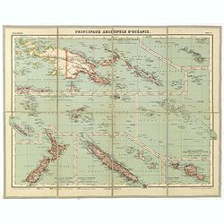
Principaux archipels d'Oceanie.
Detailed folding map of seven principal island groups in the South Pacific represented at various scales. The number and title are also on the outside front of the sheet....
- $120 / ≈ €102
Date: Paris, ca. 1930
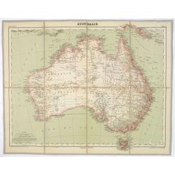
AUSTRALIE
Detailed folding maps of Australia. In upper left corner "Atlas Universal" and in upper right corner "Carte 78".In lower left "Dessiné: le trait...
Date: Paris, ca. 1930

World Flight Routes (all in Japanese).
A large very decorative Japanese world map published as sugoroku (a Japanese game which might be compared to backgammon) published as a supplement to the 1930 New Year’...
Date: Osaka, 1930
Group of 51 art déco gouaches.
Group of outstanding "art deco" gouaches (unsigned) from the workshop of "R. Pichon. Ateliers de Dessin et Lithographie – 10, rue Rochechouart – Paris&...
Date: Paris, 1920-1930

Hongarije.
Poster made for Hungarian Tourist association. The uncommon Dutch version of this fine poster to promote Hungary in the 1930's. Arisztid Uher was a graphic designer. He d...
Date: Budapest, KLOSZ / Sohn., ca. 1930
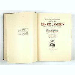
Cidade do Rio de Janeiro - Remodelação, Extensão e Embelezamento.
Important architectural book prepared by Antonio Prado Junior (1880-1955) under the general direction of Alfredo Agache ( 1875-1959) published by Foyer Brésilien editor,...
- $1100 / ≈ €935
Date: Foyer Brésilien editor, Paris, 1930

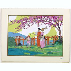
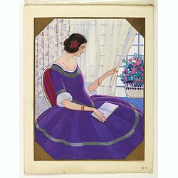
(Art déco gouache)
Outstanding "art deco" gouache (unsigned) from the workshop of "Robert Pichon. Ateliers de Dessin et Lithographie – 10, rue Rochechouart – Paris. The g...
Date: Paris, ca. 1930
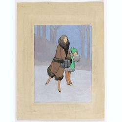
(Art-déco gouache)
Outstanding "art deco" gouache (unsigned) from the workshop of "Robert Pichon. Ateliers de Dessin et Lithographie – 10, rue Rochechouart – Paris. The g...
Date: Paris, ca. 1930
(Art-déco gouache)
Outstanding "art deco" gouache (unsigned) from the workshop of "Robert Pichon. Ateliers de Dessin et Lithographie – 10, rue Rochechouart – Paris. The g...
- $550 / ≈ €467
Date: Paris, ca. 1930

(Art-déco gouache)
Outstanding "art deco" gouache (unsigned) from the workshop of "Robert Pichon. Ateliers de Dessin et Lithographie – 10, rue Rochechouart – Paris. The g...
Date: Paris, ca. 1930
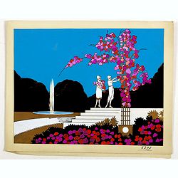
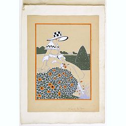
Art deco gouache of two skating persons.
Outstanding "art deco" gouache (unsigned) from the workshop of "Robert Pichon. The gouache depict a skating scene of an elegant woman with a little girl. c...
Date: Paris, ca. 1930
(Art déco gouache)
Outstanding "art deco" gouache (unsigned) from the workshop of "Robert Pichon. Ateliers de Dessin et Lithographie – 10, rue Rochechouart – Paris. The g...
Date: Paris, ca. 1930

(Art déco gouache)
Outstanding "art deco" gouache (unsigned) from the workshop of "Robert Pichon. Ateliers de Dessin et Lithographie – 10, rue Rochechouart – Paris. The g...
Date: Paris, ca. 1930
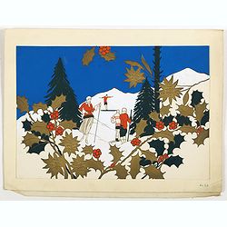
Art déco
Outstanding "art deco" gouache (unsigned) from the workshop of "Robert Pichon. The gouache depict a scene of four people skiing and holly in the first plan...
Date: Paris, ca. 1930
(Art-déco gouache)
Outstanding "art deco" gouache (unsigned) from the workshop of "Robert Pichon. Ateliers de Dessin et Lithographie – 10, rue Rochechouart – Paris. The g...
Date: Paris, ca. 1930
(Art-déco gouache)
Outstanding "art deco" gouache (unsigned) from the workshop of "Robert Pichon. Ateliers de Dessin et Lithographie – 10, rue Rochechouart – Paris. The g...
Date: Paris, ca. 1930