Browse Listings
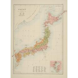
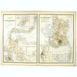
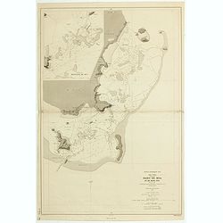
Japan.
A detailed lithographed map of Japan including Hokkaido and including a small inset of the environs of Tokyo & Yokohama. Lower part map a numbered key to divisions an...
- $200 / ≈ €170
Date: Edinburg, 1884
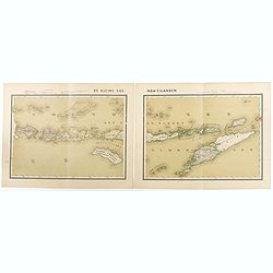
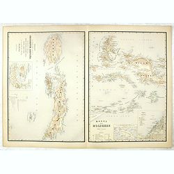
De kleine Soenda-Eilanden. Schaal van 1:800000.
Very detailed two sheet map of Soenda Islands, taken from "Atlas van Nederlandsch Oost- en West-Indie", prepared by doctor I. Dornseiffen, and published by publ...
- $30 / ≈ €25
Date: Amsterdam, Seyffardt, 1884

Driving chart of Hartford and vicinity : 15 miles around.
Road map by Albert A. Hyde & Co. of Hartford and vicinity, with the Connecticut River in the center. Published by Albert A. Hyde & Co., in New York and lithograph...
Date: New York / Philadelphia, 1884
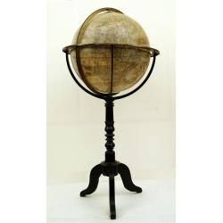
Globe terrestre d'après les découvertes..
Attractive and large (height 112cm) library globe by a prominent Paris globe maker, with a brass meridian circle, horizon ring, and hour ring, supported by four brass qua...
Date: Paris, ca. 1885
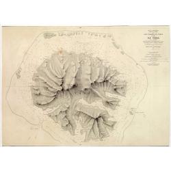
Océan Pacifique. Archipel de la Société. Iles Raiatea et Tahaa. 1ère Feuille. Ile Tahaa..
Large scale chart focused on the island Tahaa, in French Polynesia.Showing a few details of the village of Tahaa, banks, isles and soundings made in meters. Relief is sho...
- $200 / ≈ €170
Date: Paris, 1885

Wandkarte von Europa von H.Berghaus. . .
Large wall map of Europe printed in chromo-lithography. Prepared by Heinrich Berghaus and published by Justus Perthes in Gotha.Heinrich Berghaus, with support of Alexande...
Date: Gotha, Perthes, ca.1885
Kaart van Celebes / Kaart van Zuid-West-Celebes : bevattende de Gouvernem.ts, de leenroerige en een gedeelte der bondgenootschappelijke landen behoorende tot het Gouvernement van Celebes en onderh.
Very detailed map taken from "Atlas der Nederlandsche bezittingen in Oost-Indië", who was published by Departement van Koloniën".First edition of one of ...
- $50 / ≈ €42
Date: The Hague, 1883-1885
Kaart van't noordwestelijke gedeelte der Residentie Amboina . . . / Kaart der Molukken.
Two very detailed maps on one sheet, taken from "Atlas der Nederlandsche bezittingen in Oost-Indië", who was published by Departement van Koloniën".The m...
- $75 / ≈ €64
Date: The Hague, 1883-1885
![[Title page] Der Nederlandsche Bezittingen in Oost-Indië . . .](/uploads/cache/37336-250x250.jpg)
[Title page] Der Nederlandsche Bezittingen in Oost-Indië . . .
Decorative title page with, in the lower part, a schematic map of Indonesia, and two hemispheres. Taken from "Atlas der Nederlandsche bezittingen in Oost-Indië"...
- $75 / ≈ €64
Date: The Hague, 1883-1885

Kaart van Het Noordelijk Gedeelte Van Het Eiland Borneo.
A very detailed map of Northern Borneo including Brunei, taken from the "Atlas der Nederlandsche bezittingen in Oost-Indië", which was published by Departement...
Date: The Hague, 1883-1885
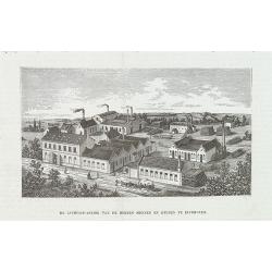
De luciferfabriek van de Heeren Mennen en Krunen te Eindhoven.
Wood engraving published in "Katholieke Illustratie", showing the match factories of Mennnen en Krunen in Eindhoven. Founded in 1870 by banker Christiaan Mennen...
- $40 / ≈ €34
Date: s-Hertogenbosch, H.Bogaerts, ca. 1885
Atlas des Missions Catholiques.
Vingt cartes teintées, avec texte explicatif par R. P. O. Werner de la Compagnie de Jésus. Traduit de l’Allemand, revu et augmenté par M. Valérien Groffier, auteur ...
- $1000 / ≈ €850
Date: Lyon, 1886
ILE UVEA CROQUIS DES BAIES DE MUA ET DE MATA UTU.
Mata-Utu is the capital of Wallis and Futuna, an overseas collectivity of France. It is located on the island of Uvéa, in the district of Hahake, of which it is also the...
- $80 / ≈ €68
Date: Paris, 1887
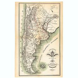
Carte générale de la République Argentine dressée d'après les données les plus récentes.
An UpToDate map of the Argentinian Republic published in Basel by "le Bureau Officiel d'Information de la République Argentine". Detailed map of Argentina show...
- $350 / ≈ €297
Date: Basel, 1887
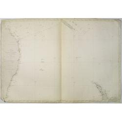
Carte de la Mer comprise entre l'Australie, la Nelle. Zélande et la Nelle.
Sea chart of the Pacific Ocean between Australia, New Zealand and New Caledonia. Including the towns of Sydney, Brisbane. The northern tip of New Zealand in lower right c...
- $350 / ≈ €297
Date: Paris, 1872 updated for 1888
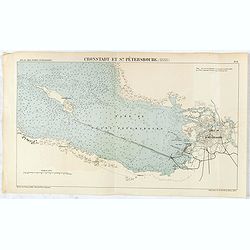
Cronstadt et St. Petersbourg.
Detailed plan of the port and city of St. Petersburg including Kotlin Island and the fortified town of Kronstadt.
- $35 / ≈ €30
Date: Paris, 1888
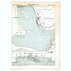
Tjilatjap (1888)
Detailed plan of the port and city of Tjilatjap on Java. Taken from "Atlas des Ports Etrangers". Lithographed by A. Simon.
Date: Paris, 1888
(Complete map of ancient and modern geography of China)
The second earliest edition of China’s first commercial map, Gujin di yu quan tu 《古今地輿全圖》(Complete map of ancient and modern geography of China) made du...
Date: Jingdu dashuntang, 1888
Etats Unis (Etats de l' Ouest).
Large format highly detailed map of the states and territories of the West, with Central America, included in a large inset titled "Etats de l'Amerique Centrale"...
Date: Paris, 1889
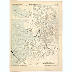
St. Pétersbourg (1888).
Map of St. Petersburg from a French multi volume atlas published by the Ministere des Travaux Publics (Ministry of Civil Engineering), called "Atlas des ports étran...
- $120 / ≈ €102
Date: ?Paris, Imprimerie Nationale 1884-1889

Paris fashion plate. (3910)
Uncommon Paris fashion plate from Le Guide des Couturières et la France elégante Réunis, under direction of Abel Goubaud.In the later quarter of the 19th century, ther...
- $30 / ≈ €25
Date: Paris, 1890
![Parthie aus dem Binnensee [Japan]](/uploads/cache/01312-250x250.jpg)
Parthie aus dem Binnensee [Japan]
Anonymous drawing made by a German during his visit to Japan. The drawing shows a lake with two Japanese vessels and a building with a Japanese flag in an mountainous lan...
- $150 / ≈ €127
Date: Japan, c. 1890
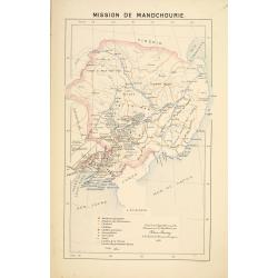
Mission de Mandchourie.
Important missionary map showing Manchuria in Russia and China, prepared by Adrien Launay, who was a French Missionary and later chronicler of the history of the French M...
- $100 / ≈ €85
Date: Lille, 1890

Russia & Poland.
Charming, folding map of Russia and Poland, giving a detailed overview of Europe from Baltic to Caspian Sea. Railways and rivers prominently delineated.In lower left a ke...
Date: London, ca. 1890
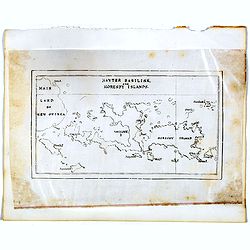
Hayter Basilisk, and Moresby Islands. (manuscript map)
An unusual small, and basic manuscript map of the Hayter Basilisk and Moresby Islands near Papua New Guinea, off the northern coast of Australia.
- $100 / ≈ €85
Date: London, ca. 1890
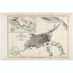
New Guinea. Map illustrating Sir. w. Macgregor's route to the Owen Stanley Range 1889.
Map illustrating Sir. w. Macgregor's route to the Owen Stanley Range 1889. With inset map of South-East New Guinea.Fine colored lithograph map lithographed by Turner &...
- $50 / ≈ €42
Date: London, Edward Stanford, 1890
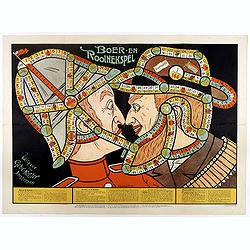
Boer-en Rooinekspel.
Design by E.G.Schlette. This is a board game similar to the famous "snakes and lessons". The game takes the players through various historical battles. Success ...
- $600 / ≈ €510
Date: Amsterdam, Koster, ca. 1890
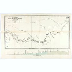
The Karun River and branches.
Karun River and branches map compiled from the charts of Colonel Chesney, Lieut. Selby and Captain Clements.The Karun continues toward the Persian Gulf, forking into two ...
Date: London, 1890
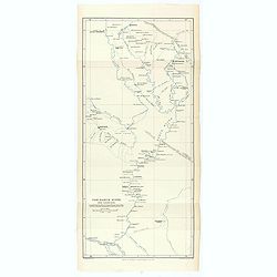
Across Luristan to Ispahan.
Map showing the route from Shushter to Ispahan by Henry Blosse Lynch. When Lynch was based in Baghdad he was in charge of the postal service across Syria between Baghdad ...
Date: London, 1890
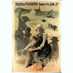
Palais du Trocadéro Samedi 14 juin à 2h.
This Palais du Trocadéro poster by Jules Charet was issued in two versions. This example is without the full lettering which would later appear at the bottom: “FETE DE...
- $650 / ≈ €552
Date: Paris, 1890

Atlas des Missions de la Société des Missions-Étrangères. . .
This scarce atlas contains maps showing the locations of the Catholic missions belonging to the Société des Missions Étrangères in Asia. It covers India, Burma, Siam,...
Date: Lille, 1890
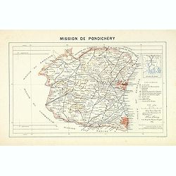
Mission du Kouang-Ton.
Important map of Pondichery in India, prepared by Adrien Launay, who was a French Missionary and later chronicler of the history of the French Missions in Indo-China at e...
Date: Lille, 1890
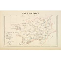
Mission du Kouang-Si.
Important missionary map showing part of China, prepared by Adrien Launay, who was a French Missionary and later chronicler of the history of the French Missions in Indo-...
Date: Lille, 1890
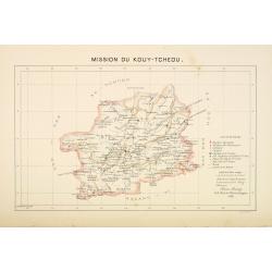
Mission du Kouy-Tcheou.
Important missionary map showing part of China, prepared by Adrien Launay, who was a French Missionary and later chronicler of the history of the French Missions in Indo-...
Date: Lille, 1890
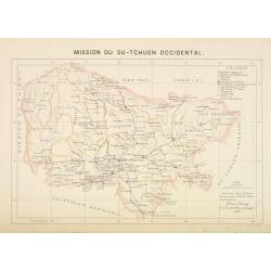
Mission du Sin-Tchuen occidental.
Important missionary map showing part of China, prepared by Adrien Launay, who was a French Missionary and later chronicler of the history of the French Missions in Indo-...
Date: Lille, 1890
![[Voyage en Suisse / Reise die Schweiz.]](/uploads/cache/48396-250x250.jpg)
[Voyage en Suisse / Reise die Schweiz.]
A first edition children's folding board game of Switzerland and its many places and sights to visit. Although it is missing most of its original components (dice, cards,...
Date: Switzerland, 1891
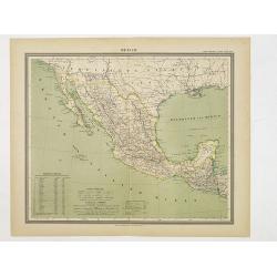
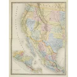
Mexico.
Decorative territorial map showing the Southwest of the United States with Mexico, Baja California and the neighboring states Arizona, New Mexico and Texas. The map exten...
Date: Glogau, 1892
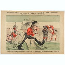
Politica Maramea Inglese - Rugantino - n°419 - Roma 17 Gennaio 1892.
Satirical print relating to the British Conquest of Egypt (1882), also known as Anglo–Egyptian War, between Egyptian and Sudanese forces under Ahmed ‘Urabi and the Un...
Date: Rome, January 17, 1892
![[Views of Korea, Thailand, Cambodia and its inhabitants and princes. Including one or more phographes by Hippolyte Frandin.]](/uploads/cache/48426-250x250.jpg)
[Views of Korea, Thailand, Cambodia and its inhabitants and princes. Including one or more phographes by Hippolyte Frandin.]
A collection of 95 photographs, of which about 60 photos feature Korea or its people, printed on albumen paper. Captions in French. The others from Thailand, China, India...
- $25000 / ≈ €21247
Date: C. 1892
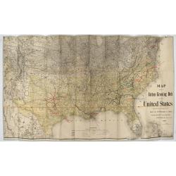
Map showing the cotton growing belt in the United States Prepared for and copyrighted by Geo. H.Mc.Fadden & Bro., cotton merchands based in Phiiladelphia, USA 1892.
The cotton-growing Belts in the Southern States for 1892 A rare map showing the cotton-growing Belts in the Southern States for 1892. Prepared for and copyrighted by G...
Date: Philadelphia, 1892
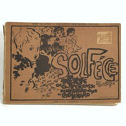
Petit solfège illustré. Illustrations de Pierre Bonnard. Deuxième mille.
30 compositions by Bonnard, mostly printed in colors, integrated with and surrounding the texts and musical passages. Publisher’s dec. boards, with full-cover illustrat...
Date: Paris, 1893

Map of Russia and Poland.
Charming, folding map of Russia, Poland and Baltic States, still in its original publisher's blind stamped linen wrapper with yellow label. With yellow advertisements at ...
Date: London, ca. 1894

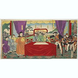
Chosen Danpan - Korean negotiation.
A scene of a Japanese legation under the command of Hanabusa Yoshitada who is forcing the Korean King Kojong (1852-1919) to agree to Japanese demands during the Chemulpo ...
Date: August 8, MEIJI 27th year or 1894

KOUSHI NYUJO no Zu - HANABUSA Legation enters in Palace, Seoul.
A scene of Japanese legation HANABUSA who are entering the Royal Palace, Seoul.
Date: August 8, MEIJI 27th year or 1894
Chosen Danpan (Discussing the clauses of the ultimatum between the Japanese, Chinese and Korean forces).
Japanese woodcut showing the Japanese, Chinese and Koreans discussing the clauses of the ultimatum between Japan, China and Korea, . Yôsai Nobukazu (1872-1944).A scene...
- $1200 / ≈ €1020
Date: August 8, MEIJI 27th year or 1894
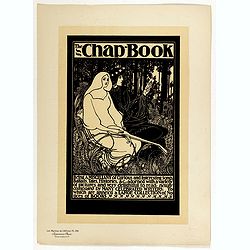
The Chap Book.
Chromo lithographed poster, "The Chap Book.", by BRADLEY, W. Plate 136, published in Maître 17, on April 1895. The "Les Maîtres de l'Affiche" contai...
Date: Paris, Imprimerie Chaix, April 1895
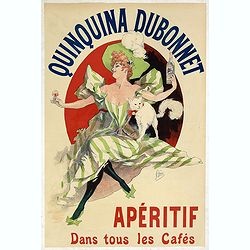
Quinquina Dubonnet, apéritif dans tous les cafés.
Original chromo lithographed medium size poster, "Quinquina Dubonnet, apéritif dans tous les cafés", by CHERET, signed in the plate. Supplement to "Courr...
Date: Paris, Imprimerie Chaix, 1895
![[Title in Ottoman Turkish: SOUTHERN AFRICA].](/uploads/cache/44732-250x250.jpg)
[Title in Ottoman Turkish: SOUTHERN AFRICA].
A fine Ottoman map of Southern Africa from Ali Şeref Paşa’s rare "Yeñi coġrafya aṭlası", published by the press of Matbaa-i Amire, the successor of İb...
- $350 / ≈ €297
Date: Beyazit, Istanbul: Matbaa-i Amire 1311 or 1895
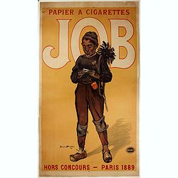
Papier a cigarette JOB
Large publicity poster for the cigarette paper by the poster artist Firmin Bouisset (1859-1925).
- $900 / ≈ €765
Date: Paris, Affiches Camis, 1895
![Joan of Arc [...] April Harper's.](/uploads/cache/46522-250x250.jpg)
Joan of Arc [...] April Harper's.
Poster for the magazine Harper's. It was used to be a gift of the American Friends of the V&A.The poster is depicting Joan of Arc holding a flag in one hand and point...
- $750 / ≈ €637
Date: Paris, 1895
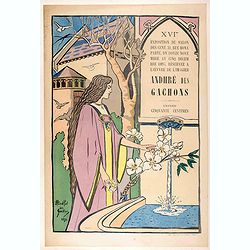
Exposition Salon des Cent, 31, rue Bonaparte, du douze novembre au cinq décembre1895, réservée à l'œuvre de l'imagier Andhré des Gachons.
Chromolithograph advertising poster for Harper's magazine. The poster shows a woman near a fountain.Signed in the plate on the lower left corner. Published by A. Davy, in...
- $1500 / ≈ €1275
Date: Paris, 1895
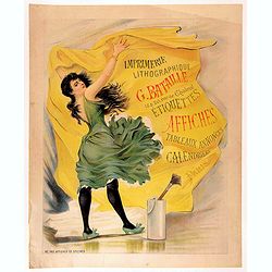
Imprimerie lithographique G. BATAILLE 18&20 rue de Chabrol - Etiquettes affiches tableaux annonces calendriers Paris.
Chromolithograph poster for a French printing company named Bataille, and printed by the company itself. The poster depicts a woman with a green dress, sticking a poster ...
- $1500 / ≈ €1275
Date: Paris, 1895
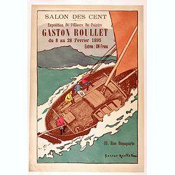
Salon des Cent, exposition de l'œuvre de Gaston Roullet du 8 au 28 février 1895.
Lithograph poster for the exhibition of the painter Gaton Roulet at Le Salon des Cent. The Salon des Cent (also known as “Salon des 100”, “Salon de La Plume”) is ...
- $1500 / ≈ €1275
Date: Paris, 1894-1895
Paris fashion plate. (3249E)
Uncommon Paris fashion plate from Le Moniteur de la Mode, under direction of Abel Goubaud.In the later quarter of the 19th century there was a proliferation of women's ma...
Date: Paris, 1896
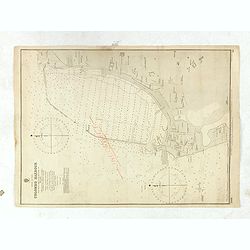
Colombo Harbour From Surveys supplied by Sir. John Coode. . .
Sir John Coode's highly detailed map of the Harbour at Colombo (Sri Lanka), with manuscript notations and corrections in pencil. With red pencil "INCORRECT".The...
- $500 / ≈ €425
Date: London, 1885 -1896
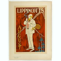
Lippincott's August.
Chromo lithographed poster, "Lippincott's August.", by CARQUEVILLE, W. Plate 132, published in Maître 17, on April 1896. The "Les Maîtres de l'affiche&qu...
Date: Paris, Imprimerie Chaix, April 1896
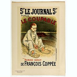
Le Coupable.
Chromo lithographed poster, "Le Coupable.", by STEILEN, A. Plate 134, published in Maître 17, on April 1896. The "Les Maîtres de l'Affiche" containe...
Date: Paris, Imprimerie Chaix, April 1896
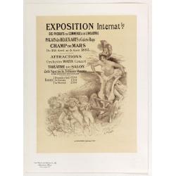
Exposition Internationale des produits du commerce . . .
Chromo lithographed poster, "Exposition Internationale des produits du commerce . . .", by WILETTE, A. Plate 142, published in Maître 17, on April 1896. The &q...
Date: Paris, Imprimerie Chaix, April 1896
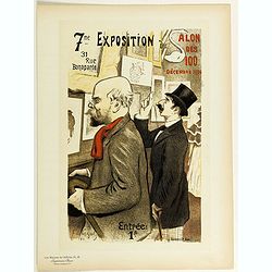
7eme Exposition du Salon des 100.
Chromo lithographed poster of Les Maîtres de l'Affiche being plate n°15. The "Les Maîtres de l'Affiche" contained 256 small for lithographic prints of the be...
Date: Paris, Imprimerie Chaix, 1896
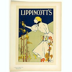
Lippincott's, May.
Chromo lithographed poster of Les Maîtres de l'Affiche being plate n°44. The "Les Maîtres de l'Affiche" contained 256 small for lithographic prints of the be...
Date: Paris, Imprimerie Chaix, 1896
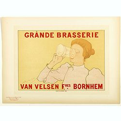
Grande brasserie . . .
Chromo lithographed poster of Les Maîtres de l'Affiche being plate n°12. The "Les Maîtres de l'Affiche" contained 256 small for lithographic prints of the be...
Date: Paris, Imprimerie Chaix, 1896
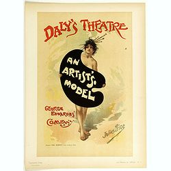
An Artist's Model.
Chromo lithographed poster of Les Maîtres de l'Affiche, being plate n°3. The "Les Maîtres de l'Affiche" contained 256 small lithographic prints of the best p...
Date: Paris, Imprimerie Chaix, 1896
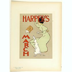
Harper's, March.
Chromo lithographed poster of Les Maîtres de l'Affiche being plate n°20. The "Les Maîtres de l'Affiche" contained 256 small for lithographic prints of the be...
Date: Paris, Imprimerie Chaix, 1896
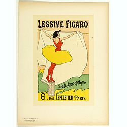
Lessive Figaro.
Chromo lithographed poster of Les Maîtres de l'Affiche being plate n°71. The "Les Maîtres de l'Affiche" contained 256 small for lithographic prints of the be...
Date: Paris, Imprimerie Chaix, 1896
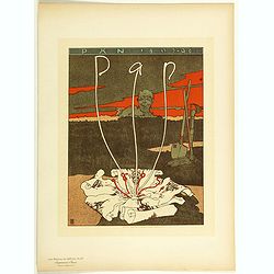
Pan.
Chromo lithographed poster of Les Maitres de l'Affiche n°67. The "Les Maitres de l'Affiche" contained 256 small for lithographic prints of the best posters of ...
Date: Paris, Imprimerie Chaix, 1896
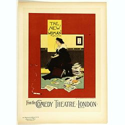
The new woman . . .
Chromo lithographed poster of Les Maitres de l'Affiche n°79. The "Les Maitres de l'Affiche" contained 256 small for lithographic prints of the best posters of ...
Date: Paris, Imprimerie Chaix, 1896
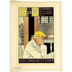
Geography Humphrey . . .
Chromo lithographed poster of Les Maitres de l'Affiche n°76. The "Les Maitres de l'Affiche" contained 256 small for lithographic prints of the best posters of ...
Date: Paris, Imprimerie Chaix, 1896
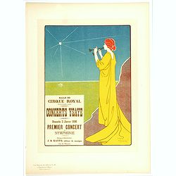
Concerts Ysaye . . .
Chromo lithographed poster of Les Maitres de l'Affiche n°40.The "Les Maitres de l'Affiche" contained 256 small for lithographic prints of the best posters of t...
Date: Paris, 1896
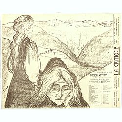
Theatre program for : Peer Gynt. Poëme dramatique en 5 actes d'Henrik Ibsen.
Theatre program for "Peer Gynt (poème dramatique en cinq actes d’Henrik Ibsen", 1896. Lower left in stone: E Munch, lower right printed: L'OEUVRE: 22, Rue Tu...
Date: Paris, 1896
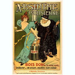
Absinthe Parisienne.
Chromolithograph advertising poster for the alcohol Absinthe Parisienne by Pierre-Henri Gelis-Didot (1853-?) & Louis Malteste (1862-1928). Printed by G. de Malherbe, ...
- $1100 / ≈ €935
Date: Paris, 1896
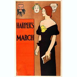
Harper's March.
Decorative advertising poster for Harper's Magazine. The poster shows a woman holding a Harper’s magazine in her left hand, though she does not read it. Dressed as if f...
- $750 / ≈ €637
Date: Paris, 1896
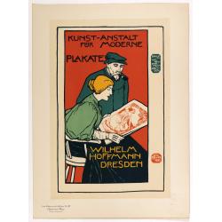
Wilhem Hoffmann Dresden.
Chromo lithographed poster, "Wilhelm Hoffmann Dresden.", after Otto Fischer. Plate 127, published in Maître 32, on July 1898. The "Les Maitres de l'Affich...
Date: Paris, Imprimerie Chaix, April 1896
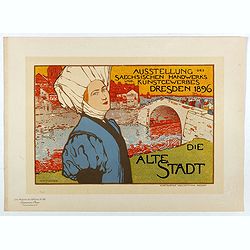
Die Alte Stadt.
Chromo lithographed poster, "Die Alt Stadt - Ausstellung des Saechsischen Handwerks und Kunstgewerbes Dresden 1896", by Otto Fischer. Plate 68, published in Mai...
Date: Paris, Imprimerie Chaix, April 1897
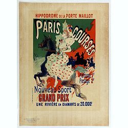
Hippodrome de la porte Maillot. Paris Courses.
Chromo lithographed mini poster, " Hippodrome de la porte Maillot. Paris Courses. Pelouse 1 f. pesage 2 f. Nouveau sport. Grand prix : une rivière en diamants de 20...
Date: Paris, Imprimerie Chaix, April 1897
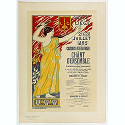
Concours international de chant . . .
Chromo lithographed poster, "Concours international de chant . . . .", by DONNAY, A. Plate 59, published in Maître 15, on Fébruary 1897. The "Les Maitres...
Date: Paris, Imprimerie Chaix, April 1897
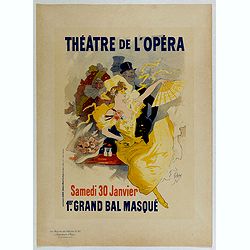
Théâtre de l'Opéra.
Chromo lithographed poster, "Théâtre de l'Opéra.", by CHERET, Jules. Plate 57, published in Maître 15, on February 1897. The "Les Maitres de l'Affiche&...
Date: Paris, Imprimerie Chaix, February 1897
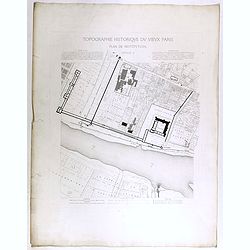
Topographie historique du vieux Paris / Plan de restitution Feuille V.
Copper engraved plan centered on Louvre by Jean-Joseph Sulpis (1826–1911) after a model by Adolphe Berty. Plate 5 from "Topographie historique du vieux Paris"...
Date: Paris, 1866-1897
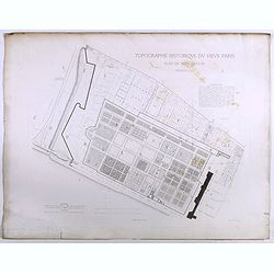
Topographie historique du vieux Paris / Plan de restitution Feuille V bis.
Copper engraved plan centered on gardens of the Louvre by Jean-Joseph Sulpis (1826–1911) after a model by Adolphe Berty. Plate 5bis from "Topographie historique du...
Date: Paris, 1866-1897
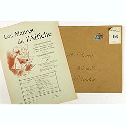
Sommaire du n°16 - Mars 1897
Cover of Les Maitres de l'Affiche n°16 (2nd year of publication). It used to contains the plates 61 - 64. The "Les Maitres de l'Affiche" contained 256 small fo...
Date: Paris, Imprimerie Chaix, August 1897
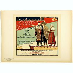
Rhodopsin Vistana Czechoslovakia 1895 . . .
Chromo lithographed poster of Les Maîtres de l'Affiche being plate n°56. The "Les Maîtres de l'Affiche" contained 256 small for lithographic prints of the be...
Date: Paris, Imprimerie Chaix, 1897