Browse Listings in America

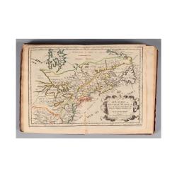
Connecticut and Parts adjacent at Amsterdam. .
A nice example of this early map of the state of Connecticut with part of Rhode Island to the east, Long Island to the south, and New York to the east. Rivers, roads, t...
- $30000 / ≈ €28072
Place & Date: Amsterdam, 1780

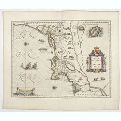
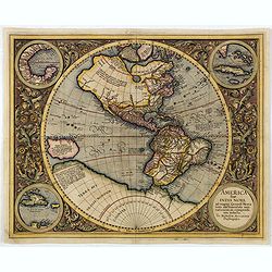
Americae Nova Descriptio.
Final state. According to Philip Burden, "this scarce map is America's first single-sheet map with decorative borders." A re-issue of the 1614 plate by Pieter v...
Place & Date: Amsterdam, 1652

A Map of the British Empire in AMERICA with the French, Spanish and Hollandish Settlements Adjacent Thereto. by Henry Popple. / Nouvelle Carte Particuliere de L'Amerique . . .
The four sheet Dutch edition of Popple's monumental map of North America, in mint condition. Encompassing the West Indies, Florida, Louisiana, Texas and Central America.T...
Place & Date: Amsterdam, ca. 1737

Carte D'Amerique Divisée en ses Principaux Pays. . .
Rare. Uncommon and decorative wall map of America, prepared by Clouet. With superb decorative borders, 170mm wide at the sides and 150mm at the bottom, containing twenty ...
Place & Date: Paris, Cadiz, 1785

Maris Pacifici.
From the rare Dutch text edition of the Theatrum of which according to van den Broecke only 100 copies are printed.This was the first printed map to be devoted solely to ...
Place & Date: Antwerp, 1598

Le Isole di Sandwich delineate sulle osservazioni del Cap Cook.
FIRST EDITION on laid paper. Cassini’s splendid map depicts Sandwich islands, old name for Hawaii islands, at the end of the eighteenth century. The splendid cartouche ...
Place & Date: Rome, 1798

Occidentalis Americae partis.
The most beautifully engraved early map of the Caribbean, including Florida and the Southeast. The map includes representations of Columbus' ships and various notes regar...
Place & Date: Frankfurt, 1594

Americae Pars Magis Cognita. Chorographia nobilis & opulentae Peruanae Provinciae, atque Brasiliae, . . . MDXCII
First state. Although a map of South America it does include much of what is now the southern United States. There are two elaborate, strap-work cartouches with the one a...
Place & Date: Frankfurt, 1592

New Yok entworfen von D.F. Sotzmann. Hamburg bey Carl Ernst Bohn 1799 . . . NO.VII
An extremely rare map of New York prepared by Daniel Friedrich Sotzmann for Christopher Ebeling's "Erdbeschreibung von Amerika", a project ended after only ten ...
Place & Date: Hamburg, Carl Ernst Bohn, 1799

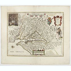
Novi Belgii novae que Angliae nec non partis Virginiae..
The third state with Fort Kassimier and Philadelphia and nearby placenames added. To the south the Dutch colony of Nieu Amstel. New nomenclature and a key appear around t...
Place & Date: Amsterdam, 1684

Americae Sive Novi Orbis, Nova Descriptio.
This is the second copperplate of Ortelius' map showing the western hemisphere, showing the prominent bulge in the South American coastline. An important map because of i...
Place & Date: Antwerp, 1579

New Jersey entworfen von D.F. Sotzmann. Hamburg bey Carl Ernst Bohn 1796 . . . NO.VIII
Extremely rare map of New Hampshire prepared by Daniel Friedrich Sotzmann for Christopher Ebeling's "Erdbeschreibung von Amerika", a project ended after only te...
Place & Date: Hamburg, Carl Ernst Bohn, 1797

Rhode Island entworfen von D.F. Sotzmann. Hamburg bey Carl Ernst Bohn 1798 . . . NO.V
Extremely rare map of Rhode Island prepared by Daniel Friedrich Sotzmann for Christopher Ebeling's "Erdbeschreibung von Amerika", a project ended after only ten...
Place & Date: Hamburg, Carl Ernst Bohn, 1797

Recueil de divers voyages faits en Afrique et en l'Amerique, qui n'ont point esté encore publiez.
First edition of this collection of significant and interesting voyages, edited by a scholar and book collector who served in the employ of Louis XIV before being appoint...
Place & Date: Paris, Louis Billaine, 1674

Belgii novi, angliae novae, et partis Virginiae . . .
This example is state 3 of the original Janssonius plate, printed after Schenk acquired the plates at public auction in 1694 from the heirs of Jansson van Waesberge. The ...
Place & Date: Amsterdam, 1694

(Totius Americae nova et exacta tabula ex) optimis tum geographorum tum aliorum scriptis collecta et ad hodiernam regnorum principatuum et maiorum partium distinctionem accomodata.
Eastern part of a two-sheet map of America, with attribution to Willem Blaeu. According to Philip Burden, the map was derived from Cornelius Danckert's 1647 map of the sa...
Place & Date: Rome, 1679
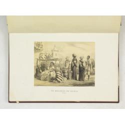
(Album Pallière. Escenas Americanas. Reduccion de Cuadros, aquarelles y bosquejos.)
51 (of 52 )beautifully lithographed plates on tinted ground, lithographed by J. Pelvilain after designs by Juan Léon Palliere. One plate missing : santiagueña tejiendo ...
- $10000 / ≈ €9357
Place & Date: Buenos Aires, en venta en la casa de los S.res Fusoni H.nos, ca. 1850
![[Printed on silk] Nova Totius Americae Sive Novi Orbis Tabula, Auct. Hugo Allardt.](/uploads/cache/48420-250x250.jpg)
[Printed on silk] Nova Totius Americae Sive Novi Orbis Tabula, Auct. Hugo Allardt.
Hugo Allard’s ca. 1661 map of the Americas, showing California as an island printed on silk. This separately issued map printed on paper is quite rare on the market. T...
Place & Date: Amsterdam, 1661

A plan of the City and Environs of Philadelphia. . .
The Lotter edition of Scull & Heap's seminal Philadelphia map, which map was first issued in 1752.Holmes' grid plan for the city is shown, situated between the rivers...
Place & Date: Augsburg, 1777

Carte des côtes du Golfe du Mexique compris entre la pointe sud de la presqu'Ile de la Floride et la pointe nord de la presqu'Ile d'Yucatan: Dresée d'après le observations et las plans des espagnols, ...
Detailed and important early chart of the Gulf Coast and Florida and dated 1800. First French edition of "the first printed [map] to show and name Galveston Bay&qu...
Place & Date: Paris, 1800

Pascaerte vande Caribische Eylanden, vande Barbados tot aende Bocht van Mexico ‘t Amsterdam By Hendrick Doncker. . .
First state. Rare. “This chart appeared in the first edition of Hendrick Doncker’s Zee-Atlas, of which no surviving example is known” -- Burden. This is an example ...
Place & Date: Amsterdam, 1659

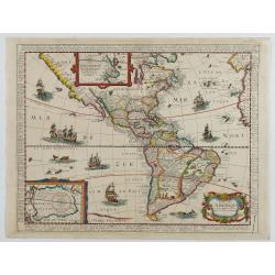
Americae Nova Tabula.
An inset shows Greenland and Iceland. Decorative elements include ships, sea monsters, and vignettes of native Americans within South America. In addition, the map is bor...
- $7500 / ≈ €7018
Place & Date: Amsterdam, 1644

A Map of the most Inhabited part of New England containing the Provinces of Massachusetts Bay and New Hampshire, with the Colonies of Connecticut and Rhode Island.
A copper engraving in four sheets, published in Georges Louis Le Rouge, in his "Atlas Ameriqua in Septentrional Contenant les details des differentes provinces, de c...
Place & Date: Paris, 1777

Naaukeurige Platte Grond van den Staat en den Loop van Rio de Berbice Met derzelver Plantagien in de Geoctrojeerde Colonie de Berbice Gelegen. . .
Uncommon large-scale map of Berbice with Rio de Berbice and Rio de Canjewith at the bottom left a list of plantation owners. In top 3 x 3 coats of arms in cartouches. The...
Place & Date: Amsterdam, 1742

Carolinae Floridae nec non Insularum Bahamensium cum partibus adjacentibus delinatio ad Exemplar Londinense in lucem edita . . . Ao. 1755.
The German edition of this map of Carolina, Florida, and the Bahama Islands in full original colors. Published in Seligmann's "Sammlung verschiedener auslaendischer ...
Place & Date: Nuremberg, 1755
![Le Isole di Sandwich delineate sulle osservazioni del Cap Cook. [Hawaii]](/uploads/cache/43195-250x250.jpg)
Le Isole di Sandwich delineate sulle osservazioni del Cap Cook. [Hawaii]
FIRST EDITION on laid paper. Cassini’s splendid map depicts Sandwich islands, old name for Hawaii islands, at the end of the eighteenth century. The splendid cartouche ...
Place & Date: Rome, 1798
![Amerique Septentrionale divisée en ses principales parties. . .1685. [California as an Island]](/uploads/cache/60628-250x250.jpg)
Amerique Septentrionale divisée en ses principales parties. . .1685. [California as an Island]
Engraved by Cordier. Spectacular example of Jaillot's map of North America, showing California as an Island, based upon Sanson's landmark map of 1656. This map shows the ...
Place & Date: Paris, 1685
![ISLA DE CUBA [with 2 maps] Plano Pintoresco De La Habana con los numeros de las casas B. May y Ca. 1853. (with) Inset map Puerto y Cereanias De La Habana. (with) 14 views of Havana & prominent buildings.](/uploads/cache/36720-250x250.jpg)
ISLA DE CUBA [with 2 maps] Plano Pintoresco De La Habana con los numeros de las casas B. May y Ca. 1853. (with) Inset map Puerto y Cereanias De La Habana. (with) 14 views of Havana & prominent buildings.
Lithographic town-plan surrounded with views of the city of Havana including the "Fuente De La India En El Paseo De Isabel 2a." and "Vista Gral De La Haban...
Place & Date: Havana, 1853

Americae Nova Tabula.
The delineation of the coast and the nomenclature on both the Pacific and Atlantic coasts are basically Spanish in origin and follow the maps of Ortelius and Wytfliet. To...
- $7500 / ≈ €7018
Place & Date: Amsterdam, 1645

Histoire de la Guerre Civile en Amerique par M. Le Comte de Paris, Ancien Aide de Camp du General Mac Clellan (McClellan). ...
These 30 maps were made by Vorzet to accompany Louis Phillipe d'Orleans' (Comte de Paris) multi volume "Histoire de la Guerre Civile en Amérique". The set incl...
Place & Date: Paris. Michel Levy Freres, 1875
![Hanc Tabulam continens Laetam Pharnambuci.. . [Brazil].](/uploads/cache/16521-250x250.jpg)
Hanc Tabulam continens Laetam Pharnambuci.. . [Brazil].
An extremely rare and decorative map of coast-line of Pernambuco. With one inset: In the upper left corner a map of Brazil, with title in five lines Dutch and five lines ...
Place & Date: Amsterdam, 1630

Mapa geogra´fico de la mayor parte de la Ame´rica Meridional que contiene los paises por donde debe trazarse la li´nia divisoria que divida los dominios de Espan~a y Portugal. . .
Rare first edition of the map drawn by Francisco Requena (1743-1824) after his expedition to the Amazon in order to delineate the boundary between the Spanish and Portugu...
Place & Date: Bourquin, F. Philadelphia, ca. 1876

Carte d'une Partie des Cotes de la Floride et de la Louisiane, Contenant le Cours du Mississipi...
A well engraved and highly detailed chart of part of the Gulf Coast, dated 1778 that was issued in Neptune americo-septentrionale. The chart covers the area between St. J...
Place & Date: Paris, 1778-1780

The Harbour of Casco Bay and Islands Adjacent Bt Capt. Cyprian Southicke.
The earliest printed chart of Casco Bay, an inlet of the Gulf of Maine on the southern coast of Maine, New England. First issued in 1720 by Mount and Page, it remained in...
Place & Date: Dublin, 1767

.Pascaerte Vande Zuyd-Zee tusschen California, en Ilhas de Ladrones. . .
A decorative and most interesting map - being one of the earliest of the Pacific to record the observations of Tasman's voyages. The northern part of the island of Califo...
Place & Date: Amsterdam, 1666
L'Amerique, en plusieurs cartes nouvelles, et exactes, &c. En divers traitez de geographie, et d'histoire. Là où sont descrits succinctement, & avec une belle Methode, & facile.
Third edition, the text and maps of which are identical to the first given in 1657. However, the dedication to Nicolas Fouquet (2 pp.), disgraced in 1661, has been delete...
- $4500 / ≈ €4211
Place & Date: Paris, 1680

Pascaerte van Brazil en Nieu Nederlandt van Cuorvo en Flores.
A rare chart of the Atlantic Ocean from the first edition of Hendrick Doncker's Zee-Atlas, of which no surviving example is known.Although the idea of its unusual coverag...
Place & Date: Amsterdam, 1658

The Traveller's Guide. A Map Of The Roads, Canals And Steam Boat Routes Of The United States ... Designed for the use of Travellers, By H.S. Tanner.
Rare first edition of Tanner's travel map in pocket map form, in it original red leather covers, with the map and no text, as issued. Ristow says the first edition was 18...
Place & Date: Philadelphia, 1825

Nova Virginiae Tabula.
A fine example of Blaeu's map of Virginia and the Chesapeake region is based on the first state of Smith's map, 1612, and is slightly larger and more expertly engraved.Th...
Place & Date: Amsterdam, 1640

Poli Arctici, et circumiacentium terrarum descriptio novissima. . .
A re-issue of the Hondius' plate. A particularly decorative map of the North Pole with Iceland. Several Dutch names in Labrador. The toponymy in Canada reflects the conti...
Place & Date: Amsterdam, 1660

Insulae Americanae in Oceanus Septentrionali cum Terris..
General map of the West Indies extending from Virginia to the mouth of the Orinoco, and destined to be copied in various shapes by many other publishers. Title cartouche ...
Place & Date: Amsterdam, 1647

L'Amérique divisée en ses principaux Etats Dressée d'après les Cartes de Mr. Bonne?
Rare, wall map of America in 2 sheets, after R. Bonne. With 3 inset maps of Hispaniola, Martinique and Hudson Bay. Beautiful title cartouche depicting a Native American l...
Place & Date: Paris, 1788
![Posesiones de America : Isla de Cuba. [together with] Isla de Cuba. . .](/uploads/cache/23458-250x250.jpg)
Posesiones de America : Isla de Cuba. [together with] Isla de Cuba. . .
Wall size sea chart and map of land areas showing all of Cuba, part of Florida Keys plus San Adios and Salvador Grande in the Bahamas.Minute topographical, political, and...
Place & Date: Madrid, 1853 / 1851
![Amerique Septentrionale divisée en ses principales parties. . .1692. [California as an Island]](/uploads/cache/27961-250x250.jpg)
Amerique Septentrionale divisée en ses principales parties. . .1692. [California as an Island]
A very good impression of Jaillot's large map of North America, showing California as an Island, based upon Sanson's landmark map of 1656. A first state.The map shows the...
Place & Date: Amsterdam, c.1692

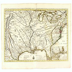
Carte de LA LOUISIANE et des PAYS VOISINS Dédiée a M. Rouillé Dediee a M. Rouille Secretairr 'd Etat ayant le Departement de la Marine... 1750
North America from the eastern seaboard to the Rocky Mountains. Based on Delisle's map of 1718 with additions from notes compiled by the Jesuit priest, explorer and histo...
Place & Date: Paris, 1750

Mar del Zur, Hispanis Mare Pacificum.
Janssonius' fine chart of the Pacific including the west coast of America with California shown as an island, Japan and a small Australian coastline. This is the earliest...
Place & Date: Amsterdam, 1650

Cunard Cherbourg-New York.
Original vintage Cunard luxury cruise liner travel poster advertising Cunard Europe to all America fastest ocean service in the world. Stunning design featuring two color...
Place & Date: England, ca. 1930
Nova Belgica et Anglia Nova.
Orientated with north to the right. This is one of the earliest maps to concentrate solely on this area of the colonies, excluding Virginia and the extreme north east coa...
- $4500 / ≈ €4211
Place & Date: Amsterdam, 1644
![Mexico, Regia et Celebris Hispaniae Novae Civitas ... [on sheet with] Cusco, Regni Peru in Novo Orbe Caput.](/uploads/cache/29013-250x250.jpg)
Mexico, Regia et Celebris Hispaniae Novae Civitas ... [on sheet with] Cusco, Regni Peru in Novo Orbe Caput.
Two bird's-eye views on one sheet: Mexico and Cusco.Showing Mexico City and Cusco, the capital cities of the Aztecs and Incas, with the major buildings shown in profile w...
Place & Date: Amsterdam, 1657

Carte des Possessions Françoises et Angloises dans le Canada et partie de la Lousiane. . .
Proof state. Here without the decorations around the title cartouche in the what is called in the reference books the first state the cartouche in upper left . No double ...
Place & Date: Paris, 1756

Pas-kaart vande Zee kusten van Venecuela met de Byleggende Eylanden. . .
Rare chart of the coast of Venezuela, including the islands of Curaçao, Bonaire, Aruba, etc.The chart has two insets, one (15x22cm) with a map of Curaçao, one smaller w...
Place & Date: Amsterdam, 1680

Mappa Aestivarum Insularum alias Barmudas.
Blaeu based his work on John Speed's remarkably accurate map of 1626-1627. It shows the island divided into tribes and lots, and below the map itself appear the names of ...
Place & Date: Amsterdam, 1635

French Line CGT Poster.
French Line CGT Poster showing the Normandie cruise ship travelling from Southampton to New York, advertising an express luxury service on both the Ile de France and the ...
Place & Date: England, ca. 1936

A new map of the English Empire in America. . .
This fine English map of eastern North America including Canada engraved by John Harris and first published by Robert Morden. John Senex acquired and made minor alteratio...
Place & Date: London, 1720

Novissima et Accuratissima Totius Americae Descriptio.
Second state of Visscher's map of the Americas, this decorative map greatly influenced the cartography of the Americas both geographically and artistically.Although it di...
Place & Date: Amsterdam, 1677

North Pacific.
Huge three sheet so-called Blue-back sailing chart of the Northern Pacific including China, Korea (with Matu Is. and Liancourt), Japan, Philippines, Kamchatka, Hawaii, Al...
Place & Date: London, 1868
![A Toopapaoo of a Chief, with a priest making his offering to the Morai, in Huoheine. [Huaheine - the Society Islands]](/uploads/cache/30045-250x250.jpg)
A Toopapaoo of a Chief, with a priest making his offering to the Morai, in Huoheine. [Huaheine - the Society Islands]
A view of a chief's raised burial chamber in Huaheine, Society Islands, taken from "Views in the South Seas" being a very important and early view depicting sce...
Place & Date: London, Boydell and Co., 1808

Nova tabula geographica complectens borealiorem..
A finely engraved pair of maps designed to be cut and joined together to provide a continuous coastline of North America from the Carolinas to Newfoundland and along the ...
Place & Date: Amsterdam 1720
![The Coast of New Found Land From Salmon Cove to Cape Bonavista. . . [together with] The Coast of New Found Land from Cape-Raze to Cape St-Francis.](/uploads/cache/40658-250x250.jpg)
The Coast of New Found Land From Salmon Cove to Cape Bonavista. . . [together with] The Coast of New Found Land from Cape-Raze to Cape St-Francis.
Two charts showing the coast of New Found Land from Salmon Cove to Cape Bonavista and from Cape-Raze to Cape St-Francis. With inset chart of Trinity HarborGrierson publis...
Place & Date: Dublin, 1767

Archipelague du Mexique ou sont les Isles de Cuba..
Scarce map of Caribbean. A visually stunning map with a large title cartouche. This large one-sheet map was produced by the Venetian cosmographer Vincenzo Coronelli when ...
Place & Date: Paris, 1688

Carte Réduite Des Côtes Orientales De L' Amérique Septentrionale Contenant Partie du Nouveau Jersey.. Virginie.. Georgie..
Uncommon chart that extends from Delaware Bay and Philadelphia south through much of Georgia to Island Amelia and St. Johns River. Fleur-de-lis and rhumb lines fill the s...
Place & Date: Paris, 1778

Carte Réduite Du Golphe Du Mexique Et Des Isles De L' Amérique..
A well engraved and highly detailed chart prepared by Bellin of the Gulf of Mexico and the Caribbean. In addition to a magnificent title cartouche and a color key to the ...
Place & Date: Paris dated year 17, or 1808

Rooseveld rekende verkeerd ! De vangarmen van De Dollarpoliep worden afgesneden. . .
An remarkable Anti-American Dutch World War II propaganda poster by Lou Manche, showing an pink octopus, representing the United States, with its tentacles being cut from...
Place & Date: The Netherlands, 1942
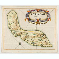
Curacao Eylandt.
One of the earliest separate maps of Curaçao. The map has nice topographical detail and features an ornate title cartouche. Published in de Laet's account of the history...
Place & Date: Amsterdam, 1644
America sive India Nova.
This map was created by Michael Mercator, grandson of the great Gerard Mercator. It is the only map attributed to him. The map first appeared in 1595, one year after the ...
- $3000 / ≈ €2807
Place & Date: Amsterdam, 1630

Nieuwe Wassende Graadige Pas-kaart van de Kust van Guinea en Brasilia.
Rare two-sheet sea chart of the coasts of Brazil, West Africa and South Africa, published by Johannes Van Keulen (the younger), circa 1720.The chart shows the western coa...
Place & Date: Amsterdam, 1751
Nova Virginiae Tabula.
The map is based on the first state of Smith's map, 1612, and is slightly larger and more expertly engraved. In 1629 the Hondius plate was purchased by Blaeu who deleted ...
Place & Date: Amsterdam, 1644
Carte de L'AMERIQUE Corrigeé et argumenteé….
Separately published map published in 1658 but based on Petrus Bertius map of 1624., this on its turn taken from Jodocus Hondius map of 1618. On the sides he lists the pr...
Place & Date: Paris, 1658

Carte des Possessions Françoises et Angloises dans le Canada, et partie de la Louisiane.
First state of this separately published map of the European Colonies in the New World east of the Mississippi River. This map was published in 1756 to provide informatio...
Place & Date: Paris, 1756
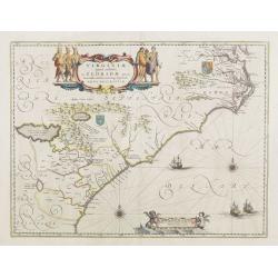
Virginiae Partis Australis, et Floridae Partis Orientalis.
Blaeu based this map on the Mercator-Hondius of 1606. A number of geographical improvements, however were incorporated, although two large fictions lakes accompanied by e...
Place & Date: Amsterdam, 1640

Virginiae Partis Australis, et Floridae Partis Orientalis.
Blaeu based this map on the Mercator-Hondius of 1606. A number of geographical improvements, however were incorporated, although two large fictions lakes accompanied by e...
Place & Date: Amsterdam, 1640

Guyana, Surinam, Amapa.
Very rare Ottoman printed map of Guyana, Suriname and Amapa. With Trinidad, an inset map of the mouth of the Rivers Essequibo, Courantyne, Suriname with Paramaribo.From C...
Place & Date: Üsküdar (Istanbul), 1803
![A Map of the United States and Canada, New-Scotland, New-Brunswick and New-Foundland ... [together with] A Map of the West-Indies and of the Mexican-Gulph...](/uploads/cache/39235-250x250.jpg)
A Map of the United States and Canada, New-Scotland, New-Brunswick and New-Foundland ... [together with] A Map of the West-Indies and of the Mexican-Gulph...
A Map of the United States and Canada, New-Scotland, New-Brunswick and New-Foundland / Carte des Etats Unis, avec Le Canada, la Nouvelle Ecosse, le Nouveau Brunswick &...
Place & Date: Paris, 1806

Carte de la Nouvelle France, ou se voit le cours des Grandes Rivieres de S. Laurens & de Mississipi..
Derived from de Fer's 1718 map, from west of the Mississippi it contains a mass of inland detail with notes and vignettes of the indigenous peoples and fauna of North Ame...
- $2700 / ≈ €2526
Place & Date: Amsterdam, 1720

Nieuwe Wassende Graade Zee Kaart over de Spaanse Zee Vant Kanaal tot 't Eyland Cuba in Westindia. . .
¤ Engraved by I.van Anse. A very representative example of a Dutch chart of the Atlantic, showing the north-east coast of America, the coasts of Africa and Europe and So...
Place & Date: Amsterdam, 1728

Amérique Septentrionale .. Les Etats Unis..
Very rare state: probably separately issued. Published the same year the Treaty of Paris was signed, this is one of the first maps to provide printed boundary lines for t...
- $3000 / ≈ €2807
Place & Date: Paris, 1786

Nova Virginiae tabula.
A fine example of Blaeu's map of Virginia and the Chesapeake region is based on the first state of Smith's map, 1612, and is slightly larger and more expertly engraved.Th...
Place & Date: Amsterdam, 1635/1660

Nader prolongatie van het Octroy voor de Westindische Compagnie voor den tyd van nog dertig jaaren. . .
A proclamation by the Dutch States General, dated 1761, extending the charter of the Dutch West India Company for another thirty years. Like the 1730 proclamation, it has...
Place & Date: Amsterdam, 1761

Stoel des Oorlogs in America Waar in Vertoont Werden Alle Desself Voornaamste Eylande . . .
Large impressive map of the West Indies with the Gulf of Mexico and Florida. The map shows prominently in the center Cuba, Haiti, the Bahamas and Florida, which is here m...
Place & Date: Amsterdam, c. 1720
Carte de la Louisiane et du Cours du Mississipi Dressée sur un grand nombre de Memoires..
Covens & Mortier's issue of Delisle's influential map of the French possession of Louisiana. Updated to include New Orleans. When originally published in 1718, it was...
- $2400 / ≈ €2246
Place & Date: Amsterdam, c. 1745