Browse Listings in America
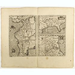
La Florida/ Peruviae Auriferae regionis Typus/ Guastecan.
The Chaves map of Florida is a prime example of an explorer's map since it records the recent discoveries of Cabeza de Vaca, De Soto, and Moscoso. The map revealed little...
Place & Date: Antwerp, 1598
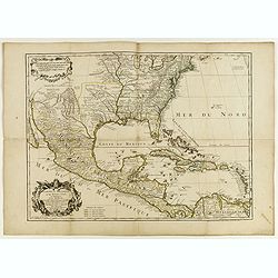
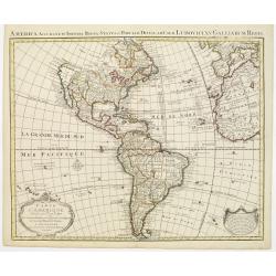
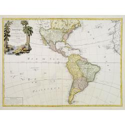
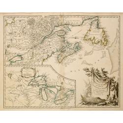
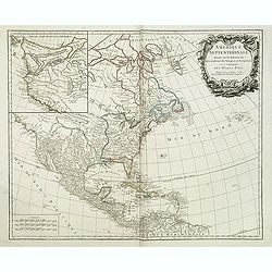
Carte du Mexique et des Etats Unis d'Amérique...
A later edition of De l'Isle's foundation map of 1703, widely regarded as one of the most influential maps in the history of American Cartography. This updated version of...
Place & Date: Paris, 1783
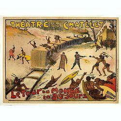
Théâtre du Châtelet. Le Tour du Monde en 80 jours. (The attack of the train).
Theatre poster for "Around the World in Eighty Days by A. Dennery and Jules Verne, for Théâtre du Châtelet, Paris. Printed by : Imprimerie Ch. Wall et Cie, 14 rue...
- $1200 / ≈ €1123
Place & Date: Paris, Imp. Ch. Wall et Cie, ca.1900-1914
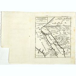
Un Passaggio per Terra a California Scoperto dal P. Eusebio Francesco Kino Gesuita Fragli Anni 1698 et 1701.
The rare Italian edition of Father Eusebio Francisco Kino's seminal map, which definitively ended the myth of California as an Island, which appeared in Saggio delle tran...
- $1200 / ≈ €1123
Place & Date: Napples, 1731
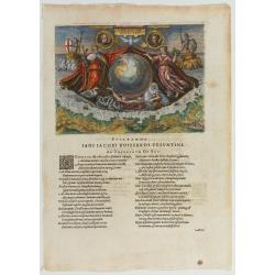
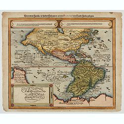
Americae Retectio (Allegory of the Discovery of America)
Allegorical scene commemorating the discovery of America. The main image shows Neptune, supporting a Globe, flanked by Flora-representing Florence, and Janus-representin...
- $1000 / ≈ €936
Place & Date: Frankfurt, 1594
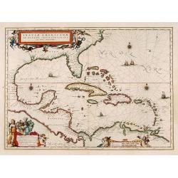
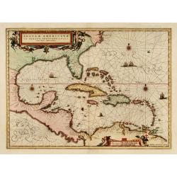
Insulae Americanae in Oceano Septentrionali cum Terris adiacentibus.
General map of the West Indies extending from Virginia to the mouth of the Orinoco, and destined to be copied in various shapes by many other publishers. Title cartouche ...
- $1000 / ≈ €936
Place & Date: Amsterdam, 1635
![Noweav Mexiqve [California as an Island]](/uploads/cache/03796-250x250.jpg)
Noweav Mexiqve [California as an Island]
Uncommon miniature map of California as a island, from Pierre Duval's La Geographie Universeille in a second state. The map is derived from Audience de Guadalajara (1657)...
Place & Date: Paris, 1663

Géographie des Plantes Equinoxiales - Tableau physique des Andes et pays voisins. . .
Physical Portrait of the Andes and adjacent lands", organized around the Chimborazo and Cotopaxi volcanoes in Ecuador.With local vegetation is illustrated pictoriall...
- $1000 / ≈ €936
Place & Date: Paris, 1805
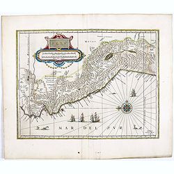
Peru.
FIRST EDITION, FIRST ISSUE OF THIS MAP. Decorated with ships and monsters in the sea. Orientated with east at the top. With the signature of G. Blaeuw lower right corner....
- $1000 / ≈ €936
Place & Date: Amsterdam, 1644

A new & accurate map of Louisiana, with part of Florida. . .
An English view of North America compiled from available French maps, especially those of Bellin used in Charlevoix's History of New France. English cartographers had lit...
- $1000 / ≈ €936
Place & Date: London, 1744
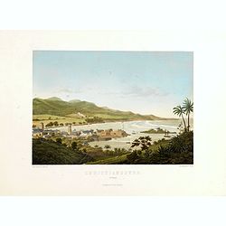
Christianssted. (St.Croix).
A beautiful view of the small town of Christiansted on the island of St. Croix. This view shows much of the harbour and a portion of the town's waterfront. one of a serie...
- $900 / ≈ €842
Place & Date: Copenhagen, Baerentzen & Co, 1856

Nieuwe Kaart van de Grootbrittannische Volkplantingen in Noord America waar in Tevens de Fransche Bezittingen en de Landen tuschen die Beide Volken. . .
A map of the east-coast of America from New Foundland till Florida, divided in French and British properties. Reduced size Dutch edition of Mitchell's map of North Americ...
Place & Date: Amsterdam, 1769

Ilse Paese de' Selvaggi.. Lago Superiore. (Florida and the Bahamas)
Antonio Zatta published an Italian version of the John Mitchell map in twelve sheet. This sheet depicts Lake Superior in the Bellin version, as it appeared on the Mitchel...
Place & Date: Venice, 1778
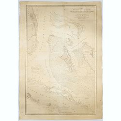
Carta del Gran Banco de Bahama parte de la Isla de Cuba y Costa de la Florida.
A large marine chart, engraved by Juan Noguera and C.Marquerie, produced by the Direccion de Hydrografia, under the direction of Jose de Quesada, who was the then chief o...
- $1750 / ≈ €1638
Place & Date: Madrid, 1858-1866
![[Map of the Monterey Peninsula.]](/uploads/cache/48349-250x250.jpg)
[Map of the Monterey Peninsula.]
A lovely example of Jo Mora's Del Monte Properties Company' California's Fun' playground tourist map of the Monterey Peninsular, published in San Francisco in 1927. The r...
- $900 / ≈ €842
Place & Date: San Francisco, 1927
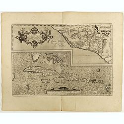
Culiacanae Americae regionis.. / Hispaniolae, Cubae..
Two virtually identically sized inset maps on one sheet, each with a decorative scroll title cartouche. Culiacanae depicts the coastal and inland western region in North ...
Place & Date: Antwerp, 1598
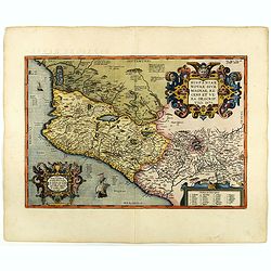
Hispaniae novae sive magnae recens et vera descriptio. 1579
This was the standard map of the area for a generation, copied by De Bry, Quad and Hondius. Even though Herrera (Spain's Royal Cosmographer) and Wytfliet worked 20 years ...
- $750 / ≈ €702
Place & Date: Antwerp, 1598
![[North America]](/uploads/cache/25907-250x250.jpg)
[North America]
Uncommon map of North America. The young United States incorporates the upper Midwest, with the remaining western territories of Louisiana, Nouveau Mexique, Nouveau Albio...
- $1000 / ≈ €936
Place & Date: Augsburg, ca. 1790

Driving chart of Hartford and vicinity : 15 miles around.
Road map by Albert A. Hyde & Co. of Hartford and vicinity, with the Connecticut River in the center. Published by Albert A. Hyde & Co., in New York and lithograph...
Place & Date: New York / Philadelphia, 1884

Dutton Map of the Grand Canyon, Arizona (in 4 joined sheets)
An important 1882 map of the Grand Canyon, Arizona, published in "Atlas To Accompany The Monograph On The Tertiary History Of The Grand Canon District By Capt. Clare...
- $1000 / ≈ €936
Place & Date: Julius Bien & Co., 1882
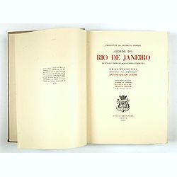
Cidade do Rio de Janeiro - Remodelação, Extensão e Embelezamento.
Important architectural book prepared by Antonio Prado Junior (1880-1955) under the general direction of Alfredo Agache ( 1875-1959) published by Foyer Brésilien editor,...
- $1100 / ≈ €1029
Place & Date: Foyer Brésilien editor, Paris, 1930
Insulae Americanae in oceano septentrionali..
Showing the Gulf of Mexico and the West Indian Islands, and the adjacent North and South American coastlines.The cartography is based on the rare Gerritz chart of 1631. T...
- $1000 / ≈ €936
Place & Date: Amsterdam, 1660

Tierra Nueva.
Uncommon first edition of this early map of the east coast is an enlarged version of Giacomo Gastaldi map published in 1548. Nomenclature and cartography are unchanged, w...
- $1000 / ≈ €936
Place & Date: Venice, 1561
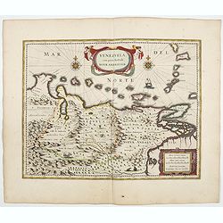
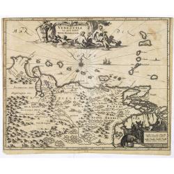
Venezuela cum parte Australi Novae Andalusiae.
A finely engraved, decorative map of Venezuela. The islands of Trinidad and Tobago, Margarita, Aruba and Curaçao are shown. Local animals are depicted, sheep, birds, mon...
- $1100 / ≈ €1029
Place & Date: Amsterdam, ca. 1644
L'Amerique septentrionale, Dressée sur les memoires les plus recens. . .
A very detailed map extending from Hudsons Bay to Panama, and including the West Indies. The map is a later copy of Guillaume de L'Isle's foundation map of North America,...
Place & Date: Amsterdam, 1739
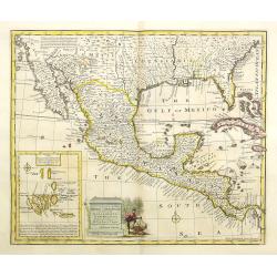
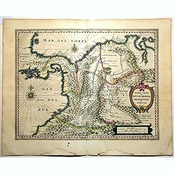
A new and accurate map of Mexico or New Spain with California New Mexico . . .
With inset of Galapagos islands. A wonderfully engraved map showing the entire American South from Carolina to California, as well as all of Mexico and Central America. A...
- $1100 / ≈ €1029
Place & Date: London, 1747
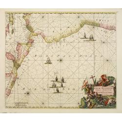
Nova Hispaniae, Chili, Peruviae, et Guatimalae Littorae..
A superbly decorative chart, oriented with north to the left of the sheet, covering the coasts of Central America, Peru, Chile, Jamaica and part of Cuba and Porto Rico. S...
- $1000 / ≈ €936
Place & Date: Amsterdam, 1660

New York Ferry Boat. (Bac à vapeur de New York).
A very decorative print showing the New York Ferry Boat "Fulton," published by Currier & Ives. The Ferry boat "Fulton" sails to the right. A singl...
Place & Date: New York, ca. 1875
![Noweav Mexiqve. [California as an Island]](/uploads/cache/26133-250x250.jpg)
Noweav Mexiqve. [California as an Island]
Scarce miniature map of California as a island, from Pierre Duval's La Geographie Universeille. The second earliest map to focus on just California and the contiguous coa...
- $800 / ≈ €749
Place & Date: Paris, 1672

Carte des Iles Hawaii.
A lovely small map of the complete chain of Pacific islands known today as the Hawaiian islands, from Dumont d'Urville's atlas "Voyage pittoresque autour du Monde.&q...
Place & Date: Paris, 1834
![Prospect des Plazes vor dem Rath Haus zu Boston. Vuë de la Rue et de la Maison de Ville a Boston. [together with] Prospect der König[lichen] ...](/uploads/cache/34214-250x250.jpg)
Prospect des Plazes vor dem Rath Haus zu Boston. Vuë de la Rue et de la Maison de Ville a Boston. [together with] Prospect der König[lichen] ...
Two so-called optical prints show a decorative imaginary view of the old state house, built in 1657, which was the center of government for the colony of Massachusetts an...
- $1500 / ≈ €1404
Place & Date: Augsburg, ca. 1776
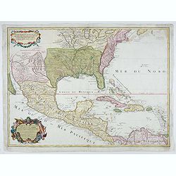
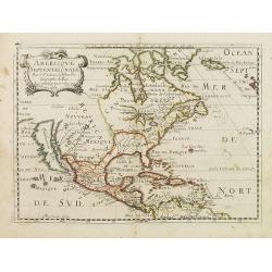
Carte du Mexique et des Etats Unis d'Amérique…
A later edition of De l'Isle's foundation map of 1703, widely regarded as one of the most influential maps in the history of American Cartography. This updated version o...
Place & Date: Paris, 1783
Americae Sive Novi Orbis, Nova Descriptio
Woodcut map by based on Abraham Ortelius' classic map of 1570, with the huge bulge in the southwest coastline of South America, the Ortelian western coastline of North Am...
Place & Date: Basel, ca. 1588
Plano de los Ferro-Carriles de Republica Argentina 1902.
Folding rail road map of Argentina, with inset of Buenos Aires in upper right corner.
Place & Date: Buenos Aires, ca. 1902

Carte qui contient..Iles & Terres..L'Amerique..Jamaique..
Eight maps on one sheet. From Chatelain's Atlas Historique et Méthodique . Including maps of Bermuda, Jamaica, New England with Long Island, Carolina, Chesapeake and Del...
Place & Date: Amsterdam 1728
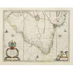
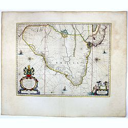
Brasilia.
A mint example of this map is by Krystof Arciszewski, a Polish general who worked for the Dutch West Indian Company. The map perpetuates various myths including the Parim...
- $1250 / ≈ €1170
Place & Date: Amsterdam, 1658
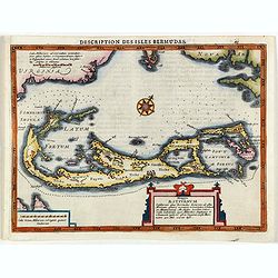
Description des Isles Bermudas.
Map of Bermuda from the rare Cloppenburg edition slightly larger format and more scarce edition of the Mercator/Hondius "Atlas Minor". Engraved by Pieter Van De...
- $800 / ≈ €749
Place & Date: Amsterdam, 1630
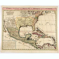
Carte contenant le Royaume du Mexique et la Floride.
This is a derivative of Delisle's landmark map of the southern part of North America.The detailed map shows many English settlements along the East Coast and carefully no...
- $1000 / ≈ €936
Place & Date: Amsterdam, 1719

Brasila.
Map of Brazil extending from C. Nasou and Parime Lago to the Mouth of the Rio de la Plata. Oriented with West on top.The cartography of the region is quite primitive. The...
Place & Date: Amsterdam, 1673
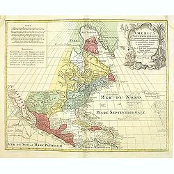
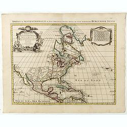
America Septentrionalis, Concinnata juxta Observationes..
This exemplar represents Lotter's version of Delisle's foundation map of North America, published in 1700. The Great Lakes show the French strong holds at Quebec, Montrea...
- $875 / ≈ €819
Place & Date: Augsburg, ca. 1770
Americae pars meridionalis.
Decorated with several ships and sea monsters, and a cartouche flanked by engravings of six Indians, netted hammocks and South American fauna.
- $1000 / ≈ €936
Place & Date: Amsterdam, 1650
Carte d' Amerique Dressee pour l'Usage Du Roy. . .
Detailed copper-engraved map of the American continent. Decorative title cartouche with foliate garland, and embellished lettering of d' Amerique. The western parts of Af...
- $1000 / ≈ €936
Place & Date: Amsterdam c. 1745
Freti Magellanici ac novi Freti vulgo Le Maire. . .
A fine map of Tierra del Fuego. With an explanatory text of the passage by Barent Jansz. Potgieter who accompanied captain Sebald de Weert to the Straits in 1599/1600, be...
- $750 / ≈ €702
Place & Date: Amsterdam, ca. 1633
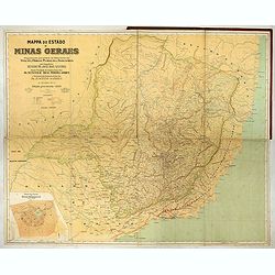
Mappa do estado de Minas Geraes.
Monumental map of the Minas Geraes State, the Brazilian Eldorado, with an inset plan of Belo Horizonte. Scale of 1 : 100 000. Lith. Hartmann-Reichenbach, 1910. Organized ...
- $1000 / ≈ €936
Place & Date: Rio de Janeiro, 1910 -1911
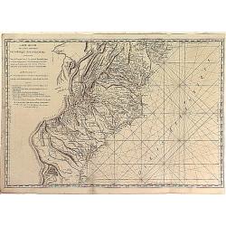
Carte Réduite des Côtes Orientales Del'Amérique Septentrionale Contenant partie du Nouveau Jersey, la Pen-sylvanie, le Mary-land, la Virginie, la Caroline Septentrionale, la Caroline Méridionale et la Georgie. . .
Scarce Rome edition of an French map made expressly for use of the French Navy during the American Revolution. Covering the area of Maryland, North and South Virginia. Ph...
- $900 / ≈ €842
Place & Date: Genova, Yves Gravier, c.1800
L'Amerique divisée en ses principaux Etats..
Uncommon map published by Lattré. This map is most notable for its depiction of "Mer de L'Ouest" or "Sea of the West". A great sea, easily the size o...
- $900 / ≈ €842
Place & Date: Paris, 1760
Novum Amsterodamum. . .
Three engravings on one page are set in a decorative, separately engraved border. - In the upper left is a good example of one of the earliest available views of New York...
- $1200 / ≈ €1123
Place & Date: Leiden, 1729
Tabula Magellanica.
A map with Willem Blaeu's signature, but published by his son Joan, of South America's extremity. A dedication to Constantijn Huygens. From early on Willem Jansz. Blaeu ...
- $1000 / ≈ €936
Place & Date: Amsterdam, 1644

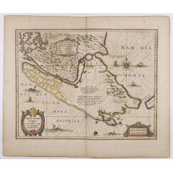
Plan der Stadt Quebec Haupstadt in Neu Franckreich oder Canada.
Town-plan of Quebec, with an inset view of the town in the lower right corner. In the upper right a recapitulation of the main military actions prior to the surrender of ...
Place & Date: Nurnberg, 1770
Partie de l'Amerique Septent ...
A fine copy of this map of New Foundland, Nova Scotia and the course of the St.Laurence to Lake Ontario. An inset shows Bellini's famous and important map of the Great La...
- $800 / ≈ €749
Place & Date: Paris, 1755

Carte des Isles d'Acores.
Uncommon and detailed map of the Azores. With inset maps of Port de St.Cruz and harbor and town of Angra on the island of Terceira. It was at the time an important port a...
Place & Date: Amsterdam, 1730

Carte Geo-Hydrographique du Golfe du Mexique et de ses Isles..
Map of the Caribbean and Gulf of Mexico showing the various islands and continental coastlines according to the 18th century Venetian cartography of Rizzi Zannoni.Illustr...
Place & Date: Paris, ca 1783
Terra Firma et Novum Regnum Granatense et Popayan.
A handsome map of modern-day Panama and Colombia. The cartouches and decoration are colored in an artistic way. Very fine and rare with this type of coloring.From "l...
Place & Date: Amsterdam, 1635-1638
Americque Septentrionale. . .
A general map of North America shows California as an island but with few names and a flat northern coastline. Prepared by N. Sanson and engraved by A.Peyrounin. A first ...
- $1000 / ≈ €936
Place & Date: Paris, P. Marriete, 1667

Yucatan . . . Et Guatimala Conventus Iuridicus.
Very attractive map encompassing the Mexican heartland, the Yucatan peninsula, and the old Spanish Audiencia of Guatemala including Honduras, Nicaragua, Costa Rica and pa...
Place & Date: Amsterdam, 1673
Americae sive Indiae Occidentalis.
Hessel Gerritsz. the author and probable engraver of the map had seen maps of California as an island, but he relies on the more trustworthy accounts, such as Herrera, in...
- $1000 / ≈ €936
Place & Date: Leiden, 1625

Les Isles Terceres. . .
Uncommon map of the Azores. Engraved by Sommer. Du Val is mentioned as the cartographer and the publisher was Pierre Mariette.
Place & Date: Paris, c. 1650 - 1676
AMERIQUE SEPTENTRIONALE dressée sur les Relations les plus modernes des Voyageurs et Navigateurs ou se remarquent LES ETATS UNIS. . .
This large map of North America and the West Indies was originally published in 1750: however after the Treaty of Paris recognized the United States in 1783 the map was '...
Place & Date: Paris, after 1786
Selling price: $750
Sold in 2011

L'Amerique Septentrionale.
Very rare map, from "Metaphaste Barbao, Descriptio Indiae Occidentalis et America Nova" published by Henrico Verdussen.The map is a copy of Guillaume de L'Isle'...
- $1250 / ≈ €1170
Place & Date: Antwerp, 1702
Virginiae item et Floridae . . .
Map of Virginia from the rare Cloppenburg edition slightly larger format and more scarce edition of the Mercator/Hondius "Atlas Minor". Engraved by Pieter Van D...
- $750 / ≈ €702
Place & Date: Amsterdam, 1630
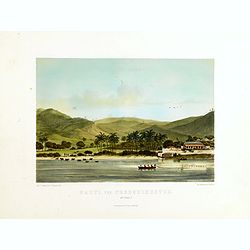
St. Thomas (parti af Byen og Havnen).
A beautiful view of the harbour on the island St. Thomas. This view shows much of the town, bay and surrounding area. One of a series of six lithographs of St. Thomas pro...
- $1100 / ≈ €1029
Place & Date: Copenhagen, Baerentzen Co, 1856

Paraquariae Provinciae Soc. Iesu cum Adjacentibus Novissima...
Between the years of 1609 and 1780, the Jesuits (the Roman Catholic Society of Jesus) established in South America, an autonomous Christian state, on the lands of present...
Place & Date: Augsburg, 1740
Brasilia.
Striking old color example of Blaeu's second map of Brazil prepared by Krystof Arciszewski, a Polish general who worked for the Dutch West Indian Company. The map perpetu...
- $850 / ≈ €795
Place & Date: Amsterdam, 1647
Kaart van het Westelyk Gedeelte van Nieuw Mexico en van California. . . MDCCLXV ..
A detailed map of the Baja California and Sonora, bounded on the north by the Colorado and Gila Rivers and approximately Mozatlan in the south, thus including parts of mo...
- $875 / ≈ €819
Place & Date: Amsterdam, 1765

Tabula Americae Specialis Geographica Regni Peru, Brasiliae, Terra Firmae & Reg: Amazonum, Secundum relationes de Herrera, de Laet & PP d Acuña & M. Rodriguez . . .
A good and clean copy of Homann's map of the northern part of South America. The map is on the Valley of the Amazon and delineates the Amazon and its labyrinth of tributa...
Place & Date: Nuremberg, 1728
Le vieux Mexique ou nouvelle Espagne. . .
Attractive map covering the Gulf of Mexico through Central America also including parts of Cuba and Jamaica. It extends through Mexico to show the southern tip of Baja Ca...
- $700 / ≈ €655
Place & Date: Paris, 1705

Nieuwe gelyk Graadige Paskaart van de Kust van Guiana in West-Indien.
Detailed chart of Guiana in South America. Two scales are given in both maps: Dutch, French and English nautical miles.The inset chart provide detailed view of the Camopi...
- $650 / ≈ €608
Place & Date: Amsterdam, 1684 - 1704
Venezuela cum parte Australi Novae Andalusiae.
Most decorative map with two large cartouches and compass-rose, large group of islands at the mouth of the Orinoco, other islands off Venezuela coast: Margarita, Aruba, C...
Place & Date: Amsterdam, 1673
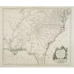
Partie Méridionale de la Louisiane, avec la Floride, la Caroline et la Virginie..
Fine map of southeastern part of the United States after d'Anville's, to whom Santini gives credit in the cartouche.It covers the Atlantic coastline between the Chesapeak...
Place & Date: Venice, 1776 - 1784
Selling price: $1500
Sold in 2008
Parti ved Frederikssted (St. Croix).
Early town-views of the small town of Frederiksted on the island of St. Croix. This view shows much of the harbor and a portion of the town's waterfront. one of a series ...
- $950 / ≈ €889
Place & Date: Copenhagen, Baerentzen / Co, 1856
L'America Meridionale . . .
The second edition of Rossi's map of South America, based upon Sanson's map, but with revised Italian nomenclature. From his 'Mercurio Geografico...'. The engraver was G...
- $900 / ≈ €842
Place & Date: Rome, 1687

Vue de Boston vers le Cale du Port.
A view of the port of Boston, the center of New England shipping in the colonial period. The closing of the port after the Boston Tea Party led to the calling of the Firs...
Place & Date: Augsburg 1762
![[Upper sheet map only] The Provinces New York, and New Jersey with part of Pensilvania and the Province of Quebec.](/uploads/cache/25624-250x250.jpg)
[Upper sheet map only] The Provinces New York, and New Jersey with part of Pensilvania and the Province of Quebec.
Rare separately issued map, unfortunately only the upper part of the map. It is a variant of this important colonial map. The upper sheet showing the upper course of the ...
- $750 / ≈ €702
Place & Date: Frankfurt, 1777
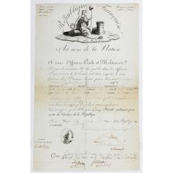
Passeport.
Passport for the United States in the name of Madeleine Lavit Femme Lory, issued by the Commission of Interior Relations and approved by the Committee of Public Safety.Th...
- $750 / ≈ €702
Place & Date: Paris, 1795

Bison Iubatus.
Etching of a bison by Leendert Brasser (1727 - 1793) after a painting of the Dutch artist Gerrit van den Heuvel.An early portrait of a bison, etched by Leendert Brasser (...
Place & Date: Rotterdam, 1766-1793
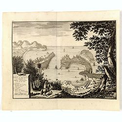
Haven van Aquapulco in ' Coninkryk van Nova Spagnien in de Zuyd Zee.
A finely engraved plan of the harbor, fort and village of Acapulco drawn from a hilltop vantage point looking out to sea. Several galleons are pictured approaching or anc...
- $500 / ≈ €468
Place & Date: Amsterdam, 1726
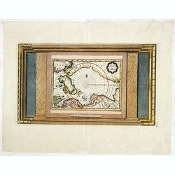
La Terre du Nord.
Map of the Arctic Circle, set within a series of decorative borders, printed from a different copper plate. All counties that lie within or near to the North Pole are sho...
- $750 / ≈ €702
Place & Date: Amsterdam, 1713
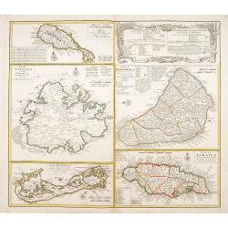
Dominia Anglorum in praecipuis Insulis Americae ut sunt Insula S. Christopheri, Antegoa, Iamaica, Barbados nec non Insula Bermudes vel Sommers . . .
Four maps of the islands of West Indies (St. Christoph "Delineatio Insulae St, Christophori alias I. Kitts", Antigua "Insula Antegoa", Barbados &q...
- $500 / ≈ €468
Place & Date: Nuremberg, 1740
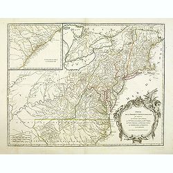
Partie De L'Amerique Septentrionale... Le Cours De L'Ohio, La N.lle Angleterre, a Nlle York, le New Jersey , La Pensyvanie, Le Maryland, Le Virginie, La Carolina...1755
From the Atlas Universel , a detailed map extending the length of the east coast from Penobscot Bay to Cape Fear and, in an inset, from Cape Fear to Fort St.Georges.This ...
- $750 / ≈ €702
Place & Date: Paris, 1768
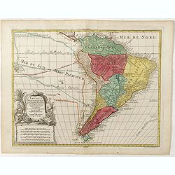
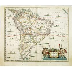
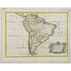
America Meridionalis.
The title cartouche lower left surrounded by native Indians and an Elephant.A rather accurate depiction and descriptions of South America. Brazil is slightly enlarged and...
Place & Date: Augsburg, c. 1760