Browse Listings
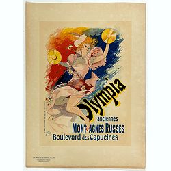
Olympia anciennes montagnes Russes.
Chromo lithographed poster, "Olympia anciennes montagnes Russes.", by CHERET, J. Plate 133, published in Maître 17, on April 1898. The "Les Maîtres de l'...
Date: Paris, Imprimerie Chaix, April 1898
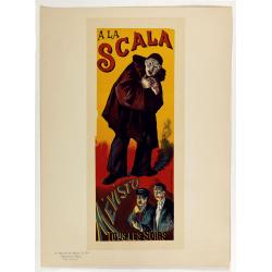
A la Scala, Mevisto.
Chromo lithographed poster, "A la Scala, Mevisto.", by LUCE, M. Plate 139, published in Maître 17, on April 1898. The "Les Maîtres de l'Affiche" con...
Date: Paris, Imprimerie Chaix, April 1898
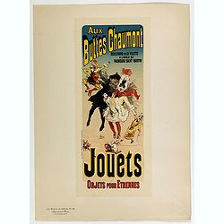
Aux buttes Chaumont.
Chromo lithographed poster, "Aux buttes Chaumont.", by CHERET, J. Plate 141, published in Maître 17, on April 1898. The "Les Maîtres de l'Affiche" c...
Date: Paris, Imprimerie Chaix, April 1898
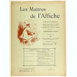
Sommaire du n°32 - Juillet 1898.
Cover binder of Les Maitres de l'Affiche n°32 (3rd year of publication). It used to contains the plates 125, 126, 127 and 128. The "Les Maitres de l'Affiche" c...
Date: Paris, Imprimerie Chaix, July 1898
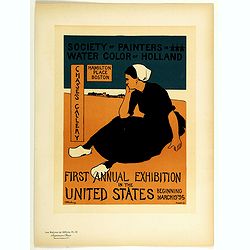
First annual exhibition in the United States . . .
Chromo lithographed poster of Les Maîtres de l'Affiche being plate n°112. The "Les Maîtres de l'Affiche" contained 256 small for lithographic prints of the b...
Date: Paris, Imprimerie Chaix, 1898
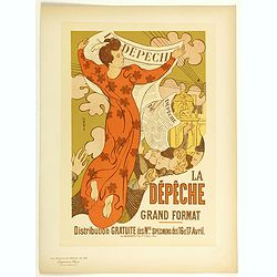
La Dépêche Grand Format.
Chromo lithographed poster of Les Maîtres de l'Affiche being plate n°140. The "Les Maîtres de l'Affiche" contained 256 small for lithographic prints of the b...
Date: Paris, Imprimerie Chaix, 1898
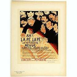
Ah la pé... La pé... La Pépinière Revue . . .
Chromo lithographed poster of Les Maîtres de l'Affiche being plate n°119. The "Les Maîtres de l'Affiche" contained 256 small for lithographic prints of the b...
Date: Paris, Imprimerie Chaix, 1898
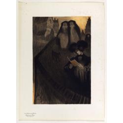
Supplément by De Feure Georges.
Supplement Plate N°8, from Maitres de l'Affiche. Chromo lithographed plate, by De Feure Georges (French, 1868-1943), published in 1898. The "Les Maitres de l'Affich...
Date: Paris, Imprimerie Chaix, April 1898
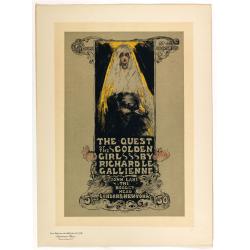
The quest of the golden girl . . .
Chromo lithographed poster, " The quest of the golden girl . . .", after Miss Ethel Reed (American, 1876–d. ca. 1925). Plate 128, published in Maître 32, on ...
Date: Paris, Imprimerie Chaix, April 1898
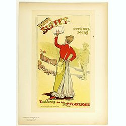
Eugenie Buffet ... La chanteuse populaire.
Chromo lithographed poster of Les Maîtres de l'Affiche being plate n°151. The "Les Maîtres de l'Affiche" contained 256 small for lithographic prints of the b...
Date: Paris, Imprimerie Chaix, 1899
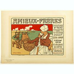
Amieux Freres, sardines et toute conserves.
Chromo lithographed poster of Les Maîtres de l'Affiche, being plate n°183. The "Les Maîtres de l'Affiche" contained 256 small lithographic prints of the best...
Date: Paris, Imprimerie Chaix, 1899

Rowntree's Elect Cocoa.
Chromo lithographed poster of Les Maîtres de l'Affiche, being plate n°168. The "Les Maîtres de l'Affiche" contained 256 small for lithographic prints of the ...
Date: Paris, Imprimerie Chaix, 1899
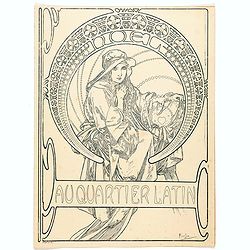
Au quartier Latin.
This image also appears on the Christmas cover of the magazine in 1900. This is the version before the magazine boilerplate was added, but "this black-and-white vers...
Date: Paris, ca. 1899
![[Rain Distribution].](/uploads/cache/46151-250x250.jpg)
[Rain Distribution].
A detailed map from Учебный Географический Атлас published by the very successful St. Petersburg publisher "Cartographic institution A.Ilin...
Date: St. Petersburg, 1899
![[Isothermal Linti].](/uploads/cache/46152-250x250.jpg)
[Isothermal Linti].
A detailed map from Учебный Географический Атлас published by the very successful St. Petersburg publisher "Cartographic institution A.Ilin...
Date: St. Petersburg, 1899
![[Religion Map].](/uploads/cache/46153-250x250.jpg)
[Religion Map].
A detailed map from Учебный Географический Атлас published by the very successful St. Petersburg publisher "Cartographic institution A.Ilin...
Date: St. Petersburg, 1899
![[Europe].](/uploads/cache/46155-250x250.jpg)
[Europe].
A detailed map from Учебный Географический Атлас published by the very successful St. Petersburg publisher "Cartographic institution A.Ilin...
Date: St. Petersburg, 1899
![[Euroidenic Columns all parts of the light].](/uploads/cache/46171-250x250.jpg)
[Euroidenic Columns all parts of the light].
A detailed map from Учебный Географический Атлас published by the very successful St. Petersburg publisher "Cartographic institution A.Ilin...
Date: St. Petersburg, 1899
![[Asia].](/uploads/cache/46172-250x250.jpg)
[Asia].
A detailed map from Учебный Географический Атлас published by the very successful St. Petersburg publisher "Cartographic institution A.Ilin...
Date: St. Petersburg, 1899
![[Africa].](/uploads/cache/46177-250x250.jpg)
[Africa].
A detailed map from Учебный Географический Атлас published by the very successful St. Petersburg publisher "Cartographic institution A.Ilin...
Date: St. Petersburg, 1899
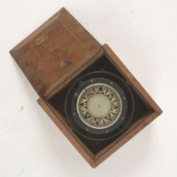
Compass.
A sloop compass in the original wooden box with lit. The compass with floating rose (Cardan system). Slung in gimbals, the east point is decorated and graduated in half ...
Date: c. 1890-1900
![Nankin [Nanjing, Jiangsu]](/uploads/cache/30031-250x250.jpg)
Nankin [Nanjing, Jiangsu]
Very detailed (1:1.000.000) map showing the area north of Nanjing, Jiangsu. The French Service géographique des armées was founded in 1887 and provided the French milit...
Date: Paris, 1900
![[West Central London from Booth's Poverty Map of London]](/uploads/cache/40267-250x250.jpg)
[West Central London from Booth's Poverty Map of London]
A map of West Central London, one section (of twenty) of an extended version of the incredibly influential Poverty Map, originally published in Charles Booth's 'Life and ...
Date: London, 1900
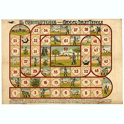
Il cacciatore - Giuoco Dilettevole.
Game of the Goose with 63 numbered boxes, rules in the lower margin. In this game, more players can play and a prismatic die is used with 14 numbers. Whoever goes to the ...
Date: Milan, ca. 1900
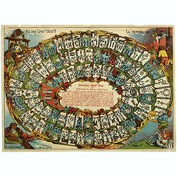
Giuoco dell' Oca. La tentazione
Uncommon Italian Game of the Goose in 90 boxes. The rules of the game are explained as follows: "REGOLA DEL GIUOCO: Questo giuoco è composto di 90 numeri e può ser...
Date: Italy, ca. 1900
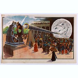
La Lune à un Mètre [Mini poster for Paris Exposition Universelle)
Original lithograph poster for the "Paris Exposition Universelle," held between April and November 1900, which attracted 50 million visitors. In 1899, director...
Date: Paris, c.1900
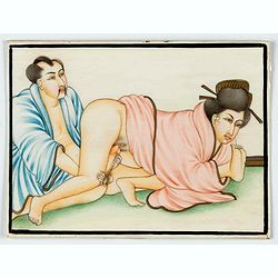
Indian painting on ivory
Fine oriental miniature of an Japanese looking couple. Drawing, brush and gouache on ivory panel, late 19th/ early 20th cent.
Date: India, ca. 1900
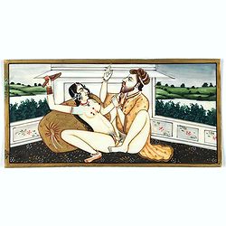
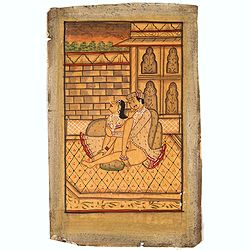
Indian painting on ivory
Fine oriental miniature of a amorous scene of an Indian couple with a landscape in the back. Drawing, brush and gouache on ivory panel, late 19th/ early 20th cent.
Date: Iran, India, ca. 1900
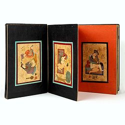
Eight Indian paintings, accordion mounted.
SUPERB SET of eight remarkable free miniatures, presenting couples in natural decorations. The miniatures are painted in Iran or India in late 19th - early 20th century]....
Date: Iran, India, ca. 1900
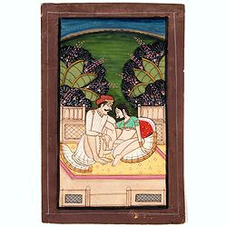
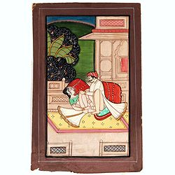
Indian painting on paper.
Fine miniature, presenting a couple in love making position, set on a balcony with in a landscape in the background. The miniature has been painted in India in late 19th ...
Date: India, ca. 1900
Indian painting on paper.
Fine miniature, presenting a couple in love making position, set in an interior. The miniature has been painted in India in late 19th - early 20th century. The miniature ...
Date: India, ca. 1900
Indian erotic painting on paper.
Fine miniature, presenting a couple in a love-making position, set on a balcony within a landscape in the background. The miniature was painted in India in the late 19th ...
Date: India, ca. 1900
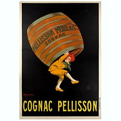
COGNAC PELISSON.
Original advertising poster for the French cognac brand Pellisson, printed by Imprimerie Vercasson, in Paris, designed by Leonetto Cappiello. Leonetto Cappiello, born in ...
Date: Paris, ca. 1900

Anamorphose.
Perspective anamorphosis is an ingenious perspective technique that gives a distorted image of the subject represented in a picture when seen from the usual viewpoint but...
Date: France, ca. 1900
Anamorphose.
Perspective anamorphosis are an ingenious perspective technique that gives a distorted image of the subject represented in a picture when seen from the usual viewpoint bu...
Date: Paris, ca. 1900
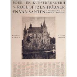
Kasteel Heeswijk.
Very fine etching of the Castle of Heeswijk, by the well-known etcher Ludwig Willem Reymert Wenckebach. He was born in The Hague on 12 January 1860 and died in 1937. The ...
Date: Amsterdam, 1901

COLLECTION OF HONG KONG MAPS, BOOKS & FLYERS. Including CHINA - HONGKONG surveyed by Captn. Sir Edward Belcher, in H.M.S. Sulphur 1841. Corrected to 1901.
A collection of 30 maps, prints, and publications relating to Hong Kong. Including : - BELCHER, E. Sir, An updated version of this most important nautical chart of Hong K...
Date: London, 1841 - 1901
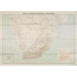
Carte des Missions Catholiques du Sud Africain.
Map of the Catholic Missions in South Africa. Inset map of L'Ile St. Hélène.Published as supplement of the Les Missions Catholiques. To the lower right an inset key to ...
Date: Paris, Monrocq, 1902
![[Soil map] Virginia-Maryland-West Virginia, Leesburg sheet.](/uploads/cache/23257-250x250.jpg)
[Soil map] Virginia-Maryland-West Virginia, Leesburg sheet.
Early color lithographed soil map by Julius Bien & Co. in New York for Department of Agriculture. Legends at side give detail on soil type, etc. They also include int...
Date: New York, 1903

CANTON Kong-Teheou.
Very detailed (1:1.000.000) map centered on Macao and Victoria Island, showing soundings, English, Australian, Danish telegraph lines reaching Hong Kong and extended to M...
Date: Paris, 1898 updated for june 1904
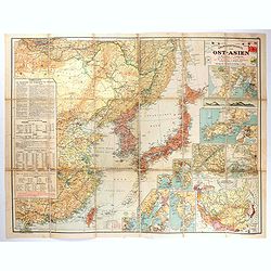
Übersichtskarte von Ost-Asien im Maßstabe 1: 5.000.000 mit 14 Beikarten in großen Maßstäben . . .
A large, uncommon map of East Asia prepared by Karl Peucker, and published by Ataria & Co. Striking and heavily annotated with information on China, Korea, Japan, and...
Date: Vienna, Artaria, 1904

A Humorous Diplomatic Atlas of Europe and Asia. / 滑稽欧亜外交地図 / Kokkei Ō-A Gaikō Chizu.
A wonderful example of the rare 1904 Kisaburo Ohara satirical 'Octopus Map' of Europe being swallowed by an octopus (Russia). Composed at the outbreak of the Russo-Japane...
Date: Tokyo, April, 1904
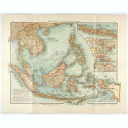
Hinterindien und Malayischer Archipel.
Map of South East Asia with four insets. Shows settlements, roads, railways, telegraph cables, etc. A color key to Dutch, French, British, and Portuguese occupations. Inc...
Date: Leipzig, 1905
![Manila the perl of the Orient. Guide book to the intending visitor [with several photos and 3 plans of Manila]](/uploads/cache/48356-250x250.jpg)
Manila the perl of the Orient. Guide book to the intending visitor [with several photos and 3 plans of Manila]
Charming 1908 Guide book to with several photos and 3 folding plans of Manilla. Published by the "Manila merchants' association", directed by O'Connell, Daniel....
Date: Manilla, 1908
![[Tartary - Russia]](/uploads/cache/44310-250x250.jpg)
[Tartary - Russia]
Postcard size map in Ottoman script showing Siberia prepared by Mehmet EŞREF in a small atlas : عمومولاياةىشهانيىحاوىكوچكاطلاس [Umum-i vil...
Date: Istanbul, 1325 or 1909
![[Australia and New Zealand map with Ottoman script.]](/uploads/cache/44313-250x250.jpg)
[Australia and New Zealand map with Ottoman script.]
Post card size map in Ottoman script showing Australia and New Zealand prepared by Mehmet EŞREF in a small atlas : عمومولاياةىشهانيىحاوىكوچكا�...
Date: Istanbul, 1325 or 1909
![[United States map with Ottoman script.]](/uploads/cache/44314-250x250.jpg)
[United States map with Ottoman script.]
Postcard-size map in Ottoman script showing the United States, prepared by Mehmet EŞREF in a small atlas: عمومولاياةىشهانيىحاوىكوچكاطلاس [...
Date: Istanbul, 1325 or 1909
![[Persia, Afghanistan and Pakistan map with Ottoman script]](/uploads/cache/44316-250x250.jpg)
[Persia, Afghanistan and Pakistan map with Ottoman script]
Postcard size map in Ottoman script showing Persia, Afghanistan and Pakistan prepared by Mehmet EŞREF in a small atlas : عمومولاياةىشهانيىحاوىكو�...
Date: Istanbul, 1325 or 1909
![[Asia map with Ottoman script]](/uploads/cache/44317-250x250.jpg)
[Asia map with Ottoman script]
Postcard size map in Ottoman script showing Asia, prepared by Mehmet EŞREF in a small atlas : عمومولاياةىشهانيىحاوىكوچكاطلاس [Umum-i vilay...
Date: Istanbul, 1325 or 1909
![[Australia, New Zealand and Oceania map with Ottoman script]](/uploads/cache/44319-250x250.jpg)
[Australia, New Zealand and Oceania map with Ottoman script]
Postcard size map in Ottoman script showing Australia, New Zealand and Oceania prepared by Mehmet EŞREF in a small atlas : عمومولاياةىشهانيىحاوىك�...
Date: Istanbul, 1325 or 1909
![[World map in showing currents with Ottoman script]](/uploads/cache/44322-250x250.jpg)
[World map in showing currents with Ottoman script]
Post card size world map in Mercator projection showing the currents in Atlantic and Pacific Oceans in Ottoman script prepared by Mehmet EŞREF in a small atlas : عمو...
Date: Istanbul, 1325 or 1909
![[Set of two maps showing world in Mercator projection, with Ottoman script]](/uploads/cache/44328-250x250.jpg)
[Set of two maps showing world in Mercator projection, with Ottoman script]
Two postcard size maps showing the entire world in Mercator projection. The maps are in Ottoman script prepared by Mehmet EŞREF in a small atlas : عمومولاياة�...
Date: Istanbul, 1325 or 1909
![[ North and South America with telegraph cables, with Ottoman script]](/uploads/cache/44330-250x250.jpg)
[ North and South America with telegraph cables, with Ottoman script]
Postcard size map showing North and South America with telegraph cables. The map is in Ottoman Arabic-script prepared by Mehmet EŞREF in a small atlas : عمومولا�...
Date: Istanbul, 1325 or 1909
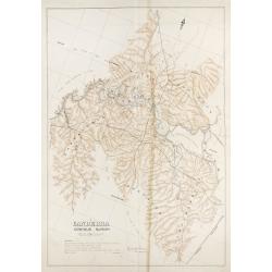
Canberra Contour Survey.
An important large-scale folding map by Charles Scrivener of the present-day city of Canberra, featuring contour lines and elevation data, created as part of the prelimin...
Date: Department of Lands, Sydney N.S.W. July, 1909

Atlas Geographique. (Puzzle).
Three map puzzles, each measuring 25 x 33 cm., housed in the original color printed card case. Geographical jigsaw puzzle set comprising three maps (world, Europe and Fra...
Date: Paris, ca. 1910
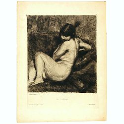
Le Turban.
Etching in brown ink on cream laid paper by Albert Besnard (1849–1934) of a young naked woman with feathered turban. Inscribed below the borderline: (left) “A. Besnar...
Date: Paris, 1910
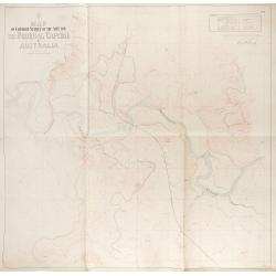
Map of contour survey of the site for the federal capital of Australia.
Map of contour survey of the site for the federal capital of Australia / drawn on stone by Messrs. O. Fischer and A.G. von Stach under direction of E.S. Vautin ; drawn on...
Date: Department of Lands, Sydney, 1910
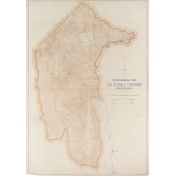
Topographical map of the Federal Territory, Australia.
This map, published by the New South Wales Department of Lands in Sydney in 1910, depicts the Federal Territory—the area designated to house Australia’s future federa...
Date: Sydney, Dept. of Lands, 1910
![[Lot of 2 maps] Map of part of New South Wales Australia shewing position of Commonwealth Territory / Map of New South Wales Australia…](/uploads/cache/49457-250x250.jpg)
[Lot of 2 maps] Map of part of New South Wales Australia shewing position of Commonwealth Territory / Map of New South Wales Australia…
Two maps depicting the region of New South Wales and the area designated as the future Commonwealth Territory (which later became the Australian Capital Territory).The fi...
Date: Department of Lands, Sydney NSW, 1911
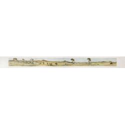
Cycloramic view of Canberra capital site, view looking from Camp Hill / … view looking from Vernon.
Showing an extensive panoramic view of the site of Canberra with various features named. Very large colour photo-mechanical print. Printed by John Sands Ltd [Syd].This 5 ...
Date: Sydney, John Sands, 1911

Nuevo plano de la ciudad de Buenos Aires y parte del partido de avellaneda . . .
A rare detailed city plan of Buenos Aires prepared in 1912 by Ernesto Escalante. The plan depicts the city from the Partido de Avellaneda and the Villa Riachuelo to the R...
Date: Buenos Aires, 1912
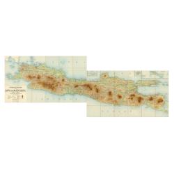
Overzichtskaart van Java en Madoera schaal 1:500.000. Met aanduiding van de politieke indeeling, de organisatie van het bestuur, de bestaande en nog aan te leggen verkeerswegen en van de groote cultuur- en industrieele centra…
If assembled a very large color-printed map (60x 218cm.) of Java and Madoera (Madura Island) on four sheets, each measuring 60 x 54.5 cm, dissected into 12 sections and l...
Date: Atelier Kurkdjian-Soerabaia, 1912
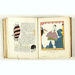
Gazette du Bon Ton Art - Modes Frivolités. (1912/1913 volume)
1912-1913 BON TON - Illustrations by George Lepape, Pierre Brissaud, A. Marty, Bernard B. de Monvel, J.Gosé, Paul Méras.
Date: Paris, 1912-1913

(Postcard of Europe)
During the Great War, when the only means of communicating news to the masses was by newspapers and weekly illustrated magazines, the ‘war’ or 'military' picture post...
Date: Moscow, 1914
Selling price: ????
Please login to see price!
Sold in 2025
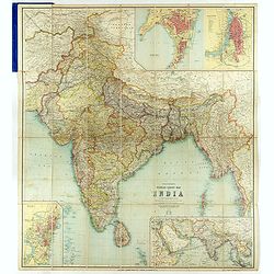
Thacker's Reduced Survey Map of India.
Thacker's reduced Survey Map of India prepared by John Bartholomew and published n Calcutta by Thacker, Spink, & Co. And W. Thacker & Co. in London in 1914.This e...
Date: Calcutta: Thacker, Spink, & Co./ London : W. Thacker and Co., 1914
![[Goose game board] Le 1914 Edition pochette.](/uploads/cache/47214-250x250.jpg)
[Goose game board] Le 1914 Edition pochette.
Goose game in the form of a folding map of north of France and Belgium, with part of England, Germany, Holland and Luxembourg.More about board games [+]
Date: Paris, 1914

Mappa Humoristico da Europa.
A really unusual and lovely map, published in Portugal at the outbreak of The Great War in 1914. This outbreak of war in Europe was the result of a complex sequence of ev...
Date: Lisbon, 1914

Hark ! Hark ! The dogs do bark.
This scarce political caricature map of Europe depicts the continent at the outbreak of World War I, or as it was called at the time, the Great War. Designed by Johnson, ...
Date: London, Johnson Riddle & Co.,1914

Völker Europas wie schön sind eure Geschichter. (World War I post card)
During the Great War, when the only means of communicating news to the masses was by newspapers and weekly illustrated magazines, the ‘war’ or 'military' picture post...
Date: Germany, 1915
![[Cloth Map of Europe]](/uploads/cache/47148-250x250.jpg)
[Cloth Map of Europe]
Anglo-centric cloth map of Europe produced during WWI.Serbia, the spark that lit the conflagration of World War One, isn’t even labeled on this interesting cloth map of...
Date: London, c. 1915
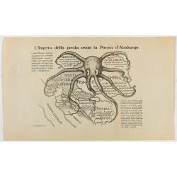
L'Impero della preda ossia la Piovra d'Absburgo.
Austro-Hungarian Octopus zinc lithographed map. A propaganda sheet attacking the Austro-Hungarian Empire, showing it as an octopus with its tentacles wrapped around the v...
Date: La Zincografia, Milan, c. 1915
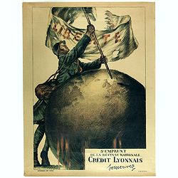
3e emprunt de la Défense nationale Crédit Lyonnais. Souscrivez.
Large color lithographed propaganda World War 1 poster. Designed by the illustrator Faivre Abel (1867-1945). A solder placing the French flag on a globe.English translati...
Date: Paris, 1917
![[Lot of Five Pacific Brand crate labels]](/uploads/cache/45706-250x250.jpg)
[Lot of Five Pacific Brand crate labels]
Five fruit crate label for Pacific Brand, showing a lemon and a map of the Pacific Ocean, centered on Hawaii and including a part of California and Asia, with also Austra...
Date: Santa Barbara, 1917

Mapa Polski i Krajów Osciennych - Wydanie trzecie. Opracowal Stanislaw Max. Wydani M. Arcta.
‘The Birth of Modern Poland on a map’ - an excellent wall map of Poland and surrounding regions, published in Warsaw near the end of World War I, when Poland’s fate...
Date: Warsaw, [H. Sklodowski], 1918

Guaranty Trust Company of New York. Emprunt national 6%.n Souscrivez.
Very decorative propaganda poster with design by Mark All of Paris for "Guaranty Trust Company of New York", a JPMorgan Chase predecessor in order to promote th...
Date: Paris, 1918
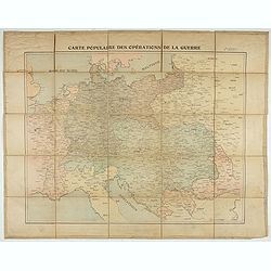
Carte populaire des opérations de la guerre. 2ème édition.
Folding map. War Operations Map showing a part of Europe, published by Epinal.
Date: Paris, ca. 1919

Cigarettes Saphir.
Beautiful late Art Nouveau style poster for the tobacco brand Cigarettes Saphir. Printed by Imprimerie Moullot, in Paris and designed by Stephano. The poster shows a very...
Date: Marseille, ca. 1920
![[6 Post cards of young woman seated on a globe ]](/uploads/cache/41502-250x250.jpg)
[6 Post cards of young woman seated on a globe ]
Complete set of 6 pictorial post cards showing young women seated on a globe. Signed "Morin". Unsent.More aboutcartographical curiosities [+]
Date: Italy, ca. 1920
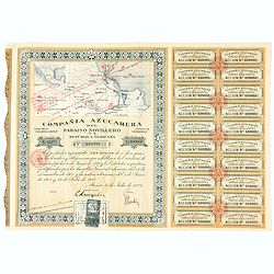
Accion de 10 pesos. No. 110,931 (Share certificate)
Beautifully engraved certificate from the "Compania Azucarera de Paraiso Novillero S.A. Republica Mexicana", share certificate No.110,931 for one share, in a $ ...
Date: Paris, 1924
