Browse Listings in Asia > South East Asia

Tabula nova utriusque Indiae.
This is the fourth and last edition of this map based on Waldseemüller's first "modern" map of Asia. It follows that cartography without change but adds an int...
Date: Vienne, 1541
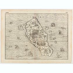
Sumatra.
Gastaldi prepared this map and it was the first separate map of any Southeast Asian island based on actual observation. The general contour of Sumatra is remarkably good ...
Date: Venice, 1556
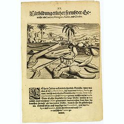
Plants, including the canior, diringuo, pucho and chiabe.
In the Indies there are many delightful plants, which include the ‘costus indicus’ (named by the Malays 'pucho') that has a wonderful aroma. Then there is the ‘cala...
Date: Frankfurt, 1598

India Tercera Nuova Tavola.
The 1598 edition of this early map of South East Asia. Just to the west and south of Malacca one will notice ‘Camatra’ (Sumatra) and Java. China with Canton in the up...
Date: Venice, 1598

Iava Maior.
Very fine miniature map of Java, engraved by Benjamin Wright (1575-1613). This early map contains detailed geography and nomenclature around the northern coastline of the...
Date: Amsterdam, Cornelis Claes, 1606
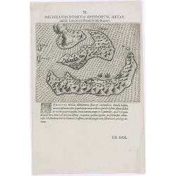
Delineatio Duorum Oppidorum, Ortat.
Early map of the Banda Islands.Theodore de Bry, a German engraver and book dealer, began a compilation of early voyages in 1590 and had published six parts at the time of...
Date: Frankfurt, 1609
Selling price: ????
Please login to see price!
Sold in 2025
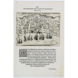
Delineatio Civitatis et Castelli Amboinae.
Early view of Ambon, with 6 Dutch vessels offshore.Theodore de Bry, a German engraver and book dealer, began a compilation of early voyages in 1590 and had published six ...
Date: Frankfurt, 1609
![[Bantam].](/uploads/cache/37970-250x250.jpg)
[Bantam].
Text engravings from "Premier livre de l'histoire de la navigation aux Indes Orientales, par les hollandois, et des choses a eux advenues . . . ", being the cla...
Date: Amsterdam, Cornille Nicolas, 1609

India Orientalis.
Published in Hondius' editions of the Mercator Atlas from 1606 onwards, showing the Indian subcontinent, the Malay Peninsula, Siam and Cambodia, China and the Philippines...
Date: Amsterdam, 1630

Insulae Indiae Orientalis.
Map of South East Asia with good detail on the Philippines from the rare Cloppenburg edition slightly larger format and more scarce edition of the Mercator/Hondius "...
Date: Amsterdam, 1630
India quae Orientalis dicitur, et insulae adiacentes.
Extending from India to Japan and showing parts of Australia. It is indeed one of the first printed maps to show identifiable parts of Australia. It was not revised until...
Date: Amsterdam, 1644

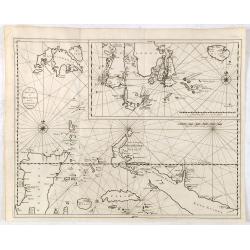
Sumatrae et insularum Locorumque nonnullorum circumiacentium. . .
Fine depicting the Island of Sumatra and the southern coasts of Malaysia from Quedo to Johore.North is orientated to the left of the page.Singapore is probably identifie...
Date: Amsterdam, 1660

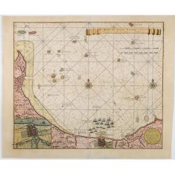
Paskaerte Zynde t'Oosterdeel Van Oost Indien, met alle de Eylanden daer ontrendt geleegen van C. Comorin tota aen Iapan.
An eye-catching chart of Pieter Goos' sea chart of Australia, Southeast Asia, China, Japan, Korea and India. The chart shows the regions from Cape Comorin (Southern India...
Date: Amsterdam, 1669

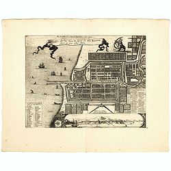
Waere affbeeldinge wegens het casteel ende stadt Batavia.
A good impression of this finely engraved and detailed plan of Batavia, present-day Jakarta, the Dutch center of trading activities in the East Indies. Copied after Cleme...
Date: Amsterdam, 1681

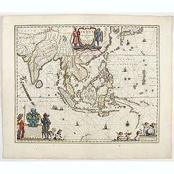
Isole dell'Indie. . .
A beautiful and flamboyantly engraved large-scale map of the East Indies, including the Malay Peninsula, Cambodia, the Philippines and all of Indonesia and the Spice Isla...
Date: Venice, 1696
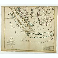
Le Royaume de Siam avec les Royaumes. . .
Influential map of the Malay peninsula, Sumatra, Java and Borneo, centered on Singapore. Mortier incorporated information provided by the French Jesuits and charts the ro...
Date: Amsterdam, 1700
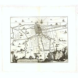
A Mapp of Batavia with all itts Forts.
Wonderful, scarce, and decorative plan of present-day Jakarta, showing the City and its immediate environs, the surrounding rice fields intersected by a network of waterw...
Date: London, Printed for A. and J. Churchill, 1703
![Le Royaume de Siam avec Les Royaumes Qui Luy sont Tributaries & c. / La Royaume de Siam avec les royaumes qui luy sont Tributaires, et les Isles de Sumatra, Andemaon, etc. . . [two sheet map]](/uploads/cache/40698-250x250.jpg)
Le Royaume de Siam avec Les Royaumes Qui Luy sont Tributaries & c. / La Royaume de Siam avec les royaumes qui luy sont Tributaires, et les Isles de Sumatra, Andemaon, etc. . . [two sheet map]
Influential map of Southeast Asia and the East Indies including modern day Thailand, southern Vietnam, Cambodia, Malaysia, Singapore, Borneo, Sumatra and Java. Ottens inc...
Date: Amsterdam, 1710

Vue et Description de Quelques-Uns des Principaux Forts des Hollandois dans les Indes .
Interesting sheet with seven detailed views illustrating the most important Dutch V.O.C. trading outposts and fortified colonial possessions in the East Indies, including...
Date: Amsterdam, 1720

Carte de l'Ile de Java.
An inset plan of Batavia and clearly indicated rice fields, mountains, forests, towns in profile and even elephants suggest the wealth of detail found on this map. Modele...
Date: Amsterdam, 1720

Waere Affbeeldinge Wegens het Casteel ende Stadt BATAVIA Gelegen opt Groot Eylant Java.
A good impression of this finely engraved and detailed plan of Batavia, present-day Jakarta, the Dutch center of trading activities in the East Indies. Copied after Cleme...
Date: Amsterdam, 1721

Nieuwe Caart der Eylanden van Banda.
Decorative map of the Banda Islands. Until the mid-19th century the Banda Islands were the world's only source of the spices nutmeg and mace, produced from the nutmeg tre...
Date: Amsterdam, 1726

Nieuwe Kaart van het Eyland Sumatra..
Fine chart depicting the Island of Sumatra and the southern coasts of Malaysia from Quedo to Johore. North is orientated to the left of the page. Singapore is probably id...
Date: Amsterdam, 1726
De Landvoogdy der Moluccos met de Aangrenzende Eylanden . . .
Two charts on one sheet depicting the Moluccas islands. Little interior detail is given but the coastlines, settlements and principal coastal features are identified. To ...
Date: Amsterdam, 1726
De Reede en stadt Batavia is geleegen aan de Noord Kust…
A chart of the bay of Batavia with in lower left corner a plan of Batavia (120x147mm). This very rare and influential chart gives a fine representation of Batavia, now kn...
Date: Amsterdam, 1728
Plan de la Ville et du Chateau de Batavia en l'Isle de Iava / Ware affbeeldinge wegens het Casteel ende Stadt Batavia gelegen opt groot Eylant Java.
Detailed East oriented plan of Jakarta former Batavia on Java / Indonesia. With bird eye view from sea side, various ships and a lion. Two inset keys with detailed descri...
Date: Leiden, 1730

Insularum Moluccarum Nova description.
Exquisite map of the famous Spice Islands based. This map was the first large-scale map of the region and depicts the islands which provided first the Portuguese and then...
Date: Amsterdam, 1730

Der Hollaendisch-Ostindianischen Compagnie Weltberühmte Haupt - Handels und Niederlags stadt BATAVIA..
Very fine decorative plan of Batavia showing the City and its immediate environs, the surrounding rice fields intersected by a network of waterways, canals and outlying f...
Date: Nuremberg, 1733

Allerneuester geographisch- und topographischer Schau-Platz von Africa und Ost-Indien. . .
An early issue of this important book by Johann Wolfgang Heydt's describing the Dutch factories, settlements and stations at the hands of the Dutch East India Company in ...
Date: Wilhermsdorf, Tetscher u. Nürnberg, Homanns Erben, 1744

Carte de L'Isle de Sumatra Dressee sur les Journaux des Navigateurs . . .
Detailed map of Sumatra and Malacca, centered on Singapore and including the southern portion of the Malaysian peninsula. With "Detroit de Sincapour" and severa...
Date: Paris, ca. 1750

Vue de L'Hotel de Batavie. . .
A so-called optical print of Fatahillah Square in Jakarta, Indonesia, prepared for use in a light-box or an amusing light-show. This richly hand colored print is much per...
Date: Augsburg, 1750

Belgium Foederatum auctius et emendatius edit..
Map of the northern part of the Netherlands. With a decorative title cartouche, with an inset map of South East Asia.
Date: Augsburg 1760

The Fan palm, in the island of Cracatoa.
The Fan palm, on the island of Krakatoa (Indonesian name: Krakatau), in the Sunda Strait, taken from "Views in the South Seas" being a very important and early ...
Date: London, Boydell and Co., 1808
![View in the island of Cracatoa. [Rakata in the Sunda Strait]](/uploads/cache/30051-250x250.jpg)
View in the island of Cracatoa. [Rakata in the Sunda Strait]
Early view of the volcano Krakatoa (Indonesian name: Krakatau), on the Indonesian island of Rakata in the Sunda Strait, taken from "Views in the South Seas" bei...
Date: London, Boydell and Co., 1808
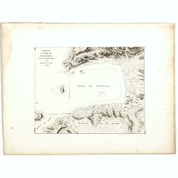
Esquisse de la Baie de Coupang (cote S.O. Ile de Timor) par M. M. Peron et Lesueur, an 1803.
Map of Kupang Bay on the Indonesian Island Timor, prepared by Louis Freycinet during his voyage under Captain Thomas Baudin in 1800-1803. Plate no. 14 from the atlas part...
Date: Paris, Langois, 1811
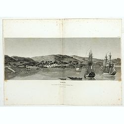
Timor. Vue de la rade, de la ville et du fort de Coupang, dans l'île de Timor.
Nice double page view of the town Kupang, formerly known as Koepang. In the center is the Dutch V.O.C. fort. From Voyage de découvertes aux terres Australes by François...
Date: Paris, 1807-1816
![Timor. Rhinolophe Cruménifére. [plate XXXV]](/uploads/cache/46357-250x250.jpg)
Timor. Rhinolophe Cruménifére. [plate XXXV]
Plate illustrating Horseshoe bats from Timor Island, by Lesueur, from Voyage de découvertes aux terres Australes by François Péron, 1824.The French expedition under Ni...
Date: Paris, 1824
![Timor. Canda Jeune fille Malaise. [plate XXVI]](/uploads/cache/46348-250x250.jpg)
Timor. Canda Jeune fille Malaise. [plate XXVI]
A portrait of a female Canda by Lesueur, from Voyage de découvertes aux terres Australes by François Péron, 1824.The French expedition under Nicolas Baudin, was commis...
Date: Paris, 1824
![Timor. Naba-Leba Roi de L'Ile Solor. [plate XXV]](/uploads/cache/46347-250x250.jpg)
Timor. Naba-Leba Roi de L'Ile Solor. [plate XXV]
A portrait of a male Naba-Leba by Lesueur, from Voyage de découvertes aux terres Australes by François Péron, 1824.The French expedition under Nicolas Baudin, was comm...
Date: Paris, 1824

Kaart van de Gaspar Straaten volgens opnemingen van J.Stolze, D.Ross, enz.
Very large and rare chart centered on the strait between Bangka's southeastern seacoast and Belitung's western shores.Short front views of the coastal relief are shown in...
Date: Amsterdam 1843

Straat Riouw onder opzicht van de commissie tot verbetering der Indische Zeekaarten..
Very large and rare so-called Blue Back centered on the strait passing between the Riau Islands. It contains an inset map with enlarged details of Riouw Harbor on Bintang...
Date: Amsterdam 1843

Kaart van een gedeelte van de Noord Kust van Java en Straat Sunda van Tanjong Kaik tot den vierden hoek bij Anjer..
Very large and rare chart depicting Java's northern seacoast.Coastal profiles are present at the bottom of the map.The chart is prepared by B.H.Staring, J.A.G.Rietveld an...
Date: Amsterdam 1843-1844

Straat Sunda en Westkust van Java.
Very large and rare chart depicting Java's western seacoast close to the Sunda Strait.Showing part of Sumatra on top and the West Java tip, today hosting the Ujung Kulon ...
Date: Amsterdam (1841)1846

Kaart van de Reede van Batavia met de verschillende vaarwaters naar dezelve trigometrisch opgenomen op last van deb schout bijnacht E.Lucas.
Very large and rare so-called blue-black chart centered on Jakarta's harbor.The chart is prepared by B.G.Escher, I.A.C. Eschauzier, B.H.Staring and E.H.Boom during an exp...
Date: Amsterdam (1841) 1847

Kaart der Moluksche eilanden en vaarwateren … F.A.A. Gregory Luitenant ter zee …
Huge sailing chart centered on the Moluccas Islands. Published by Widow Gerard Hulst van Keulen.The publishing house van Keulen, were the most prominent chart makers at ...
Date: Amsterdam, 1847

Kaart van Het Noordelijk Gedeelte Van Het Eiland Borneo.
A very detailed map of Northern Borneo including Brunei, taken from the "Atlas der Nederlandsche bezittingen in Oost-Indië", which was published by Departement...
Date: The Hague, 1883-1885
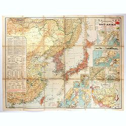
Übersichtskarte von Ost-Asien im Maßstabe 1: 5.000.000 mit 14 Beikarten in großen Maßstäben . . .
A large, uncommon map of East Asia prepared by Karl Peucker, and published by Ataria & Co. Striking and heavily annotated with information on China, Korea, Japan, and...
Date: Vienna, Artaria, 1904
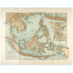
Hinterindien und Malayischer Archipel.
Map of South East Asia with four insets. Shows settlements, roads, railways, telegraph cables, etc. A color key to Dutch, French, British, and Portuguese occupations. Inc...
Date: Leipzig, 1905
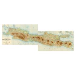
Overzichtskaart van Java en Madoera schaal 1:500.000. Met aanduiding van de politieke indeeling, de organisatie van het bestuur, de bestaande en nog aan te leggen verkeerswegen en van de groote cultuur- en industrieele centra…
If assembled a very large color-printed map (60x 218cm.) of Java and Madoera (Madura Island) on four sheets, each measuring 60 x 54.5 cm, dissected into 12 sections and l...
Date: Atelier Kurkdjian-Soerabaia, 1912

Ce que les Anglo-Saxons ont perdu en Extrême-Orient.
Illustrated Vichy propaganda War & Propaganda poster showing a map of South East Asia, with Indonesia, Philippines, Thailand, etc., among photos and explanations abou...
Date: Paris, 1943

Indie moet vrij vecht ervoor.
War propaganda poster by Patrick (Pat) Cokayne Keely, distributed in the liberated South of the Netherlands, this poster concerned the Japanese occupation of Indonesia an...
Date: London, J.Haworth / Brother Ltd, 1944

Du sang à l'aube.
Original lithographed poster for the Spanish movie "Blood at dawn" (1948) directed by Rafael Gil, based on the novel by Blasco Ibanez. Poster designed by Duccio...
Date: Paris, 1948

Indonesia.
Original vintage travel advertising issued by the Indonesian Council for Tourism featuring a colorful pictorial map marking the islands and oceans with images of local pe...
Date: Jakarta, ca. 1955
