Please login to see price!.
Subscribe to be notified if similar examples become available.
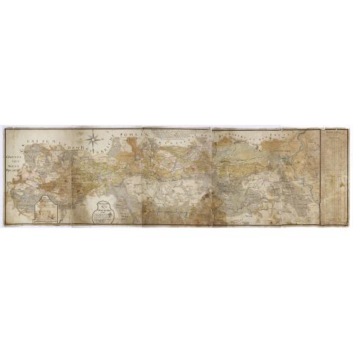
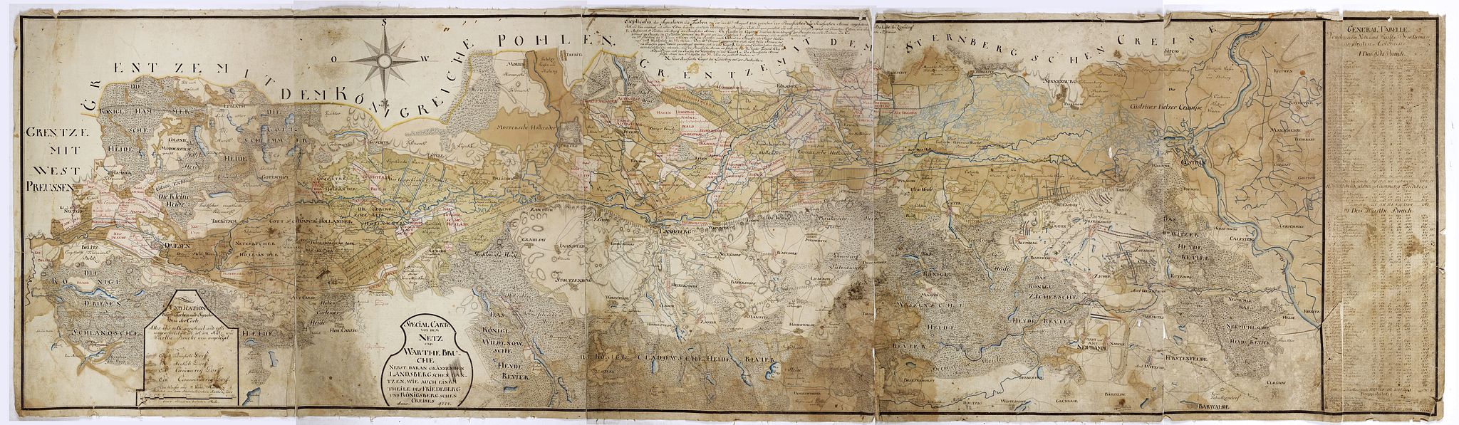
Special Carte von dem Netz und Warthe Bruche nebst daran gränzenden Landsbergschen gantzen, wie auch einem theile des Friedeberg und Königsbergschen Creises. |
||||||||||||||||||||
|
||||||||||||||||||||
|
|
||||||||||||||||||||
|
|
Collection - Save and collect this or any of your favorite items in one place.
If you want to save the items permanently, please sign in or create account first. |
|||||||||||||||||||
Description
A MORE THAN 2 METERS MANUSCRIPT MAP OF WEST-CENTRAL POLAND
In top a large compass rose and south is interestingly oriented to the top. The river Oder is to the utmost right of the map. Showing in great detail part of the rivers Warthe (or Warta) and its tributary the Netze (or Notec), in the Greater Poland Voivodeship, also known as Wielkopolska Voivodeship, in west-central Poland.
Including the town of Zorndorf, (now Sarbinowo) well-known for The Battle of Zorndorf, which was the bloodiest battle of the Seven Years War. The map has a lettered key (A – N) showing positions of the Prussian and Russian positions. Also showing Landberg (now Gorzów Wielkopolski, the second largest city in the Lubusz Voivodeship). The map gives excellent detail of the two rivers and their numerous tributaries and arms, canals, lakes, forests, roads, villages and towns.
The map is dated 1774 but not signed. The basis of the map shows the situation for the year 1758 with the troop positions of the Battle of Zorndorf drawn in. A key explains that the town names, roads and land possessions in Red are the newly added places. “Explication Derer Farben und Signaturen in der Carte. Alles was roth gezeichnet und roth eingeschrieben ist, ist im Netz und Warthe – Bruche neu angelegt…”.
and in red the newly added villages, roads and land possessions are updated for the year 1774 and marked in red ink.
The map shows the positions of the Russian and Prussian divisions during the Battle of Zorndorf (now Sarbinowo, Poland) which took place on 25 August 1758 . It was the bloodiest battle of the Seven Years’ War, fought between the forces of the Russians troops under the command of Count William Fermor and a Prussian army under King Frederick the Great. The battle was tactically inconclusive, with both armies holding the ground and claiming victory.
Background of Battle of Zorndorf
After the victory at Kolín, having pushed the Prussians out of Bohemia in the summer of 1757, and the cleverly waged campaign in the autumn that saw Lieutenant-General the Duke of Bevern's Prussians defeated at the Battle of Breslau (22 November 1757), Empress Maria Theresa of Austria believed her fortunes were taking a turn for the better however, the situation soon changed when Frederick defeated, first. the French at Rossbach and, then, the Austrians at Leuthen.
In August 1758, Austria's ally Russia invaded East Prussia with 43,000 troops under William Fermor advanced within 100 km (62 mi) of Berlin, and were poised to join the Austrians under Field Marshal Daun. The king, Frederick II of Prussia, understood that the joining of his enemies would spell the fall of Berlin and, deciding to forestall their plans, moved to the Russian rear. Fermor, who was then besieging Küstrin, learned about this maneuver from a Cossack sortie. He lifted the siege and occupied a position at Zorndorf, 10 km (6 mi) northeast of Küstrin.
Battle
On August 25 Frederick's infantry attacked a Russian "Observation Corps", which consisted of young conscripts only. The Russians managed to hold their own until the famed cavalry of Friedrich Wilhelm von Seydlitz struck against them. The Russian cavalry clashed with the Prussians, but was routed and had to flee towards the lines of the Russian infantrymen who, confused by clouds of dust and gun smoke, mistook them for the Prussians and opened artillery fire.
In the meantime, Frederick's infantry fell upon the left wing of the Russian army. Frederick intended to repeat the oblique order assault that had granted him victory at the Battle of Leuthen, yet as the Russian lines were unable to retreat due to the swamps in their rear,[4] and the left flank of Frederick's army was likewise unable to enclose the Russian lines because of the unfavorable terrain and successful Russian resistance,[8] the battle took the course of an extremely bloody, frontal clash of the adversaries' armies within a narrow battlefield setting.
During the ensuing battle, both sides quickly ran out of gunpowder and engaged in hand-to-hand fighting. When some of the Prussian battalions showed signs of tiring, Frederick himself led them in an attack. The battle was described by contemporaries as the bloodiest in the 18th century. One Prussian officer reported that "bodies of Russians covered the field row by row they kissed their cannons while their bodies were cut to pieces by our sabers, but still they would not retreat".
After the battle, Frederick famously declared that "it's easier to kill the Russians than to win over them".
Battle of Zorndorf, by Alexander Kotzebue.
Aftermath
The Prussians lost 12,800 men, the Russians lost 18,000 in total. That the Russians took such heavy casualties and did not pull back, left an imprint on the Prussian soldiers and Frederick himself. Before the battle he regarded the Russian army as weaker than his own, but in this battle the Russians proved themselves tough opponents and Frederick was frustrated by their tenacity.
The battle appeared inconclusive, since neither side was defeated and driven from the battlefield. After the fighting, Frederick withdrew his cavalry to stop the ongoing skirmish with the Cossacks, thereby allowing the Russian army to re-establish contact with its supply wagons.
Considering himself the victor, Fermor sent a letter to Saint Petersburg, assembled his troops into two columns and marched towards Landsberg to link up with the forces of Count Pyotr Rumyantsev.
In top a large compass rose and south is interestingly oriented to the top. The river Oder is to the utmost right of the map. Showing in great detail part of the rivers Warthe (or Warta) and its tributary the Netze (or Notec), in the Greater Poland Voivodeship, also known as Wielkopolska Voivodeship, in west-central Poland.
Including the town of Zorndorf, (now Sarbinowo) well-known for The Battle of Zorndorf, which was the bloodiest battle of the Seven Years War. The map has a lettered key (A – N) showing positions of the Prussian and Russian positions. Also showing Landberg (now Gorzów Wielkopolski, the second largest city in the Lubusz Voivodeship).
The map gives excellent detail of the two rivers and their numerous tributaries and arms, canals, lakes, forests, roads, villages and towns.
The map is dated 1774 but not signed. The basis of the map shows the situation for the year 1758 with the troop positions of the Battle of Zorndorf drawn in. A key explains that the town names, roads and land possessions in Red are the newly added places. “Explication Derer Farben und Signaturen in der Carte. Alles was roth gezeichnet und roth eingeschrieben ist, ist im Netz und Warthe – Bruche neu angelegt…”.
and in red the newly added villages, roads and land possessions are updated for the year 1774 and marked in red ink.
The map shows the positions of the Russian and Prussian divisions during the Battle of Zorndorf (now Sarbinowo, Poland) which took place on 25 August 1758 . It was the bloodiest battle of the Seven Years’ War, fought between the forces of the Russians troops under the command of Count William Fermor and a Prussian army under King Frederick the Great. The battle was tactically inconclusive, with both armies holding the ground and claiming victory.
Background of Battle of Zorndorf
After the victory at Kolín, having pushed the Prussians out of Bohemia in the summer of 1757, and the cleverly waged campaign in the autumn that saw Lieutenant-General the Duke of Bevern's Prussians defeated at the Battle of Breslau (22 November 1757), Empress Maria Theresa of Austria believed her fortunes were taking a turn for the better however, the situation soon changed when Frederick defeated, first. the French at Rossbach and, then, the Austrians at Leuthen.
In August 1758, Austria's ally Russia invaded East Prussia with 43,000 troops under William Fermor advanced within 100 km (62 mi) of Berlin, and were poised to join the Austrians under Field Marshal Daun. The king, Frederick II of Prussia, understood that the joining of his enemies would spell the fall of Berlin and, deciding to forestall their plans, moved to the Russian rear. Fermor, who was then besieging Küstrin, learned about this maneuver from a Cossack sortie. He lifted the siege and occupied a position at Zorndorf, 10 km (6 mi) northeast of Küstrin.
Battle
On August 25 Frederick's infantry attacked a Russian "Observation Corps", which consisted of young conscripts only. The Russians managed to hold their own until the famed cavalry of Friedrich Wilhelm von Seydlitz struck against them. The Russian cavalry clashed with the Prussians, but was routed and had to flee towards the lines of the Russian infantrymen who, confused by clouds of dust and gun smoke, mistook them for the Prussians and opened artillery fire.
In the meantime, Frederick's infantry fell upon the left wing of the Russian army. Frederick intended to repeat the oblique order assault that had granted him victory at the Battle of Leuthen, yet as the Russian lines were unable to retreat due to the swamps in their rear,[4] and the left flank of Frederick's army was likewise unable to enclose the Russian lines because of the unfavorable terrain and successful Russian resistance,[8] the battle took the course of an extremely bloody, frontal clash of the adversaries' armies within a narrow battlefield setting.
During the ensuing battle, both sides quickly ran out of gunpowder and engaged in hand-to-hand fighting. When some of the Prussian battalions showed signs of tiring, Frederick himself led them in an attack. The battle was described by contemporaries as the bloodiest in the 18th century. One Prussian officer reported that "bodies of Russians covered the field row by row they kissed their cannons while their bodies were cut to pieces by our sabers, but still they would not retreat".
After the battle, Frederick famously declared that "it's easier to kill the Russians than to win over them".
Battle of Zorndorf, by Alexander Kotzebue.
Aftermath
The Prussians lost 12,800 men, the Russians lost 18,000 in total. That the Russians took such heavy casualties and did not pull back, left an imprint on the Prussian soldiers and Frederick himself. Before the battle he regarded the Russian army as weaker than his own, but in this battle the Russians proved themselves tough opponents and Frederick was frustrated by their tenacity.
The battle appeared inconclusive, since neither side was defeated and driven from the battlefield. After the fighting, Frederick withdrew his cavalry to stop the ongoing skirmish with the Cossacks, thereby allowing the Russian army to re-establish contact with its supply wagons.
Considering himself the victor, Fermor sent a letter to Saint Petersburg, assembled his troops into two columns and marched towards Landsberg to link up with the forces of Count Pyotr Rumyantsev.
FAQ - Guarantee - Shipping
Buying in the BuyNow Gallery
This item is available for immediate purchase when a "Add to Cart" or "Inquire Now" button is shown.
Items are sold in the EU margin scheme
Payments are accepted in Euros or US Dollars.
Authenticity Guarantee
 We provide professional descriptions, condition report (based on 45 years experience in the map business)
Paulus Swaen warrants the authenticity of our items and a certificate of authenticity is provided for each acquired lot.
Condition and Coloring
We indicate the condition of each item and use our unnique HiBCoR grading system in which four key items determine a map's value: Historical Importance, Beauty, Condition/Coloring and Rarity.
Color Key
We offer many maps in their original black and white condition. We do not systematically color-up maps to make them more sellable to the general public or buyer.
Copper engraved or wood block maps are always hand colored. Maps were initially colored for aesthetic reasons and to improve readability. Nowadays, it is becoming a challenge to find maps in their original colors and are therefor more valuable.
We use the following color keys in our catalog:
Original colors; mean that the colors have been applied around the time the map was issued.
Original o/l colors; means the map has only the borders colored at the time of publication.
Colored; If the colors are applied recently or at the end of the 20th century.
Read more about coloring of maps [+]
Shipping fee
A flat shipping fee of $ 30 is added to each shipment by DHL within Europe and North America. This covers : International Priority shipping, Packing and Insurance (up to the invoice amount).
Shipments to Asia are $ 40 and rest of the world $50
We charge only one shipping fee when you have been successful on multiple items or when you want to combine gallery and auction purchases.
Read more about invoicing and shipping
FAQ
Please have a look for more information about buying in the BuyNow gallery
Many answers are likely to find in the general help section.
Collection
![]()
With Collection you can collect all your favorite items in one place. It is free, and anyone can create his or her Virtual map collection.
Unless you are logged in, the item is only saved for this session. You have to be registed and logged-in if you want to save this item permanently to your Virtual Collection.
Read More[+]
Register here, it is free and you do not need a credit card.
Add this item to
Virtual Collection
or click the following link to see my Collection.
| Digital Image Download | |
|
Paulus Swaen maintains an archive of most of our high-resolution rare maps, prints, posters and medieval manuscript scans. We make them freely available for download and study. Read more about free image download |
Click the image for a free small image download. |
In accordance with the EU Consumer Rights Directive and habitually reside in the European Union you have the right to cancel the contract for the purchase of a lot, without giving any reason.
The cancellation period will expire 14 calendar days from the day after the date on which you or a third party (other than the carrier and indicated by you) acquires, physical possession of the lot. To exercise the right to cancel you must inform Paulus Swaen Inc, of your decision to cancel this contract by a clear statement (e.g. a letter sent by post, or e-mail (amsterdam@swaen.com).
To meet the cancellation deadline, it is sufficient for you to send your communication concerning your exercise of the right to cancel before the cancellation period has expired.
