Browse Listings
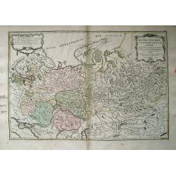
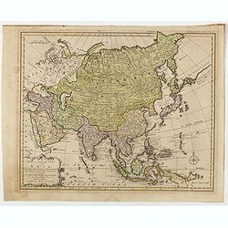
Russie d'Europe avec la Partie la plus Peuplee de celle d'Asie...
Interesting map covering from Poland and the Baltics, eastward as far as Siberia, with Jenisseisk/Krasnojarsk. Extends to the Black Sea and includes Nouvelle Zembla. Very...
Date: Paris, c1775
Selling price: ????
Please login to see price!
Sold in 2013
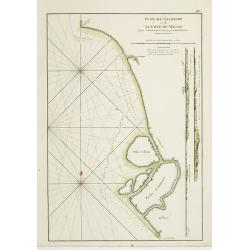
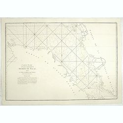
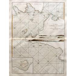
Plan de Salangor et de la Cote de Malaye depuis la Pointe de Caran jusqu'au Mont Parcelar.
Important early French of Salangor and Coast of Malaye, with two profile views over the coast near Selangor. From the second edition.Latitude and longitude scales, compa...
Date: Paris, Brest, chez Demonville, 1775
Selling price: ????
Please login to see price!
Sold in 2013
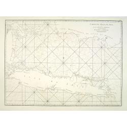
Carte de l'Isle de Java avec les Isles de Banca, de Biliton, et une partie de cellesd de Sumatra et de Bornéo.
French of the Island of Java, Banca, Billiton, and part of Sumatra and Borneo.Latitude and longitude scales, compass rose and system of rhumb lines, soundings near coast...
Date: Paris, Brest, chez Demonville, 1775
Selling price: ????
Please login to see price!
Sold in 2013
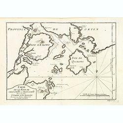
Carte de la Baye de Chin-Chew ou Chang-Chew avec les Isles d'Emowi et de Quemowi ...
A small but very early and interesting map of the coastline from Pu-tay Point, down to the Chin Chew river, with Ko-long-fu, Lakkateyn, Tano-fita, Roo Point, Womends Isle...
Date: Paris, 1738-1775
Selling price: ????
Please login to see price!
Sold in 2013
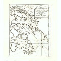
Carte de l'Entrée de la riviere de Canton Dressee sur les Observations les plus recentes.
A small but very early and interesting map of the mouth of the Canton River with the island of Macao and the future site of Hong Kong (Sinn-gan-hien). The fortified city ...
Date: Paris, 1738-1775
Selling price: ????
Please login to see price!
Sold in 2022
A Mar of part of Borneo and the Sooloo Archipelago: Laid down chiefly from observations made in 1761, 2,3, and 4.
Most important milestone based upon the surveys made from navigational surveys in 1761-64 by Alexander Dalrymple (1737-1808]. He was the first hydrographer of the Britis...
Date: Paris, ca 1775
Selling price: ????
Please login to see price!
Sold in 2014
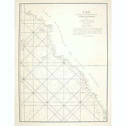
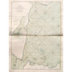
Carte de la Côte occidentale de l\'Isle de Sumatra. . .
French of the lower west coast of Sumatra. Latitude and longitude scales, compass rose and system of rhumb lines, soundings near coast and in bay areas.D' Après de Mann...
Date: Paris, Brest, chez Demonville, 1775
Selling price: ????
Please login to see price!
Sold in 2014
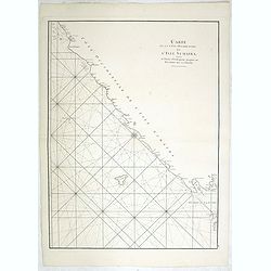
Carte de la côte occidentale de l\'isle Sumatra depuis la ligne équinoctiale jusqu\'au détroit de la Sonde
French of the east coast of Sumatra.Latitude and longitude scales, compass rose and system of rhumb lines, soundings near coast and in bay areas.D' Après de Mannevillet...
Date: Paris, Brest, chez Demonville, 1775
Selling price: ????
Please login to see price!
Sold in 2014
Carte Plate de la partie Septentrionale du Detroit de Malac, depuis la Rade d\'Achem Jusqu\'a Malac.
French of the Malacca Strait north of Malacca, on page (39) from Le Neptune Orientale, 2nd edition. Latitude and longitude scales, compass rose and system of rhumb lines...
Date: Paris, Brest, chez Demonville, 1775
Selling price: ????
Please login to see price!
Sold in 2014
![[Set of six costume plates of the Ottoman Empire.]](/uploads/cache/93775-250x250.jpg)
[Set of six costume plates of the Ottoman Empire.]
Fine and decorative hand colored engraved prints, from "Recueil des differents costumes des principaux Officiers et Magistrats de la Porte...".A complete set of...
Date: Paris, 1775
Selling price: ????
Please login to see price!
Sold in 2021
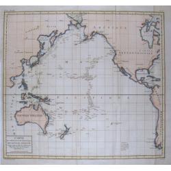
Carte des déclinaisons et inclinaisons de l'aiguille aimantée...1775.
Scarce sea-chart of the Pacific Ocean illustrating the magnetic variations. With large parts of America, East Asia, and including Australia and New Zealand. Australia is ...
Date: Paris, c1775
Selling price: ????
Please login to see price!
Sold in 2015
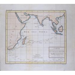
Carte des déclinaisons et inclinaisons de l'aiguille aimantée...1775.
Unusual smaller size edition of this sea-chart of the Indian Ocean illustrating the magnetic variations. With large parts of Africa, Arabia, and South East Asia. Rare ...
Date: Paris, c1775
Selling price: ????
Please login to see price!
Sold in 2020
Carte de l'inde en deça du gange comprenant l'Indoustan.
An interesting map of Hindustan and the River Ganges .Prepared by Jacques Nicolas Bellin after Dutch sources and included in Prévost d' Exile's "Histoire des Voyage...
Date: Paris, 1738-1775
Selling price: ????
Please login to see price!
Sold in 2020
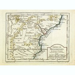
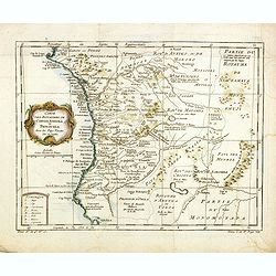
Empire du Monomotapa et Etats Voisins. . .
A small interesting map of the Kingdom of Monomotapa roughly in today's Mozambique. Based on Delisle, it includes the Zambeze River.Prepared by Jacques Nicolas Bellin and...
Date: Paris, 1738-1775
Selling price: ????
Please login to see price!
Sold in 2014
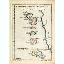
Carte Particuliere Des Isles Moluques. . .
A small interesting map of the islands of Herij, Pottebackers, Ternate, Tidor, Timor, Machian and Bachian. Today the Moluccas are part of Indonesia.Prepared by Jacques Ni...
Date: Paris, 1738-1775
Selling price: ????
Please login to see price!
Sold in 2014
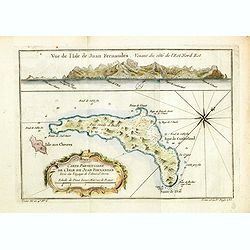
Carte particulière de l'Isle de Juan Fernandes tirée du Voyage de l'Amiral Anson.
An interesting map of Robinson Crusoe Island, off the coast of Chile, from the atlas of Prevost d'Exiles' travel book, "Voyage de l'Amiral Anson". Detailed map ...
Date: Paris, 1738-1775
Selling price: ????
Please login to see price!
Sold in 2014
Carte de l'Inde en deça du Gange comprenant l'Indoustan.
An interesting map of Hindustan and the River Ganges.Prepared by Jacques Nicolas Bellin after Dutch sources and included in Prévost d' Exile's "Histoire des Voyages...
Date: Paris, 1738-1775
Selling price: ????
Please login to see price!
Sold in 2020
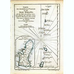
Carte de l'Archipel de St Lazare ou les Isles Marianes.
An interesting map the archipelago of St Lazare or Marianne's islands, on Alsonso P. Lopez maps and the Spanish Jesuits memory .Prepared by Jacques Nicolas Bellin after D...
Date: Paris, 1738-1775
Selling price: ????
Please login to see price!
Sold in 2017
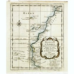
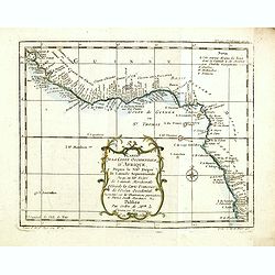
Coste occidentale d'Afrique depuis le Détroit de Gibraltar.
An interesting map of the North-West coast of Africa, from the Straits of Gibraltar to the Gambia River and Cachau. The detailed map includes the Canary Islands, Madeira,...
Date: Paris, 1738-1775
Selling price: ????
Please login to see price!
Sold in 2016
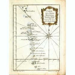
Carte des Isles Maldives, pour servir à l'Histoire Générale des Voyages.
An interesting map of all the islands of the Maldives.Prepared by Jacques Nicolas Bellin after Dutch sources and included in Prévost d' Exile's "Histoire des Voyage...
Date: Paris, 1738-1775
Selling price: ????
Please login to see price!
Sold in 2014
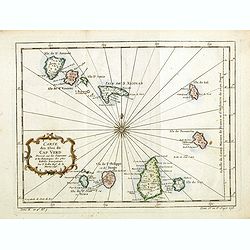
Carte des Isles du Cap Verd.
An interesting map of the islands of the Cap Verd.Prepared by Jacques Nicolas Bellin after Dutch sources and included in Prévost d' Exile's "Histoire des Voyages&qu...
Date: Paris, 1738-1775
Selling price: ????
Please login to see price!
Sold in 2016
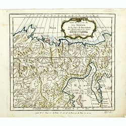
Suite de la carte de La Sibérie et le pays de kamtfchatka.
An interesting map of Siberia, with a view on Ochozk Sea.Prepared by Jacques Nicolas Bellin after Dutch sources and included in Prévost d' Exile's "Histoire des Voy...
Date: Paris, 1738-1775
Selling price: ????
Please login to see price!
Sold in 2014
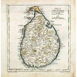
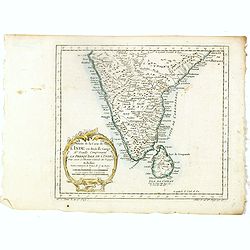
Carte de l'Isle de Ceylan, pour servir à l'Histoire Générale des Voyages.
An interesting map of the island of Ceylon which is now known as Sri Lanka, includes rivers mountains forests and symbols for small towns and cities .Prepared by Jacques ...
Date: Paris, 1738-1775
Selling price: ????
Please login to see price!
Sold in 2014
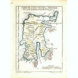
Carte de l'Isle Célèbres ou Macassar, pour servir à l'Histoire Générale des Voyages.
An interesting map of Célèbres island or Macassar, in Indonesia .Prepared by Jacques Nicolas Bellin after Dutch sources and included in Prévost d' Exile's "Histoi...
Date: Paris, 1738-1775
Selling price: ????
Please login to see price!
Sold in 2016
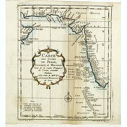
Carte des Costes de Perse, Gusarat, et Malabar.
An interesting map of the coasts of the Persian Gulf, Iran, Pakistan and Western India including the Maldives Islands .Prepared by Jacques Nicolas Bellin after Dutch sour...
Date: Paris, 1738-1775
Selling price: ????
Please login to see price!
Sold in 2022
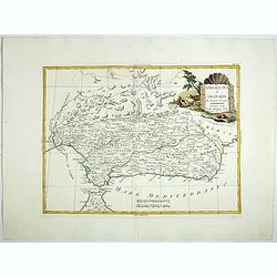
Carte des Royaumes de Congo, Angola et Benguela, avec les Pays voisins.
An interesting map of the kingdoms of Congo, angola and Benguela .Prepared by Jacques Nicolas Bellin after Dutch sources and included in Prévost d' Exile's "Histoir...
Date: Paris, 1738-1775
Selling price: ????
Please login to see price!
Sold in 2014
Carte de la Coste occidentale d'Afrique.
An interesting map of the West Coast of Equatorial Africa, from the Rio Grande in Senegal to just south of Angola .Prepared by Jacques Nicolas Bellin after Dutch sources ...
Date: Paris, 1738-1775
Selling price: ????
Please login to see price!
Sold in 2018
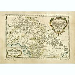
Carte de la Tartarie Occidentale.
An interesting map of Tartary and Siberia.Prepared by Jacques Nicolas Bellin after Dutch sources and included in Prévost d' Exile's "Histoire des Voyages", pub...
Date: Paris, ca. 1775
Selling price: ????
Please login to see price!
Sold in 2014
Carte du Détroit de Waeigats ou de Nassau.
An interesting map of the Northern passage in Russia.Prepared by Jacques Nicolas Bellin after Dutch sources and included in Prévost d' Exile's "Histoire des Voyages...
Date: Paris, 1738-1775
Selling price: ????
Please login to see price!
Sold in 2014
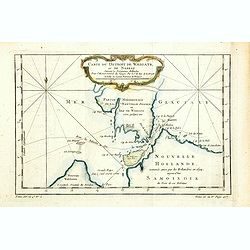
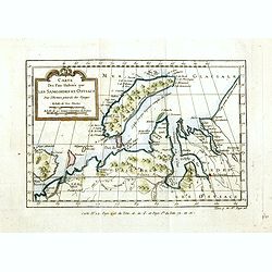
Partie de la Mer Glaciale, contenat le Nouvelle Zemble et le Pais des Samoiedes.
An interesting map of the Nova Zembla and part of the Northeast passage .Prepared by Jacques Nicolas Bellin after Dutch sources and included in Prévost d' Exile's "...
Date: Paris, ca 1775
Selling price: ????
Please login to see price!
Sold in 2014
Carte des Païs Habités par les Samojedes et Ostiacs.
An interesting map of the Nova Zembla and the coast of northern Russia .Prepared by Jacques Nicolas Bellin after Dutch sources and included in Prévost d' Exile's "H...
Date: Paris, 1738-1775
Selling price: ????
Please login to see price!
Sold in 2014
Carte de l'inde en deça du gange comprenant la presqu'iIle de l'Inde.
An interesting map of the peninsula of India with Ceylon.Prepared by Jacques Nicolas Bellin after Dutch sources and included in Prévost d' Exile's "Histoire des Voy...
Date: Paris, 1738-1775
Selling price: ????
Please login to see price!
Sold in 2017
Carte de la Tartare Orientale.
An interesting map of the Eastern Tartary.Prepared by Jacques Nicolas Bellin after Dutch sources and included in Prévost d' Exile's "Histoire des Voyages", pub...
Date: Paris, 1738-1775
Selling price: ????
Please login to see price!
Sold in 2014
Nieuwe en Naukeurige Kaart van Asia : mit daadelyke ondervindingen en Riesbeschryvingen. . .
Map of Asia with relief shown pictorially. The map is of interest for the use of Zee van Korea, the sea between Korea and Japan.
Date: Amsterdam, 1775
Selling price: ????
Please login to see price!
Sold in 2015
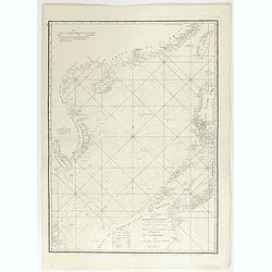
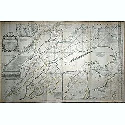
A chart of the China Sea inscribed to Monsr. D\'APRES de MANNEVILLETTE . . . To A.Dalrymple.
Most important milestone based upon the surveys made from navigational surveys by Alexander Dalrymple (1737-1808]. He was the first Hydrographer of the British Admiralty...
Date: Paris, ca. 1775
Selling price: ????
Please login to see price!
Sold in 2015
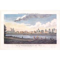
View of Twickenham from the River.
A playful river view of the village of Twickenhan in Middlesex. In th e foreground is the River Thames with two pleasure craft.
Date: London, 1775
Selling price: ????
Please login to see price!
Sold in 2019
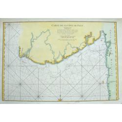
Carte de la Côte de Pégu
Detailed sea-chart of a part of Myanmar from the Irrawaddy Delta through parts of the Yangon, Bago, and Mon regions. A few towns and forts are located inland, including T...
Date: Paris, 1775
Selling price: ????
Please login to see price!
Sold in 2015
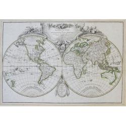
Mappe-Monde ou Description Du Globe Terrestre...
Large and very decorative double hemisphere map of the world, updated after Captain Cook's 1st voyage and the exploration of Dufresne from 1772. Shows an updated, but sti...
Date: Paris, 1775
Selling price: ????
Please login to see price!
Sold in 2015
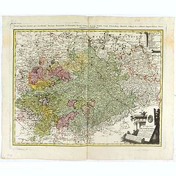
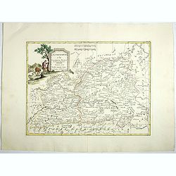
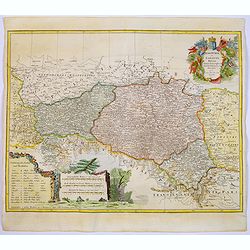
Der südliche Theil Ober-Saechsischen . . .
Kingdom of Prussia, today part of the Polish, Lithuanian and Russian territories.
Date: Augsburg, 1775
Selling price: ????
Please login to see price!
Sold in 2016
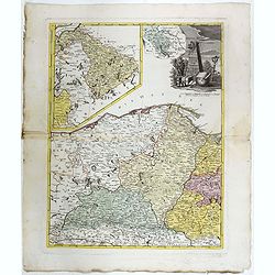
Borussiae Occidentalis tabula.
Map covering the region along the Baltic Sea from Prussia to northern Poland after F.L. Güssefeld. Beautiful ornamental title cartouche in upper right.
Date: Nuremberg, ca.1775
Selling price: ????
Please login to see price!
Sold in 2016

Le Neptune Oriental ou routier general des Cotes des Indes orientales et de la Chine. . .
b>The second, much enlarged, edition of the important French Sea Atlas of the Red Sea, India, the East Indies, Indochina and Formosa.Large folio, contemp. gilted motte...
Date: Paris, Demonville & Brest, Malassis, 1775
Selling price: ????
Please login to see price!
Sold
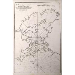
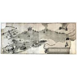
Plan De La Baye Et Du Port De Rio-Janeiro...
A scarce sea-chart with early mapping of the Guanabara Bay, with Rio De Janeiro. Published in the 1775 in the "Neptune Orientale".Interesting to see the Bay of ...
Date: Paris, 1775
Selling price: ????
Please login to see price!
Sold in 2016
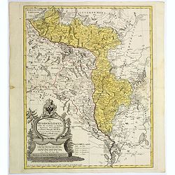
Charte von Russisch Litauen, ...
An uncommon map of Belarus, together with parts of the Ukraine and Lithuania. Shows the rivers Dnieper and Dwiner.
Date: Nuremberg, 1775
Selling price: ????
Please login to see price!
Sold in 2017
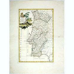
Regno Di Portogallo.
Map from "Atlas Novissimo" printed in Venice between 1776 and 1785. The map was issued in Zatta's Atlas Novissimo a monumental four volume work and one of the l...
Date: Venise, 1775
Selling price: ????
Please login to see price!
Sold in 2018
![Il Portogallo Cioé le provincie . . . [with] L'Estremadura Di Portogallo alentejo . . .](/uploads/cache/39014-250x250.jpg)
Il Portogallo Cioé le provincie . . . [with] L'Estremadura Di Portogallo alentejo . . .
Two maps of north and South Portugal from "Atlas Novissimo" printed in Venice between 1776 and 1785. The map was issued in Zatta's Atlas Novissimo a monumental ...
Date: Venise, 1775
Selling price: ????
Please login to see price!
Sold in 2017
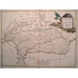
Andalusia e Granada.
Fine map of Southern Spain with the cities of Seville, Granada and Malaga, including Strait of Gibraltar. Shows administrative boundaries, major cities, villages, rivers ...
Date: Venise, 1775
Selling price: ????
Please login to see price!
Sold in 2017
La Catalogna, li regni di Aragona . . .
Double page map of Catalonia and Aragon from "Atlas Novissimo" printed in Venice between 1776 and 1785. The map was issued in Zatta's Atlas Novissimo a monument...
Date: Venise, 1775
Selling price: ????
Please login to see price!
Sold in 2017
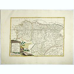
Li Regrni di Galizia, Asturies, Leon, Castiglia Vecchia . . .
Map of The Basque Country in the western Pyrenees that straddles the border between France and Spain on the Atlantic coast. From "Atlas Novissimo" printed in Ve...
Date: Venise, 1775
Selling price: ????
Please login to see price!
Sold in 2017
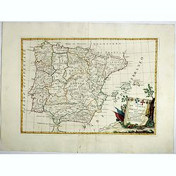
Li Regrni di Spagna E Portogallo . . .
Map of Spain and Portugal from "Atlas Novissimo" printed in Venice between 1776 and 1785. The map was issued in Zatta's Atlas Novissimo a monumental four volume...
Date: Venice, 1775
Selling price: ????
Please login to see price!
Sold in 2017
L'Estremadura e la Castiglia Nuova . . .
Map of the regions of Castille and Estremadura regions of west/central Spain by Antonio Zatta. The cities of Madrid and Toledo are depicted, as is the western border of P...
Date: Venise, 1775
Selling price: ????
Please login to see price!
Sold in 2018
Rare Russian Map (Untitled).
Very interesting, rare, Russian map including parts of the Sverdlovsk and Rostov Oblests (Russian provinces or states). Including parts of the Black and Azov Seas. This...
Date: Russia, 1775
Selling price: ????
Please login to see price!
Sold in 2017
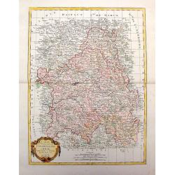
Lubomeriae Et Galliciae Regni Tabula Geographica: Cum Priv. Sac. Caes. Maiestatis Impensis Homannianorum Haeredum . . .
A rare map of the Kingdom of Galicia and Lodomeria prepared by F.L. Güssefeld, (1744-1808), who was a cartographer from Osterburg, studied at Brandenburg, worked in Weim...
Date: Nuremberg, 1775
Selling price: ????
Please login to see price!
Sold in 2017
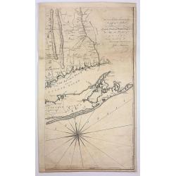
A Map of the Province of New York, With Part of Pensilvania and New England, from and Actual survey by Captain Montressor, Engineer, 1775
The Most Important Map of the British Colony of New York produced during the American Revolution.The purpose of Montressor's large scale map was for military rather than ...
Date: London, 1775
Selling price: ????
Please login to see price!
Sold in 2017
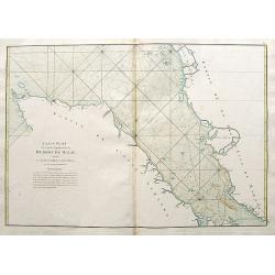
Carte Plate de la partie Septentrionale du Détroit de Malac depuis la Rade d'Achem jusqu'à Malac.
A large sea-chart of the strait of Malacca, with a part of Sumatra and Malaysia. Highly detailed with bays, depth soundings, hazards, islands, rivers, etc. A French sailo...
Date: Paris, 1775
Selling price: ????
Please login to see price!
Sold in 2018
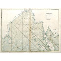
Carte Réduite du Golfe de Bengale, depuis L'isle de Ceyland jusqu'au Golfe de Siam avec la partie Septentrionale du Détroit de Malac.
A detailed chart of the ocean and coastal areas of the Gulf of Bengal, from the Island of Ceylon to the Gulf of Siam, and part of the straits of Malacca. Includes the coa...
Date: Paris, 1775
Selling price: ????
Please login to see price!
Sold in 2018
Carte du Détroit de la Sonde depuis la Pointe de Winerou jusqu'à l'Isle du Nord.
A large sea-chart of the Sunda Strait with the south-east coast of Sumatra with today's Bandar Lampung, and the western coast of Java with Bantam. With many rhumb lines, ...
Date: Paris, 1775
Selling price: ????
Please login to see price!
Sold in 2018
Carte pour aller du Détroit de la Sonde ou de Batavia au Détroit de Banca.
A large sea-chart of easter Sumatra and a part of Java, including Jakarta (Batavia). Shows the track of Julien Crozet in the year 1772. With an inset chart of islands in ...
Date: Paris, 1775
Selling price: ????
Please login to see price!
Sold in 2018
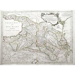
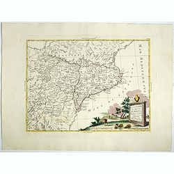
Carte de la Géorgie &c des pays situés entre la Mer Noire et la mer Caspienne.
A large, decorative and highly detailed map of the Caucasus region between the Black Sea and the Caspian Sea, including modern day Georgia, Armenia, Azerbaijan, southern ...
Date: Venice, ca. 1775
Selling price: ????
Please login to see price!
Sold in 2018
Carte des Declinaisons et Incluinaisons de Laiguille Aimantee. . .
An uncommon chart of America, designed to display the magnetic variation in the Pacific, published in Buffon's 'Histoire Naturelle', in the mineralogy volumes. One of six...
Date: Amsterdam, 1775
Selling price: ????
Please login to see price!
Sold in 2018
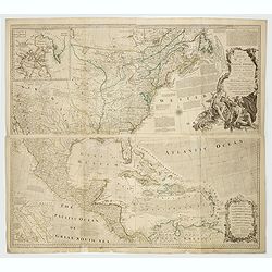
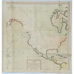
An Accurate Map of North America. Describing and Distinguishing the British and Spanish Dominions on this Great Continent. According to the Definitive Treaty Concluded at Paris 10th Feb. 1763.
The outstanding British map of North America created on the eve of the American Revolution, this is the desirable fourth Robert Sayer (1725-1794) issued 1775 edition of B...
Date: London, Robert Sayer, 1775
Selling price: ????
Please login to see price!
Sold in 2022
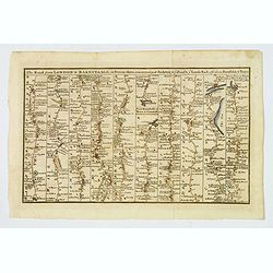
The Road from London to Barnstable, in Devonshire, commencing at Andover, in the road to the Lands End, also from Barnstable to Truro.
A highly detailed late eighteenth century road map, running left to right, commencing at Andover in Hampshire and continuing on to Barnstable in north Devonshire. The map...
Date: London, 1775
Selling price: ????
Please login to see price!
Sold in 2021
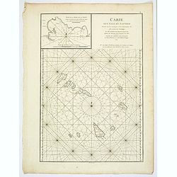
Carte des Isles du Cap-Verd. . .
A nice large chart of the Cape Verde Islands off the N.W. coast of Africa in the Atlantic Ocean. The Cape Verde Islands are an archipelago of ten volcanic islands, that w...
Date: Paris, ca 1775
Selling price: ????
Please login to see price!
Sold in 2020
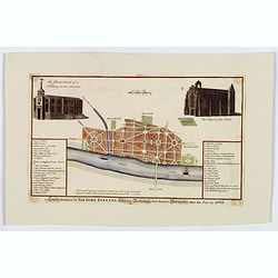
London Restored Or Sir John Evelyn's Plan for Rebuilding that Ancient Metropolis after the Fire in 1666.
John Evelyn, Wren and Hooke were among the architects and draughtsmen who submitted masterplans for a wholesale rebuilding of London after the Great Fire, proposing varia...
Date: London, 1775
Selling price: ????
Please login to see price!
Sold in 2019
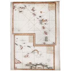
Carte Reduite des ILES ANTILLES - Carte Reduite des Debourquements de St. DOMINGUE.
A striking, large sheet with two maps of the Lesser Antilles (from the eastern tip of Puerto Rico to St. Vincent and Barbados) and of the Turks and Caicos (including part...
Date: Paris, 1775
Selling price: ????
Please login to see price!
Sold in 2020
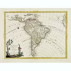
America meridionale divisa ne'fuoi principali. . .
Attractive map depicting all of South America in the grand Zatta style. Splendid ornate cartouche with Zatta's normal flourish. The map illustrates many of the primitive ...
Date: Venice, 1776
Selling price: ????
Please login to see price!
Sold in 2012
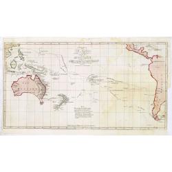
Nuove scoperte Fatte nel 1765. 67 e 69 nel Mare del Sud. . .
A very decorative map of the southern Pacific, showing the region from New Guinea to the Society Islands, marking the tracks of the explorers Carteret, Wallis, Byron and ...
Date: Venise, 1776
Selling price: ????
Please login to see price!
Sold in 2013
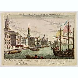
Debarquement des troupes engloises a nouvelle York.
A so-called optical print showing a fanciful view of British troops disembarking at New York City. Built environment includes churches, dwellings, ships, and boats.
Date: Augsburg, 1776
Selling price: ????
Please login to see price!
Sold in 2013
An exact chart of the River St. Laurence, from Fort Frontenac to the Island of Anticosti, shewing the soundings, rocks, shoals &c.
With five insets. A chart of the St. Lawrence River by the noted eighteenth century English cartographer Thomas Jefferys, Geographer to George III and the Prince of Wales...
Date: London, 1776
Selling price: ????
Please login to see price!
Sold in 2014
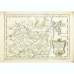
Carte du Gouvernement de Champagne et Brie
This large, very detailed, copper engraved map of French provinces is based on the earlier map by Bonne. It shows forests, cities, towns, mountains and roads and is decor...
Date: Venice, 1776
Selling price: ????
Please login to see price!
Sold in 2014
Charte von einem Theile des Süd=Meeres. . .
Showing the Pacific, with the track of the English vessel Delphin under Comodor Byron, and Tamar by Captain Mouat, in 1765. The Delphin by Captain Wallis and the Swallow ...
Date: Berlin, 1776
Selling price: ????
Please login to see price!
Sold in 2013

Atlas Universel dressé sur les meilleures cartes modernes.
Title page of the Atlas Universel dressé sur les meilleures cartes modernes >/i>. Title is set in an allegorical scene of mythological figures.
Date: Venice, 1776
Selling price: ????
Please login to see price!
Sold in 2013
Andalusia e Granada Di Novissima Projezione.
Double page map of Southern Spain with the cities of Seville, Granada and Malaga and including Gibraltar. The pictorial title cartouche shows a farmer with his cattle. Fr...
Date: Venice, 1776
Selling price: ????
Please login to see price!
Sold in 2017

This plate, the death of General Wolfe, is with his gracious permition humply dedicated by his Mayestis most dutyfully subject & servant
Representation of the battle of Quebeck with the death of General Wolf.During the 1759 Battle of Quebec of the French and Indian War, the British General James Wolfe suff...
Date: London, after 1776
Selling price: ????
Please login to see price!
Sold in 2014

The death of General Wolfe.
This original copper engraving is from "The Death of General Wolfe", famous 1770 painting by the Anglo-American artist Benjamin West. It depicts the death of Br...
Date: London, 1776
Selling price: ????
Please login to see price!
Sold in 2014
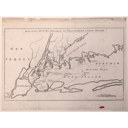
Sketch of the Country Illustrating the Late Engagement in Long Island.
An interesting map of Colonial New York.This is the first edition of this map that shows the troop positions and battle activity of this early American Revolution battle....
Date: London, October 1776
Selling price: ????
Please login to see price!
Sold in 2015
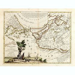
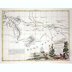
Nuove Scoperte de' Russi al Nord del Mare del Sud si nell'Asia, che nell'America...
Nice example of Zatta's map of the northern Pacific Coastal regions one of the best illustrations of a late rendition of the Northwest Passage, here illustrating two wide...
Date: Venice, 1776
Selling price: ????
Please login to see price!
Sold in 2016
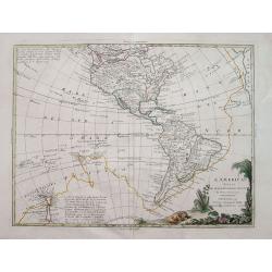
L'America divisa ne suoi principali Stati. . .
Interesting map of the Americas illustrating the first voyage of Captain Cook around South America and across the Pacific to New Zealand. Mentions a Chinese Colony in the...
Date: Venice, 1776
Selling price: ????
Please login to see price!
Sold in 2015
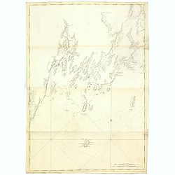
St Georges River (Owls head)
A chart of part of Maine, showing Knox County, Lincoln County and St Georges River taken from the "Atlantic Neptune", and marked in lower right corner "Pub...
Date: London, 1776
Selling price: ????
Please login to see price!
Sold in 2015
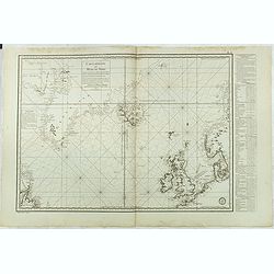
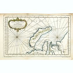
Carte réduite des Mers du Nord Comprise entre le 48° et le 72° Degré de Latitude Septle et entre le lle Degré de Longitude Orientale et le 61e. . .
Uncommon sea of the North Atlantic, published by the French Dépot de la Marine. Including the coasts of Scandinavia, the Baltic Sea, British Isles, Iceland, Greenland a...
Date: Paris, 1776
Selling price: ????
Please login to see price!
Sold in 2018
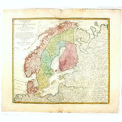
Scandinavia complectens sueciae, Daniae et Norvegiae. . .
A detailed map of Scandinavia covering Sweden, Denmark, and Norway. Published by the Homann Heirs.
Date: Nuremberg, 1776
Selling price: ????
Please login to see price!
Sold in 2019