Browse Listings
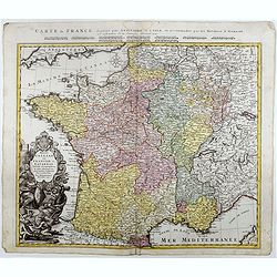
Regni Galliae seu Franciae et Navarrae.
A secondary title in French above the map : "Carte de France dressée par Guillaume de L'Isle et accomodée par les Heritiers d'Homann. With a large decorative title...
Date: Nuremberg, 1741
Selling price: ????
Please login to see price!
Sold in 2021
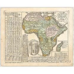
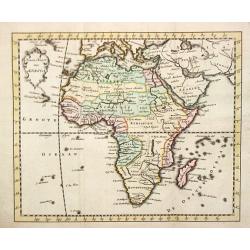
AFRICA Poly Glotta Scribendi Modos Gentium. . .
A rare separate thematic map of AFRICA from the set of 4 maps of the continents, identifying the distribution of languages of the world from "Synopsis Universae Phil...
Date: Nurenberg, 1741
Selling price: ????
Please login to see price!
Sold in 2019
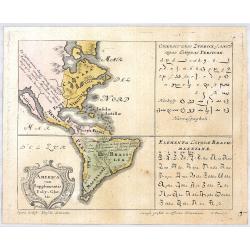
AMERICA cum Supplementis Poly Glottis.
A rare separate thematic map of AMERICA from the set of 4 maps of the continents, identifying the distribution of languages of the world from "Synopsis Universae Phi...
Date: Nurenberg, 1741
Selling price: ????
Please login to see price!
Sold in 2020
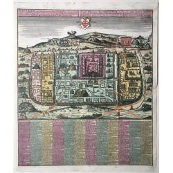
Statt Ierusalem.
Jerusalem at the time of Christ. An imaginary plan, drawn after Adrichomius. Extensive title at top in Latin (L) and German (R): ‘Ierusalem, cum suburbiis, prout tempor...
Date: Augsburg, 1741
Selling price: ????
Please login to see price!
Sold in 2020
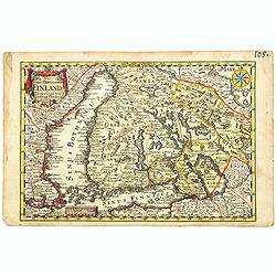
Das Gros-Hertzogthum Finland. . .
A scarce map shows the southern part of Finland with the cities Oulu, Kajana, Vasa, Helsinki, Kristinestad, Hollola and the now Russian city Wyborg in the historic area o...
Date: Leipzig, ca 1741
Selling price: ????
Please login to see price!
Sold in 2021
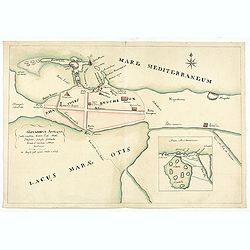
Alexandria antiqua juxta mentem . . .
Manuscript hand colored map of the ancient city of Alexandria, probably carried out by P.N. Bonamy. With an inset map. The book "Description of the City of Alexa...
Date: Paris, 1741
Selling price: ????
Please login to see price!
Sold in 2023
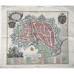
Hannoverae / Hannover
A map of the city of Hannover in Germany, 'Altstadt' and 'Neustadt'), depicted within its fortifications with all its streets and important buildings, with very detailed ...
Date: Augsburg, 1741
Selling price: ????
Please login to see price!
Sold in 2022
A compleat Body of Ancient Geography both Sacred and Profane…
The third edition enlarged with eleven maps of Laurenberg and Blanchard. Atlas with 63 engraved maps. It includes 6 maps, in 7 sheets, making up a large map of the Holy L...
Date: The Hague, and sold by T.Osborne of London 1741
Selling price: ????
Please login to see price!
Sold in 2024
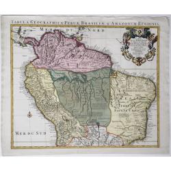
Tabula geographica Peruae Brasiliae & Amazonum Regionis.
Covens & Mortier's large size detailed map of the northern part of South America, after Guillaume De L'Isle, 1721-1742.Full title on the map: 'Tabula geographica Peru...
Date: Amsterdam, 1721-1742
Selling price: ????
Please login to see price!
Sold in 2020
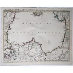
Seconde partie de la Crimee, la Mer Noire &c.
A map of the Black Sea with the coasts of the surrounding countries. From Istanbul (Constantinople) over Romania, Bulgaria, the southern tip of the Crimean, Russia, Georg...
Date: Amsterdam, 1742
Selling price: ????
Please login to see price!
Sold in 2021
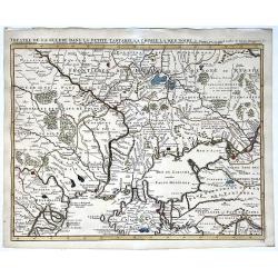
Theatre de la guerre, Petite Tartarie, Crimee, Mer Noire.
A map of the Crimea and the surrounding regions by Guillaume de Lisle, 1675-1726; Covens et Mortier, 1742. Full title and impressum above: 'Theatre de la guerre dans la P...
Date: Amsterdam, 1742
Selling price: ????
Please login to see price!
Sold in 2021
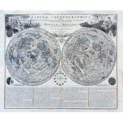
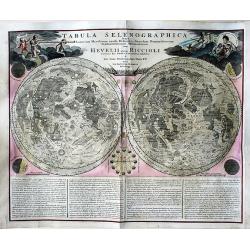
Tabula Selenographica in qua Lunarium. . .
A fantastic and important chart of the Moon after Johann Gabriel Doppelmayr, from the "Atlas Coelestis in quo Mundus Spectabilis". It shows a comparison of the ...
Date: Nuremberg, ca 1742
Selling price: ????
Please login to see price!
Sold in 2021
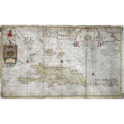
Nieuwe en Naaukeurige Paskaart van Het Eyland Hispaniola of St. Domingo met alle desselfs Havenen, Dieptens en Ankergronden, als meede de door passeeringe tusche de Caiques en andere Eylanden. ..
Fine Sea Chart of Puerto Rico and Hispaniola, published by Johannes Van Keulen II. A rare map since these larger sized sheets were never published in atlases but were ra...
Date: 1742
Selling price: ????
Please login to see price!
Sold in 2022
Nouveau Plan de la Ville de Prague Et de ses Environs, Capiltale de Bohème
A rare separately issued battle plan of Prague by Baillieul and Jombert. Showing the Siege of Prague in 1742 with deployment of troops. With one mileage scale, text carto...
Date: Paris, 1742
Selling price: ????
Please login to see price!
Sold in 2011
Asia.
An attractive pocket-size map of the Asian continent.
Date: Amsterdam, 1742
Selling price: ????
Please login to see price!
Sold
Nieuwe Kaart van Europa.
A map of Europe from a Dutch pocket-atlas.
Date: Amsterdam/ Deventer, 1742
Selling price: ????
Please login to see price!
Sold
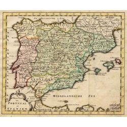
Nieuwe Kaart van Portugal en Spanjen.
A small map of the Iberian peninsula.
Date: Amsterdam/ Deventer, 1742
Selling price: ????
Please login to see price!
Sold
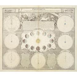
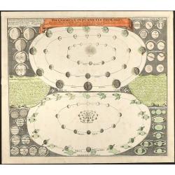
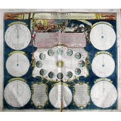
Phoenomena Motum Irregularium quos Planetae inferiores Venus et Mercurius ad annum Salutis MDCCX.
Handsome celestial chart in the form of a sphere with a large engraved scene in top left of Venus sitting in a chariot drawn by six horses, flying through the heavens abo...
Date: Nuremberg 1742
Selling price: ????
Please login to see price!
Sold
Nieuwe Kaart van Afrika.
An uncommon map of Africa.
Date: Amsterdam/ Deventer, 1742
Selling price: ????
Please login to see price!
Sold
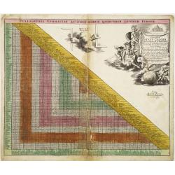
Curjoser Statt-Zeiger der vornemsten ort in Teutschland,..
Engraved by J.B.Homann and published by David Funck. Decorative table of distances between major European cities.
Date: Nuremberg 1742
Selling price: ????
Please login to see price!
Sold
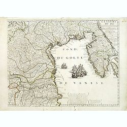
Le Cours du Pô Depuis Turin jusques a ses Embouchures. . . Ce qui fait aujourd'huy Le Théatre de la Guerre en Italie (partie droite seule).
Attractive map of the gulf of Venice, covering the Adriatic coast from the delta of the river Po as far as Istria. It shows many important towns: Ravenna, Ferrara, Vicenz...
Date: Paris, ca. 1742
Selling price: ????
Please login to see price!
Sold in 2019
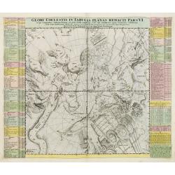
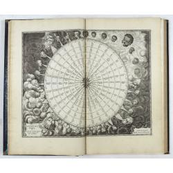
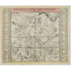
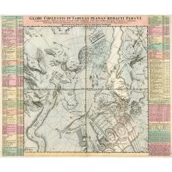
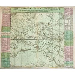
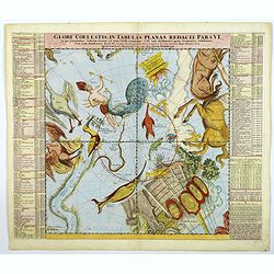
Globi Coelestis in tabulas planas redacti pars VI,..
This is the sixth chart in a series of six depicting part of the night sky on a gnomonic projection with 'the fixed stars for the end of the year of Christ 1730 'accordin...
Date: Nuremberg 1742
Selling price: ????
Please login to see price!
Sold in 2008
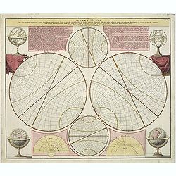
Sphaera Mundi..
An unusual comparative view of the earth rotated at various angles noting the equator and other circles dividing the earth?s surface.This chart is by the famous astronome...
Date: Nuremberg 1742
Selling price: ????
Please login to see price!
Sold
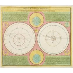
Theoria Planetarium Primariorum,..
Celestial map by Johann Gabriel Doppelmayer, astronomer and cartographer of Nuremberg.The chart has been published by Johann Baptist Homann in the "Atlas Coelestis&q...
Date: Nuremberg 1742
Selling price: ????
Please login to see price!
Sold
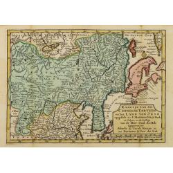
Kaartje van de Chineese Tarters en het land van Jeso..
Attractive and uncommon map of North China with Korea and Jedso. Dutch issue, of this map prepared by de L'Isle. From Atlas Portatif . With a curious and oversized Hokkai...
Date: Deventer, 1742
Selling price: ????
Please login to see price!
Sold in 2011
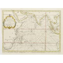
Carte De L'Ocean Oriental ou Mer Des Indes Pour Servir a l'Histoire Generale des Voyages..
Fine chart of Asia from south Africa till the western tip of Australia, including Arabia, India and Indonesia, including Philippines and Taiwan.With Dutch title in lower ...
Date: Amsterdam 1742
Selling price: ????
Please login to see price!
Sold
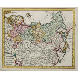
T Russische Ryk zoo in Europa als in Asia.
A map of the Russian empire both in Europe and Asia. Also depicting China and Japan.
Date: Amsterdam, 1742
Selling price: ????
Please login to see price!
Sold
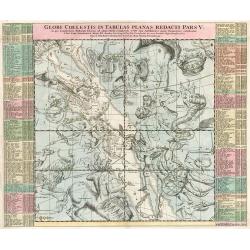
Globi Coelestis in tabulas planas redacti pars V..
This is the fifth chart in a series of six depicting part of the night sky on a gnomonic projection with 'the fixed stars for the end of the year of Christ 1730 'accordin...
Date: Nuremberg, 1742
Selling price: ????
Please login to see price!
Sold in 2008
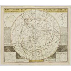
Motus Cometarum in Hemisphaerio Boreali..
Fine chart of the movements of different comets, published in the J.G.Doppelmayr Atlas Coelestis.
Date: Nuremberg, 1742
Selling price: ????
Please login to see price!
Sold
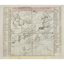
Globi Coelestis in tabulas planas redacti pars IV..
Celestial map by Johann Gabriel Doppelmayr, astronomer and cartographer of Nuremberg. The map has been published by Johann Baptist Homann in the Atlas Coelestis.Doppelmay...
Date: Nuremberg, 1742
Selling price: ????
Please login to see price!
Sold in 2008
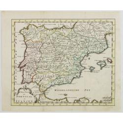
Nieuwe Kaart van Portugal en Spanjen.
Attractive and uncommon map of Spain and Portugal. From Atlas Portatif . RARE.
Date: Amsterdam/ Deventer, 1742
Selling price: ????
Please login to see price!
Sold in 2008
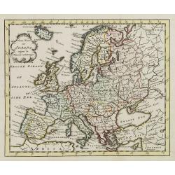
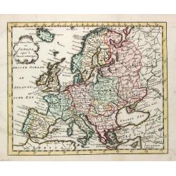
Nieuwe Kaart van Europa.
Attractive and uncommon map of Europe. From Atlas Portatif. RARE.
Date: Amsterdam/ Deventer, 1742
Selling price: ????
Please login to see price!
Sold in 2009
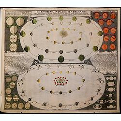
Phaenomena in Planetis Primariis Quae facies diversas, ex illorum phasibus, maculis et fasciis seu zonis ortas sistunt, exhibita
Copper engraved map of the major planets by J. G. Doppelmayr. Showing the phases of the planets (Mercury, Venus, Mars, Jupiter, Saturn) as it can be seen from the Earth, ...
Date: Nuremberg, 1742
Selling price: ????
Please login to see price!
Sold in 2011
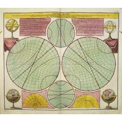
Sphaera Mundi..
An unusual comparative view of the earth rotated at various angles noting the equator and other circles dividing the earth's surface.This chart is by the famous astronome...
Date: Nuremberg, 1742
Selling price: ????
Please login to see price!
Sold in 2012
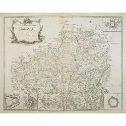
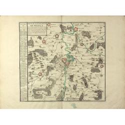
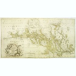
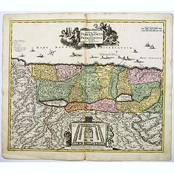
Carte Particuliere de la Moravie Divisée en six Cercles . . .
Detailed map of former Czechoslovakia now part of the province of Moravia and Silesia. From the original survey by Mr. Muller with inset plans of Olmutz, Iglaw, Neustatt ...
Date: Paris, 1742
Selling price: ????
Please login to see price!
Sold in 2023
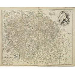
Le Royaume de Boheme. Carte reduite sur celle de 25 feuilles faite a Prague, par Müller, a Paris. Par et chez le sieur leRouge Ingr. Géographe du Roy . . .
Uncommon general map of the Czech Republic, centered on Prague. Prepared after the 25 sheet wall map of Muller, and published by Le Rouge. Folio maps by Le Rouge are quit...
Date: Paris, 1742
Selling price: ????
Please login to see price!
Sold in 2010
Tabula Coelestis in tabulas planas redacti pars V.
Celestial map of Hercules, Aquila, Scorpius,..
Date: Nurnberg, 1742
Selling price: ????
Please login to see price!
Sold in 2010
Globi Coelestis in tabula planas redacti pars VI.
Celestial map of Indus, Pavo, Centaurus,..
Date: Nurnberg, 1742
Selling price: ????
Please login to see price!
Sold in 2010
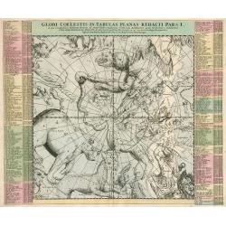
Globi Coelestis in tabulas planas redacti pars I.
Celestial map of Ursus major, Draco, Cepheus,..
Date: Nurnberg, 1742
Selling price: ????
Please login to see price!
Sold in 2010
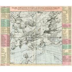
Globi Coelestis in tabulas planas redacti pars IV.
Celestial map of Virgo, Leo, Corvus, Centaurus,...
Date: Nurnberg, 1742
Selling price: ????
Please login to see price!
Sold in 2010
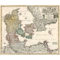
Regni Daniae in quo funt ducatus holsatia et slesvicum insulae danicae provinciae Iutia scania blekingia nova tabula
Denmark by Homann
Date: Nurnberg, 1742
Selling price: ????
Please login to see price!
Sold in 2010
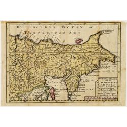
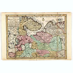
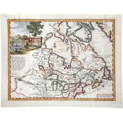
Het oosterdeel van de Moscoviesche Tarters. . .
Uncommon map of Russia and representing Siberia and including Kamchatka. This map is credited to Johann Matthias Haas (1684-1742) and Guillaume De l'Isle.
Date: Deventer, Almelo, 1742
Selling price: ????
Please login to see price!
Sold in 2012
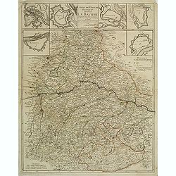
Cours du Danube feuille II contenant la Bavière suivant les cartes faites sur les lieux Par Homann et Seuter. . .
Detailed map representing the south of Germany and centered on the Danube. In the upper part six cartouches representing different important cities : Munich, Salzburg, Re...
Date: Paris, 1742
Selling price: ????
Please login to see price!
Sold in 2011
Sphaera Mundi. . .
An unusual comparative view of the earth rotated at various angles noting the equator and other circles dividing the earth’s surface.This chart is by the famous astrono...
Date: Nuremberg, 1742
Selling price: ????
Please login to see price!
Sold in 2012
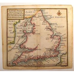
A Chart Shewing the Sea coast of England & Wales.
A fine map drawn by Thomas Badeslade and engraved by William Henry Toms which was published in the atlas "Chorographia Britannia". Thomas Badeslade (active 172...
Date: London, 1742
Selling price: ????
Please login to see price!
Sold in 2013
Charta öfwer Mälaren, med Kongl: Maj.ts. nådigste privilegio utgifven af Kong:e Landtmäteri Contoiret.
A scarce map of the district of Mälaren Sweden. A large title cartouche upper left and a key in the lower left corner. The map is a part of a work by Kongl. Landtmäteri...
Date: Stockholm, 1742
Selling price: ????
Please login to see price!
Sold in 2015
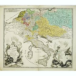
Carte D'Allemagne Et D'Italie Contenant La Succession de l'Empereur Charles VI. Ou sont marqués les Etats presents des Princes de l'Empire
Uncommon map showing the territories after the reign of Charles VI, who was emperor of the Holy Roman Empire, which he ruled from 1711 until 1740). Charles VI's was fathe...
Date: Paris, 1742
Selling price: ????
Please login to see price!
Sold in 2012
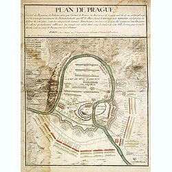
Plan de Prague.
Rare and separately published plan of Prague published by Joan Baptista Nolin with the address à l'enseigne de la Place des Victoires et chez le Sr. Humblot rue St. Jaqu...
Date: Paris, ca. 1742
Selling price: ????
Please login to see price!
Sold in 2012
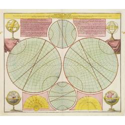
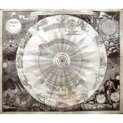
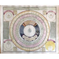
Phaenomena circa quantitatem dierum artificialium et solarium perpetuo mutabilem...
Fantastic celestial chart, published in the famous Atlas Coelestis. Shows the Earth's orbit around the sun, surrounded by seven other charts with planetary orbits and th...
Date: Nuremberg, 1742
Selling price: ????
Please login to see price!
Sold in 2013
Globi Coelestis in tabulas planas redacti pars II.
Celestial map by Johann Gabriel Doppelmayr, astronomer and cartographer of Nuremberg. Map has been published by Johann Baptist Homann in the Atlas Coelestis. The position...
Date: Nuremberg, 1742
Selling price: ????
Please login to see price!
Sold in 2019
Virginia, Maryland, Pennsilvania, East & West New Jarsey.
Important early English Chart of the Chesapeake and Delaware Bay region, based on a map by Augustine Hermann.Originally issued by John Thornton and William Fisher in 1689...
Date: London, ca 1742
Selling price: ????
Please login to see price!
Sold in 2013
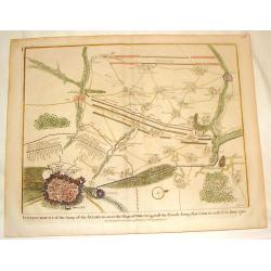
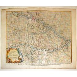
Plan of the Army of the Allies to Cover the Siege of Douay.
Fine detailed plan of the Siege of Douay in 1710. Copper engraving featuring the city of Douay and the Fort of Scarpe. Nicholas Tindal (1687-1774) / Paul de Rapin (1661-...
Date: London, 1742
Selling price: ????
Please login to see price!
Sold in 2016
Plan of the Situation Where the Battle of Ramillies was Fought.
Battle Plan of the famous battle in 1706 in Flanders. Detailed cities as well as the battle. colored copper engraving. Nicholas Tindal (1687-1774) / Paul de Rapin (1661-1...
Date: London, 1742
Selling price: ????
Please login to see price!
Sold in 2016
Plan of the Lines of Brabant.
Fine copper engraved plan featuring the 1705 battle in Brabant between the Duke of Marborough and Field-Marshall d'Averquerque. Decorative rococco cartouche with the expl...
Date: London, 1742
Selling price: ????
Please login to see price!
Sold in 2016
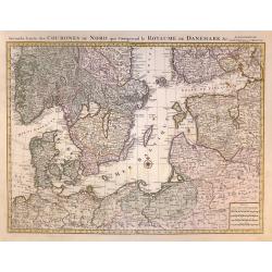
Seconde Carte des COURONES DU NORD qui Comprend le ROYAUME DE DENEMARK &c.
A superb, large scale sheet map of Scandinavia,Finland Estonia,and part of Russia by one of France's greatest cartographers, This is one of a two part map from a Dutch ed...
Date: Amsterdam, 1742
Selling price: ????
Please login to see price!
Sold in 2020
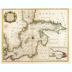
A correct chart of the Baltick or East Sea from ye Sound to St. Petersburg. . .
Attractive uncommon sea chart of the Baltic Sea. Inset plan of St Petersburg (97x131mm.) . Compass rose and rhumb lines. Decorative title cartouche. Engraved by R.W. Seal...
Date: London, 1742
Selling price: ????
Please login to see price!
Sold in 2015
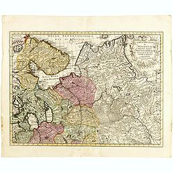
Het oosterdeel van de Moscoviesche Tarters. . .
Scarce map of Russia. This map is credited to Guillaume De l'Isle.
Date: Deventer, Almelo, 1742
Selling price: ????
Please login to see price!
Sold in 2014
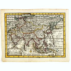
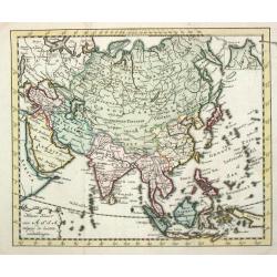
Kaartje van Asia. . .
Attractive and rare map of Asia. From Atlas Portatif . With a curious and oversized Hokkaido. The map is of interest for the use of Coreanse Zee for the sea between Korea...
Date: Deventer 1742
Selling price: ????
Please login to see price!
Sold in 2014
Carte nouvelle de Moscovie represente la partie Septentrionale dressée par G.De L'Isle. . .
Rare map covering the area north of Moscow, including Lapland. Prepared by G. de L'Isle.
Date: Amsterdam, 1742
Selling price: ????
Please login to see price!
Sold in 2015
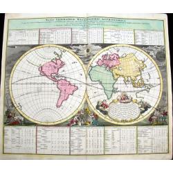
Basis Geographie Recentioris Astronomica...
Very decorative twin-hemisphere map from Doppelmayr's Celestial Atlas. The map includes California as an Island, incomplete coasts in Alaska, strangely shaped Asia, an in...
Date: Nuremberg, 1742
Selling price: ????
Please login to see price!
Sold in 2016
Phaenomena in Planetis Primariis Quae facies diversas, ex illorum phasibus, maculis et fasciis seu zonis ortas sistunt, exhibita
Copper engraved map of the major planets by J. G. Doppelmayr. Showing the phases of the planets (Mercury, Venus, Mars, Jupiter, Saturn) as it can be seen from the Earth, ...
Date: Nuremberg 1742
Selling price: ????
Please login to see price!
Sold in 2015
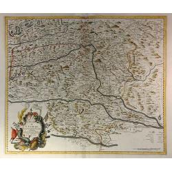
Le Duché de Stirie Suivant les Dernières Observations
The map shows the area of the Steiermark in Austria, comprising Sofron, Nagykanizsa to the east, the south Krsko, Klagenfurth and Radstadt in the west and in the north of...
Date: Paris, 1742
Selling price: ????
Please login to see price!
Sold in 2023
Novissima totius Terrae Sanctae sive promissionis. . .
Engraved by J.B.Homann and published by David Funck. One of the very few maps engraved by Johan Baptist Homann, signed lower right.A scarce map of the Holy Land, orientat...
Date: Nuremberg, 1742
Selling price: ????
Please login to see price!
Sold in 2021
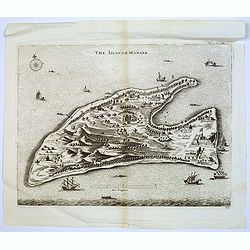
The Island of Manaer.
The island of Manaer (Mannar) is connected to northern Srl Lanka by a small causeway. This map appeared in Churchill's work 'A Collection of Voyages and Travels', and is ...
Date: London, ca. 1742
Selling price: ????
Please login to see price!
Sold in 2016
Tabula Selenographica in qua Lunarium Macularum exacta Descriptio secundum Nomenclaturam Praestantissimorum Astronomorum tam Hevelii quam Riccioli Curiosis Rei Sidereae Cultoribus exhibetur Joh. Babr. Doppelmajero Math. P.P. upera Joh. Baptistae Homanni..
An uncommon, extremely decorative chart of the surface of the moon divided in hemispheres, from the famous "Atlas Coelestis" of Johann Gabriel Doppelmayr. Doppe...
Date: Nuremberg, 1707-1742
Selling price: ????
Please login to see price!
Sold in 2017
![[7 sheets] A Map of the British Empire in America with the French Spanish and Dutch Possessions adjacent thereto by Henry Popple.](/uploads/cache/38145-250x250.jpg)
[7 sheets] A Map of the British Empire in America with the French Spanish and Dutch Possessions adjacent thereto by Henry Popple.
Seven map sheets, uncut, the first six with colored borders and outline coloring, each approximately 515 x 498 images (550 x 664 mm). Including the preliminary key map, f...
Date: Amsterdam, 1742
Selling price: ????
Please login to see price!
Sold in 2017
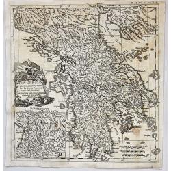
La Grecia Propriamenete Detta per la Storia Romana.
A superb map of the region of present-day Greece. The map which shows Greece under rule by the Roman Empire is well engraved with excellent detail in D'Anville's simple, ...
Date: Paris, 1742
Selling price: ????
Please login to see price!
Sold in 2021
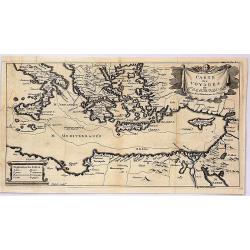
Carte des Voyages de Telemaque.
This interesting map is from “The Adventures of Telemachus” which is a didactic French novel by Fénelon, the Archbishop of Cambrai, and tutor to the seven-year-old ...
Date: Paris, 1742
Selling price: ????
Please login to see price!
Sold in 2019
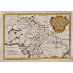
Carta dell India, Foglio II.
A fine map of the northern part of India by Bellin. A copper engraved map from the “Storia Generale de'Viaggi” di Prevost, an Italian edition of the French original �...
Date: Paris, 1742
Selling price: ????
Please login to see price!
Sold in 2019
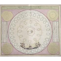
Motus Planetarum Superiorum.
A map that depicts the movements of the Jupiter, Saturn and Mars. The sun is in the centre. With beautiful decorative angels.
Date: Nuremberg ca. 1742
Selling price: ????
Please login to see price!
Sold in 2018
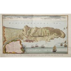
Plan of the fortifications of Gibraltar, exactly taken on the Spot in the Year 1738.
A map showing Gibraltar in Spain with decorative ships in the foreground. It is very likely that the author of this map was Nicholas Tindall: as Chaplain to an English Fl...
Date: London ca. 1742
Selling price: ????
Please login to see price!
Sold in 2018
Systema Solare et Planetarium. . .
A fantastic celestial chart showing the motion of the planets, and the zodiac signs according to Copernicus. In the bottom left with a solar eclipse projected onto a terr...
Date: Nuremberg, 1742
Selling price: ????
Please login to see price!
Sold in 2018
Globi Coelestis in tabulas planas redacti pars VI.
This is the sixth, and final chart in a series of six depicting part of the night sky on a gnomonic projection with 'the fixed stars for the end of the year of Christ 173...
Date: Nuremberg, 1742
Selling price: ????
Please login to see price!
Sold in 2018
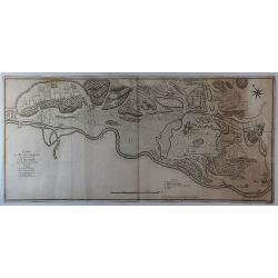
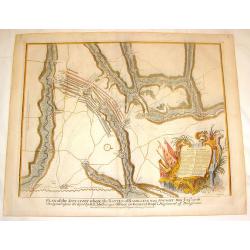
Camp de Mr. le Duc D'Harcourt Pres de Deckendorf en Baviere.
A folded plan of the Camp of the Duke of Harcourt near Deckendorf in Bavaria, Germany on 2 sheets. It showing streets, rivers, canals, forests, buildings and marches. It ...
Date: Paris, 1742
Selling price: ????
Please login to see price!
Sold in 2018
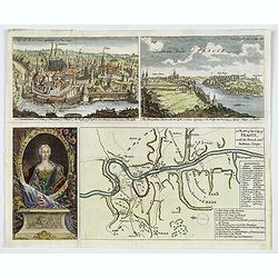
A Plan of the City of Prague, with the French and Austrian Camps.
An interesting plan showing the Battle of Prague (1742) with a pair of attractive birds-eye views of Prague and Egra, plus an engraving of the Queen of Hungary, Maria Ter...
Date: London, ca 1742
Selling price: ????
Please login to see price!
Sold in 2019
Astronomia comparative...Planetis nostri respectu, Marte, Iove et Saturno sistuntur. . .
Plate nr.30 from the famous "Atlas Coelestis". The synodic periods of the outer planets as observed from the Earth and other planets. Insets depicting the Tycho...
Date: Nuremberg, 1742
Selling price: ????
Please login to see price!
Sold in 2019
CARTA GEOGRAFICA DEL CANADA. NELI: AMERICA SETTENTRIONALE.
A striking hand-colored map of the Great Lakes, Canada and northeastern US, based upon Guillaume De L'Isle's map of 1703, which was then one of the most accurate and up t...
Date: Venice, 1742
Selling price: ????
Please login to see price!
Sold in 2019
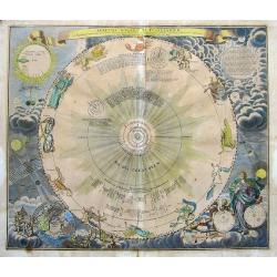
Systema Solare et Planetarium. . .
A fantastic celestial chart showing the motion of the planets, and the zodiac signs according to Copernicus. In the bottom left with a solar eclipse projected onto a terr...
Date: Nuremberg, 1742
Selling price: ????
Please login to see price!
Sold in 2019
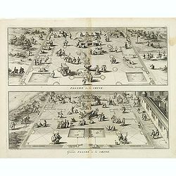
Pagode de la Chine. - Grande Pagode de la Chine.
Two scenes on one page showing scenes on the square of a Pagoda, probably in Changzhou. Fine copper engraving by Bernard Picart and taken from Bernard Picart's famous Cé...
Date: Amsterdam, 1743
Selling price: ????
Please login to see price!
Sold in 2012
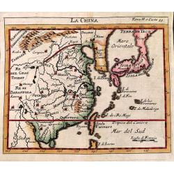
La China.
Smaller format map of China based on the work of De L'Isle.The map is of interest for the use of Sea of Japan / East Sea, the sea between Korea and Japan, here called &qu...
Date: ca. 1743
Selling price: ????
Please login to see price!
Sold in 2012