Subscribe to be notified if similar examples become available.
Globi Coelestis in tabulas planas redacti pars V.. |
||||||||||||||||||||
|
||||||||||||||||||||
|
|
||||||||||||||||||||
|
Selling price: $ Please login to see price!
Sold in 2008 Missed this item! Add your name to our mailing list and be the first to get notified about our newly added listings. . |
My Collection + - Save and collect this or any of your favorite items in one place.
If you want to save the items permanently, please sign in or create account first. |
|||||||||||||||||||
Description
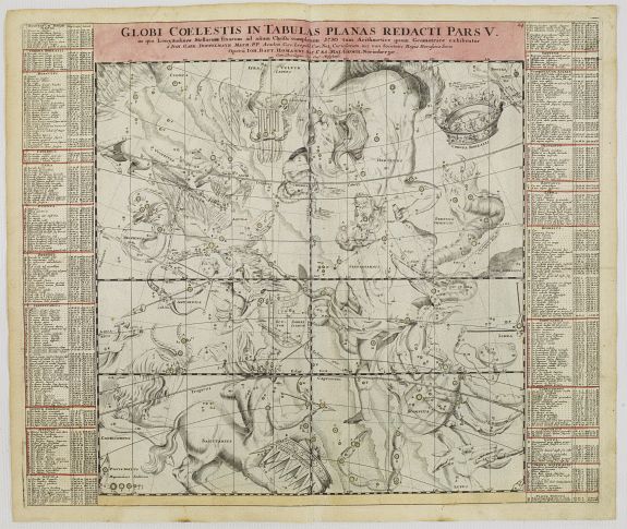
This is the fifth chart in a series of six depicting part of the night sky on a gnomonic projection with 'the fixed stars for the end of the year of Christ 1730 'according to the rules of arithmetic and geometry.
The constellations are shown as figures according to classical mythology and the zodiac as derived from Hevelius. The more recently named constellations are shown as scientific instruments.
The paths of several comets are traced following a pattern established by Pardies.
Specifically this chart is an internal view of the sky centered on the equator above the winter solstice in a gnomonic projection between the declinations 45° North and 45° South.
Also depicted are the paths of the comets C/1577 V1 (observed by Tycho Brahe), 1P/1607 S1 [Halley s Comet] (Johannes Kepler), C/1661 C1 (Johannes Hevelius), C/1680 V1 (John Flamsteed), C/1702 H1 (Philippe de la Hire) and C/1707 W1 (Giovanni Domenico Cassini).
The comet of 1692 (observed by Philippe de la Hire) does not seem to be mentioned in modern cometographies.
Doppelmayr wrote on astronomy, geography, cartography, spherical trigonometry, sundials and mathematical instruments. He often collaborated with the cartographer Johann Baptista Homann (1664-1724), a former Dominican monk from Oberkammlach in Schwabia who in 1688 had settled in Nuremberg and became a map engraver for the publishing firms of Jacob von Sandrart and David Funck. In 1702, Homann founded an influential cartographic publishing firm that after his death was continued by his son Johann Christoph Homann (1703-1730) and after the latter s death by his friend Johann Michael Franz (1700-1761) and his stepsister s husband Johann Georg Ebersberger (1695-1760) under the name Homännische Erben . The publishing firm remained in business under different names until 1848. Celestial map by Johann Gabriel Doppelmayr, astronomer and cartographer of Nuremberg. The map has been published by Johann Baptist Homann in the Atlas Coelestis . Johann Gabriel Doppelmayr may be considered one of the most famous scientists of Nuremberg, Germany. He was born in Nuremberg in 1671, studied in Altdorf and Halla and traveled for some time in Germany, the Netherlands and England.
FAQ - Guarantee - Shipping
Buying in the BuyNow Gallery
This item is available for immediate purchase when a "Add to Cart" or "Inquire Now" button is shown.
Items are sold in the EU margin scheme
Payments are accepted in Euros or US Dollars.
Authenticity Guarantee
 We provide professional descriptions, condition report (based on 45 years experience in the map business)
Paulus Swaen warrants the authenticity of our items and a certificate of authenticity is provided for each acquired lot.
Condition and Coloring
We indicate the condition of each item and use our unnique HiBCoR grading system in which four key items determine a map's value: Historical Importance, Beauty, Condition/Coloring and Rarity.
Color Key
We offer many maps in their original black and white condition. We do not systematically color-up maps to make them more sellable to the general public or buyer.
Copper engraved or wood block maps are always hand colored. Maps were initially colored for aesthetic reasons and to improve readability. Nowadays, it is becoming a challenge to find maps in their original colors and are therefor more valuable.
We use the following color keys in our catalog:
Original colors; mean that the colors have been applied around the time the map was issued.
Original o/l colors; means the map has only the borders colored at the time of publication.
Colored; If the colors are applied recently or at the end of the 20th century.
Read more about coloring of maps [+]
Shipping fee
A flat shipping fee of $ 30 is added to each shipment by DHL within Europe and North America. This covers : International Priority shipping, Packing and Insurance (up to the invoice amount).
Shipments to Asia are $ 40 and rest of the world $50
We charge only one shipping fee when you have been successful on multiple items or when you want to combine gallery and auction purchases.
Read more about invoicing and shipping
FAQ
Please have a look for more information about buying in the BuyNow gallery
Many answers are likely to find in the general help section.
My Collection+
![]()
With My Collection+ you can collect all your favorite items in one place. It is free, and anyone can create his or her virtual collection.
Unless you are logged in, the item is only saved for this session. You have to be registed and logged-in if you want to save this item permanently to My Collection+.
Read More[+]
Register here, it is free and you do not need a credit card.
Add this item to
My Collection+
or click the following link to see My Collection+.
| Digital Image Download | |
|
Paulus Swaen maintains an archive of most of our high-resolution rare maps, prints, posters and medieval manuscript scans. We make them freely available for download and study. Read more about free image download |
Click the image for a free small image download. |
In accordance with the EU Consumer Rights Directive and habitually reside in the European Union you have the right to cancel the contract for the purchase of a lot, without giving any reason.
The cancellation period will expire 14 calendar days from the day after the date on which you or a third party (other than the carrier and indicated by you) acquires, physical possession of the lot. To exercise the right to cancel you must inform Paulus Swaen Inc, of your decision to cancel this contract by a clear statement (e.g. a letter sent by post, or e-mail (amsterdam@swaen.com).
To meet the cancellation deadline, it is sufficient for you to send your communication concerning your exercise of the right to cancel before the cancellation period has expired.
